St Marys sits between South Creek which forms the western boundary and Ropes Creek, its eastern boundary. The Western train line splits the suburb into northern and southern halves. The northern portion of St Marys/Dunheved is abundant with trade (especially automotive), manufacturing, waste processing, and storage centers, yet also contains a leagues club. In contrast, the southern end of St Marys is a commercial and residential hub, with Queen Street functioning as the 'main street' retail district alongside separate shopping centers, a town square, a swimming pool, community centers, sports fields, and schools.[2]
History
The township of St Marys was first known as South Creek. The Bennett coach and wagon works manufactured horse-drawn wagons to meet the growing demand for transport in Sydney.[3] There are currently three such wagons on display, each in its own enclosure, at South Creek Park (on the northern side of the Great Western Hwy, east of South Creek).[4]
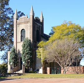
The suburb is named after the parish church of St Mary Magdalene, which was built between 1837 and 1840 and modeled after the church of the same name in Cornwall.[5] The church is situated on Magdalene Street between the Great Western Highway and King Street. The church foundation stone was laid on 22 November 1837 by Bishop Broughton, and the cathedral, along with being heritage-listed, is one of the oldest churches in New South Wales that still has regular services.[6][7][8] Internees in the church cemetery include the wife of Philip Gidley King, Governor of New South Wales, plus numerous members of the King family. The land was donated by King's son and the bricks were made on his estate. The nearby King, Gidley and Lethbridge streets were named after various members of the King family.[9]
The site is believed to have been chosen by the mother of Phillip Parker King. The property had been acquired from John Oxley in 1828 by King, the original grant having been made in 1823. Other land grants in the area included those to Anna Josepha King in 1807 (Dunheved), Samuel Marsden (Mamre), and Mary Putland (Frogmore).
The area was first called South Creek because European settlement was originally centred along the banks of the creek. The land grants became working holdings because of the permanent water supply. The rich alluvial soil along the banks of the creek ensured an expanding agricultural community and its location on what was then called the Great Western Road, later renamed to the Great Western Highway, meant that it became a convenient staging post.[citation needed]
The name St Marys was first used when the St Mary's Post Office was opened on 1 October 1840.[10] The township formed part of a grant to Mary Putland (later married Sir Maurice O'Connell), the daughter of Governor William Bligh (former master of HMSBounty, during the famous mutiny in 1789). Closer settlement of the area was made possible when in 1842 part of the O’Connell Estate was subdivided.[11]
St Marys has a long and rich industrial and agricultural history, including tanneries and munitions formerly operated by Australian Defence Industries.[12][13][14][15][16]
Mamre, situated on Mamre Road, was built c.1830 for Samuel Marsden. It is a two-storey Georgian home that is heritage-listed.[17]
Circa 1829–32, the Lethbridge family built Werrington House just north of St Marys.[18] It was based on the family home in Cornwall. It is one of the most significant colonial homes in New South Wales and is heritage-listed.[17][19]
St Marys is now the home of the South Creek/St Marys Outpost sub-branc of the Vietnam Veterans Association and the St Marys & District Historical Society Inc.[20][21][22]
Municipality of St Marys
The Municipality of St Marys was proclaimed on 3 March 1890, and the election of the first council was held in May 1890.[citation needed] The council was amalgamated with the Municipality of Penrith on 1 January 1949.[23] The first Mayor was William Garner, and the last mayor was J J Blair (1948).[24] There is a branch office of the Penrith City Council on Queen Street along with a library. The St Marys & District Historical Society is open to the public on Wednesdays and Saturdays from 10 am to 2 pm in the Community Centre complex located on Mamre Road on the southern side of the Great Western Highway.[22]
Heritage listings
St Marys has a number of heritage-listed sites, including:
Italianate house, known as 'Bronte', located on the corner of Gidley Street and King Street. The house was built in 1889 for James Bennet Jr, local wagonwright.[29]
Greek Orthodox Church, Hobart Street[30] The church also has facilities for a Greek-language school, which offers Greek-language and cultural lessons for school-aged attendees[31]
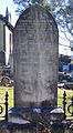
Grave dated 1818, cemetery of St Mary's Anglican Church
Grave of members of the King family, cemetery of St Mary's Church
St Marys RSL, corner Hall Street and Mamre Road. The RSL also houses an office of the St Marys Vietnam Veterans' Outpost, which holds meetings in the train carrages in front of the RSL.[32][33]
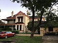
Mimosa, a Victorian-style house built for the family of Andrew Thompson, a local tanner and businessman.[2] The house was reported by the 1984 September issue of the Nepean Times newspaper to be "the costliest building in the Nepean District" at the time of its completion.[34]
St Marys War Memorial, along Great Western highway. The memorial was built in honour of the deceased war veterans who perished during the First (1914 - 1918) and Second World (1939 -1945) Wars, the Korean war (1950 - 1953), the Vietnam War (1955 - 1975), and the Malayan Emergency (1948 - 1960) [35]
Mamre Homestead. Once owned by Samuel Marsden, the property is now listed on the NSW State Heritage Register
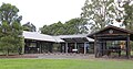
The outdoor Bennett Wagon exhibit at South Creek park, near the western limit of St Marys.[36] There are three wagons within the enclosure, outdoor seating, and a plaque outlining the history of the Bennett Wagon Works significance to the suburb.
The southern entrance of St Marys train station after the metro line renovation. The tower, which once sported a functioning clock face, is now bare. In the background is a multi-storey carpark on the northern entrance of the station, beyond which lies the industrial half of the suburb.
One of two painted historical murals in St Marys near Queen Street. Several icons of the suburb's history and landmarks are depicted, such as Bennett's Wagon Works, St Marys Magdalene Church, tannery workshops, the St Marys District Band,[37] and possibly the post office
One of two painted historical murals in St Marys. The leftmost section recites a poem titled 'South Creek' which tells of the rough journey that the pioneers made - from the eastern shoreline of Sydney, inland towards the Blue Mountains - and legacy of their settlements that they passed to their descendants. The right two-thirds of the mural depict the heritage-listed Mimosa house, the War Memorial in Victoria Park, one of Bennett works' wagons, and several persons of historical note
Decorative hedge that spells 'St Marys', situated on the corner of South Creek Park, near the western end of the suburb
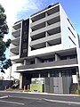
One of the new multi-storey apartment buildings in St Marys, a result of development in anticipation of the new metro line to the Badgerys Creek Aerotropolis. There is also a large print photo depicting a Bennett wagon (lower middle) - a remembrance of the suburb's past in the wake of progress and modernization
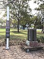
A small memorial within Lang Park, west of Queen street, which commemorates the men and women who worked at the St Marys munitions factory during World War II. A sign is inscribed with the story of the factory's development during the war and the significance of its remnants in the present day; beside the sign is a trolley carrying four bomb shell casings [38]
Demographics
According to the 2016 census of Population, there were 12,195 people in St Marys.
Aboriginal and Torres Strait Islander people made up 4.1% of the population.
The most common ancestries were Australian 20.4%, English 20.0%, Irish 5.8%, Scottish 4.7% and Filipino 4.0%
60.2% of people were born in Australia. The next most common countries of birth were New Zealand 4.1%, Philippines 3.9%, India 3.2%, England 1.8% and Fiji 1.3%.
63.7% of people spoke only English at home. Other languages spoken at home included Tagalog 2.5%, Arabic 2.4%, Samoan 1.8%, Hindi 1.7% and Punjabi 1.3%.
The most common responses for religion were Catholic 28.9%, No Religion 19.2% and Anglican 13.3%.[1]
Industrial area
The northern half of St Marys, demarcated by the train line, is the site of numerous industrial and trade businesses, along with smaller specialist enterprises, most of which are situated alongside or branch from Glossop and Forrester roads.
The automotive industry has a major presence with wreckers, multiple kinds of workshops (paint, body, tyre and auto, brake and clutch, electrical, etc.), and car dealerships operating in the area.
Waste treatment facilities also occupy north St Marys, with several major sites as follows:
Cleanaway St Marys Liquid Waste Services (provides waste disposal and treatment services for both households and businesses)[39]
Penrith City Council's Community Recycling Centre (council drop-off point for hazardous household waste to be disposed of in a safe manner)
Sydney Water's 'St Marys Advanced Water Treatment Plant' (government water treatment facility that processes 60 Megalitres of water daily[40])
Commercial area
The commercial area in the southern half of St Marys is primarily on and around Queen Street, with a collection of both franchised and independently-owned establishments lining both sides of the thoroughfare. There are also some businesses along Railway Street adjacent to the southern side of train station, and a few along the Great Western Highway such as Aldi, Dominoes, a medical center, and the St Marys Band Club.
St Marys Village Shopping Centre
St Marys Village Shopping Centre is located on Charles Hackett Drive. This sub-regional centre includes Woolworths, Target and over 40 specialty stores.[41] The centre provides convenient shopping over a single level with easily accessible ground level parking.[42] Within the shopping centre is a community noticeboard, in the corridor opposite the centre management office.
Station Plaza
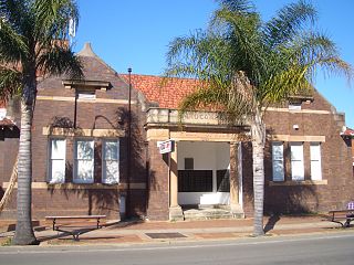
Station Plaza was a shopping centre which included a Coles Supermarket, around 16 specialty stores, and an undercover car park. It was located on Phillip Street opposite the St Marys train station and bus depot.[43] The plaza and carpark were demolished in early 2023 to clear the land for the new Metro Station as part of the Aerotropolis and Metro line development plan.[44]
Hotels
St Marys Hotel is located on Queen Street. The hotel opened in 1955 and was originally the St Marys Rex Hotel.[45]
The Wagon Wheel Hotel is another local pub/accommodation and derives its name from 'Bennet's Coach & Waggon Works', the business that was operated by brothers George T and James Jr. Bennet and which was situated near Queen Street from 1875 until its closure in 1920 (or 1858-1954 depending on the source).[46][47][48] Although initially named 'The Waggon Wheel' from its establishment in 1859 by James William Bennet (the father of George T and James Jr.), the hotel was renamed after the first world war to 'The Park View', but reverted back to 'The Waggon Wheel' in 1959.[46] The name again changed back to 'Park View' in the late 90s', then to 'King of the Mountain' in 2006, and finally to 'The Wagon Wheel Hotel' which it is currently known as.[46]
On the north side of St Marys is the Holiday Inn, which has a modern design and is adjacent to the St Marys leagues club.[49]
Arts and culture
Artistic painted murals along and around Queen Street
There is a small arts scene in St Marys, with sections of Queen Street being adorned in murals designed by independent artists, likely commissioned by the local council. Many of these can be viewed on a single walking route or 'street art trail'.[50][51]
Open-air concerts, holiday events, and family-friendly activities are often held in Coachmans park, around the middle of Queen Street.[52]
In addition, the St Marys Corner Community and Cultural Precinct ('The Corner') is situated on the corner of the Great Western Highway and Mamre Road, just beyond Queen Street. The Corner is the site of several facilities including an arts and crafts studio, community centre and hall, the Nepean Multicultural Access organization, and the former site of the local council chambers (now relocated to St Marys Library).[53]
The former council chamber building at St Marys Corner now houses the St Marys & District Historical Society, which acts as the suburb's museum; it contains numerous photographs, displays, and artifacts that depict life in St Marys since the 19th century.[54] The society itself is volunteer-run and open to the public on certain days or by appointment.[55]
The Nepean Multicultural Access centre provides an assortment of community and social services, particularly for Culturally and Linguistically Diverse demographics. The centre also holds scheduled activities including English conversation classes, indoor boules, sewing & needlework, pottery, painting, and gentle exercise sessions.[56]
Leisure and recreation
St Marys is home to several activity and leisure centres, including:
Don Bosco Youth Centre (multisport recreation centre that contains an indoor soccer court, basketball courts, table tennis, snooker, foosball tables, trampolines)[57][58]
Ripples Leisure Centre (indoor and outdoor swimming pools, fitness centre, hydrotherapy)[59]
Within the same vicinity as Ripples are outdoor tennis courts and a BMX pump racetrack[60]
Go Bananas Family Entertainment Centre (indoor soft playground and early learning centre)[61]
St Marys Indoor Shooting Centre (indoor firearms and archery shooting range)[63]
National Indoor Sports/St Marys Indoor Sports and Recreation (indoor courts-for-hire that offer netball, soccer/futsal, football/oztag, etc.)[64]
Additionally, the nearby Troy Adams Archery Field in the adjacent suburb of Werrington is used by the Penrith City Archers club, which caters to newcomers and archers of varying skill levels.[65]
Transport
The M4 Motorway sits along the southern boundary with entrance and exit ramps to Mamre Road leading to St Marys Town Centre (North) and the St Clair estate (South). The Great Western Highway is the major East–west road in the suburb. Sydney Street and Marsden Road are on the northern and southern boundaries.
St Marys is also serviced by a regular passenger rail service along the main western railway line with St Marys station forming a major local public transport hub combining rail, bus and taxi services.
Dunheved is a major industrial, and commercial centre to the north. Between March 1942 and March 1986 Dunheved was served by a branch rail line that left the main western line approximately 200 metres west of St Marys station as part of the Ropes Creek branch line that was constructed to serve the munitions works formerly operated by Australian Defence Industries. While the rail infrastructure was left in place for many years after the closure, other than Dunheved Station platform and Ropes Creek Station (within the Ropes Crossing estate), nothing remains of this branch line beyond Christie Street.
Penrith is a town in New South Wales, Australia, located in Greater Western Sydney, 55 kilometres (31 mi) west of the Sydney central business district on the banks of the Nepean River, on the outskirts of the Cumberland Plain. Its elevation is 32 metres (105 ft).
Eastwood is a suburb of Sydney, Australia. Eastwood is located 17 kilometres north-west of the Sydney central business district in the local government areas of the City of Ryde and the City of Parramatta. Eastwood is in the Northern Sydney region and is on the Sydney Trains Northern Line (Sydney). despite it being partially in the City of Parramatta. The area is best known for being an ethnic enclave for immigrant populations in Sydney, mainly of East Asian origin but the suburb also has a significant number of other immigrant populations, such as Italian and Anglo-Saxon people. Eastwood was originally its own town but due to the expansion of Sydney, was eventually absorbed.
The South Creek or Wianamatta is a creek that is part of the Hawkesbury-Nepean catchment, located on the Cumberland Plain in Greater Western Sydney, New South Wales, Australia.
Mount Druitt railway station is located on the Main Western line, serving the Sydney suburb of Mount Druitt. It is served by Sydney Trains T1 Western line services.
Emu Plains is a suburb of Sydney in the state of New South Wales, Australia. It is 58 kilometres west of the Sydney central business district, in the local government area of the City of Penrith and is part of the Greater Western Sydney region.
Kingswood is a suburb in western Sydney, in the state of New South Wales in Australia. It is 52 kilometres west of the Sydney central business district, in the local government area of the City of Penrith. There are various other locations within the state of New South Wales that are also called Kingswood, and is often confused with the nearby suburb of Kingswood Park.
The City of Penrith is a local government area in the state of New South Wales, Australia. The seat of the city is located in Penrith, located about 50 kilometres (31 mi) west of Sydney's central business district. It occupies part of the traditional lands of the Darug people. First incorporated as a municipality on 12 May 1871, on 1 January 1949, the municipalities of Penrith, St Marys and Castlereagh and part of the Nepean Shire amalgamated to form a new Municipality of Penrith. Penrith was declared a City on 21 October 1959, and expanded westwards to include Emu Plains and Emu Heights, formerly part of the City of Blue Mountains, on 25 October 1963. As of the 2021 census the City of Penrith had an estimated population of 217,664.
St Clair is a suburb of Sydney, in the state of New South Wales, Australia. It is 44 kilometres west of the Sydney central business district, in the local government area of the City of Penrith and is part of the Greater Western Sydney region. St Clair is within view of the Blue Mountains.
Orchard Hills is a suburb of Sydney, in the state of New South Wales, Australia 49 kilometres west of the Sydney central business district, in the local government area of the City of Penrith. It is part of the Greater Western Sydney region.
Mulgoa is a village, located in the local government area of the City of Penrith, in the region of western Sydney, in the state of New South Wales, Australia. Mulgoa is located approximately 66 kilometres (41 mi) west of the Sydney central business district.
Kemps Creek is a suburb of Sydney, in the state of New South Wales, Australia. It is approximately 39 kilometres (24 mi) west of the Sydney central business district, in the local government areas of the City of Penrith and City of Liverpool. It is part of the Greater Western Sydney region.
Lidcombe is a suburb in western Sydney, in the state of New South Wales, Australia. Lidcombe is located 15 km (9.32 mi) west of the Sydney central business district, in the local government area of Cumberland Council, with a small industrial part in the north in the City of Parramatta. Post code: 2141, sharing it with Berala.
Werrington County is a suburb of Sydney, in the state of New South Wales, Australia. It is 50 kilometres (31 mi) west of the Sydney central business district, in the local government area of the City of Penrith and is part of the Greater Western Sydney region. The suburb is entirely residential with a high proportion of individual separate dwellings.
Bringelly is a suburb of Sydney, in the state of New South Wales, Australia. It is located on the Northern Road between Penrith and Camden. It has a public school. Bringelly is also the name of a local hill.
Colyton is a suburb of Sydney, in the state of New South Wales, Australia 43 kilometres west of the Sydney central business district, in the local government area of the City of Penrith. It is part of the Greater Western Sydney region.
St Marys railway station is a heritage-listed former goods yard, railway signal box and now railway station located on the Main Western line in the western Sydney suburb of St Marys in the City of Penrith local government area of New South Wales, Australia. The station is served by Sydney Trains T1 Western line services. The station marks the end of the four-track section of the Main Western line. It was designed by New South Wales Government Railways and was built in 1862. It is also known as St. Marys Railway Station Group and St Marys Railway Station. The property was added to the New South Wales State Heritage Register on 2 April 1999.
The Ropes Creek Line is a closed railway line in the western suburbs of Sydney, Australia.
Ropes Crossing is a suburb of Blacktown, Sydney in the state of New South Wales, Australia. Ropes Crossing is located 49 kilometres (30 mi) west of the Sydney central business district, in the local government area of the City of Blacktown and is part of the Greater Western Sydney region.
Caddens is a suburb of Sydney, in the state of New South Wales in Australia. It is a new masterplanned residential neighborhood located 48 kilometres west of the Sydney central business district, in the local government area of the City of Penrith featuring views of the scenic Blue Mountains. The suburb's postcode is 2747.
Mamre is a heritage-listed former farm homestead complex, grain cropping, pastoral property and wool production and now residence, community facility, market gardening and nursery production located at Mamre Road in the western Sydney suburb of Orchard Hills in the City of Penrith local government area of New South Wales, Australia. It was built from 1822 to 1832. The property is owned by the New South Wales Department of Planning and Infrastructure. It was added to the New South Wales State Heritage Register on 2 April 1999.
This page is based on this Wikipedia article Text is available under the CC BY-SA 4.0 license; additional terms may apply. Images, videos and audio are available under their respective licenses.