Viroinval is a Walloon municipality located in Belgium in the province of Namur. On January 1, 2006 Viroinval had a total population of 5,680. The total area is 120.90 km² which gives a population density of 47 inhabitants per km².

The GETEC Arena is an indoor sporting arena located in Magdeburg, Germany. The maximum capacity of the arena is 8,071 people for handball games and 8,820 for boxing matches. It is the current home to SC Magdeburg's Handball-Bundesliga team.

New Synagogue was a synagogue in Oppeln, Germany. It was built in 1893-1897, designed by Felix Henry. During the Kristallnacht on 9–10 November 1938 Nazis forced Rabbi Hans Hirschberg to setting the building on fire.

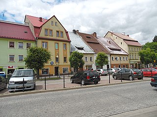
Międzylesie is a town in Kłodzko County, Lower Silesian Voivodeship, in south-western Poland. It is the seat of the administrative district (gmina) called Gmina Międzylesie, close to the Czech border. It lies approximately 33 kilometres (21 mi) south of Kłodzko, and 112 kilometres (70 mi) south of the regional capital Wrocław.

Owsianka is a village in the administrative district of Gmina Kobierzyce, within Wrocław County, Lower Silesian Voivodeship, in south-western Poland. Prior to 1945 it was in Germany. It lies approximately 4 kilometres (2 mi) west of Kobierzyce and 21 km (13 mi) south-west of the regional capital Wrocław.

Karczowice is a village in the administrative district of Gmina Ciepłowody, within Ząbkowice Śląskie County, Lower Silesian Voivodeship, in south-western Poland. Prior to 1945 it was in Germany.
Kobło-Kolonia is a village in the administrative district of Gmina Horodło, within Hrubieszów County, Lublin Voivodeship, in eastern Poland, close to the border with Ukraine.
Kuryły is a village in the administrative district of Gmina Michałowo, within Białystok County, Podlaskie Voivodeship, in north-eastern Poland, close to the border with Belarus.

Yarəhmədli is a village in the Jabrayil Rayon of Azerbaijan.

Qarıqışlaq is a village in the Lachin Rayon of Azerbaijan.

Yeni Qazma is a village in the Khachmaz Rayon of Azerbaijan.

Bąki is a village in the administrative district of Gmina Zadzim, within Poddębice County, Łódź Voivodeship, in central Poland. It lies approximately 9 kilometres (6 mi) east of Zadzim, 15 km (9 mi) south of Poddębice, and 34 km (21 mi) west of the regional capital Łódź.

Olszówka is a village in the administrative district of Gmina Łopuszno, within Kielce County, Świętokrzyskie Voivodeship, in south-central Poland. It lies approximately 4 kilometres (2 mi) north-east of Łopuszno and 26 km (16 mi) north-west of the regional capital Kielce.

Nadole is a village in the administrative district of Gmina Dukla, within Krosno County, Subcarpathian Voivodeship, in south-eastern Poland, close to the border with Slovakia. It lies approximately 2 kilometres (1 mi) south-west of Dukla, 16 km (10 mi) south-west of Krosno, and 59 km (37 mi) south-west of the regional capital Rzeszów.
Julin is a settlement in the administrative district of Gmina Iława, within Iława County, Warmian-Masurian Voivodeship, in northern Poland.
Košátky is a village and municipality in Mladá Boleslav District in the Central Bohemian Region of the Czech Republic.
The Hohe Warte is a hill in Bavaria, Germany.

Žabokvica is a village in the municipality of Srebrenica, Bosnia and Herzegovina.
Uulutilaid is a small islet positioned just off the coast of Virtsu Peninsula in the Baltic Sea belonging to the country of Estonia.
Oosäär is a small islet in the Gulf of Riga, belonging to Estonia.


