Steimbke

Last updated
Steimbke
Wappen Steimbke.png
Coat of arms
Germany adm location map.svg
Red pog.svg
Steimbke
Location of Steimbke within Nienburg/Weser district
Steinhuder MeerNorth Rhine-WestphaliaDiepholz (district)Oldenburg (district)SchaumburgHeidekreisVerden (district)Hanover (district)BalgeBinnenBinnenBinnenBinnenBückenDiepenauDrakenburgEstorfEystrupEystrupGandesbergenHämelhausenHämelhausenHaßbergenHaßbergenHassel (Weser)Hassel (Weser)HeemsenHilgermissenHoyaHoyerhagenHusumLandesbergenLeeseLiebenauLinsburgLinsburgMarkloheNienburgPennigsehlRaddestorfRehburg-LoccumRodewaldRohrsenSchweringenSteimbkeSteyerbergSteyerbergStöckseStolzenauUchteWarmsenWietzenWarpeSteimbke
Steimbke
Coordinates: 52°39′44″N9°24′15″E / 52.66222°N 9.40417°E / 52.66222; 9.40417 Coordinates: 52°39′44″N9°24′15″E / 52.66222°N 9.40417°E / 52.66222; 9.40417
Country Germany
State Lower Saxony
District Nienburg/Weser
Municipal assoc. Steimbke
Government
   Mayor Friedrich Andermann (CDU)
Area
  Total 63.06 km2 (24.35 sq mi)
Elevation 51 m (167 ft)
Population (2016-12-31) [1]
  Total 2,483
  Density 39/km2 (100/sq mi)
Time zone CET/CEST (UTC+1/+2)
Postal codes 31634
Dialling codes 05026
Vehicle registration NI
Website www.steimbke.de
Steimbke
town hall square and church Steimbkeo1.jpg
Steimbke
town hall square and church

Steimbke is a municipality in the district Nienburg, in Lower Saxony, Germany. It is situated approximately 12 km east of Nienburg, and 40 km northwest of Hanover, in a swamp and heathland, whereas the Blindesee takes centre stage.

Nienburg (district) District in Lower Saxony, Germany

Nienburg is a district (Landkreis) in Lower Saxony, Germany. It is bounded by the districts of Diepholz, Verden, Heidekreis, Hanover and Schaumburg, and by the state of North Rhine-Westphalia.

Lower Saxony State in Germany

Lower Saxony is a German state (Land) situated in northwestern Germany. It is the second-largest state by land area, with 47,624 km2 (18,388 sq mi), and fourth-largest in population among the 16 Länder federated as the Federal Republic of Germany. In rural areas, Northern Low Saxon and Saterland Frisian are still spoken, but the number of speakers is declining.

Germany Federal parliamentary republic in central-western Europe

Germany, officially the Federal Republic of Germany, is a country in Central and Western Europe, lying between the Baltic and North Seas to the north, and the Alps to the south. It borders Denmark to the north, Poland and the Czech Republic to the east, Austria and Switzerland to the south, France to the southwest, and Luxembourg, Belgium and the Netherlands to the west.

Contents

Policy

Municipality of Steimbke

The villages Steimbke, Wendenborstel, Glashof, Eckelshof, Lichtenhorst, Lichtenmoor, and Sonnenborstel comprise the municipality of Steimbke. Steimbke is also the seat of the ("collective municipality") Steimbke.

Steimbke is a Samtgemeinde in the district of Nienburg, in Lower Saxony, Germany. Its seat is in the village Steimbke.

Municipal council

The municipal council Steimbke has 12 members elected and a mayor elected directly. Since the local election on 10 September 2006, two parties and one Wählergemeinschaft represent it.

In many countries, a mayor is the highest-ranking official in a municipal government such as that of a city or a town.

History

Thirty Years War War between 1618 and 1648; with over 8 million fatalities

The Thirty Years' War was a war fought primarily in Central Europe between 1618 and 1648. One of the most destructive conflicts in human history, it resulted in eight million fatalities not only from military engagements but also from violence, famine, and plague. Casualties were overwhelmingly and disproportionately inhabitants of the Holy Roman Empire, most of the rest being battle deaths from various foreign armies. In terms of proportional German casualties and destruction, it was surpassed only by the period January to May 1945; one of its enduring results was 19th-century Pan-Germanism, when it served as an example of the dangers of a divided Germany and became a key justification for the 1871 creation of the German Empire.

Johann Tserclaes, Count of Tilly austrian general

Johann Tserclaes, Count of Tilly was a field marshal who commanded the Catholic League's forces in the Thirty Years' War. From 1620–1631 he had an unmatched string of important victories against the Protestants, including White Mountain, Wimpfen, Höchst, Stadtlohn and the Conquest of the Palatinate. He destroyed a Danish army at Lutter and sacked the city of Magdeburg but was then crushed at Breitenfeld in 1631 by the Swedish army of King Gustavus Adolphus. A Swedish cannonball took his life at Rain. Along with Duke Albrecht von Wallenstein of Friedland and Mecklenburg, he was one of two chief commanders of the Holy Roman Empire’s forces in the first half of the war.

In development of the village, the industrial union "Gewerkschaft Brigitta" had the greatest share in 1934 by beginning oil production. "Brigitta" established an estate for industrial workers with bounteous sports facilities, a stadion with flood light and an indoor- as well as an outdoor swimming pool. In the meantime, the reduction of oil production has resulted to the abolishment of the pumpjacks that in former times have been Steimbke's landmark. As of 30 June 2005, Steimbke had a population of 2.739.

Pumpjack

A pumpjack is the overground drive for a reciprocating piston pump in an oil well.

Landmark Recognizable natural or artificial feature used for navigation

A landmark is a recognizable natural or artificial feature used for navigation, a feature that stands out from its near environment and is often visible from long distances.

Population All the organisms of a given species that live in the specified region

In biology, a population is all the organisms of the same group or species, which live in a particular geographical area, and have the capability of interbreeding. The area of a sexual population is the area where inter-breeding is potentially possible between any pair within the area, and where the probability of interbreeding is greater than the probability of cross-breeding with individuals from other areas.

Related Research Articles

Schaumburg District in Lower Saxony, Germany

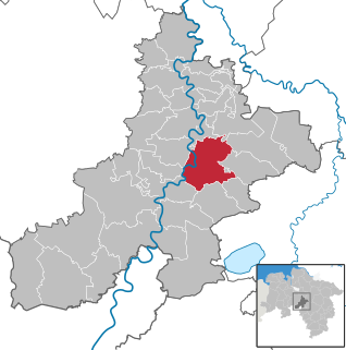
Schaumburg is a district (Landkreis) of Lower Saxony, Germany. It is bounded by the districts of Nienburg, Hanover and Hamelin-Pyrmont, and the state of North Rhine-Westphalia.

Prahova County County in Sud, Romania

Prahova County is a county (județ) of Romania, in the historical region Muntenia, with the capital city at Ploiești.

Široki Brijeg City in Federation of Bosnia and Herzegovina, Bosnia and Herzegovina

Široki Brijeg is a city and the administrative center of West Herzegovina Canton of the Federation of Bosnia and Herzegovina, an entity of Bosnia and Herzegovina. As of 2013, it had a population of 29,809.

Nienburg, Lower Saxony Place in Lower Saxony, Germany

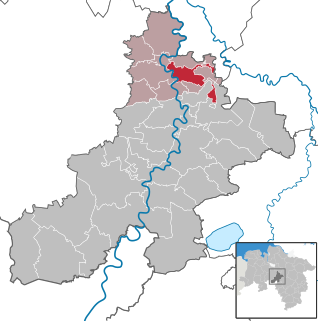
Nienburg is a town and capital of the district Nienburg, in Lower Saxony, Germany.

Schwarmstedt Place in Lower Saxony, Germany

Schwarmstedt is a municipality in the Heidekreis in Lower Saxony, Germany. It is situated near the confluence of the rivers Aller and Leine, approx. 20 km south of Bad Fallingbostel, and 30 km east of Nienburg. Further districts of the municipality are

Kuçovë Municipality in Berat, Albania

Kuçovë is a municipality in lower-central Albania. It was formed at the 2015 local government reform by the merger of the former municipalities Kozare, Kuçovë, Lumas and Perondi, that became municipal units. The seat of the municipality is the town Kuçovë. The total population is 31,262, in a total area of 160.23 km2. The population of the former municipality at the 2011 census was 12,654.

Siedenburg Place in Lower Saxony, Germany

Siedenburg is a municipality in the district of Diepholz, in Lower Saxony, Germany. It is situated approximately 20 km west of Nienburg.

Eystrup Place in Lower Saxony, Germany

Eystrup is a municipality in the district of Nienburg, in Lower Saxony, Germany. It is situated on the right bank of the Weser, approx. 15 km north of Nienburg, and 15 km south of Verden. Eystrup was the seat of the former Samtgemeinde Eystrup.

Hoya, Germany Place in Lower Saxony, Germany

Hoya is a town in the District of Nienburg, in Lower Saxony, Germany. It is situated on the left and right bank of the Weser, approx. 20 km north of Nienburg, and 15 km southwest of Verden.

Landesbergen Place in Lower Saxony, Germany

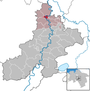
Landesbergen is a municipality in the district of Nienburg, in Lower Saxony, Germany. It is situated on the right bank of the Weser, approx. 10 km southwest of Nienburg, and 35 km northeast of Minden.

Liebenau, Lower Saxony Place in Lower Saxony, Germany

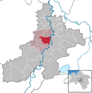
Liebenau is a municipality in the district of Nienburg, in Lower Saxony, Germany. It is situated on the left bank of the Weser, approx. 10 km southwest of Nienburg, and 40 km northeast of Minden.

Marklohe Place in Lower Saxony, Germany

Marklohe is a municipality in Lower Saxony, Germany.

Uchte Place in Lower Saxony, Germany

Uchte is a municipality in the district of Nienburg, in Lower Saxony, Germany. It is situated approximately 25 km southwest of Nienburg, and 25 km north of Minden.

Stöckse Place in Lower Saxony, Germany

Stöckse is a municipality in the district of Nienburg, in Lower Saxony, Germany. It is situated in the forest "Krähe" between Langendamm and Steimbke.

Waskada Former village in Manitoba, Canada

Waskada is an unincorporated urban community in the Municipality of Brenda – Waskada within the Canadian province of Manitoba that held village status prior to January 1, 2015. It is located in the southwest corner of the province, close to the United States and Saskatchewan borders. It was settled as early as 1883 and incorporated as a village in 1948. Waskada has a population of 183, and covers a land area of 0.77 km2. Though traditionally a farming community, a recent oil boom has also brought economic activity to the area.

Balge Place in Lower Saxony, Germany

Balge is a municipality in the district of Nienburg, in Lower Saxony, Germany, located on the Weser river. The community belongs to the Marklohe which consists of seven municipalities including Balge.

Rodewald Place in Lower Saxony, Germany

Rodewald is an agricultural village in the district of Nienburg, Lower Saxony and is locally administrated by Steimbke. At 14 kilometres in length, Rodewald is considered the second longest village in Lower Saxony, Germany and is split into three farming communities or peasantries, known simply as; Lower, Middle and Upper Farming Community.

Bundesstraße 214 federal highway in Germany

The Bundesstraße 214 is a federal road that runs from Lingen to Brunswick in North Germany.

Maik Beermann German politician

Maik Beermann is a German politician (CDU). He was elected to the 18th German Bundestag at federal election 2013.

References