
Jackson County is a county in the U.S. state of Oregon. As of the 2010 census, the population was 203,206. The county seat is Medford. The county is named for Andrew Jackson, the seventh president of the United States.

The Rock River is a tributary of the Mississippi River, approximately 299 miles (481 km) long, in the U.S. states of Wisconsin and Illinois. The river was known as the Sinnissippi to Sauk and Fox Indians; the name means "rocky waters".

Prospect State Scenic Viewpoint, is a state park south of the community of Prospect on Oregon Route 62 in Jackson County, in the U.S. state of Oregon. It was formerly known as Mill Creek Falls Scenic Area, a private hiking area that was developed by Willamette Industries along the Rogue River. Both Mill Creek Falls and Pearsony Falls are contained within the area, with Barr Creek Falls close by.

Lake Creek is an unincorporated community about 20 miles (32 km) east of Medford, in Jackson County, Oregon, United States. The community takes its name from Lake Creek, an important local stream.

Williams is an unincorporated community and census-designated place (CDP) in Josephine County, Oregon, United States. As of the 2010 census it had a population of 1,072.
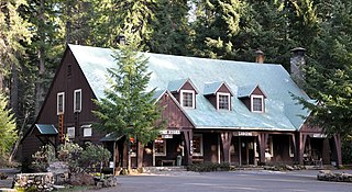
Union Creek is an unincorporated community in Jackson County in the U.S. state of Oregon. It is located along Union Creek and Oregon Route 62, about 15 miles (24 km) from Crater Lake National Park. The community is home to the Union Creek Historic District, which has been listed on the National Register of Historic Places since 1980.
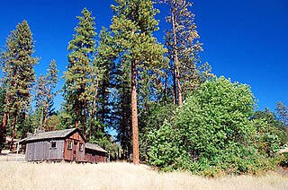
Buncom is an abandoned mining town at the confluence of the Little Applegate River and Sterling Creek in Jackson County, Oregon, United States. It is approximately 20 miles (32 km) southwest of Medford, at an elevation of 1,683 feet (513.0 m) above sea level. The site is promoted by the local historical society as a ghost town.

Sterlingville was a boomtown along on Sterling Creek in Jackson County, Oregon, United States, once home to the largest hydraulic mine in Oregon. It has since been abandoned and destroyed.
Foots Creek is an unincorporated community and census-designated place (CDP) in Jackson County, in the U.S. state of Oregon. It lies along Oregon Route 99 near the mouth of Foots Creek, where it empties into the Rogue River. Interstate 5 and Valley of the Rogue State Park are on the side of the river opposite Foots Creek.
Butte Falls is a waterfall located near the town of Butte Falls in Jackson County, in the U.S. state of Oregon. In the past, the waterfall was the site of a water-driven sawmill that led to the settlement of the town of Butte Falls.
Abbott Creek is a stream in the U.S. state of Oregon. It is a tributary to the Rogue River.
Battle Creek is a stream in the U.S. state of Oregon. It is a tributary to Evans Creek.
Bieberstedt Creek is a stream in the U.S. state of Oregon. It empties into Willow Lake.
Coalmine Creek is a stream in the U.S. state of Oregon. It is a tributary to Sugarpine Creek.
Coleman Creek is a stream in the U.S. state of Oregon. It is a tributary to Bear Creek.
Gore Creek is a stream in the U.S. state of Oregon. It is a tributary to Bear Creek.
Pleasant Creek is a stream in the U.S. state of Oregon. It is a tributary to Evans Creek.
Railroad Gap Creek is a stream in the U.S. state of Oregon. It is a tributary to Evans Creek.
Rancheria Creek is a stream in the U.S. state of Oregon. It is a tributary to South Fork Big Butte Creek.
Skeeters Creek is a stream in the U.S. state of Oregon.


