Stoddard, Wisconsin

Last updated

Stoddard, Wisconsin
Stoddard, Wisconsin.jpg
Vernon County Wisconsin Incorporated and Unincorporated areas Stoddard Highlighted.svg
Location of Stoddard in Vernon County, Wisconsin.
Coordinates: 43°39′46″N91°13′11″W / 43.66278°N 91.21972°W / 43.66278; -91.21972
Country Flag of the United States.svg  United States
State Flag of Wisconsin.svg  Wisconsin
County Vernon
Area
[1]
  Total0.71 sq mi (1.84 km2)
  Land0.64 sq mi (1.65 km2)
  Water0.07 sq mi (0.19 km2)
Elevation
[2]
659 ft (201 m)
Population
 (2020) [3]
  Total840
  Density1,302.98/sq mi (502.72/km2)
Time zone UTC-6 (Central (CST))
  Summer (DST) UTC-5 (CDT)
ZIP code
54658
Area code 608
FIPS code 55-77550 [4]
GNIS feature ID1574912 [2]
Website www.mwt.net/~stod/

Stoddard is a village in Vernon County, Wisconsin, United States. The population was 840 at the 2020 census.

Contents

History

Stoddard was founded as a farming community. It is notable as one of the few communities along the Mississippi River that was never a trading post or a riverboat stop. The river was originally one mile west of Stoddard, but when Lock and Dam No. 8 was built in 1937, the ensuing lake flooded the lowlands, literally bringing the river to the town. [5]

Geography

Stoddard is located at 43°39′46″N91°13′11″W / 43.66278°N 91.21972°W / 43.66278; -91.21972 (43.662889, -91.219745). [6]

According to the United States Census Bureau, the village has a total area of 0.79 square miles (2.05 km2), of which, 0.69 square miles (1.79 km2) of it is land and 0.10 square miles (0.26 km2) is water. [7]

Demographics

Historical population
CensusPop.Note
1910 343
1920 305−11.1%
1930 3163.6%
1940 36816.5%
1950 45924.7%
1960 55220.3%
1970 75035.9%
1980 7621.6%
1990 7751.7%
2000 8155.2%
2010 774−5.0%
2020 8408.5%
U.S. Decennial Census [8]

2010 census

As of the census [3] of 2010, there were 774 people, 335 households, and 221 families living in the village. The population density was 1,121.7 inhabitants per square mile (433.1/km2). There were 388 housing units at an average density of 562.3 per square mile (217.1/km2). The racial makeup of the village was 98.7% White, 0.6% African American, 0.1% Native American, 0.1% Asian, 0.1% from other races, and 0.3% from two or more races. Hispanic or Latino of any race were 0.8% of the population.

There were 335 households, of which 31.3% had children under the age of 18 living with them, 51.9% were married couples living together, 9.9% had a female householder with no husband present, 4.2% had a male householder with no wife present, and 34.0% were non-families. 28.4% of all households were made up of individuals, and 14.6% had someone living alone who was 65 years of age or older. The average household size was 2.31 and the average family size was 2.78.

The median age in the village was 40.6 years. 23.8% of residents were under the age of 18; 4.7% were between the ages of 18 and 24; 26.8% were from 25 to 44; 27.6% were from 45 to 64; and 17.2% were 65 years of age or older. The gender makeup of the village was 48.1% male and 51.9% female.

2000 census

As of the census [4] of 2000, there were 815 people, 351 households, and 226 families living in the village. The population density was 1,360.5 people per square mile (524.5/km2). There were 375 housing units at an average density of 626.0 per square mile (241.3/km2). The racial makeup of the village was 99.14% White, 0.12% Native American, 0.12% Asian, and 0.61% from two or more races. Hispanic or Latino of any race were 0.12% of the population.

There were 351 households, out of which 28.5% had children under the age of 18 living with them, 53.0% were married couples living together, 7.7% had a female householder with no husband present, and 35.6% were non-families. 28.8% of all households were made up of individuals, and 15.4% had someone living alone who was 65 years of age or older. The average household size was 2.32 and the average family size was 2.84.

In the village, the population was spread out, with 22.6% under the age of 18, 6.9% from 18 to 24, 30.4% from 25 to 44, 21.8% from 45 to 64, and 18.3% who were 65 years of age or older. The median age was 39 years. For every 100 females, there were 95.0 males. For every 100 females age 18 and over, there were 91.2 males.

The median income for a household in the village was $31,250, and the median income for a family was $39,250. Males had a median income of $30,972 versus $21,319 for females. The per capita income for the village was $19,634. About 4.4% of families and 9.3% of the population were below the poverty line, including 13.8% of those under age 18 and 12.7% of those age 65 or over.

Education

The De Soto Area Schools serve Stoddard.

St. Matthew's Lutheran School is a grade school of the Wisconsin Evangelical Lutheran Synod in Stoddard. Families from the church as well as from throughout the community attend. The school has four teachers, two pastors and four classrooms. St. Matthew's Preschool Program is available for children ages 3 and 4. The rest of the school serves grades K-8. Enrollment was 42 students as of 2019. [9] St. Matthew's Panther Sports Camp began in 2017 and serves families from the church and the larger community each June. [10]

Transportation

Bus service towards La Crosse or Prairie du Chien is provided three times daily per direction by Scenic Mississippi Regional Transit. [11]

Notable people

Images

Related Research Articles

<span class="mw-page-title-main">Tenakee Springs, Alaska</span> City in Alaska, United States

Tenakee Springs is a city on Chichagof Island in Hoonah-Angoon Census Area, Alaska, United States. At the 2010 census the population was 131, up from 104 at the 2000 census.

<span class="mw-page-title-main">Campbell Hill, Illinois</span> Village in Illinois, United States

Campbell Hill is a village in Jackson County, Illinois, United States. The population was 309 at the 2020 census.

<span class="mw-page-title-main">Stevensville, Michigan</span> Village in Michigan, United States

Stevensville is a village in Berrien County in the U.S. state of Michigan. The village lies within Lincoln Township. The population was 1,147 at the 2020 census.

<span class="mw-page-title-main">Frohna, Missouri</span> Village in Missouri, United States

Frohna is a city in Perry County, Missouri, United States. The population was 245 at the 2020 census.

<span class="mw-page-title-main">Bell City, Missouri</span> City in Missouri, United States

Bell City is a city in northeastern Stoddard County, Missouri, United States. It was founded as a sawmill town circa 1900, and lies at the foothills of Crowley's Ridge on Missouri Route 91. The population was 448 at the 2010 census. Dorothy Burton is the current mayor.

<span class="mw-page-title-main">Penermon, Missouri</span> Village in Missouri, United States

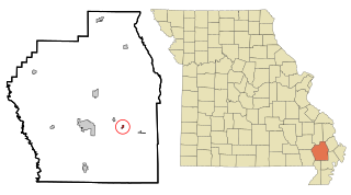
Penermon is a village in Stoddard County, Missouri, United States. The population was 64 at the 2010 census.

<span class="mw-page-title-main">Plymouth, Nebraska</span> Village in Nebraska, United States

Plymouth is a village in Jefferson County, Nebraska, United States. The population was 363 at the 2020 census.

Napi Headquarters is a census-designated place (CDP) in San Juan County, New Mexico, United States. The population was 706 at the 2000 census.

<span class="mw-page-title-main">Floyd, New York</span> Town in New York, United States

Floyd is a town in Oneida County, New York, United States. The population was 3,819 at the 2010 census. The town is named after William Floyd, a signer of the Declaration of Independence.

<span class="mw-page-title-main">Pardeeville, Wisconsin</span> Village in Wisconsin, United States

Pardeeville is a village in Columbia County, Wisconsin, United States. The population was 2,115 at the 2010 census. It is part of the Madison Metropolitan Statistical Area.

<span class="mw-page-title-main">Iron Ridge, Wisconsin</span> Village in Wisconsin, United States

Iron Ridge is a village in Dodge County, Wisconsin, United States. The population was 929 at the 2010 census. The village was founded on a railroad line, named for the iron mined in the area. Its ZIP code is 53035.

<span class="mw-page-title-main">North Fond du Lac, Wisconsin</span> Village in Wisconsin, United States

North Fond du Lac is a village in Fond du Lac County, Wisconsin, United States. The population was 5,378 at the 2020 census. Despite the name, North Fond du Lac is actually located northwest of Fond du Lac, as Lake Winnebago is directly north of Fond du Lac.

<span class="mw-page-title-main">West Salem, Wisconsin</span> Village in Wisconsin, United States

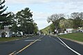
West Salem is a village in La Crosse County, Wisconsin, United States, along the La Crosse River. It is part of the La Crosse-Onalaska, WI-MN Metropolitan Statistical Area. The population was 4,799 as of the 2010 Census.

<span class="mw-page-title-main">Maribel, Wisconsin</span> Village in Wisconsin, United States

Maribel is a village in Manitowoc County, Wisconsin, United States. The population was 351 at the 2010 census.

<span class="mw-page-title-main">Hales Corners, Wisconsin</span> Village in Wisconsin, United States

Hales Corners is a village in Milwaukee County, Wisconsin, United States. The population was 7,720 at the 2020 census.

<span class="mw-page-title-main">North Bay, Wisconsin</span> Village in Wisconsin, United States

North Bay is a village in Racine County, Wisconsin, United States. The population was 209 at the 2020 census.

<span class="mw-page-title-main">De Soto, Wisconsin</span> Village in Wisconsin, United States

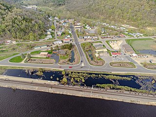
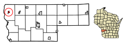
De Soto is a village mostly in Vernon County but also in Crawford County in Wisconsin. The population was 287 at the 2010 census. Of this, 179 were in living in Vernon County, and 108 were living in Crawford County. The downtown and business area is located in Crawford County.

<span class="mw-page-title-main">Cross Plains (town), Wisconsin</span>

Cross Plains is a town in Dane County, Wisconsin, United States. The population was 1,419 at the 2000 census. The Village of Cross Plains is located partially within the town. The unincorporated community of Pine Bluff is located in the town.

<span class="mw-page-title-main">Colfax, Wisconsin</span> Village in Wisconsin, United States

Colfax is a village in Dunn County, Wisconsin, United States. The population was 1,158 at the 2010 census. The village is surrounded by the Town of Colfax.

<span class="mw-page-title-main">Marquette, Wisconsin</span> Village in Wisconsin, United States

Marquette is a village in Green Lake County, Wisconsin, United States. The population was 150 at the 2010 census. The village is located within the Town of Marquette. Marquette uses the postal code 53947.

References

  1. "2019 U.S. Gazetteer Files". United States Census Bureau. Retrieved August 7, 2020.
  2. 1 2 "US Board on Geographic Names". United States Geological Survey. October 25, 2007. Retrieved January 31, 2008.
  3. 1 2 "U.S. Census website". United States Census Bureau . Retrieved November 18, 2012.
  4. 1 2 "U.S. Census website". United States Census Bureau . Retrieved January 31, 2008.
  5. "New Page 1".
  6. "US Gazetteer files: 2010, 2000, and 1990". United States Census Bureau. February 12, 2011. Retrieved April 23, 2011.
  7. "US Gazetteer files 2010". United States Census Bureau. Archived from the original on January 12, 2012. Retrieved November 18, 2012.
  8. "Census of Population and Housing". Census.gov. Retrieved February 15, 2023.
  9. "St. Matthew's Lutheran School". St. Matthew's Lutheran School. July 3, 2019. Retrieved July 5, 2019.
  10. Kosirowski, Ken (June 20, 2019). "Youth basketball, soccer camp bringing Stoddard community together". WKBT. Retrieved July 5, 2019.
  11. Bus schedule ridesmrt.com [ dead link ]