Troms is a county in northern Norway. On 1 January 2020 it was merged with the neighboring Finnmark county to create the new Troms og Finnmark county. This merger was reversed by the government resulting from the 2021 Norwegian parliamentary election on 1 January 2024.

Skjervøy kommune is a municipality in Troms county, Norway. The administrative centre of the municipality is the town of Skjervøy on the island of Skjervøya, where most of the inhabitants live. The main industries are fishing and shipbuilding.

Nordreisa is a municipality in Troms county, Norway. The administrative centre of the municipality is the village of Storslett. Other villages include Oksfjordhamn, Sørkjosen, and Rotsund.

Enontekiö is a municipality in the Finnish part of Lapland with approx. 1,800 inhabitants. It is situated in the outermost northwest of the country and occupies a large and very sparsely populated area of about 8,400 square kilometres (3,200 sq mi) between the Swedish and Norwegian border. Finland's highest point, the Halti fell, with a height of 1,324 metres (4,344 ft) above the mean sea level, is situated in the north of Enontekiö. The municipality shares borders with regions of Sweden and Norway that encompass the Scandinavian Mountains. The administrative centre of Enontekiö is the village of Hetta. About one fifth of the community's population are Sami people. Enontekiö's main industries are tourism and reindeer husbandry.
is a town in Rauma Municipality in Møre og Romsdal county, Norway. Åndalsnes is in the administrative center of Rauma Municipality. It is located along the Isfjorden, at the mouth of the river Rauma, at the north end of the Romsdalen valley. The village of Isfjorden lies about 7 kilometres (4.3 mi) to the east, Veblungsnes lies just to the west across the Rauma, and Innfjorden lies about 10 kilometres (6.2 mi) to the southwest via the European Route E136 highway.

Korgen is the administrative centre of Hemnes Municipality in Nordland county, Norway. The village located along the river Røssåga, about 8 kilometres (5.0 mi) south of the village of Bjerka. Korgen is connected by the European route E6 highway to the nearby towns of Mo i Rana and Mosjøen. The eastern end of the Korgfjell Tunnel is located in Korgen. The village of Bleikvassli lies about 20 kilometres (12 mi) to the south along the Norwegian County Road 806. The 0.9-square-kilometre (220-acre) village has a population (2017) of 878 which gives the village a population density of 976 inhabitants per square kilometre (2,530/sq mi). This makes it the largest urban area in the municipality.

Storsteinnes is the administrative center of Balsfjord Municipality in Troms county, Norway. The 1.1-square-kilometre (270-acre) village has a population (2017) of 1,076 which gives the village a population density of 978 inhabitants per square kilometre (2,530/sq mi). This makes it the largest urban area in the municipality. Storsteinnes Chapel is located in this village.

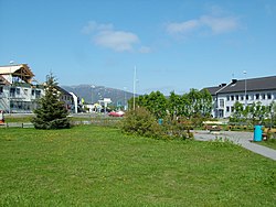
Nordkjosbotn (Norwegian) or Gárgán (Northern Sami) is a small village in Balsfjord Municipality in Troms county, Norway. The village lies about 70 kilometres (43 mi) southeast of the city of Tromsø. Two major highways, European route E6 and European route E8, meet in this village, making it a major crossroads in Northern Norway, with an estimated annual passage of 3 million people. The 0.7-square-kilometre (170-acre) village has a population (2017) of 464 which gives the village a population density of 663 inhabitants per square kilometre (1,720/sq mi). Nordkjosbotn Church is located in this village. Macks Ølbryggeri, a brewery, has been operating in Nordkjosbotn since 2012.

Eidsvåg is a village in Molde Municipality in Møre og Romsdal county, Norway. The village is located at the end of the Langfjorden on the isthmus connecting the Romsdal peninsula to the Norwegian mainland. It is located about 8.5 kilometres (5.3 mi) southwest of the village of Raudsand, about 20 kilometres (12 mi) north of the village of Eresfjord, and 9 kilometres (5.6 mi) north of the village of Boggestranda. Nesset Church is located in this village. The village is home to some mechanical industries.

Setermoen is the administrative centre of Bardu Municipality in Troms county, Norway. The village is located along the Barduelva river, about 25 kilometres (16 mi) east of the village of Sjøvegan and about 25 kilometres (16 mi) south of Bardufoss.

Sjøvegan is the administrative centre of Salangen Municipality in Troms county, Norway. The village is located at the end of the Sagfjorden, a branch of the Salangen fjord. The river Salangselva empties into the fjord at Sjøvegan. The river flows through the lakes Nervatnet and Øvrevatnet just to the east of the village.
Sørkjosen is a village in Nordreisa Municipality in Troms county, Norway. The village is located along the shores of the Reisafjorden about 5 kilometres (3.1 mi) northwest of the municipal center of Storslett. Sørkjosen has many industries including fishing, dairy production, and a sawmill.

Sørkjosen Airport is a regional airport located at the village of Sørkjosen in Nordreisa Municipality in Tromsk county, Norway, about 4.5 kilometres (2.8 mi) from the municipal center of Storslett. Owned and operated by the state-owned Avinor, it handled 15,198 passengers in 2014. The airport has a 880-meter (2,890 ft) runway and is served by Widerøe, which operates regional routes using the Dash 8-100 to Tromsø, and some communities and towns in Finnmark on public service obligation contracts. The airport opened in 1974 and was originally served using de Havilland Canada Twin Otter aircraft. Dash 8s were introduced in 1995 and two years later ownership was transferred from Nordreisa Municipality to the state.

Byglandsfjord is a village in Bygland municipality in Agder county, Norway. The village is located in the Setesdal valley along the Norwegian National Road 9 and the river Otra in the far southern part of the municipality, just north of the border with Evje og Hornnes municipality and at the southern end of the lake Byglandsfjorden. The 0.47-square-kilometre (120-acre) village has a population (2016) of 365 which gives the village a population density of 777 inhabitants per square kilometre (2,010/sq mi). Revsnes Hotel offers accommodation.

Hommelvik is the administrative centre of the municipality of Malvik in Trøndelag county, Norway. The village is located at the end of the Hommelvika, a bay off of the Trondheimsfjord. Hommelvik is about 2.5 kilometres (1.6 mi) southwest of the village of Muruvika, about 4 kilometres (2.5 mi) southeast of the village of Smiskaret, about 8 kilometres (5.0 mi) east of the village of Vikhammer, and about 10 kilometres (6.2 mi) north of the village of Sneisen. The river Homla runs north through the village, emptying into the fjord. The name of the village is derived from the river name.

Nordreisa Church is a parish church of the Church of Norway in Nordreisa Municipality in Troms county, Norway. It is located in the village of Storslett. It is one of the two churches for the Nordreisa parish which is part of the Nord-Troms prosti (deanery) in the Diocese of Nord-Hålogaland. The white, wooden church was built in a long church style in 1856 using plans drawn up by the architect Christian Heinrich Grosch. The church seats about 350 people.
Reisafjorden (Norwegian), Ráisavuotna (Northern Sami), or Raisinvuono (Kven) is a fjord in Troms county, Norway. It is located mostly in Nordreisa Municipality. The 30-kilometre (19 mi) long fjord is an arm off the main Kvænangen fjord. The fjord is fed by the river Reisaelva which flows through the 80-kilometre (50 mi) long Reisadalen valley which starts inside Reisa National Park. The villages of Storslett and Sørkjosen are both located along the southern shore of the fjord. The European route E06 highway runs along the shore of the inner part of the fjord.
Rotsund or Rotsundelv is a village in Nordreisa Municipality in Troms og Finnmark county, Norway. The village is located along the Rotsundet strait, across from the island of Uløya. The village sits along the river Rotsundelva, along the European route E06 highway about 20 kilometres (12 mi) northwest of the municipal centre of Storslett. Rotsund Chapel is located in this village. On the western end of the village, there is a ferry port with regular ferry service to Hamnes and Klauvnes on the island of Uløya.

Vennesla is the administrative centre of Vennesla municipality in Agder county, Norway. The village is located in the upper Torridal valley along the river Otra, about 15 kilometres (9.3 mi) north of the city of Kristiansand. The village itself extends for about 10 kilometres (6.2 mi) along both sides of the river. The Norwegian National Road 9 passes through Mosby, about 6 kilometres (3.7 mi) south of Vennesla. The Sørlandsbanen railway line passes through Vennesla, stopping at Vennesla Station. The lake Venneslafjorden is located on the river Otra in the northern part of the village of Vennesla.