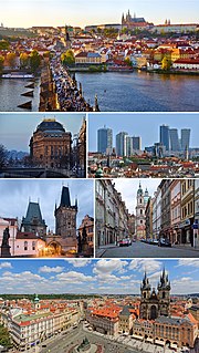
Hradčany, the Castle District, is the district of the city of Prague, Czech Republic surrounding Prague Castle.

Malá Strana or more formally Menší Město pražské is a district of the city of Prague, Czech Republic, and one of its most historic regions.

The Great Strahov Stadium is a stadium in the Strahov district of Prague, Czech Republic. It was built for displays of synchronized gymnastics on a massive scale, with a field three times as long as and three times as wide as than the standard Association football pitch. It has a capacity of 250,000 spectators, of which is 56,000 seating, making it the largest stadium and the second largest sports venue ever built.

Tehelné pole is a neighborhood in Bratislava, Slovakia, characterized by the presence of several sports facilities. Administratively, the neighborhood belongs to Nové Mesto borough, situated around 5 km north-east of the centre. The German and Hungarian names for this locality are Ziegelfeld and Téglamezö.

The Senate of the Parliament of the Czech Republic, usually referred to as Senate, is the upper chamber of the Parliament of the Czech Republic. The seat of the Senate is Wallenstein Palace in Prague.

Štvanice stadium was a sports stadium situated on Štvanice Island, Czech Republic and was ranked among the oldest stadiums in Prague. The stadium was in its heyday in the first half of the 20th Century, but has been in decline since 1961. It was here, where in 1947 the Czechoslovak national team won the Ice Hockey World Championship for the first time.

Stadion Evžena Rošického, also known simply as Strahov, is a multi-purpose stadium in Strahov, Prague in the Czech Republic. It hosted the 1978 European Athletics Championships and for many years this was the venue for main annual international athletic meet of Prague until Stadion Juliska took the role in 2002. Nowadays the stadium is used only for minor domestic athletic competitions and mostly for football matches, although no team plays at the stadium regularly. It served as the home ground for SK Slavia Prague from August 2000 until May 2008 when their new stadium, the Synot Tip Arena, was opened. It is also occasionally used by other Czech teams, and is the usual venue for the Czech Cup final. Currently, it is the home stadium of FK Olympia Prague of the Czech National Football League.
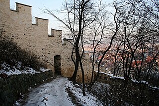
The Hunger Wall is a medieval defensive wall of the Lesser Town of Prague, today's Czech Republic. It was built on Petřín Hill between 1360 and 1362 by order of Charles IV.

Městský Stadium is a multi-purpose stadium in Mladá Boleslav, Czech Republic. It is currently used mostly for football matches and is the home ground of FK Mladá Boleslav. The stadium holds 5,000 people.

Sinobo Stadium is a football stadium, in Prague-Vršovice, Czech Republic.

Petřín is a hill in the center of Prague, Czech Republic. It rises 327 m above sea level and some 130 m above the left bank of the Vltava River. The hill, almost entirely covered with parks, is a favorite recreational area for the inhabitants of Prague. The hill is featured prominently in Franz Kafka's early short story "Description of a Struggle" and briefly in Milan Kundera's novel The Unbearable Lightness of Being.

Kampa is an island in the Vltava river in central Prague on the side of Malá Strana. Charles Bridge crosses its northern tip and is connected to the island by the street ulice Na Kampě. It is separated from Malá Strana by a narrow artificial channel to the west called the Devil's Stream (Čertovka), a waterway dug to power water mills. It is supposedly named after a sharp-tongued woman who lived in a local home called the Seven Devils.

The Embassy of France to the Czech Republic is located on Velkopřevorské náměstí, in Malá Strana, Prague, next to Vltava's island Kampa. It occupies the large baroque Buquoy Palace (1719). The ground floor of the Embassy was flooded during the August 2002 floods.
Stadion Eden, officially named Stadion Dr. Václava Vacka, was a multi-use stadium in Prague, Czech Republic. It was initially used as the stadium of Slavia Prague matches. It was replaced by the current Eden Arena in 2008. The original capacity of the stadium was 38,000 spectators, mostly standing terraces.
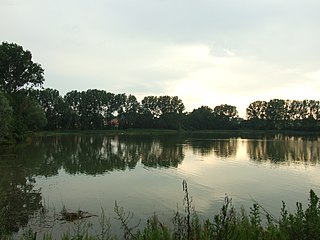
Chýně is a village and municipality in Prague-West District in the Central Bohemian Region of the Czech Republic. It lies 14 km west from the centre of Prague and 2 km from its edge near the suburb of Zličín. To the northeast is the town of Hostivice and the town of Rudná is to the southwest. The Litovický stream runs east along the northern border and forms two small ponds. The upper pond is called Basta, has a dam, and a small sandy beach added in 2008. The lower pond is called Strahov. The surrounding area is undulating and mostly farm land. The village has a small industrial area to the east, a rural core, and to the west is Haje, a newly settled area, which in 2010 is still partially under construction.

Saint Thomas Church is an Augustinian church in Malá Strana, Prague, Czech Republic. The address is at Josefská 8. The church was rebuilt in the 1720s in baroque style, and features a dome on top of the nave and a bell tower topped with slender spire on the front facade of this religious structure.

The Čertovka (Devil's Canal), sometimes also called Little Prague Venice in English, is a canal in Prague, the Czech Republic. It is situated in the Lesser Quarter. The Čertovka takes its water from the Vltava and after 740 m it flows back into that river. There are several medieval mills along its course. The canal was built probably in the 12th century by the Order of the Knights of Malta, who added a portion of land to the right and created an island called Kampa.

The Stolpersteine in Prague-Malá Strana lists the Stolpersteine in the town quarter Malá Strana of Prague. Stolpersteine is the German name for stumbling blocks collocated all over Europe by German artist Gunter Demnig. They remember the fate of the Nazi victims being murdered, deported, exiled or driven to suicide.

The Malá Strana Bridge Tower is located in Prague, Czech Republic. The tower serves as the entrance to Malá Strana from the Charles Bridge.