Straža pri Oplotnici

Last updated
Straža pri Oplotnici
Straža (until 1998)
Slovenia location map.svg
Red pog.svg
Straža pri Oplotnici
Location in Slovenia
Coordinates: 46°22′54.98″N15°28′25.02″E / 46.3819389°N 15.4736167°E / 46.3819389; 15.4736167 Coordinates: 46°22′54.98″N15°28′25.02″E / 46.3819389°N 15.4736167°E / 46.3819389; 15.4736167
Country Flag of Slovenia.svg Slovenia
Traditional region Styria
Statistical region Drava
Municipality Oplotnica
Area
  Total 0.81 km2 (0.31 sq mi)
Elevation 385 m (1,263 ft)
Population (2015) [1]
  Total 72

Straža pri Oplotnici (pronounced  [ˈstɾaːʒa pɾi ɔˈploːtnitsi] ) is a settlement in the Municipality of Oplotnica in eastern Slovenia. The area is part of the traditional region of Styria. The municipality is now included in the Drava Statistical Region. [2]

Oplotnica Town and Municipality in Slovenia

Oplotnica is a small town and municipality in eastern Slovenia. It lies on the Oplotniščica River, a left tributary of the Dravinja River, to the north of Slovenske Konjice. The area was part of the traditional region of Styria and formerly part of Austria-Hungary. The municipality is now included in the Drava Statistical Region.

Slovenia republic in Central Europe

Slovenia, officially the Republic of Slovenia, is a sovereign state located in southern Central Europe at a crossroads of important European cultural and trade routes. It is bordered by Italy to the west, Austria to the north, Hungary to the northeast, Croatia to the southeast, and the Adriatic Sea to the southwest. It covers 20,273 square kilometers (7,827 sq mi) and has a population of 2.07 million. One of the successor states of the former Yugoslavia, Slovenia is a parliamentary republic and a member of the United Nations, of the European Union, and of NATO. The capital and largest city is Ljubljana.

Drava Statistical Region Statistical region in 41

The Drava Statistical Region is a statistical region in Slovenia. The largest town in the region is Maribor. Its name comes from the Drava River and includes land on both banks along its course through Slovenia as well as the Pohorje mountains in the northeast of the region. The Drava is used for the production of hydroelectricity and the fertile land around it is used for agriculture. The share of job vacancies in all available jobs is among the highest in Slovenia and the region has a positive net migration rate but a very high natural decrease, which means an overall decrease in the population.

Contents

Name

The settlement was named Straža until 1998, when it was renamed Straža pri Oplotnici (literally, 'Straža near Oplotnica') to differentiate it from other settlements with the same name. [1] The name Straža is found in various toponyms, oronyms, and hydronyms in Slovenia. It is derived from the common noun straža 'guards, guard post', often referring to a place where watch was kept during the danger of Ottoman attacks. [3]

Toponymy is the study of place names (toponyms), their origins, meanings, use, and typology.

A hydronym is a proper name of a body of water. Hydronymy, a subset of toponymy, the taxonomic study of place-names, is the study of the names of bodies of water, the origins of those names, and how they are transmitted through history. Hydronyms may include the names of rivers (potamonyms), lakes, and even oceanic elements.

The Ottoman wars in Europe were a series of military conflicts between the Ottoman Empire and various European states dating from the Late Middle Ages up through the early 20th century. The earliest conflicts began during the Byzantine–Ottoman wars, waged in Anatolia in the late 13th century before entering Europe in the mid 14th century, followed by the Bulgarian–Ottoman wars and the Serbian–Ottoman wars waged beginning in the mid 14th century. Much of this period was characterized by Ottoman expansion into the Balkans. The Ottoman Empire made further inroads into Central Europe in the 15th and 16th centuries, culminating in the peak of Ottoman territorial claims in Europe.

History

The Roman road from Celeia to Poetovio led through the area, and parts of it are still traceable. [4]

Roman roads roads built in service of the Roman Empire

Roman roads were physical infrastructure vital to the maintenance and development of the Roman state, and were built from about 300 BC through the expansion and consolidation of the Roman Republic and the Roman Empire. They provided efficient means for the overland movement of armies, officials, and civilians, and the inland carriage of official communications and trade goods. Roman roads were of several kinds, ranging from small local roads to broad, long-distance highways built to connect cities, major towns and military bases. These major roads were often stone-paved and metaled, cambered for drainage, and were flanked by footpaths, bridleways and drainage ditches. They were laid along accurately surveyed courses, and some were cut through hills, or conducted over rivers and ravines on bridgework. Sections could be supported over marshy ground on rafted or piled foundations.

Celje Place in Slovenia

Celje is the third-largest town in Slovenia. It is a regional center of the traditional Slovenian region of Styria and the administrative seat of the City Municipality of Celje. The town of Celje is located below Upper Celje Castle at the confluence of the Savinja, Hudinja, Ložnica, and Voglajna rivers in the lower Savinja Valley, and at the crossing of the roads connecting Ljubljana, Maribor, Velenje, and the Central Sava Valley. It lies 238 m (781 ft) above mean sea level (MSL).

Ptuj City in Styria, Slovenia

Ptuj is a town in northeastern Slovenia that is the seat of the Municipality of Ptuj. Ptuj, the oldest recorded city in Slovenia, has been inhabited since the late Stone Age and developed from a Roman military fort. Ptuj was located at a strategically important crossing of the Drava River, along a prehistoric trade route between the Baltic Sea and the Adriatic. Traditionally the area was part of the Styria region and became part of the Austria-Hungarian Empire. In the early 20th century the majority of the residents were ethnic Germans, but today the population is largely Slovene. Residents of Ptuj are known as Ptujčani in Slovene.

Cultural Heritage

A small chapel with a wooden belfry was built in 1947. [5]

Chapel Religious place of fellowship attached to a larger institution

The term chapel usually refers to a Christian place of prayer and worship that is attached to a larger, often nonreligious institution or that is considered an extension of a primary religious institution. It may be part of a larger structure or complex, such as a college, hospital, palace, prison, funeral home, church, synagogue or mosque, located on board a military or commercial ship, or it may be an entirely free-standing building, sometimes with its own grounds. Chapel has also referred to independent or nonconformist places of worship in Great Britain—outside the established church.

Bell tower a tower that contains one or more bells, or that is designed to hold bells

A bell tower is a tower that contains one or more bells, or that is designed to hold bells even if it has none. Such a tower commonly serves as part of a church, and will contain church bells, but there are also many secular bell towers, often part of a municipal building, an educational establishment, or a tower built specifically to house a carillon. Church bell towers often incorporate clocks, and secular towers usually do, as a public service.

Related Research Articles

Šmarje pri Jelšah Town and Municipality in Slovenia

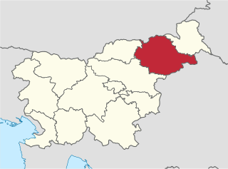
Šmarje pri Jelšah is a town and a municipality in eastern Slovenia. The area was part of the traditional region of Styria. The municipality is now included in the Savinja Statistical Region. The development of the settlement is associated with a medieval mansion known as Jelšingrad on a slight hill northwest of the town.

Leskovec pri Krškem Place in Lower Carniola, Slovenia

Leskovec pri Krškem is a settlement on the right bank of the Sava River in the Municipality of Krško in eastern Slovenia. The area was traditionally part of Lower Carniola. It is now included with the rest of the municipality in the Lower Sava Statistical Region. It includes the hamlets of Grad, Beli Breg, Veliki Marof, and Žadovinka. Older sources also mention the appertaining hamlet of Bajer.

Drenovec pri Leskovcu in Lower Carniola, Slovenia

Drenovec pri Leskovcu is a small settlement west of Leskovec pri Krškem in the Municipality of Krško in eastern Slovenia. The area was traditionally part of Lower Carniola. It is now included with the rest of the municipality in the Lower Sava Statistical Region.

Dunaj, Krško in Lower Carniola, Slovenia

Dunaj is a small settlement in the hills above the right bank of the Sava River in the Municipality of Krško in eastern Slovenia. The area was traditionally part of Lower Carniola. It is now included with the rest of the municipality in the Lower Sava Statistical Region.

Straža pri Raki in Lower Carniola, Slovenia

Straža pri Raki is a settlement east of Raka in the Municipality of Krško in eastern Slovenia. The area was traditionally part of Lower Carniola. It is now included with the rest of the municipality in the Lower Sava Statistical Region.

Kebelj in Styria, Slovenia

Kebelj is a village in the Municipality of Slovenska Bistrica in northeastern Slovenia. It lies in the Pohorje Hills, north of Oplotnica. The area is part of the traditional region of Styria. It is now included with the rest of the municipality in the Drava Statistical Region.

Kot na Pohorju Place in Styria, Slovenia

Kot na Pohorju is a dispersed settlement in the Municipality of Slovenska Bistrica in northeastern Slovenia. It lies in the Pohorje Hills north of Oplotnica. The area is part of the traditional region of Styria. It is now included with the rest of the municipality in the Drava Statistical Region.

Podvin pri Polzeli in Styria, Slovenia

Podvin pri Polzeli is a settlement on the left bank of the Savinja River in the Municipality of Polzela in Slovenia. The area is part of the traditional region of Styria. The municipality is now included in the Savinja Statistical Region.

Brezje pri Oplotnici in Styria, Slovenia

Brezje pri Oplotnici is a settlement in the Municipality of Oplotnica in eastern Slovenia. It lies in the hills between Oplotnica and Zreče. The area is part of the traditional region of Styria. The municipality is now included in the Drava Statistical Region.

Dobriška Vas in Styria, Slovenia

Dobriška Vas is a small village south of Oplotnica in eastern Slovenia. The area is part of the traditional region of Styria. The Municipality of Oplotnica is now included in the Drava Statistical Region.

Čadram in Styria, Slovenia

Čadram is a settlement in the municipality of Oplotnica in eastern Slovenia. It lies immediately east of Oplotnica itself. The area is part of the traditional region of Styria. The municipality is now included in the Drava Statistical Region.

Koritno, Oplotnica in Styria, Slovenia

Koritno is a settlement in the Municipality of Oplotnica in eastern Slovenia. It is dispersed on the southern slopes of the Pohorje range to the north of Oplotnica. The area is part of the traditional region of Styria. The municipality is now included in the Drava Statistical Region.

Malahorna in Styria, Slovenia

Malahorna is a village in the Municipality of Oplotnica in eastern Slovenia. The area is part of the traditional region of Styria. The municipality is now included in the Drava Statistical Region.

Pobrež in Styria, Slovenia

Pobrež is a settlement in the Municipality of Oplotnica in eastern Slovenia. It lies on the flatlands south of Oplotnica. Traditionally the entire area was part of the region of Styria. It is now included in the Drava Statistical Region.

Prihova, Oplotnica Place in Styria, Slovenia

Prihova is a settlement in the Municipality of Oplotnica in northeastern Slovenia. The area is part of the traditional region of Styria. The municipality is now included in the Drava Statistical Region.

Raskovec in Styria, Slovenia

Raskovec is a small settlement in the Municipality of Oplotnica in eastern Slovenia. It lies on Čadram Creek southeast of Oplotnica. The area is part of the traditional region of Styria. The municipality is now included in the Drava Statistical Region.

Ugovec in Styria, Slovenia

Ugovec is a settlement in the Municipality of Oplotnica in eastern Slovenia. The area is part of the traditional region of Styria. The municipality is now included in the Drava Statistical Region.

Lemberg pri Šmarju Place in Styria, Slovenia

Lemberg pri Šmarju is a settlement in the Municipality of Šmarje pri Jelšah in eastern Slovenia. It lies in the hills northeast of Šmarje. The area was traditionally part of Styria. The municipality is now included in the Savinja Statistical Region.

Planina pri Sevnici Place in Styria, Slovenia

Planina pri Sevnici is a village in the Municipality of Šentjur in eastern Slovenia. The area is part of the historical region of Styria. The municipality is now included in the Savinja Statistical Region.

References

  1. 1 2 Statistical Office of the Republic of Slovenia: Straža pri Oplotnici.
  2. Oplotnica municipal site
  3. Snoj, Marko. 2009. Etimološki slovar slovenskih zemljepisnih imen. Ljubljana: Modrijan and Založba ZRC, p. 398.
  4. Slovenian Ministry of Culture register of national heritage reference number ešd 6894
  5. Slovenian Ministry of Culture register of national heritage reference number ešd 20360