
A photograph is an image created by light falling on a photosensitive surface, usually photographic film or an electronic image sensor, such as a CCD or a CMOS chip. Most photographs are created using a camera, which uses a lens to focus the scene's visible wavelengths of light into a reproduction of what the human eye would see. The process and practice of creating such images is called photography. The word photograph was coined in 1839 by Sir John Herschel and is based on the Greek φῶς (phos), meaning "light," and γραφή (graphê), meaning "drawing, writing," together meaning "drawing with light."

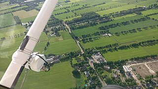
Kite aerial photography (KAP) is a hobby and a type of photography. A camera is lifted using a kite and is triggered either remotely or automatically to take aerial photographs. The camera rigs can range from the extremely simple, consisting of a trigger mechanism with a disposable camera, to complex apparatus using radio control and digital cameras. On some occasions it can be a good alternative to other forms of aerial photography.

Imagery intelligence (IMINT) is an intelligence gathering discipline which collects information via satellite and aerial photography. As a means of collecting intelligence, IMINT is a subset of intelligence collection management, which, in turn, is a subset of intelligence cycle management. IMINT is especially complemented by non-imaging MASINT electro-optical and radar sensors.
Black-and-white images combine black and white in a continuous spectrum, producing a range of shades of gray.
Panoramic photography is a technique of photography, using specialized equipment or software, that captures images with horizontally elongated fields of view. It is sometimes known as wide format photography. The term has also been applied to a photograph that is cropped to a relatively wide aspect ratio, like the familiar letterbox format in wide-screen video.

Photogrammetry is the art and science of making measurements from photographs, especially for recovering the exact positions of surface points. Photogrammetry is as old as modern photography, dating to the mid-19th century and in the simplest example, the distance between two points that lie on a plane parallel to the photographic image plane, can be determined by measuring their distance on the image, if the scale (s) of the image is known.

Aerial archaeology is the study of archaeological remains by examining them from altitude.

Macro photography, is extreme close-up photography, usually of very small subjects and living organisms like insects, in which the size of the subject in the photograph is greater than life size .
By the original definition, a macro photograph is one in which the size of the subject on the negative or image sensor is life size or greater. However, in some uses it refers to a finished photograph of a subject at greater than life size.
Aerial survey is a method of collecting geomatics or other imagery by using airplanes, helicopters, UAVs, balloons or other aerial methods. Typical types of data collected include aerial photography, Lidar, remote sensing and also geophysical data (such as aeromagnetic surveys and gravity. It can also refer to the chart or map made by analysing a region from the air. Aerial survey should be distinguished from satellite imagery technologies because of its better resolution, quality and atmospheric conditions. Today, aerial survey is sometimes recognized as a synonym for aerophotogrammetry, part of photogrammetry where the camera is placed in the air. Measurements on aerial images are provided by photogrammetric technologies and methods.

Satellite imagery are images of Earth or other planets collected by imaging satellites operated by governments and businesses around the world. Satellite imaging companies sell images by licensing them to governments and businesses such as Apple Maps and Google Maps.

A photo finish occurs in a sporting race when multiple competitors cross the finishing line at nearly the same time. As the naked eye may not be able to discriminate between which of the competitors crossed the line first, a photo or video taken at the finish line may be used for a more accurate check. Photo finishes make it less likely that officials will declare a race a dead heat.

Marilyn Christine Bridges is an American photographer noted for her fine art black and white aerial photographs of extraordinary ancient and modern landscapes. She has photographed sacred and secular sites in over 20 countries, including Peru, Mexico, France, Britain, Egypt, Greece, Turkey, Australia, Namibia, Indonesia and India. Bridges is a licensed pilot and a Fellow of the Explorers Club. She lives in New York.
The following outline is provided as an overview of and topical guide to photography:

George William Goddard was a United States Air Force brigadier general and a pioneer in aerial photography.

CU Spaceflight is a student-run Cambridge University society founded with the aim of achieving cheap access to space. It is supported by the Cambridge-MIT Institute.

Aerial reconnaissance is reconnaissance for a military or strategic purpose that is conducted using reconnaissance aircraft. This role can fulfil a variety of requirements, including the collection of imagery intelligence, observation of enemy maneuvers and artillery spotting.
Aerial reconnaissance using heavier-than-air machines was an entirely new science that had to be improvised step-by-step. Early operations were low-level flights with the pilot often dismounting from the plane to report verbally to the nearest officers. Photographic support was urgently developed, initially requiring a full-time photographer on board to handle the heavy, awkward equipment. The interpreting of aerial images was an important new speciality, essential for accurate mapping. By 1915, air-to-ground radio was in use for reconnaissance pilots.
Dronestagram is a photo sharing community dedicated to drone photography. The site that has been described as "Instagram for drones", allows hobbyists to share their geo-referenced aerial photos and videos. The site launched in July 2013 by Eric Dupin and is owned by his company Dronescape. The project is based in Lyon, France. There is also an dronestagram iOS app.

