Portuguese Mozambique or Portuguese East Africa were the common terms by which Mozambique was designated during the period in which it was a Portuguese colony. Portuguese Mozambique originally constituted a string of Portuguese possessions along the south-east African coast, and later became a unified colony, which now forms the Republic of Mozambique.
Korea's provinces have been the primary administrative division of Korea since the mid Goryeo (Koryo) dynasty in the early 11th century, and were preceded by provincial-level divisions dating back to Unified Silla and Balhae during the Northern and Southern States period, in the 7th century.
The provinces of Thailand are administrative regions of the government of Thailand. The country is divided into 76 provinces proper, with one additional special administrative area. They are the primary local government units and act as juristic persons. They are divided into amphoe (districts) which are further divided into tambon, the next lower level of local government. Each province is led by a governor, who is appointed by the central government. Bangkok, the sole special administrative area, combines the tasks of the provinces with that of a municipality, including having an elected governor.
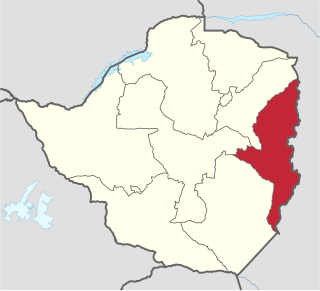
Manicaland is a province in eastern Zimbabwe. After Harare Province, it is the country's second-most populous province, with a population of 2.037 million, as of the 2022 census. After Harare and Bulawayo provinces, it is Zimbabwe's third-most densely populated province. Manicaland was one of five original provinces established in Southern Rhodesia in the early colonial period. The province endowed with country's major tourist attractions, the likes of Mutarazi Falls, Nyanga National Park and Zimbabwe's top three highest peaks. The province is divided into ten administrative subdivisions of seven rural districts and three towns/councils, including the provincial capital, Mutare. The name Manicaland is derived from one of the province's largest ethnic groups, the Manyika, who originate from the area north of the Manicaland province and as well as western Mozambique, who speak a distinct language called ChiManyika in Shona.

Masvingo, originally Victoria, is a province in southeastern Zimbabwe. It has a population of 1.485 million as of the 2012 census, ranking fifth out of Zimbabwe's ten provinces. Established by the British South Africa Company, it was one of the five original provinces of Southern Rhodesia. In 1982, two years after Zimbabwean independence, it was renamed Masvingo Province. The province is divided into seven districts, including Masvingo District, which contains the provincial capital Masvingo City.

Niassa[ˈnjasɐ] is a province of Mozambique. It has an area of 129,056 km2 and a population of 1,810,794 (2017). It is the most sparsely populated province in the country. Lichinga is the capital of the province. There are a minimum estimated 450,000 Yao people living in Mozambique. They largely occupy the eastern and northern part of the Niassa province and form about 40% of the population of Lichinga, the capital of this province.
Maputo Province[mɐˈputu] is a province of Mozambique; the province excludes the city of Maputo. The province has an area of 22,693 km2 (8,762 sq mi) and a population of 1,968,906. Its capital is the city of Matola.

Gaza is a province of Mozambique. It has an area of 75,709 km2 and a population of 1,422,460, which is the least populous of all the provinces of Mozambique.

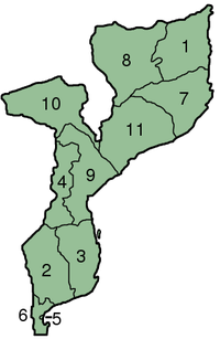
Mozambique is divided into 10 provinces (províncias) and 1 capital city (cidade) with provincial status:

The provinces of Peru are the second-level administrative subdivisions of the country. They are divided into districts. There are 196 provinces in Peru, grouped into 25 regions, except for Lima Province which does not belong to any region. This makes an average of seven provinces per region. The region with the fewest provinces is Callao (one) and the region with the most is Ancash (twenty).
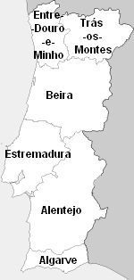
Beira was one of the six traditional provinces or comarcas of Portugal.

Eastern Province is one of Zambia's ten provinces. The province lies between the Luangwa River and borders with Malawi to the east and Mozambique to the south, from Isoka in the northeast to the north of Luangwa in the south. The provincial capital is Chipata. Eastern province has an area of 51,476 km2 (19,875 sq mi), locally shares border with three other provinces of the country and is divided into fifteen districts.

The provinces of Algeria are divided into 547 districts. The capital of a district is called a district seat. Each District is further divided into one or more municipalities (baladiyahs).
Administrative divisions of the Kingdom of Cambodia have several levels. Cambodia is divided into 24 provinces and the special administrative unit and capital of Phnom Penh. Though a different administrative unit, Phnom Penh is at provincial level, so de facto Cambodia has 25 provinces and municipalities.

The following outline is provided as an overview of and topical guide to Mozambique:
ISO 3166-2:MZ is the entry for Mozambique in ISO 3166-2, part of the ISO 3166 standard published by the International Organization for Standardization (ISO), which defines codes for the names of the principal subdivisions of all countries coded in ISO 3166-1.

Mutare District is a district in Manicaland Province of eastern Zimbabwe. The district headquarters is the city of Mutare.