
Aung San Suu Kyi is a Burmese politician, diplomat, author, and Nobel Peace Prize laureate (1991). She is the leader of the National League for Democracy and the first and incumbent State Counsellor, a position akin to a prime minister. She is also the first woman to serve as Minister for Foreign Affairs, for the President's Office, for Electric Power and Energy, and for Education. From 2012 to 2016 she was an MP for Kawhmu Township to the House of Representatives.

Myanmar is a unitary parliamentary republic under its constitution of 2008. The Economist Intelligence Unit has rated Myanmar as "hybrid regime" in 2016. The military of Burma holds a large amount of power in the government, despite the end of the last Burmese military dictatorship.

Yangon, formerly known as Rangoon, is the capital of the Yangon Region and commercial capital of Myanmar. Yangon served as the administrative capital of Myanmar until 2006, when the military government relocated the administrative functions to the purpose-built city of Naypyidaw [nèpjìdɔ̀] in central Myanmar. With over 7 million people, Yangon is Myanmar's largest city and its most important commercial centre.
The Burmese alphabet is an abugida used for writing Burmese. It is ultimately a Brahmic script adapted from either the Kadamba or Pallava alphabet of South India, and more immediately an adaptation of Old Mon or Pyu script. The Burmese alphabet is also used for the liturgical languages of Pali and Sanskrit.
The history of Myanmar covers the period from the time of first-known human settlements 13,000 years ago to the present day. The earliest inhabitants of recorded history were a Tibeto-Burman-speaking people who established the Pyu city-states ranged as far south as Pyay and adopted Theravada Buddhism.

Mandalay is the second-largest city and the last royal capital of Myanmar (Burma). Located 716 km (445 mi) north of Yangon on the east bank of the Irrawaddy River, the city has a population of 1,225,553.
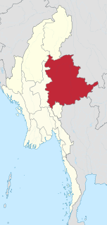
Shan State is a state of Myanmar. Shan State borders China to the north, Laos to the east, and Thailand to the south, and five administrative divisions of Burma in the west. Largest of the 14 administrative divisions by land area, Shan State covers 155,800 km², almost a quarter of the total area of Burma. The state gets its name from the Shan people, one of several ethnic groups that inhabit the area. Shan State is largely rural, with only three cities of significant size: Lashio, Kengtung, and the capital, Taunggyi. Taunggyi is 150.7 km north east of the nation's capital Naypyitaw.

Myanmar is divided into twenty-one administrative subdivisions, which include:

The Burma Campaign was a series of battles fought in the British colony of Burma, South-East Asian theatre of World War II, primarily involving the forces of the British Empire and China, with support from the United States, against the invading forces of Imperial Japan, Thailand, and the Indian National Army. British Empire forces peaked at around 1,000,000 land and air forces, and were drawn primarily from British India, with British Army forces, 100,000 East and West African colonial troops, and smaller numbers of land and air forces from several other Dominions and Colonies. The Burma Independence Army was trained by the Japanese and spearheaded the initial attacks against British Empire forces.

The Buddhist calendar is a set of lunisolar calendars primarily used in mainland Southeast Asian countries of Cambodia, Laos, Myanmar and Thailand as well as in Sri Lanka and Chinese populations of Malaysia and Singapore for religious or official occasions. While the calendars share a common lineage, they also have minor but important variations such as intercalation schedules, month names and numbering, use of cycles, etc. In Thailand, the name Buddhist Era is a year numbering system shared by the traditional Thai lunisolar calendar and by the Thai solar calendar.

The Myanmar national football team is the national team of Myanmar and is controlled by the Myanmar Football Federation. It was known as the Burma national football team until 1989, when Burma was renamed Myanmar. It finished second in the 1968 Asian Cup. They have participated in the Summer Olympics in 1972 and in the Asian Games. The Burma team was dominant in Asia in the 1960s and 1970s, having won the Asian Games twice; in 1966 and 1970, and the football event of the Southeast Asian Games on five successive occasions; in 1965, 1967, 1969, 1971 and 1973. Since then, Myanmar's highest achievement is the silver medal in 1993. Myanmar played its first World Cup qualifiers in 2007, losing 0–7 and 0–4 to China.

The Rohingya people are a stateless Indo-Aryan ethnic group who reside in Rakhine State, Myanmar. There were an estimated 1 million Rohingya living in Myanmar before the 2016–17 crisis. By December 2017, an estimated 625,000 refugees from Rakhine, Myanmar, had crossed the border into Bangladesh since August 2017. The majority are Muslim while a minority are Hindu. Described by the United Nations in 2013 as one of the most persecuted minorities in the world, the Rohingya population is denied citizenship under the 1982 Myanmar nationality law. According to Human Rights Watch, the 1982 laws "effectively deny to the Rohingya the possibility of acquiring a nationality". Despite being able to trace Rohingya history to the 8th century, Myanmar law does not recognize the ethnic minority as one of the eight "national indigenous races". They are also restricted from freedom of movement, state education and civil service jobs. The legal conditions faced by the Rohingya in Myanmar have been widely compared to apartheid by many international academics, analysts and political figures, including Nobel laureate Bishop Desmond Tutu, a South African anti-apartheid activist.

Naypyidaw, officially spelled Nay Pyi Taw, is the capital city of Myanmar and seat of the government of Myanmar. It is administered as the Naypyidaw Union Territory, as per the Constitution. It is unusual among Myanmar's cities, being an entirely planned city outside of any state or region, similar to Canberra in Australia, Brasília in Brazil, Washington, D.C. in the United States and Islamabad in Pakistan.
Buddhism in Myanmar is practiced by 90% of the country's population, and is predominantly of the Theravada tradition. It is the most religious Buddhist country in terms of the proportion of monks in the population and proportion of income spent on religion. Adherents are most likely found among the dominant Bamar people, Shan, Rakhine, Mon, Karen, Zo, and Chinese who are well integrated into Burmese society. Monks, collectively known as the sangha, are venerated members of Burmese society. Among many ethnic groups in Myanmar, including the Bamar and Shan, Theravada Buddhism is practised in conjunction with nat worship, which involves the placation of spirits who can intercede in worldly affairs.

Burmese pagodas are stupas that typically house Buddhist relics, including relics associated with Buddha. Pagodas feature prominently in Myanmar's landscape, earning the country the moniker "land of pagodas." Several cities in the country, including Mandalay and Bagan, are known for their abundance of pagodas. Pagodas are the site of seasonal pagoda festivals.

British rule in Burma, also known as British Burma, lasted from 1824 to 1948, from the Anglo-Burmese wars through the creation of Burma as a Province of British India to the establishment of an independently administered colony, and finally independence. Various portions of Burmese territories, including Arakan, Tenasserim were annexed by the British after their victory in the First Anglo-Burmese War; Lower Burma was annexed in 1852 after the Second Anglo-Burmese War. The annexed territories were designated the minor province, British Burma, of British India in 1862.

The internal conflict in Myanmar is a series of primarily ethnic conflicts within Myanmar that began shortly after the country, then known as Burma, became independent from the United Kingdom in 1948. The conflict has been labeled as the world's longest running civil war.

General elections were held in Myanmar on 8 November 2015, with the National League for Democracy winning a supermajority of seats in the combined national parliament. Voting occurred in all constituencies, excluding seats appointed by the military, to select Members of Assembly to seats in both the upper house and the lower house of the Assembly of the Union, and State and Region Hluttaws. Ethnic Affairs Ministers were also elected by their designated electorates on the same day, although only select ethnic minorities in particular states and regions were entitled to vote for them.


