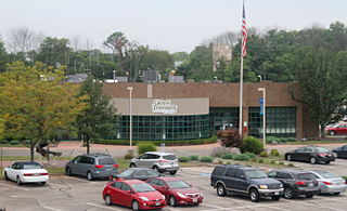
Green Township is one of the twelve townships of Hamilton County, Ohio, United States. The 2010 census found 58,370 people in the township. It was founded in 1809.

John Cleves Symmes was a delegate to the Continental Congress from New Jersey, and later a pioneer in the Northwest Territory. He was also the father-in-law of President William Henry Harrison.
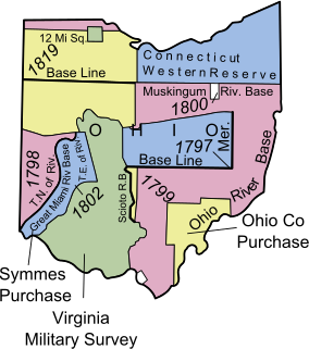
The Symmes Purchase, also known as the Miami Purchase, was an area of land totaling roughly 311,682 acres (487.003 sq mi) in what is now Hamilton, Butler, and Warren counties of southwestern Ohio, purchased by Judge John Cleves Symmes of New Jersey in 1788 from the Continental Congress.

Union Township is one of the eleven townships of Warren County, Ohio, United States, located in the central part of the county. It was established January 3, 1815 and named Union as it was formed from parts of Deerfield and Turtlecreek Townships. The 2000 census found 4,668 people in the township, up slightly from the 4,631 in 1990. Of those, 2,230 lived in the unincorporated part of the township and 2,438 lived in the village of South Lebanon.

Salem Township is one of the eleven townships of Warren County, Ohio, United States, located in the central part of the county. The 2000 census found 4,133 people in the township, up slightly from the 4,038 in 1990; of this total, 2,847 lived in the unincorporated portions of the township. It is the second smallest township in the county with 13,459 acres (54 km²). It is one of fourteen Salem Townships statewide.
Wayne Township is one of the eleven townships of Warren County, Ohio, United States. It is located in the northeast part of the county and includes the village of Waynesville, Ohio. Its population in 2000 was 7,250, up from 5,744 in 1990; 4,436 of this total lived in the unincorporated portions of the township. Waynesville is noted for its antique stores and is the home of a sauerkraut festival. Caesar Creek State Park is located here.

Hamilton Township, one of the eleven townships of Warren County, Ohio, United States, is in the south central portion of the county. The 2000 census found 9,630 people there, up significantly from the 5,900 in 1990. 8,645 of the total in 2000 lived in the unincorporated portions of the township. It is the fastest growing area of Warren County and is about 36 miles² (93 km²) in area.
The "College Township" was the full survey township located in the northwest corner of Butler County, Ohio, now corresponding to the civil township of Oxford, designated by the Ohio General Assembly to be the site of the state university now called Miami University. When Congress, on May 5, 1792, authorized the sale to John Cleves Symmes of the land known as the Symmes Purchase, one of the terms was that he would allocate a full township of land to support a university, a promise he never fulfilled. The United States Congress subsequently allowed the State of Ohio to pick a township in the public domain for a college. They chose a township in the first range in the Congress Lands, namely R1E T5.

Aid Township is one of the fourteen townships of Lawrence County, Ohio, United States. The township had a population of 907 at the 2000 census.
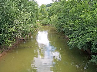
Symmes Creek is a 76.4-mile-long (123.0 km) tributary of the Ohio River in southern Ohio in the United States. Via the Ohio River, it is part of the watershed of the Mississippi River, draining an area of 357 square miles (920 km2) on the unglaciated portion of the Allegheny Plateau.
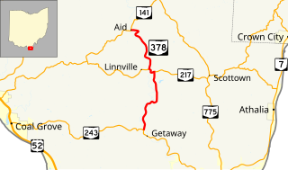
State Route 378 is a north–south state highway in the south-central portion of Ohio. SR 378's southern terminus is at SR 243 about 5 miles (8.0 km) south of the unincorporated community of Willow Wood. Its northern terminus is at SR 141 nearly 4 miles (6.4 km) northwest of Willow Wood.

Greenfield Township is one of the fifteen townships of Gallia County, Ohio, United States. As of the 2010 census the population was 495.
Sycamore Community School District is a school district in southwestern Ohio, United States, mainly in Hamilton County and the Greater Cincinnati area. It is commonly referred to as "Sycamore Community Schools". The district includes the communities of Blue Ash, Montgomery, Symmes Township, and some parts of Sycamore Township.

Willow Wood is an unincorporated community in western Windsor Township, Lawrence County, Ohio, United States, along Symmes Creek. Although it is unincorporated, it has a post office, with the ZIP code of 45696.
Waterloo is an unincorporated community in southeastern Symmes Township, Lawrence County, Ohio, United States, along Symmes Creek. Although it is unincorporated, it has a post office, with the ZIP code of 45688.
The Congress Lands West of Miami River was a land tract in southwest Ohio that was established by the Congress late in the 18th century. It is located south of the Greenville Treaty Line, east of Indiana, and north of the Great Miami River. The original survey in 1798 contained a triangular shaped slice of land, now located in Indiana, that extended to the Greenville line as it ran from Fort Recovery to opposite the mouth of the Kentucky River.

