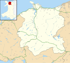
Snowdonia is a mountainous region in northwestern Wales and a national park of 823 square miles (2,130 km2) in area. It was the first to be designated of the three national parks in Wales, in 1951. It contains the highest peaks in the United Kingdom outside Scotland.
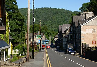
Betws-y-coed ; English: prayer house in the wood) is a village and community in the Conwy valley in Conwy County Borough, Wales, located in the historic county of Caernarfonshire, right on the boundary with Denbighshire, in the Gwydir Forest. It is now a very popular visitor destination in the Snowdonia National Park.

Llanrwst is a small market town and community on the A470 road and the River Conwy, in Conwy County Borough, Wales and in the historic county of Denbighshire. Llanrwst developed around the wool trade and became known also for the making of harps and clocks. Today, less than a mile from the edge of Snowdonia, its main industry is tourism. Notable buildings include almshouses, two 17th-century chapels, and the Parish Church of St Grwst, which holds a stone coffin of Llywelyn the Great. The 2011 census gave the town a population of 3,323.

Trefriw is a village and community in Conwy County Borough, Wales. It lies on the river Crafnant in North Wales, a few miles south of the site of the Roman fort of Canovium, sited at Caerhun. At the last three censuses the population of the community has been recorded as 842 in 1999, 915 in 2001, and 783 in 2011.

The River Conwy is a river in north Wales. From its source to its discharge in Conwy Bay it is 55 kilometres (34 mi) long and drains an area of 678 square km. "Conwy" was formerly Anglicised as "Conway."
The Conwy Valley line is a railway line in north-west Wales. It runs from Llandudno via Llandudno Junction to Blaenau Ffestiniog, and was originally part of the London and North Western Railway, being opened in stages to 1879. The primary purpose of the line was to carry slate from the Ffestiniog quarries to a specially built quay at Deganwy for export by sea. The line also provided goods facilities for the market town of Llanrwst, and via the extensive facilities at Betws-y-Coed on the London to Holyhead A5 turnpike road it served many isolated communities in Snowdonia and also the developing tourist industry. Although only a little over 27 miles (43 km) between Llandudno and Blaenau Ffestiniog, the journey takes over one hour, largely due to the sinuous and steeply graded nature of the route taken. Most of the stations along the line are treated as request stops.

Llanbedr-y-Cennin is a small village in Conwy county borough, Wales, in the community of Caerhun.
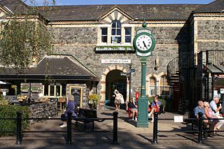
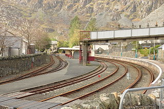
Betws-y-Coed railway station is a railway station on the Conwy Valley Line from Llandudno Junction to Blaenau Ffestiniog, Wales. It is situated 15+1⁄2 miles (24.9 km) south of Llandudno Junction.

Pont-y-Pant railway station is a single platform passenger station in the Lledr Valley, Wales, on the Conwy Valley line from Llandudno Junction to Blaenau Ffestiniog, which is operated by Transport for Wales Rail Limited. The station house is well maintained and used as a private dwelling.

Dolgarrog is a village and community in Conwy County Borough, in Wales, situated between Llanrwst and Conwy, very close to the Conwy River. The village is well known for its industrial history since the 18th century and the Eigiau dam disaster, which occurred in 1925. The population was 414 at the 2001 Census, increasing to 446 at the 2011 Census. The community extends up to, and includes part of, Llyn Cowlyd in the Carneddau.

Caerhun is a scattered rural community, and former civil parish, on the west bank of the River Conwy. It lies to the south of Henryd and the north of Dolgarrog, in Conwy County Borough, Wales, and includes several small villages and hamlets including Llanbedr-y-cennin, Rowen, Tal-y-bont and Ty'n-y-groes. It was formerly in the historic county of Caernarvonshire. At the 2001 census, it had a population of 1,200, increasing to 1,292 at the 2011 census. It includes a large part of the Carneddau range including the lakes of Llyn Eigiau, Llyn Dulyn and Llyn Melynllyn.
Ysgol Dyffryn Conwy is a bilingual co-educational comprehensive school in the town of Llanrwst in Conwy County Borough, North Wales. The school serves the community of Llanrwst and the many surrounding villages including the rural districts of Betws-y-Coed, Dolgarrog and Cerrigydrudion. There are around 658 pupils on roll, including 137 in the sixth form, which is lower than the figures at the time of the last inspection in 2014. Most of them are bilingual. The school has recently been moved onto one expanded site which had originally housed years 7-9 only. The site of the upper school has been developed into an NHS centre.
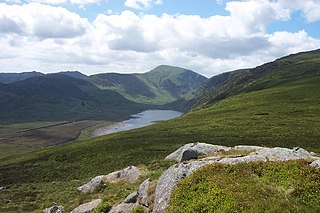
Llyn Eigiau is a lake on the edge of the Carneddau range of mountains in Snowdonia, Conwy, Wales. The name Eigiau is thought to refer to the shoals of fish which once lived here. Early maps refer to it as Llynyga. It is thought that a small number of Arctic char exist in the lake after they were transferred here from Llyn Peris, and certainly it is one of the few lakes in Wales to have its own natural brown trout. The lake is surrounded by mountains including Pen Llithrig y Wrach.

Rowen is a village on the western slopes of the Conwy valley in the parish of Caerhun and the former County of Caernarvonshire in Wales. It lies off the B5106 road, between Tal y Bont and The Groes Inn. Buildings of Gwynedd 2009 refers to the River Roe probably following the Roman route from Caerhun to Abergwyngregyn. Rowen has won tidiest village awards several times.
Tal-y-Cafn is a small settlement in Conwy county borough, north Wales, in the community of Eglwysbach.
John Williams was a Welsh cleric and schoolteacher.

Pen y Gaer is the location of a Bronze Age and Iron Age hillfort near the village of Llanbedr-y-Cennin in the Conwy valley, Wales.
Bro Garmon is a sparsely populated community in Conwy County Borough, in Wales. It is located on the eastern side of the Conwy Valley, stretching from north east of Llanrwst to just west of Pentrefoelas, and includes the villages of Capel Garmon, Glan Conwy, Melin-y-Coed, Nebo, Oaklands, Rhydlanfair and Pentre-tafarn-y-fedw. Moel Seisiog, on the eastern boundary, rises to a height of 1,535 feet (468 m). The main settlement, Capel Garmon, lies 2.4 miles (3.9 km) east of Betws-y-Coed, 5.2 miles (8.4 km) north west of Pentrefoelas, 4.4 miles (7.1 km) south of Llanrwst and 15.7 miles (25.3 km) south of Conwy. At the 2001 census the community had a population of 648, increasing slightly at the 2011 census to 652.