This article is written like a travel guide .(February 2023) |
Tamale | |
---|---|
Major city | |
Location of Tamale in Northern region, Dagbon | |
Coordinates: 09°24′27″N00°51′12″W / 9.40750°N 0.85333°W | |
Country | Ghana |
Region | Northern Region |
District | Tamale Metropolitan District |
Government | |
• Type | Mayor-Council |
• Mayor | Sule Salifu |
Area | |
• Total | 750 km2 (289.58 sq mi) |
Elevation | 151 m (495 ft) |
Population (2010) | |
• Total | 950,124 |
• Density | 480.77/km2 (1,245.18/sq mi) |
Time zone | UTC |
Postal codes | NT0000 - NT2701 |
Area code | 037 |
Website | tamalemetro.gov.gh |
Tamale ( Dagbani: [ˈtamali] ) is the capital city of the Northern Region of Ghana. [2] It is Ghana's third largest city, with a population of 950,000. [3] The city has been ranked as the fastest-growing city in West Africa. [2] [4] It is located 600 km (370 mi) north of Accra. [5]
Tamale is located in the Kingdom of Dagbon, Ghana's oldest Kingdom. Traditional authority are subservient to the King of Dagbon, the Ndan Yaa Naa, who is resident at Yendi (Yani). Yendi is the traditional capital and seat of Governance of the king. The language of the people in Tamale is Dagbani. [6]
Tamale boasts a thriving artistic and literary scene, evident in its numerous art studios, poets, and musicians. [7] Numerous art studios are scattered throughout the urban landscape. Local musicians frequently organize well-attended shows, filling stadiums with music and energy. [8] Notably, the Dagbanli language holds a special place in the city's poetic expression, with the "Lunsi" (historians and poets) playing a significant role in preserving and transmitting cultural heritage through their spoken word performances and compositions. [9]
Tamale sits at a strategic location due to its greater proximity European, West African, and North African markets compared to Ghana's southern cities . It serves as a political, economic and financial center of the Northern Ghana.The city connects the coastal and forest area of Ghana to West and North Africa. The city's central business district hosts regional branches of financial institutions and a considerable number of international and local non governmental organisations. [10]
The hospitality industry has grown significantly, with increasing investment in infrastracture. [11] [12] Tamale grew from a conglomeration of towns with an architectural blend of traditional mud houses and modern buildings. Tamale's new and modern facilities include the newly constructed Tamale Stadium (now Aliu Mahama sports Stadium named after late Ghana's vice-president, Alhaji Aliu Mahama), replacing the town's former principal football pitch, Kaladan Park. Improvements to Tamale's infrastructure occurred in the period leading up to the 2008 African Cup of Nations. [12] The Tamale sports stadium was renamed after the late Vice president, Alhaji Aliu Mahama in the year 2018. Motorcycles are a common form of transportation.
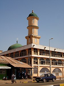
More than 80% of residents are Dagombas, and 90.5% are Muslims. [13] This is reflected by the multitude of mosques in Tamale, most notably the Tamale Central Mosque, Afa Ajura Mosque (Anbariya Mosque), Afa Basha mosque (Nuuria mosque) and The Ahmadiyyah Muslim mission Mosque. There are also many Churches in the city.
Tamale is located on the crossing of three ancient trade routes; it started to grow as a commercial centre for the Northern region centuries ago. The north–south road from Paga and Bolgatanga to Salaga had raiders passing, whilst other merchants brought their goods into Tamale. Salt came from Daboya, to the north-west of Tamale, and followed a road that continued to Yendi. A third road linked Gushegu to the capital and continued to the Gonja kingdom, Damongo. The present locations of the central market and the palace of the Gulkpe naa, [14] opposite Barclays Bank and near the library, mark the junctions of the ancient roads.
Around this palace, a residential neighbourhood began to grow. It is now known as Dagbangdabi-Fong (the name means "Traditional men area"). This was followed by Changli, Belipiela, and BuglanaFong ("Fetish Priest's area") further to the south. Each neighbourhood got its own local chief. As the distances to the market place grew, people started to settle elsewhere around the crossing, so the quarters of Tishigu and Abu-Abu came up. An influx of northerners from present-day Burkina Faso led to the building of Moshi Zongo. In the same time, the remote village of Vitteng came into existence.
Garden cities were brought to Tamale and at the back of Sakasaka grew Kalpohin Estates, even now a pleasant neighbourhood with plenty trees, big gardens, and small houses. In the 1970s, urban extensions such as Zogbeli, Lamakara, and Lamashegu were built, neighbourhoods characterised by checkboard planning of square house plots and orthogonal streets and alleys. Since 2000, Tamale seems to have grown more rapidly, so the whole district of Tamale is now urban agglomeration.
Tamale features a tropical wet and dry climate under the Köppen's climate classification. The metropolis experiences one rainy season from April to September or October, with a peak in September and August. The mean annual rainfall is 1100 mm within 95 days of rainfall in the form of tropical showers. Consequently, staple crop farming is highly restricted by the short rainy season. [15]
The dry season is usually from November to early April. It is influenced by the dry north-easterly (Harmattan) winds, while the rainy season is influenced by the moist south-westerly winds. The mean daytime temperatures range from 28 (December and mid-April) to 43 (March, early April) degrees Celsius, while mean nighttime temperatures range from 18 (December) to 25 (February, March) degrees Celsius. The mean annual daily sunshine is about 7.5 hours.
Climate data for Tamale | |||||||||||||
---|---|---|---|---|---|---|---|---|---|---|---|---|---|
Month | Jan | Feb | Mar | Apr | May | Jun | Jul | Aug | Sep | Oct | Nov | Dec | Year |
Record high °C (°F) | 40.0 (104.0) | 41.5 (106.7) | 42.7 (108.9) | 42.8 (109.0) | 40.2 (104.4) | 37.8 (100.0) | 35.6 (96.1) | 35.4 (95.7) | 34.8 (94.6) | 38.2 (100.8) | 39.2 (102.6) | 38.6 (101.5) | 42.8 (109.0) |
Mean daily maximum °C (°F) | 35.4 (95.7) | 36.9 (98.4) | 37.1 (98.8) | 35.4 (95.7) | 33.6 (92.5) | 31.1 (88.0) | 29.8 (85.6) | 29.2 (84.6) | 29.9 (85.8) | 32.2 (90.0) | 34.8 (94.6) | 34.9 (94.8) | 33.4 (92.1) |
Daily mean °C (°F) | 27.9 (82.2) | 30.1 (86.2) | 30.9 (87.6) | 29.8 (85.6) | 28.6 (83.5) | 26.8 (80.2) | 26.0 (78.8) | 25.8 (78.4) | 25.9 (78.6) | 27.3 (81.1) | 28.2 (82.8) | 27.5 (81.5) | 27.9 (82.2) |
Mean daily minimum °C (°F) | 20.4 (68.7) | 22.8 (73.0) | 24.6 (76.3) | 24.6 (76.3) | 23.6 (74.5) | 22.5 (72.5) | 22.1 (71.8) | 21.9 (71.4) | 21.8 (71.2) | 21.9 (71.4) | 21.6 (70.9) | 20.3 (68.5) | 22.3 (72.1) |
Record low °C (°F) | 15.0 (59.0) | 16.1 (61.0) | 18.9 (66.0) | 19.4 (66.9) | 18.9 (66.0) | 18.9 (66.0) | 18.3 (64.9) | 18.9 (66.0) | 18.9 (66.0) | 18.9 (66.0) | 16.1 (61.0) | 13.9 (57.0) | 13.9 (57.0) |
Average precipitation mm (inches) | 4 (0.2) | 12 (0.5) | 48 (1.9) | 88 (3.5) | 112 (4.4) | 146 (5.7) | 142 (5.6) | 198 (7.8) | 231 (9.1) | 92 (3.6) | 14 (0.6) | 3 (0.1) | 1,090 (42.9) |
Average precipitation days (≥ 0.3 mm) | 1 | 1 | 4 | 7 | 10 | 12 | 13 | 15 | 19 | 12 | 2 | 1 | 97 |
Average relative humidity (%) | 27 | 32 | 45 | 61 | 70 | 77 | 80 | 79 | 80 | 74 | 59 | 40 | 60 |
Mean monthly sunshine hours | 266.6 | 237.3 | 251.1 | 231.0 | 248.0 | 204.0 | 161.2 | 139.5 | 156.0 | 260.4 | 282.0 | 272.8 | 2,709.9 |
Mean daily sunshine hours | 8.6 | 8.4 | 8.1 | 7.7 | 8.0 | 6.8 | 5.2 | 4.5 | 5.2 | 8.4 | 9.4 | 8.8 | 7.4 |
Source: Deutscher Wetterdienst [16] |
Tamale has a mayor–council government system in which the mayor is vested with extensive executive powers. The mayor is appointed by the Ghana president and approved by the town council, the Tamale Metropolitan Assembly, although suggestions have been made by the residents of Tamale to increase accountability of the office by having the mayor elected. The current mayor of Tamale is Hon. Sule Salifu. [17] The name Tamale Metropolitan Assembly serves both for the local parliament and for the local executive. Local policies are always executed in this name, so for example, illegal constructions often show the command "remove by TMA" (meaning that the Tamale Metropolitan Assembly or its executive has ordered to remove the building as it is contrary to current urban land-use planning). As the local executive, Tamale Metropolitan Assembly is the strong arm of the mayor, his or her civil service. If mention is made of assembly women or men, however, the reference is to the elected representatives of the inhabitants of Tamale. They form the assembly properly speaking, and must decide about local by-laws before they can come into force. The name "Tamale Metropolitan District" is used in the geographical sense, to refer to the area within its borders.
Tamale is the principal centre of education in Northern Ghana. Currently, a total of 742 basic schools are within the metropolis. This comprises 94 kindergartens, 304 primary, 112 junior high, and 14 senior high schools. The rest are technical/vocational institutions, two colleges of education, a technical university and two other universities – one public and the other private. [11]
In the Education Ridge neighbourhood in the north-western part of the town and covering an area around 3 km2, 20 schools ranging from kindergartens through junior high and senior high schools, teachers' training colleges, the Tamale Technical University, and a university are located. The numerous trees lining the streets in this part of the town give it a tropical rainforest outlook. The University for Development Studies (UDS) has two campuses located in Tamale and one in nearby Nyankpala. The headquarters of the UDS is also located in Tamale. [18]
Tamale is served by Tamale Internationa Airport. Located about 11 km (6 nmi; 7 mi) from downtown Tamale, the airport is mainly used by commercial airlines such as Africa World Airlines and Passion Air which are the only operational companies currently. They run regular flights between Tamale and Accra's Kotoka International Airport, along with other regional capitals. [19]
There are Public Transports from Tamale to major citie such as Kumasi; Accra, Mim, Ahafo ; Cape Coast, Sunyani; Takoradi; Tema; Ho; Wa; Bolgatanga; Elubo; Aflao, Techiman; Public transportation in the form of taxis used to be the most convenient means of getting around Tamale for visitors to the town until the arrival of the Tri-cycles, popularly called "Mahama-Cambuu" or yellow-yellow. Mahama Cambuu is a coined name by the local people from the expression "Mahama can do". This is because these Tri-cycles (mostly yellow in color) came in the era of the former president, H.E John Dramani Mahama. It is comparatively cheaper than the Taxis and usually on the move unlike the Taxis that are regularized and stationed at a points. It is however, not very safe compared to the Taxis. The popular means of travel for the locals, however, is by motorbike. This phenomenon is helped by the existence of bike paths in the town, making it one of the most bike-friendly settlements in the Northern region. Transportation out of town is facilitated by the Tamale's bus rapid transit system, tro-tro private mini-bus system, MetroMass Bus-Based Mass Transit system, and STC Bus Lines, along with a host of charter bus companies, all of which provide transport to connect Tamale with the many other surrounding towns and cities.
Tamale has sister city relations with:
City | Country | Date | Reference |
---|---|---|---|
Louisville, Kentucky | United States | 1979 | [20] |
Fada N'gourma | Burkina Faso | 2003 | [21] |
Commune II Niamey | Niger | 2007 | [22] |
1. Picona Hotel
2. Radarch Lodge and Conference Centre
3. Miricha Hotel
4. Nim Avenue Hotel
5. Modern City Hotel
6. Sabonkudi estates
7. Regal hotel
8. Target Hills hotel
9. Pioneer lodge
10. B Sheini hotel
11. Naat guesthouse
12. Ganaa hotel
13. Global dream hotel
14. Aisha Homes
The Dagombas or Dagbamba are an ethnic group of Ghana, and Togo. They number more than 3.1 million people. The term Dagbamba is originally extended to refer to other related peoples who were unified by Naa Gbewaa including the Mamprusi and Nanumba. The Dagomba country is called Dagbon and they speak Dagbanli language. Dagbanli is the most spoken language of northern Ghana and second most widely spoken local language of Ghana. Dagbanli belongs to the Mabia (Mole-Dagbani) subgroup of the Gur languages, a large group of related languages in West Africa. The Dagomba practises both patrilineal and matrilineal systems of inheritance.
Yendi , is the traditional capital of the Kingdom of Dagbon and the administrative centre of the Yendi Municipal District in the Northern Region of Ghana. As of 2021, the population of Yendi was 154,421 comprising 76,142 males and 78,279 females. It is the seat of the King of the Dagbon, Ghana's oldest kingdom.
The Northern Region is one of the sixteen regions of Ghana. It is located in the north of the country, and it is the second largest of the sixteen regions. Until its split, it covered an area of 25,000 square kilometres, or 10 percent of Ghana's area. In December 2018, the Savannah Region and North East Region were created from it. The Northern Region is divided into 16 districts. The region's capital is Tamale, Ghana's third largest city.
Alhaji Aliu Mahama was a Ghanaian engineer and politician who was Vice-President of Ghana from 7 January 2001 to 7 January 2009. A member of the New Patriotic Party, he was Ghana's first Muslim Vice-President.
Ghana gained independence from the British on 6 March 1957. It is a member of the Commonwealth of Nations. The country became a republic on July 1, 1960.
Savelugu is a town and the capital of Savelugu Municipal, a municipality in the Northern Region of north Ghana. Savelugu has a 2012 settlement population of 38,074 people. There are many villages under Savelugu kingship. Most of the villages are smaller.
The Damba festival is the largest festival in Ghana, celebrated by the peoples of the Northern, Savanna, North East, Upper East and Upper West Regions of Ghana. In recent times, Damba has become a multinational festival, attracting visitors from all over the world. The festival is annually celebrated in Germany, USA, and UK.
Nyankpala, with the appelation Beyom Yili, is a town located about 10 miles south-west of Tamale, the capital of the Northern Region of Ghana. The University for Development Studies (UDS) has its premier campus located in the town. This campus is the first of the university's campuses, the first to be established in northern Ghana.
The Mole-Dagbon, also called Mossi-Dagbon or Mole-Dagbani are a meta-ethnicity and western Oti-Volta Gur ethno-linguistic group residing in six present-day West Africa countries namely: Benin, Burkina Faso, Ghana, Ivory Coast, Mali and Togo. They number more than 15 million. The Mole/Mossi/Moore people are located primarily in Burkina Faso while Dagbon is in Ghana.
Kalpohin is a community in Tamale Metropolitan District in the Northern Region of Ghana.
Mujahid Ahmed Bello known by his stage name Fancy Gadam, is a Ghanaian afropop, dancehall and reggae musician. In 2017 he won Ghana Music Awards for Best New Artist and in 2020 was named BestAfrobeat Entertainer at the International Reggae and World Music Awards.
Yendi Senior High School(YESS) is a coeducational secondary school in Yendi in the Northern Region of Ghana. The school was established in 1970, first as a middle-boarding school to enable access to basic education for communities in the Eastern Corridor enclave, before being upgraded in September of the same year to the status of a secondary school. For the first academic year, the school had only a total student population of 77, with 70 boys and seven girls. The first headmaster of the school was Cletus Bernard Teviu. He headed the school for nearly a decade, spanning between 1970 and 1979, and one of the hostels in the school has been named in his honour. In the year 2020 when the school celebrated its 50th anniversary, the total student population was 2,724 and the number of teachers was 121. The school operates as a boarding school, but few students attend as day students.
Abibata Shanni Mahama Zakariah was born in Yendi and is the daughter of Alhaji Shanni Mahama, who was a former MP for Yendi Constituency and a Deputy Minister for Agriculture in the government of former prime minister K. A. Busia. She was appointed Deputy CEO of the Microfinance and Small Loans Centre (MASLOC) in 2017 and got elevated to the position of substantive Chief Executive in September 2021 after her immediate boss, Stephen Amoah, left to start a career as Parliamentarian for the Nhyiaso Constituency.
Ghana Senior High School (Ghanasco) is a co-educational second cycle institution located in Tamale, Northern Region of Ghana.
Umar Farouk Aliu Mahama is a Ghanaian politician who is a member of the New Patriotic Party (NPP). He is the member of parliament for the Yendi Constituency after winning in the 2020 parliamentary elections.
Ibrahim Mahama is a Ghanaian lawyer, and civil servant. He was Ghana's Commissioner for Secretariats and Departments from 1967 to 1968 and Commissioner for Information from 1968 to 1969.
Shanni Hazrat Mahama is a Ghanaian politician and member of the first parliament of the second republic of Ghana representing Yendi constituency in the Northern Region of Ghana under the membership of the Progress Party (PP).
Tamale Senior High School formerly Government Secondary School, Tamale, Gbewaa Secondary School, and more recently Tamale Secondary School is a co-educational second cycle boarding school located at Education Ridge, a suburb of the Sagnarigu Municipality. The school was founded in 1951 by the then British Colonial Authorities as the first second cycle institution of the Northern Territories.
Ramatu Mahama was a Ghanaian educationist who served as the second lady of Ghana from 2001 to 2009. Mahama was the wife of the 4th vice-president of Ghana, the late Aliu Mahama.