
Playa del Rey is an affluent beachside community in the Westside of the city of Los Angeles, California. It has a ZIP code of 90293 and area codes of 310 and 424. As of 2014, the Playa del Rey population was 12,129 people. Since 2000, it has had a population growth of 14.61 percent.
Huatulco, formally Bahías de Huatulco, centered on the town of La Crucecita, is a tourist development in Mexico. It is located on the Pacific coast in the state of Oaxaca. Huatulco's tourism industry is centered on its nine bays, thus the name Bahias de Huatulco, but has since been unofficially shortened to simply Huatulco. Huatulco has a wide variety of accommodations from rooms for rent, small economy luxury hotels, luxury villas, vacation condominiums, bed and breakfasts, as well as several luxury resorts standing on or near the shores of Tangolunda Bay. The Camino Real Zaashila, Quinta Real Huatulco, Las Brisas, Dreams Resort & Spa, and the Barceló are examples of the most popular larger resorts in the area.

San Bartolomé de Tirajana is a village and a Spanish municipality in the south-eastern part of the island of Gran Canaria in the Las Palmas province in the Canary Islands. With an area of 333.13 km2 (128.62 sq mi), San Bartolomé de Tirajana is the largest municipality in area on the island as well as the Canary Islands. The population is 56,698 (2013).

Federal Highway 1 is a free (libre) part of the federal highway corridors of Mexico, and the highway follows the length of the Baja California Peninsula from Tijuana, Baja California, in the north to Cabo San Lucas, Baja California Sur, in the south. The road connects with Via Rapida, which merges into the American Interstate 5 (I-5) at the international border south of San Ysidro, California.

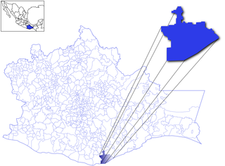
La Paz is a municipality of the Mexican state of Baja California Sur. Its area of 20,275 km² makes it the municipality in Mexico with the fourth-largest area. It had a population of 290,286 inhabitants in the 2015 census. Its municipal seat, also named La Paz, is the state capital.
The Imperial Highway is a west-east thoroughfare in the counties of Los Angeles, Orange, San Diego, and Imperial in California. The main portion of the existing route begins at Vista Del Mar in Los Angeles near the Los Angeles International Airport and ends at the Anaheim - Orange line at Via Escola where it becomes Cannon Street. Formerly, the Route used to extend from Vista Del Mar to Calexico, where a portion of the highway still exists, but the Route was replaced with other highways, rendering the older portions of the Imperial Highway to fall out of use.
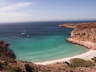
Isla Partida is separated from Isla Espíritu Santo by a shallow, narrow channel. These two islands, in the Gulf of California, are protected by UNESCO as biospheres. They are located a short boat ride from La Paz, which lies on the Baja California Peninsula in Mexico. It has a land area of 15.495 km (9.628 mi) and is part of the Municipality of La Paz in Baja California Sur.
The El Salvador national beach soccer team represents El Salvador in international beach soccer competitions and is controlled by the FESFUT, the governing body for football in El Salvador.
La Playa is a bayfront neighborhood in the Point Loma community of San Diego, California. It is bordered by the San Diego Bay on the east, Naval Base Point Loma on the south, the Wooded Area neighborhood to the west and Point Loma Village/Roseville-Fleetridge to the north. It lies across a channel from Shelter Island.
Bahía Concepción is a bay on the Gulf of California, in southeastern Mulegé Municipality and the central-eastern part of the Baja California Peninsula, in Baja California Sur state, Mexico.

General Villamil, also known as Playas, is a Guayas canton in Ecuador. The Playas canton is located at the south western area of the Guayas Province. Its Canton Capital is General José de Villamil, also known as Playas. It is located 96 kilómeters from the capital of the Guayas Province, Guayaquil. It borders to the north and east with Guayaquil Canton, on the west with Santa Elena Province, and to south with the Pacific Ocean. Its territory has an area of 280 square kilometres and has a population of 31,000 citizens, with 25,000 of them living in the canton's capital.
The 2015 CONCACAF Beach Soccer Championship was a beach soccer tournament which took place in Costa del Sol, El Salvador on 28 March – 4 April 2015. This was the first time the CONCACAF Beach Soccer Championship was held in Central America. All matches were played at Estadio de Fútbol Playa in La Paz Department, with an official capacity of 2,000.
The Glass Pilsener of Football Beach 2016 will be the fourth edition of the tournament sponsored by Beach Soccer Worldwide (BSWW) that will develop of the 24 to 26 March in La Paz, El Salvador. The teams participants are the seleccion national of El Salvador, the selections of United States, Portugal and Argentina.

The Complejo Recreativo y Cultural La Guancha is a recreational complex in barrio Playa in Ponce, Puerto Rico with family recreational and cultural facilities that opened on June 23, 1998. The highlight of the complex is the Paseo Tablado La Guancha, which is flanked by a beach, an observation tower, an amphitheater, and 24 open-air kiosks. It was developed during the administration of Mayor Rafael Cordero Santiago.
Harumi Fujita is a Japanese researcher of Mexican archaeology, who has specialized in pre-classical period of the northern states of Baja California and Baja California Sur. Her research has shown that fishing cultures had arisen in the area at the end of the Pleistocene period, indicating an occupation from at least 11,000 years ago. In a cave shelf known as the Babisuri Shelter, radiocarbon dating indicated the area may have been occupied 40,000 years ago.


