Temple, Texas

Last updated

Temple, Texas
Downtown-temple-630x476.jpg
Downtown Temple
Motto: 
Make Temple Great!
Bell Temple.svg
Location of Temple, Texas
Relief map of Texas.png
Red pog.svg
Temple, Texas
Location in Texas, United States & North America
Usa edcp relief location map.png
Red pog.svg
Temple, Texas
Temple, Texas (the United States)
North America laea relief location map with borders.jpg
Red pog.svg
Temple, Texas
Temple, Texas (North America)
Coordinates: 31°06′N97°21′W / 31.100°N 97.350°W / 31.100; -97.350
Country United States
State Texas
Counties Bell
SettledJune 29, 1881
Incorporated1882
Founded byBernard Moore Temple
Named for Bernard Moore Temple
Government
  Type Council–manager
   City Manager Brynn Myers
Area
[1]
  Total76.01 sq mi (196.85 km2)
  Land71.17 sq mi (184.33 km2)
  Water4.84 sq mi (12.52 km2)
Elevation
719 ft (219 m)
Population
 (2020)
  Total85,416
  Density1,102.14/sq mi (425.53/km2)
Time zone UTC−6 (Central (CST))
  Summer (DST) UTC−5 (CDT)
ZIP Codes
76501–76505, 76508
Area codes Area code 254
FIPS code 48-72176 [2]
GNIS feature ID1369696 [3]
Website www.templetx.gov

Temple is a city in Bell County, Texas, United States. As of 2020, the city has a population of 82,073 according to the U.S. census, and is one of the two principal cities in Bell County. [4]

Contents

Located near the county seat of Belton, Temple lies in the region referred to as Central Texas and is a principal city in the Killeen–Temple–Fort Hood metropolitan area, which as of the 2020 Census had a population of 475,367. [5] Located off Interstate 35, Temple is 65 miles north of Austin, 34 miles south of Waco and 27 miles east of Killeen.

The primary economic drivers are the extensive medical community (mostly due to Baylor Scott & White Medical Center – Temple) and goods distribution based on its central location between the Dallas-Fort Worth, San Antonio, and Houston metropolitan areas, and proximity to larger neighbors Austin and Waco.[ citation needed ]

History

Temple was founded as a railroad town in 1881 by the Gulf, Colorado and Santa Fe Railroad. It was incorporated in 1882. [6] The town was named after a Santa Fe Railroad official, Bernard Moore Temple. [7] Mr. Temple was a civil engineer and former surveyor with the Gulf, Colorado and Santa Fe Railway Company.

In 1882, the Missouri–Kansas–Texas Railroad built through the town, and soon after, the Santa Fe railroad made Temple a division point. In its early years, Temple was a town of shacks and tents with a large number of saloons and tough characters found in the early West. Locally, it was nicknamed "Tanglefoot,” because some residents found that the combination of muddy streets and liquor made walking through the town challenging.

Very shortly after the town was incorporated in 1882, two private schools were founded in the city: the Temple Academy was organized and a public school was established in 1884. In 1893, the annual Temple Stag Party began, growing out of a private Thanksgiving celebration attended by some of the town's leading men. It was held until 1923. [8]

The Temple Railroad and Heritage Museum, on the second floor of the Santa Fe Railroad station at 315 West Avenue B, commemorates the significance of railroads for the city. [9]

Geography

Temple is located northeast of the center of Bell County at 31°6′30″N97°23′21″W / 31.10833°N 97.38917°W / 31.10833; -97.38917 (31.108381, −97.389125). It is the second-largest city in Bell County. [10] It is bordered to the southwest, on the opposite side of the Leon River, by Belton, the county seat.

Temple is situated within a relatively short drive of most of the major cities of Texas: 124 mi north to Fort Worth, 130 mi north-northeast to Dallas, [11] 65 mi southwest to Austin, 147 mi southwest to San Antonio, and 168 mi southeast to Houston. The city is located right on Interstate 35, running alongside the Balcones Fault with very varied geography. Towards the east lies the Blackland Prairie region (a rich farming area), and towards the west, the terrain rises with low, rolling, limestone-layered hills at the northeastern tip of the Texas Hill Country.

According to the United States Census Bureau, the city has a total area of 74.9 square miles (194 km2), of which 70.1 square miles (182 km2) are land and 4.8 square miles (12 km2) are covered by water. [12]

Climate

Climate data for Temple, Texas
MonthJanFebMarAprMayJunJulAugSepOctNovDecYear
Mean daily maximum °F (°C)57
(14)
62
(17)
70
(21)
77
(25)
84
(29)
90
(32)
95
(35)
95
(35)
89
(32)
80
(27)
68
(20)
59
(15)
77
(25)
Mean daily minimum °F (°C)35
(2)
39
(4)
46
(8)
54
(12)
63
(17)
70
(21)
72
(22)
72
(22)
66
(19)
56
(13)
45
(7)
38
(3)
55
(13)
Average precipitation inches (mm)2.13
(54)
2.69
(68)
3.19
(81)
2.59
(66)
4.51
(115)
4.23
(107)
1.93
(49)
2.25
(57)
3.70
(94)
3.97
(101)
2.94
(75)
2.75
(70)
36.88
(937)
Source: weather.com [13]

Demographics

Historical population
CensusPop.Note
1890 4,047
1900 7,06574.6%
1910 10,99355.6%
1920 11,0330.4%
1930 15,34539.1%
1940 15,3440.0%
1950 25,46766.0%
1960 30,41919.4%
1970 33,4319.9%
1980 42,48327.1%
1990 46,1098.5%
2000 54,51418.2%
2010 66,10221.3%
2020 82,07324.2%
2022 (est.)89,458 [14] 9.0%
U.S. Decennial Census
Temple racial composition as of 2020 [15]
(NH = Non-Hispanic) [lower-alpha 1]
RaceNumberPercentage
White (NH)41,97651.14%
Black or African American (NH)12,03114.66%
Native American or Alaska Native (NH)2810.34%
Asian (NH)2,0902.55%
Pacific Islander (NH)1580.19%
Some Other Race (NH)3540.43%
Mixed/Multi-Racial (NH)3,6604.46%
Hispanic or Latino 21,52326.22%
Total82,073

As of the 2020 United States census, there were 82,073 people, 28,276 households, and 18,036 families residing in the city.

As of the 2010 census, [2] 66,102 people, 23,359 households, and 15,878 families resided in the city. The population density was 834.2 inhabitants per square mile (322.1/km2). The 28,005 housing units averaged 359.8 per square mile (138.9/km2). The racial makeup of the city was 68.1% White, 23.7% Hispanic or Latino, 16.9% African American, 2.1% Asian, 0.6% Native American, 0.1% Pacific Islander, and 3.3% from two or more races.

Of the 23,359 households, 32.1% had children under the age of 18 living with them, 49.6% were married couples living together, 14.0% had a female householder with no husband present, and 32.0% were not families. About 28.4% of all households were made up of individuals, and 10.7% had someone living alone who was 65 years of age or older. The average household size was 2.44 and the average family size was 3.29.

In the city, the population was distributed as 24.1% under the age of 18, 9.2% from 18 to 24, 28.6% from 25 to 44, 20.0% from 45 to 64, and 15.8% who were 65 years of age or older. The median age was 35 years. For every 100 females, there were 91.7 males. For every 100 females age 18 and over, there were 87.2 males.

The median income for a household in the city was $47,240 and for a family was $42,795. Males had a median income of $30,858 versus $22,113 for females. The per capita income for the city was $25,740. About 10.8% of families and 12.5% of the population were below the poverty line, including 20.0% of those under age 18 and 9.8% of those age 65 or over. Temple's homeless population is approximately 1.9%. Assistance to the homeless is provided by Feed My Sheep and the Salvation Army. [18]

Economy

Over 100 years ago, the local economy began with the regional Santa Fe Railroad hospital. Temple now thrives in a complex economy, with both goods distribution and its reputation as a regional medical center leading the way. Baylor Scott & White Health is the largest employer in the area with about 12,000 employees, most located at Baylor Scott & White Medical Center – Temple.

Temple is home to many regional distribution centers and is headquarters to two large, multinational companies, Wilsonart International and McLane Company, [19] as well as parent McLane Group. In addition to some manufacturing, also a developing customer service/ call center industry exists. Temple is also home to the Temple Bottling Company, which produces Dr Pepper (with Imperial Cane sugar).

Temple is within 30 miles (48 km) of Fort Hood, and military personnel contribute a portion of the city's economy.

Education

Primary and secondary schools

Temple is largely served by the Temple Independent School District. The district has one high school, three middle schools, nine elementary schools, and three supplemental learning programs (early childhood center, alternative learning center, and an innovative academy high school program). Students within the local school district attend highly regarded Temple High School. [20] In addition to award-winning academic/honors programs in arts and sciences and the International Baccalaureate (IB) curriculum, the high-school has a thriving athletic program. In addition, small portions of the city are served by Belton ISD, Troy ISD, and Academy ISD. [21]

Several private schools serve Temple, including Christ Church School, Saint Mary's Catholic School (Pre-K–8), [22] Providence Preparatory School (PreK-12), the associated Holy Trinity Catholic High School, [23] and Central Texas Christian School (K–12). [24]

Colleges and universities

Temple College offers two-year associate degrees in a variety of subjects, with strong programs in business administration, information technology, and nursing. Temple College was the first college located in Temple, and opened in 1926. [25]

Temple is also home to one of the Texas A&M College of Medicine campuses. It operates in conjunction with the Baylor Scott & White Medical Center – Temple and the Olin Teague Veterans' Hospital Center.

Media

The main city newspaper is the Temple Daily Telegram . Radio stations licensed in Temple include FM stations KVLT-FM, KBDE-FM, KLTD-FM, and KRYH-LP; [26] and AM stations News Radio 1400, [27] and a number of other nearby radio stations can be heard in Temple. [28] A number of broadcast television channels are available in the city: KCEN-TV (NBC), KWTX-TV (CBS), KXXV-TV (ABC), KWKT-TV (Fox), The CW and Telemundo, plus several alternate broadcast channels including MeTV, Cozi, iON, MyNetworkTV, grit and local weather. [29] For cable and satellite television service, Temple is served by Charter Spectrum (formerly Time Warner Cable), DirecTV, Dish Network, and Grande Communications. [30]

Infrastructure

Transportation

The Hill Country Transit District (The HOP) operates three bus routes within the city, with an additional bus connection to Killeen.

Temple was founded as a railroad junction and serves as a major freight railroad hub to this day. Both the Union Pacific Railroad and BNSF Railway have mainlines serving the city, and a BNSF rail yard and locomotive maintenance facility are located here. Amtrak serves the city with its Texas Eagle passenger train, which stops at the Temple Railway Station.

Temple has general aviation services via Draughon-Miller Central Texas Regional Airport. While commercial airline service is not currently available in the city, Temple is served by these nearby airports:

High-speed rail

In 2009, the Texas Department of Transportation (TxDOT) proposed the Texas T-Bone High Speed Rail Corridor that would create a high-speed rail line from Dallas-Fort Worth to San Antonio and another line from Houston that would connect with the first line. [31] While the location for the connection of the two lines had not been officially established, the mayor at the time, Bill Jones III, made an effort to ensure that connection happened in Temple. [32] Temple would be a stop along the line, regardless of where that connection between the two lines would be. The next year in 2010, TxDOT received a federal grant to conduct a study for a line connecting Oklahoma City with San Antonio, and Temple was in the pathway of that line. [33] In 2013, a consultant for the Texas High Speed Rail Corporation stated that the only two connections being considered for the two lines were a connection in Temple and a connection in San Antonio; they expected to make that decision by the end of 2014. The organization also indicated that they plan to have the high-speed rail in operation by 2025. [34] If that connection occurred in Temple, the Killeen – Temple – Fort Hood metropolitan area, with a population of 420,375, would be within about 45 minutes of Dallas, Fort Worth, Houston, and San Antonio.

Health care

Baylor Scott & White Medical Center - Temple Scott-white-hospital-temple.jpg
Baylor Scott & White Medical Center – Temple

Temple is known as a regional medical center, with four major hospitals: Baylor Scott & White Medical Center, Baylor Scott & White McLane Children's Medical Center, Olin E. Teague Veterans' Medical Center, and McLane Children's Specialty Clinic. Baylor Scott & White Health is the largest employer in town with over 11,000 employees.

Texas State Soil and Water Conservation Board

The Texas State Soil and Water Conservation Board has its headquarters in Temple. [35]

Law enforcement

Temple is policed by the Temple Police Department and the Bell County Sheriff's Office. The Texas Department of Criminal Justice operates a regional office in the city. [36] The Texas Highway Patrol maintains an office on I-35 in Temple. [37]

Postal service

The United States Postal Service operates a regional office in the city. [38]

Notable people

See also

Explanatory notes

  1. Note: the US Census treats Hispanic/Latino as an ethnic category. This table excludes Latinos from the racial categories and assigns them to a separate category. Hispanics/Latinos can be of any race. [16] [17]

Related Research Articles

<span class="mw-page-title-main">Paris, Texas</span> City in the United States

Paris is a city and county seat of Lamar County, Texas, United States. Located in Northeast Texas at the western edge of the Piney Woods, the population of the city was 24,171 in 2020.

<span class="mw-page-title-main">Bell County, Texas</span> County in Texas, United States

Bell County is a county in the U.S. state of Texas. It is in Central Texas and its county seat is Belton.

<span class="mw-page-title-main">Chillicothe, Illinois</span> City in Illinois, United States

Chillicothe is a city on the Illinois River in Peoria County, Illinois, United States. The population was 6,097 at the 2010 census. Chillicothe is just north of the city of Peoria and is part of the Peoria Metropolitan Statistical Area.

<span class="mw-page-title-main">Clovis, New Mexico</span> City in the United States

Clovis is a city in and the county seat of Curry County, New Mexico. The city had a population of 37,775 as of the 2010 census, and a 2020 census population of 38,567. Clovis is located in the New Mexico portion of the Llano Estacado, in the eastern part of the state.

<span class="mw-page-title-main">Ardmore, Oklahoma</span> City in Oklahoma, United States

Ardmore is the county seat of Carter County, Oklahoma, United States. The population was 24,725 at the time of the 2020 census, a 1.8% increase over the 2010 census figure of 24,283. The Ardmore micropolitan statistical area had an estimated population of 48,491 in 2013. Ardmore is 90 miles (140 km) from both Oklahoma City and Dallas/Fort Worth, Texas, at the junction of Interstate 35 and U.S. Highway 70, and is generally considered the hub of the 13-county region of South Central Oklahoma, also known by state tourism pamphlets as "Chickasaw Country" and previously "Lake and Trail Country". It is also a part of the Texoma region. Ardmore is situated about 9 miles (14 km) south of the Arbuckle Mountains and is located at the eastern margin of the Healdton Basin, one of the most oil-rich regions of the United States.

<span class="mw-page-title-main">Belton, Texas</span> City in Texas, United States

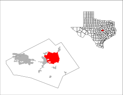
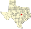
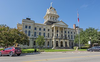
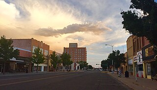
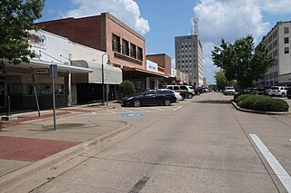
Belton is a city in the U.S. state of Texas. Belton is the county seat of Bell County and is the fifth largest city in the Killeen-Temple metropolitan area. In 2020, the population of Belton was 23,054, and the metro region had a population of 450,051 according to US Census estimates.

<span class="mw-page-title-main">Killeen, Texas</span> City in Texas, United States

Killeen is a city in the U.S. state of Texas, located in Bell County. According to the 2020 census, its population was 153,095, making it the 19th-most populous city in Texas and the largest of the three principal cities of Bell County. It is the principal city of the Killeen–Temple–Fort Cavazos Metropolitan Statistical Area. Killeen is 55 miles (89 km) north of Austin, 125 miles (201 km) southwest of Dallas, and 125 miles (201 km) northeast of San Antonio.

<span class="mw-page-title-main">Little River-Academy, Texas</span> City in Texas, United States

Little River-Academy is a city in Bell County, Texas, United States. The population was 1,992 at the 2020 census. It is part of the Killeen–Temple–Fort Hood Metropolitan Statistical Area.

<span class="mw-page-title-main">Brownwood, Texas</span> City in Texas, United States

Brownwood is a city in and the county seat of Brown County, Texas, United States. The population was 18,862 as of the 2020 census. Brownwood is located in the Northern Texas Hill Country and is home to Howard Payne University, which was founded in 1889.

<span class="mw-page-title-main">Gainesville, Texas</span> City in Texas, United States

Gainesville is a city in and the county seat of Cooke County, Texas, United States. Its population was 17,394 at the 2020 census. It is part of the Texoma region and is an important Agri-business center.

<span class="mw-page-title-main">Gatesville, Texas</span> City in Texas, United States

Gatesville is a city in and the county seat of Coryell County, Texas, United States. Its population was 16,135 at the 2020 census. The city has five of the nine prisons and state jails for women operated by the Texas Department of Criminal Justice. One of the facilities, the Patrick O'Daniel Unit, has the state's death row for women.

<span class="mw-page-title-main">Rosenberg, Texas</span> City in Texas, United States

Rosenberg is a city in the U.S. state of Texas, within the Houston–The Woodlands–Sugar Land metropolitan area and Fort Bend County. Rosenberg was named for Henry Von Rosenberg, who emigrated to Texas from Switzerland in 1843. Von Rosenberg was an important figure in the settlement of Fort Bend County and the Gulf Coast region. The population was 38,282 at the 2020 census, up from 30,618 at the 2010 census. The community holds the Fort Bend County fair in October. Rosenberg is adjacent to the city of Richmond, the Fort Bend County seat.

<span class="mw-page-title-main">Sherman, Texas</span> City in Texas, United States

Sherman is a city in and the county seat of Grayson County, Texas, United States. The city's population in 2020 was 43,645. It is one of the two principal cities in the Sherman–Denison metropolitan statistical area, and is the largest city in the Texoma region of North Texas and southern Oklahoma.

<span class="mw-page-title-main">Cleburne, Texas</span> City in Texas, United States

Cleburne is a city in and the county seat of Johnson County, Texas, United States. As of the 2020 census, its population was 31,352. The city is named in honor of Patrick Cleburne, a Confederate general. Lake Pat Cleburne, the reservoir that provides water to the city and surrounding area, is also named after him.

<span class="mw-page-title-main">Waco, Texas</span> City in Texas, United States

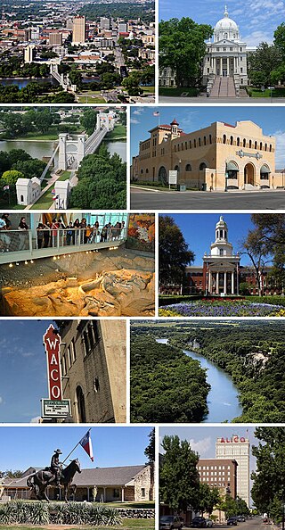
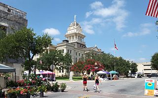
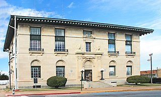
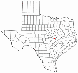
Waco is a city in and the county seat of McLennan County, Texas, United States. It is situated along the Brazos River and I-35, halfway between Dallas and Austin. The city had a U.S. census estimated 2022 population of 143,984, making it the 24th-most populous city in the state. The Waco metropolitan statistical area consists of McLennan, Falls and Bosque counties, which had a 2020 population of 295,782. Bosque County was added to the Waco MSA in 2023. The 2023 U.S. census population estimate for the Waco metropolitan area was 304,865 residents.

<span class="mw-page-title-main">Bartlett, Texas</span> City in Texas, United States

Bartlett is a city in Bell and Williamson counties in the U.S. state of Texas. The population was 1,633 at the 2020 census.

<span class="mw-page-title-main">Copperas Cove, Texas</span> City in Texas, United States

Copperas Cove is a city located in central Texas at the southern corner of Coryell County with smaller portions in Lampasas and Bell counties. Founded in 1879 as a small ranching and farming community, today the city is the largest in Coryell County, with 32,032 residents as of the 2010 census and an estimated 33,235 residents in 2019. The city's economy is closely linked to nearby Fort Cavazos, making it part of the Killeen-Temple-Fort Hood Metropolitan Statistical Area. Locals usually refer to the town as just "Cove".

<span class="mw-page-title-main">Grapevine, Texas</span> City in Texas, United States

Grapevine is a city located in northeast Tarrant County, Texas, United States, with minor portions extending into Dallas County and Denton County. The population was 50,631 at the time of the 2020 census, up from 46,334 in the 2010 census. The city is located in the Mid-Cities suburban region between Dallas and Fort Worth and includes a larger portion of Dallas/Fort Worth International Airport than other cities.

<span class="mw-page-title-main">Missouri City, Texas</span> City in Texas, United States

Missouri City is a city in the U.S. state of Texas, within the Houston–The Woodlands–Sugar Land metropolitan area. The city is mostly in Fort Bend County, with a small portion in Harris County. As of the 2020 census, the city had a population of 74,259, an increase over the figure of 67,358 tabulated in 2010.

<span class="mw-page-title-main">Longview, Texas</span> City in Texas, United States

Longview is a city in and county seat of Gregg County, Texas, United States. Longview is located in East Texas, where Interstate 20 and U.S. highways 80 and 259 converge just north of the Sabine River. According to the 2020 U.S. census, the city had a population of 81,638. Longview is the principal city of the Longview metropolitan statistical area, comprising Gregg, Upshur, and Rusk counties. The population of the metropolitan area as of 2021 census estimates was 287,858.

References

  1. "2019 U.S. Gazetteer Files". United States Census Bureau. Retrieved August 7, 2020.
  2. 1 2 "U.S. Census website". United States Census Bureau . Retrieved January 31, 2008.
  3. "US Board on Geographic Names". United States Geological Survey. October 25, 2007. Retrieved January 31, 2008.
  4. "Table 1. Annual Estimates of the Population of Metropolitan and Micropolitan Statistical Areas: April 1, 2000 to July 1, 2009 (CBSA-EST2009-01)". 2009 Population Estimates. United States Census Bureau, Population Division. March 23, 2010. Archived from the original on June 15, 2010. Retrieved March 25, 2010.
  5. Britanica. 1984 Edition. Vol. IX, p. 879
  6. "Poynette, Wisconsin". City of Temple History. Retrieved July 29, 2012.
  7. Texas State Historical Commission. "Temple, Texas Historical Marker".
  8. "Temple Railroad and Heritage Museum website". Rrhm.org. Archived from the original on July 23, 2011. Retrieved August 27, 2017.
  9. Bureau, U.S. Census. "U.S. Census website". United States Census Bureau . Retrieved August 27, 2017.
  10. Connelly, Michael, Robert McClure, and Melinda Reinke. "Into The Storm The Story Of Flight 191." South Florida Sun-Sentinel . July 27, 1986. p. 1 Archived August 5, 2015, at the Wayback Machine . Retrieved on August 3, 2015.
  11. "US Gazetteer Files 2016-Places-Texas". US Census. Retrieved January 12, 2017.
  12. "Monthly Averages for Temple, TX". Weather.com . The Weather Channel . Retrieved August 14, 2013.
  13. "QuickFacts: Temple city, Texas". U.S. Census Bureau.
  14. "Explore Census Data". data.census.gov. Retrieved May 24, 2022.
  15. https://www.census.gov/ [ not specific enough to verify ]
  16. "About the Hispanic Population and its Origin". www.census.gov. Retrieved May 18, 2022.
  17. "Feed My Sheep". Feed My Sheep. Retrieved August 27, 2017.
  18. "Home". Mclaneco.com. Retrieved August 27, 2017.
  19. "Texas Independent School District". Texas Independent School District. Retrieved August 5, 2012.
  20. "Geographic Information Systems School Map". City of Temple. Retrieved February 12, 2017.
  21. "St. Mary's Catholic School". St. Mary's Catholic School. Retrieved August 5, 2012.
  22. "Holy Trinity Catholic High School". Holy Trinity Catholic High School. Retrieved August 5, 2012.
  23. "Central Texas Christian School". Central Texas Christian School. Retrieved August 5, 2012.
  24. "Temple, Texas". Texas State Historical Association. Retrieved July 29, 2012.
  25. "FM Query Results". Federal Communications Commission . Retrieved February 12, 2017.
  26. "AM Query Results". Federal Communications Commission . Retrieved February 12, 2017.
  27. "Temple, Texas Radio Stations". Radio Lineup. Retrieved February 12, 2017.
  28. "Broadcast-Temple, TX". TVTV.us.
  29. "Temple, Texas Channel lineups". TVTV.com. Retrieved February 12, 2017.
  30. ftp://ftp.dot.state.tx.us/pub/txdot-info/stimulus/t_bone.pdf
  31. "Temple, Texas Mayor Bill Jones on "T-Bone" high speed rail". Trains4america.wordpress.com. June 18, 2009. Retrieved August 27, 2017.
  32. "Texas Awarded $5.6 M For High-Speed Rail Grant". Nbcdfw.com. Retrieved August 27, 2017.
  33. "Bryan City Council Gets Update On High Speed Rail Project". Kbtx.com. Retrieved August 27, 2017.
  34. "Contact Us Archived 2010-07-25 at the Wayback Machine ." Texas State Soil and Water Conservation Board. Retrieved on June 3, 2010.
  35. "Parole Division Region IV Archived 2011-09-04 at the Wayback Machine ." Texas Department of Criminal Justice. Retrieved on May 21, 2010.
  36. "Property Search Results > 110482 STATE OF TEXAS for Year 2017". Bell County Appraisal District. Retrieved February 12, 2017.
  37. Post Office Location – TEMPLE Archived 2010-05-22 at the Wayback Machine United States Postal Service. Retrieved on May 21, 2010.