Tengah, Singapore

Last updated

Tengah
Planning Area and future HDB town
Other transcription(s)
   Malay Tengah(Rumi)
   Chinese 登加
Dēngjiā(Pinyin)
Teng-ka(Hokkien POJ)
   Tamil தெங்கா
Teṅkā(Transliteration)
Tengah Plantation MRT station site 130622.jpg
Tengah New Town under construction in Mid-2022
Tengah location.svg
Location of Tengah in Singapore
Upcoming new estate townFlag of Singapore.svg  Singapore
Region West Region
CDC
Town council
  • Chua Chu Kang Town Council
Constituency
Government
  MayorSouth West CDC
  Members of ParliamentHong Kah North SMC
Area
[1]
  Total700 ha (1,700 acres)
Population
 (2023)Residents have started moving into Tengah since Aug 2023, so population figures may change.
  TotalNot confirmed
Demonym Singaporeans
not confirmed
not confirmed

Tengah is a planning area and future HDB town located within the West Region of Singapore. It is bound by Choa Chu Kang to the northeast, Jurong East and Jurong West to the south, Bukit Batok to the east and the Western Water Catchment to its west and north.

Contents

Formerly a military restricted area, Tengah is currently reserved for new housing developments, making it Singapore's newest Housing and Development Board town since the development of Punggol in the late-90s. [2]

After the demilitarisation of the military training area at Tengah, the first estate, Plantation Grove, was launched in Tengah in November 2018. [3] Tengah is divided into various districts, namely Plantation, Park, Garden, Market Place, Forest Hill and Brickland Districts.

The southwestern portion of Tengah will be developed as part of the Jurong Innovation District(or Jurong lake district) , a newer industrial development compared to Jurong Industrial Estate.

Etymology

In the old maps, the area appears as Tengeh or Tengah. In Malay, the word Tengah means "centre", "central" or "middle". The name may be taken from the nearby Sungei Tengah (Malay for Tengah River).[ citation needed ]

History

In the 1980s, under the government's resettlement plan, the residents of Hong Kah Village and Kampong Ulu Jurong were relocated to nearby towns newly built by the government, particularly into the present Jurong Green, Jurong Spring and Bukit Batok areas. Schools were shifted elsewhere and one example is Xingnan Primary School, which used to operate at a temple along "Hong Kah Road" at the village. The HDB estates of Jurong Green and Jurong Spring are given the name "Hong Kah", probably meaning that most of the villagers resettled there. When the village was cleared, the PIE and KJE projects started in the area, leading to the creation of "Jurong West Avenue 2" that brought about the rise of both Jurong West New Town and Choa Chu Kang New Town. The western part became inaccessible to the public first in 1996 and was used by the military for training activities (which is west of Jurong Road Track 22), followed by the eastern part of Hong Kah (which is east of Jurong Road Track 22) in 2005.

In the past, there were several village roads that used to serve the area. Roads such as Hong Kah Road/Lane/Drive/Circle, Sing Nan Road, Kian Hong Road, Jalan Keladan, Jalan Beka, Jalan Pelawan, Jalan Jelawi, Jalan Sena, Lorong Putek, Jalan Buey, Jalan Mandar and Jalan Ara. The last few roads, such as Jalan Lam Sam and Jalan Chichau existed till January 2019. Jurong Road closed on 27 September 2020 and is being replaced by Tengah Way and Tengah Drive.

In late 2018, massive construction works for the HDB estates started in Tengah C1 & C2 planning areas, which is estimated to be completed by 2025. Most of the construction works will be headed by China Construction (South Pacific) Pte Ltd whereas few other local construction firms will also be in charge of construction works. The HDB flats in Tengah are constructed via precast components. The first flats in Tengah were completed in 2023 and the neighbourhood centre which would be connected to West Edge @ Bukit Batok via an overhead pedestrian bridge will be completed by the mid-2020s.

Sustainability

Tengah was marketed as Singapore's first smart and sustainable town with a centralised cooling system which is managed by national grid operator SP Group. [4] The cooling system encountered issues with installation and operational issues. [4]

It is also the only town in Singapore which has a car-free town centre. [2] Various types of dense vegetation are planted along roads to serve as noise and visual barriers, providing a cleaner, greener living environment.

Eco-friendly features in Tengah include bioswales and bioretention basins (or rain gardens), which will collect and cleanse the rainwater before it is stored for reuse within the development or channelled into reservoirs. Such water features also create a conducive habitat for dragonflies and amphibians, which add to the biodiversity of the town and help promote a healthy ecological balance.

Transport

Prior to 24 September 2023, the transport options was limited to a Tengah free shuttle bus provided by the government.

Tengah will be connected to the Jurong Region MRT line in 2027, with MRT stations Tengah, Tengah Plantation and Tengah Park servicing the area, and a new integrated transport hub to be ready by 2027. [5] Currently, bus services 870 and 992 are the only bus services that serve the interior of Tengah. [6] [7]

All roads in Tengah will have walking and cycling paths on both sides. [2]

Military use

The bigger part of the former Hong Kah Village was an SAF military training area until 10 November 2015. The military training around the area was gradually shifted to Ama Keng Road and training for Keat Hong Camp were now trained at Ama Keng. Massive construction and earthworks subsequently began in October 2017.

Related Research Articles

<span class="mw-page-title-main">Jurong</span> Commercial district and Regional centre in West Region, Singapore

Jurong is a major geographical region located at the south-westernmost point of the West Region of Singapore. Although mostly vaguely defined, the region's extent roughly covers the planning areas of Jurong East, Jurong West, Boon Lay, and Pioneer, along with Jurong Island in the Western Islands cluster and the southernmost portions of the Western Water Catchment. Should it be described at its greatest historical extent, the region can also include present-day Bukit Batok and Tuas.

<span class="mw-page-title-main">Clementi, Singapore</span> Planning Area and HDB Town in West Region, Singapore

Clementi is a planning area and residential town located at the easternmost fringe of the West Region of Singapore. The town borders Bukit Batok to the north, Bukit Timah to the northeast, Queenstown to the east and Jurong East to the west.

<span class="mw-page-title-main">Choa Chu Kang</span> Planning area and residential town in Singapore

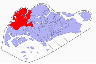
Choa Chu Kang, alternatively spelled Chua Chu Kang and often abbreviated as CCK, is a planning area and residential town located at the northwestern point of the West Region of Singapore. The town shares borders with Sungei Kadut to the north, Tengah to the southwest, Bukit Batok to the southeast, Bukit Panjang to the east and the Western Water Catchment to the west. Choa Chu Kang New Town is separated into two portions by the Kranji Expressway.

<span class="mw-page-title-main">Lim Chu Kang</span> Planning Area in North Region, Singapore

Lim Chu Kang is a planning area located in the northwestern part of the North Region of Singapore, bordering the Western Water Catchment to the west and south, Sungei Kadut to the east and the Straits of Johor to the north.

<span class="mw-page-title-main">Bukit Batok</span> Planning Area and HDB Town in West Region ----, Singapore

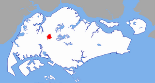
Bukit Batok, often abbreviated as Bt Batok, is a planning area and matured residential town located along the eastern boundary of the West Region of Singapore. Bukit Batok statistically ranks in as the 25th largest, the 12th most populous and the 11th most densely populated planning area in Singapore. It is bordered by six other planning areas - Choa Chu Kang to the North, Northeast and Northwest, Cashew to the northeast and East, Clementi to the South, Bukit Timah to the southeast, Jurong East to the southwest and Tengah to the west.

<span class="mw-page-title-main">Jurong East</span> Planning Area and Regional Centre in West Region, Singapore

Jurong East is a planning area and residential town situated in the West Region of Singapore. It borders Jurong West and Boon Lay to the west, Clementi to the east, Tengah and Bukit Batok to the north and Selat Jurong to the south.

<span class="mw-page-title-main">Boon Lay</span> Place in Singapore

Boon Lay is a neighbourhood located in the town of Jurong West in the West Region of Singapore. Its borders very roughly correspond to the URA subzone of Boon Lay Place, situated within the Jurong West Planning Area.

<span class="mw-page-title-main">Jurong West</span> Residential town in the West Region of Singapore

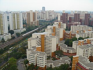
Jurong West is a planning area and residential town located in the West Region of Singapore. Jurong West shares boundaries with Tengah in the north, Jurong East in the east, Boon Lay and Pioneer in the south, and Western Water Catchment in the west.

<span class="mw-page-title-main">Bukit Gombak</span> Place in Singapore

Bukit Gombak is a subzone of Bukit Batok, Singapore. It is a hilly neighbourhood in the west-central area of the Southeast Asian city-state of Singapore. In the Malay language, bukit means hill and gombak a bunch or collection of something. The neighbourhood consists of two hills. One of them stands at 133m while the other stands at 113m. They are Singapore's second and third highest natural point after Bukit Timah Hill.

The Jurong Police Division is one of the seven land divisions of the Singapore Police Force. Jurong Division first came into existence as the ‘Rural West’ Division on 24 Sep 1965 and operated from a standalone building located at Bukit Panjang. As the communities in the west grew, police posts were built in Ama Keng, Mandai and Kranji.

<span class="mw-page-title-main">Hong Kah Group Representation Constituency</span> Electoral division in western Singapore

Hong Kah Group Representation Constituency was a five-member Group Representation Constituency located in the western area of Singapore. The constituency covered the areas of Bukit Batok, Choa Chu Kang, Upper Bukit Timah, Jurong West and Lim Chu Kang. Hong Kah GRC was formed in 1988 and eventually dissolved and reformed into Chua Chu Kang GRC in 2011. It had always been held by the People's Action Party.

<span class="mw-page-title-main">Future developments in Singapore</span>

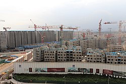
This article shows the notable future developments in Singapore. Most of them are currently under construction with most to be completed within the next five years.

<span class="mw-page-title-main">Western Water Catchment</span> Planning Area in West Region ----, Singapore

The Western Water Catchment is a planning area located in the West Region of Singapore. The planning area borders Tuas and Pioneer to its south, Sungei Kadut, Choa Chu Kang and Tengah to its east, Jurong West to its southeast, Lim Chu Kang to its north and the Straits of Johor to its west. It is the largest planning area by land area, covering nearly a tenth of Singapore Island. It is also one of the two main water catchments in Singapore, the other being Central Water Catchment.

Jurong Road was a small road near Tengah in western Singapore.

Choa Chu Kang Road is a road in Singapore in two sections.

Wenya is a subzone of Jurong West, Singapore.

<span class="mw-page-title-main">Choa Chu Kang MRT/LRT station</span> Mass Rapid Transit and light rail station in Singapore

Choa Chu Kang MRT/LRT station is an above-ground Mass Rapid Transit (MRT) and Light Rail Transit (LRT) interchange station in Choa Chu Kang, Singapore. It is an interchange between the North South line and Bukit Panjang LRT, serving as the western terminus of the latter. The station is located between Choa Chu Kang Bus Interchange and Lot One in the Choa Chu Kang town centre.

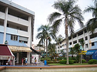
Hong Kah is a residential precinct in Jurong West, Singapore. It is bounded by the PIE, Corporation Road, Jurong Canal Drive, Jurong East Avenue 1 and Jurong Town Hall Road. It is named after the former 'Hong Kah Village'.

Brickworks is a subzone of Bukit Batok, Singapore. It is bounded by Bukit Batok West Avenue 3/2/5 and Bukit Batok Road and is beside the upcoming New Town, Tengah. It is the latest development area in Bukit Batok.

<span class="mw-page-title-main">Tengah Plantation MRT station</span> Future Mass Rapid Transit station in Singapore

Tengah Plantation MRT station is a future elevated Mass Rapid Transit (MRT) station on the Jurong Region line in Tengah, Singapore.

References

  1. Kenneth Cheng (8 September 2016). "A peek into Tengah, the next new HDB town the size of Bishan". Today.
  2. 1 2 3 Heng, Janice (8 September 2016). "Tengah, the first HDB town since Punggol, to have forest fringe, car-free town centre". The Straits Times. ISSN   0585-3923 . Retrieved 18 December 2023.
  3. "HDB launches 7,214 BTO flats, including first project in Tengah". Channel NewsAsia. 13 November 2018. Retrieved 25 January 2020.
  4. 1 2 "'Feels like a fan': Tengah home owners raise more issues with new centralised cooling system". CNA. Retrieved 18 December 2023.
  5. Auto, Hermes (4 February 2021). "Jurong East integrated transport hub construction to begin this year, 12 years after first mention | The Straits Times". www.straitstimes.com. Retrieved 26 April 2023.
  6. "Two new bus services for residents in Tengah and Bukit Batok West to operate from Sept 24". The Straits Times .
  7. "Tengah to get new bus service, two route extensions after complaints from residents". The Straits Times .