
Horná Ždaňa is a village and municipality in Žiar nad Hronom District in the Banská Bystrica Region of central Slovakia.

Hohenzollernplatz is an U-Bahn station in Munich on the U2. The station is also served by routes and of the Munich tramway.
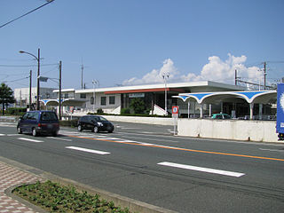
Araimachi Station is a railway station on the Tōkaidō Main Line of Central Japan Railway Company in Kosai City, Shizuoka Prefecture, Japan. The station is 272.9 rail kilometers from Tokyo.

Rogale is a village in the administrative district of Gmina Księżpol, within Biłgoraj County, Lublin Voivodeship, in eastern Poland. It lies approximately 6 kilometres (4 mi) north of Księżpol, 9 km (6 mi) south of Biłgoraj, and 87 km (54 mi) south of the regional capital Lublin.

Zəfəran is a village in Baku, Azerbaijan.
Zakrzew is a village in the administrative district of Gmina Biała Rawska, within Rawa County, Łódź Voivodeship, in central Poland. It lies approximately 4 kilometres (2 mi) north of Biała Rawska, 17 km (11 mi) north-east of Rawa Mazowiecka, and 70 km (43 mi) east of the regional capital Łódź.
Wólka Klonowska is a village in the administrative district of Gmina Brąszewice, within Sieradz County, Łódź Voivodeship, in central Poland. It lies approximately 2 kilometres (1 mi) east of Brąszewice, 22 km (14 mi) south-west of Sieradz, and 76 km (47 mi) south-west of the regional capital Łódź.
Podlodów is a village in the administrative district of Gmina Ulhówek, within Tomaszów Lubelski County, Lublin Voivodeship, in eastern Poland, close to the border with Ukraine.
Rokitno is a village in the administrative district of Gmina Ulhówek, within Tomaszów Lubelski County, Lublin Voivodeship, in eastern Poland, close to the border with Ukraine. It lies approximately 3 kilometres (2 mi) north of Ulhówek, 27 km (17 mi) east of Tomaszów Lubelski, and 121 km (75 mi) south-east of the regional capital Lublin.
Drutarnia is a village in the administrative district of Gmina Końskie, within Końskie County, Świętokrzyskie Voivodeship, in south-central Poland. It lies approximately 5 kilometres (3 mi) east of Końskie and 38 km (24 mi) north of the regional capital Kielce.
Trzcianka-Kolonia is a colony in the administrative district of Gmina Osiek, within Staszów County, Świętokrzyskie Voivodeship, in south-central Poland. It lies approximately 6 kilometres (4 mi) south-west of Osiek, 20 km (12 mi) south-east of Staszów, and 72 km (45 mi) south-east of the regional capital Kielce.
Wieczfnia-Kolonia is a village in the administrative district of Gmina Wieczfnia Kościelna, within Mława County, Masovian Voivodeship, in east-central Poland.
Osiek is a village in the administrative district of Gmina Koziegłowy, within Myszków County, Silesian Voivodeship, in southern Poland. It lies approximately 6 kilometres (4 mi) south-east of Koziegłowy, 7 km (4 mi) west of Myszków, and 39 km (24 mi) north-east of the regional capital Katowice.
Pędziszewo is a village in the administrative district of Gmina Debrzno, within Człuchów County, Pomeranian Voivodeship, in northern Poland. It lies approximately 9 kilometres (6 mi) north-west of Debrzno, 19 km (12 mi) south-west of Człuchów, and 133 km (83 mi) south-west of the regional capital Gdańsk.
Wielbrandowo is a village in the administrative district of Gmina Skórcz, within Starogard County, Pomeranian Voivodeship, in northern Poland.
Indianópolis, Paraná is a municipality in the state of Paraná in the Southern Region of Brazil.

Kampala Hill, commonly referred to as Old Kampala, is a hill in the center of Kampala, Uganda's capital and largest city.

Mihoub is a town and commune in Médéa Province, Algeria. According to the 1998 census, it has a population of 11488.
Nehatu is a village in Lääneranna Parish, Pärnu County, in western Estonia.
The Simiganj River is a short, 24.5 km, river in western Tajikistan, central Asia.


