Terenzo

Last updated
Terenzo
Comune
Comune di Terenzo

Castello-Di-Casola-Overview.JPG

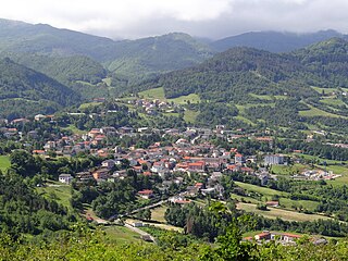
The village of Castello di Casola in Terenzo
Italy provincial location map 2015.svg
Red pog.svg
Terenzo
Location of Terenzo in Italy
Coordinates: 44°37′N10°5′E / 44.617°N 10.083°E / 44.617; 10.083 Coordinates: 44°37′N10°5′E / 44.617°N 10.083°E / 44.617; 10.083
Country Italy
Region Emilia-Romagna
Province Province of Parma (PR)
Frazioni Bardone, Boschi di Bardone, Case Castellani, Cassio, Castello, Castello di Casola, Cazzola, Corniana, Goiano, Lesignano Palmia, Lughero, Palmia, Puilio, Selva Grossa, Stazione Bocchetto, Villa, Villa di Casola, Viola
Area
  Total 72.4 km2 (28.0 sq mi)
Population (Dec. 2004)
  Total 1,250
  Density 17/km2 (45/sq mi)
Time zone CET (UTC+1)
  Summer (DST) CEST (UTC+2)
Postal code43040
Dialing code 0525
Website Official website

Terenzo (Parmigiano: Tréns) is a comune (municipality) in the Province of Parma in the Italian region Emilia-Romagna, located about 100 kilometres (62 mi) west of Bologna and about 30 kilometres (19 mi) southwest of Parma. As of 31 December 2004, it had a population of 1,250 and an area of 72.4 square kilometres (28.0 sq mi). [1]

The Parmigiano dialect, sometimes the Parmesan dialect, is a dialect of the Emilian language spoken in the Province of Parma, the western-central portion of the Emilia-Romagna administrative region.

<i>Comune</i> third-level administrative divisions of the Italian Republic

The comune is a basic administrative division in Italy, roughly equivalent to a township or municipality.

Province of Parma Province of Italy

The Province of Parma is a province in the Emilia-Romagna region of Italy. Its largest town and capital is the city of Parma.

Contents

The municipality of Terenzo contains the frazioni (subdivisions, mainly villages and hamlets) Bardone, Boschi di Bardone, Case Castellani, Cassio, Castello, Castello di Casola, Cazzola, Corniana, Goiano, Lesignano Palmia, Lughero, Palmia, Puilio, Selva Grossa, Stazione Bocchetto, Villa, Villa di Casola, and Viola.

"Frazione" is the Italian name given in administrative law to a type of territorial subdivision of a comune; for other administrative divisions, see municipio, circoscrizione, quartiere. It is cognate to the English word fraction, but in practice is roughly equivalent to "parishes" or "wards" in other countries.

At the foot of Monte Zirone, is the slender former church or Pieve di San Michele di Corniana, dedicate to St Michael Archangel. Also nearby is the Pieve di Bardone, completed prior to 13th-century.

Terenzo borders the following municipalities: Berceto, Calestano, Fornovo di Taro, Sala Baganza, Solignano.

Berceto Comune in Emilia-Romagna, Italy

Berceto is a village and comune in Italy, located in the Apennine Mountains on the main road between La Spezia and Parma, in the Taro River valley, in the region of Emilia-Romagna.

Calestano Comune in Emilia-Romagna, Italy

Calestano is a comune (municipality) in the Province of Parma in the Italian region Emilia-Romagna, located about 100 kilometres (62 mi) west of Bologna and about 30 kilometres (19 mi) southwest of Parma.

Fornovo di Taro Comune in Emilia-Romagna, Italy

Fornovo di Taro is a comune (municipality) in the province of Parma, in the Italian region Emilia-Romagna, located about 100 kilometres (62 mi) west of Bologna and about 25 kilometres (16 mi) southwest of Parma. The town lies on the east bank of the Taro River.

Demographic evolution

Terenzo

Related Research Articles

Castello-Molina di Fiemme Comune in Trentino-Alto Adige/Südtirol, Italy

Castello-Molina di Fiemme is a comune (municipality) in Trentino in the northern Italian region Trentino-Alto Adige/Südtirol, located about 35 km (22 mi) northeast of Trento. As of 31 December 2004, it had a population of 2,172 and an area of 54.5 km2 (21 sq mi).

Pieve Tesino Comune in Trentino-Alto Adige/Südtirol, Italy

Pieve Tesino is a comune (municipality) in Trentino in the northern Italian region Trentino-Alto Adige/Südtirol, located about 40 kilometres (25 mi) east of Trento.

Scurelle Comune in Trentino-Alto Adige/Südtirol, Italy

Scurelle is a comune (municipality) in Trentino in the northern Italian region Trentino-Alto Adige/Südtirol, located about 30 kilometres (19 mi) east of Trento. As of 31 December 2004, it had a population of 1,322 and an area of 29.9 square kilometres (11.5 sq mi).

Telve Comune in Trentino-Alto Adige/Südtirol, Italy

Telve is a comune (municipality) in Trentino in the northern Italian region Trentino-Alto Adige/Südtirol, located about 30 kilometres (19 mi) east of Trento. As of 31 December 2004, it had a population of 1,914 and an area of 64.8 square kilometres (25.0 sq mi).

Almenno San Salvatore Comune in Lombardy, Italy

Almenno San Salvatore is a comune (municipality) in the Province of Bergamo in the Italian region Lombardy, located about 45 kilometres (28 mi) northeast of Milan and about 9 kilometres (6 mi) northwest of Bergamo.

Rivergaro Comune in Emilia-Romagna, Italy

Rivergaro is a comune (municipality) in the Province of Piacenza in the Italian region Emilia-Romagna, located about 150 kilometres (93 mi) northwest of Bologna and about 20 kilometres (12 mi) southwest of Piacenza. As of 31 December 2011, it had a population of 6,843 and an area of 43.8 square kilometres (16.9 sq mi).

Neviano degli Arduini Comune in Emilia-Romagna, Italy

Neviano degli Arduini is a comune (municipality) in the Province of Parma in the Italian region Emilia-Romagna, located about 80 kilometres (50 mi) west of Bologna and about 25 kilometres (16 mi) south of Parma.

Sala Baganza Comune in Emilia-Romagna, Italy

Sala Baganza is a comune (municipality) in the Province of Parma in the Italian region Emilia-Romagna, located about 90 kilometres (56 mi) northwest of Bologna and about 12 kilometres (7 mi) southwest of Parma.

Torrile Comune in Emilia-Romagna, Italy

Torrile is a comune (municipality) in the Province of Parma in the Italian region Emilia-Romagna, located about 90 kilometres (56 mi) northwest of Bologna and about 13 kilometres (8 mi) north of Parma.

Castello dArgile Comune in Emilia-Romagna, Italy

Castello d'Argile is a comune (municipality) in the Metropolitan City of Bologna in the Italian region Emilia-Romagna, located about 20 kilometres (12 mi) north of Bologna.

Mercatello sul Metauro Comune in Marche, Italy

Mercatello sul Metauro is a comune (municipality) in the Province of Pesaro e Urbino in the Italian region Marche, located about 100 kilometres (62 mi) west of Ancona and about 50 kilometres (31 mi) southwest of Pesaro.

Casola in Lunigiana Comune in Tuscany, Italy

Casola in Lunigiana is a comune (municipality) in the Province of Massa and Carrara in the Italian region Tuscany, located about 100 kilometres (62 mi) northwest of Florence and about 20 kilometres (12 mi) north of Massa.

Pieve Fosciana Comune in Tuscany, Italy

Pieve Fosciana is a comune (municipality) in the Province of Lucca in the Italian region Tuscany, located about 80 kilometres (50 mi) northwest of Florence and about 30 kilometres (19 mi) north of Lucca.

Villa Collemandina Comune in Tuscany, Italy

Villa Collemandina is a comune (municipality) in the Province of Lucca in the Italian region Tuscany, located about 80 kilometres (50 mi) northwest of Florence and about 35 kilometres (22 mi) north of Lucca.

Signa Comune in Tuscany, Italy

Signa is a comune (municipality) in the Metropolitan City of Florence in the Italian region Tuscany, located about 12 kilometres (7 mi) west of Florence.

Castelnuovo Berardenga Comune in Tuscany, Italy

Castelnuovo Berardenga is a comune (municipality) in the province of Siena in the Italian region Tuscany, located about 50 kilometres (31 mi) southeast of Florence and about 14 kilometres (9 mi) east of Siena. Since 1932 it is included in the Chianti wine-production area.

Gaiole in Chianti Comune in Tuscany, Italy

Gaiole in Chianti is a comune (municipality) in the Province of Siena in the Italian region Tuscany, located about 40 kilometres (25 mi) southeast of Florence and about 15 kilometres (9 mi) northeast of Siena. Forbes named it number one in its list of "Europe's Most Idyllic Places To Live."

Casola di Napoli Comune in Campania, Italy

Casola di Napoli is a comune (municipality) in the Metropolitan City of Naples in the Italian region Campania, located about 30 kilometres (19 mi) southeast of Naples.

Casola is a village in Italy in the Province of Parma, in the Emilia-Romagna region. It is more than 3 kilometers from the town of Terenzo which it is part of.

References

  1. All demographics and other statistics: Italian statistical institute Istat.