
Trujillo State is one of the 23 states of Venezuela. Its capital is Trujillo but the largest city is Valera. The state is divided into 20 municipalities and 93 parishes. Trujillo State covers a total surface area of 7,198 km² and, has a 2011 census population of 686,367.

Pedro José Ramón Gual, was a Venezuelan lawyer, politician, journalist and diplomat.

Cerro Las Tetas, nicknamed Las Tetas de Cayey, but officially Cerro Las Tetas, and also Las Piedras del Collado, are two mountain peaks located in the municipality of Salinas, Puerto Rico, north of the city of Salinas proper. Since September 1, 2000, the peaks have become part of a Puerto Rico Natural Reserve and are protected by law. Their height is 2,762 feet (842 m) above sea level.
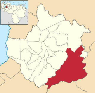
Boconó is a city in the Venezuelan Andean state of Trujillo. Founded in 1560, this city is the shire town of the Boconó Municipality and, according to the 2001 Venezuelan census, the municipality has a population of 79,710.
A Bien de Interés Cultural is a category of the heritage register in Spain. The term is also used in Venezuela, and other Spanish-speaking countries.

The Venezuelan Andes also simply known as the Andes in Venezuela, are a mountain system that form the northernmost extension of the Andes. They are fully identified, both by their geological origin as by the components of the relief, the constituent rocks and the geological structure.

A breast-shaped hill is a mountain in the shape of a woman's breast. Some such hills are named "Pap", a word for the breast or nipple. Such anthropomorphic geographic features are to be found in different places of the world and in some cultures they were revered as the attributes of the Mother Goddess, such as the Paps of Anu, named after Anu, an important female deity of pre-Christian Ireland.

The Cerro El Copey National Park Also Cerro El Copey-Jóvito Villalba National Park Is a protected area with the status of a national park located to the east of the Caribbean island of Margarita, in the highest mountainous region of Nueva Esparta State in Venezuela. It was created in 1974 with the purpose of protecting an outstanding physiographic feature with an ecosystem that includes several plant formations, high levels of endemism and the only permanent water sources of the island.

The Piedra del Cocuy Natural Monument Is a natural protected area located in the Río Negro municipality, in the state of Amazonas, Venezuela. It received the status of natural monument by decree No. 2,986 dated December 12, 1978, published in Official Gazette 2.417-E dated March 7, 1979.

The Arístides Rojas Natural Monument Also Morros de San Juan Is a protected natural space located in the Guárico State in the north-center of the South American country of Venezuela. It is a system of limestone rock formed by the deposition of marine sediments. It is located in the neighborhood of San Juan de Los Morros.

The Cerro María Lionza Natural Monument Also Montaña de Sorte Natural Monument Is a protected area with the status of a natural monument that is formed by a mountainous massif from which the river Yaracuy, Chorro and Charay are born, which together with the rivers Gurabao, Buria, Turbio and others, from which the reservoir of The Majaguas. This Monument is located within the Tropical Humid Forest Life Zone in Yaracuy State in northern Venezuela.

The Cerro Santa Ana Natural Monument Is a protected area with a natural monument status located in the center of the Paraguaná peninsula north of the Falcón state in the jurisdiction of the municipalities Falcón and Carirubana, between the populations of Santa Ana and Buena Vista, in the South American country of Venezuela. It has an area of 1900 hectares and a maximum height of 830 masl. It was declared Natural Monument on June 14, 1972 according to Decree No. 1.005, under the protection of INPARQUES.

The Cueva Alfredo Jahn Natural Monument Also Alfredo Jahn Cave Natural Monument or Tapa de Cambural Cave It is a protected area with the status of a natural monument that is located 4 km west of the town of Birongo, Miranda State, at the eastern end of the Coastal Range of the Cordillera de la Costa. With a 4.29 km gallery development, it is the largest cave in central Venezuela, the sixth in Venezuela and one of the most visited in the country.

The Cerro Platillón Natural Monument Also Pico Platillón It is a protected area with the status of natural monument that consists of a mountain formation located in the extreme north of the Guárico state, Venezuela. At an official height of 1,930 msnm2 Pico Platillón is the highest mountain in Guárico. It is protected as per decree published in Official Gazette of Venezuela, No. 33,664 of February 20, 1987.

The Loma de León Natural Monument Also Loma de León Is a natural protected area located in the municipality of Iribarren, belonging to the state of Lara, Venezuela. It received the status of national monument on February 2, 1987.

The Formaciones de Tepuyes Natural Monument also known as tepui Also Formaciones de Tepuyes Is a protected natural space since 1991, located in Venezuela more specifically in the states of Amazonas and Bolívar. Should not be confused with the Canaima national park that contains part of the tepuyes.

The Pico Codazzi Natural Monument Also Codazzi Peak Natural Monument Is a protected area with the status of a natural monument located in the Aragua State in the center of northern Venezuela. It was created in 1991 to connect the Henri Pittier National Park with the Macarao National Park and constitutes one of the highest peaks of the Cordillera de la Costa. It covers an area of 11,850 ha.

The Meseta la Galera Natural Monument Also La Galera Plateau Is a protected area with the status of a natural monument consisting of a mountainous formation of the state of Mérida in the Andes of the South American country of Venezuela, in the form of Tepuy level plate of approximately 1 km in length. It has an area of 95 ha and has a height of 1055 msnm at its highest point and 935 m.s.n.m. At its lowest point is located between the parishes of El Llano and Tovar in the city center of the city separating this one from the Mocotíes River and the Hill "Loma de La Virgen".

The Piedra La Tortuga Natural Monument Also Piedra La Tortuga Is a protected natural space located in the Atures municipality, in the Amazonas state, in the south of Venezuela. Received the status of natural monument by decree No. 2.351 of June 5, 1992. Official Gazette No. 35089 of November 11, 1992.


