Thai Canal

Last updated

Proposed Thai Canal routes Thai Canal map-de.jpg
Proposed Thai Canal routes

The Thai Canal, also known as Kra Canal or Kra Isthmus Canal, is any of several proposals for a canal that would connect the Gulf of Thailand with the Andaman Sea across the Kra Isthmus in southern Thailand. Such a canal would significantly reduce travel times through heavily-navigated trade routes.

Contents

The canal would provide an alternative to transit through the Straits of Malacca and shorten transit for shipments of oil to Japan and China by 1,200 km. [1] China refers to it as part of its 21st century maritime Silk Road. Proposals, as of 2015, measure 102 kilometres long, 400 meters wide and 25 meters deep. Plans for a canal have been discussed and explored at various times. [2] Cost, environmental concerns, and geopolitical concerns have been weighed against the potential economic and strategic benefits.

In February 2018, Thailand's Prime Minister Prayut Chan-o-cha declared that the canal was not a government priority. [3] However, on 16 January 2020, the Thai House of Representatives agreed to set up a committee within 120 days to study the Thai Canal project. [2]

History

A canal through the Kra Isthmus, which would shorten shipping times around Asia, was suggested as early as 1677. Thai King Narai asked the French engineer de Lamar to survey the possibility of building a waterway to connect Songkhla with Marid (now Myanmar), but the idea was discarded as impractical with the technology of that time. [4]

In 1793, the idea resurfaced. Maha Sura Singhanat, the younger brother of King Chakri (Rama I), suggested it would make it easier to protect the west coast with military ships. In the early-19th century, the British East India Company became interested in a canal. After Burma became a British colony in 1863, an exploration was undertaken with Victoria Point (Kawthaung) opposite the Kra estuary as its southernmost point, again with negative result. In 1882, the constructor of the Suez canal, Ferdinand de Lesseps, visited the area, but the Thai king did not allow him to investigate in detail. In 1897, Thailand and the British empire agreed not to build a canal so that the regional dominance of the harbour of Singapore would be maintained.

In 1946, Thailand and the United Kingdom signed the Anglo-Thai Peace Treaty, ending the state of war between the two countries during the Second World War. Out of the many concessions made in the treaty, one of the articles forbid the Thais from digging a canal across the Kra isthmus without British government permission. [5] [6]

As there was no progress on a canal, the construction of a road for cargo across the isthmus was started in 1993. Such a large highway was built, but because the location of the harbours was not set, Highway 44 does not yet end at the sea. Its sets of lanes are 150 m apart to leave space for railway and a pipeline. As of 2020, the highway runs from 8°18.11′N98°47.03′E / 8.30183°N 98.78383°E / 8.30183; 98.78383 to 9°9.47′N99°31.02′E / 9.15783°N 99.51700°E / 9.15783; 99.51700 .

Geography

The width of the Kra Isthmus at its minimum is only 44 km (27 mi), but the height of the intervening hills is 75 m (246 ft). The Panama Canal has a length of 77 km (48 mi), but highest point at the Culebra Cut was only 64 m (210 ft). The Panama Canal passes this point at a height of 12 m (39 ft) (canal bottom) and 26 m (85 ft) (water line), thus ships have to be lifted with locks to a height of 26 m (85 ft) above the ocean. The Suez Canal is 192 km (119 mi) long but passes entirely through a flat area (which was historically flooded by seas before). At a depth of 25 m (82 ft) below sea level the width of the Kra Isthmus is about 200 km (120 mi). [7] [ failed verification ] At 50 m (160 ft) below sea level this becomes about 400 km (250 mi). [8] [ failed verification ]

Several canal routes have been proposed: The original Kra Canal was envisioned as cutting through the Kra Isthmus between Ranong and Chumphon, the narrowest part of the South, a distance of about 50 kilometres. [2] Other routes proposed include a route in southern Thailand connecting Bandon Bay near Surat Thani with Phang Nga Province. Another is across Nakhon Si Thammarat Province and Trang Province. The seemingly preferred version of the Kra Canal project—Route 9A—would dig through Krabi, Trang, Phattalung, Nakhon Si Thammarat and Songkhla, a distance of 128 kilometres. [2] [9] Variation Route 5A would have ships enter the canal at Pak Bara in Satun Province. Another route would see ships entering a 135 km long canal at Sikao in Trang. [10]

Rationale

The idea of a Kra Canal has been proposed in modern times since the 1930s, but has never materialized due to high cost and environmental repercussions. [11]

The Strait of Malacca, just under 1,000 kilometres (620 mi) long, is narrow, less than 2.5 kilometres (1.6 mi) at the narrowest, and just 25 metres (82 ft) deep at its shallowest point. It is used by many oil tankers, bulk carriers and container ships. It is estimated that some 80% of Japan's and South Korea's oil and natural gas supplies pass through it. The strait, the world's busiest shipping route, saw a record 84,000 vessels sail through it in 2016. [12] Its yearly capacity is 120,000 vessels. The Maritime Institute of Malaysia forecasts that by 2025, about 140,000 vessels and freighters will seek to transit the strait. A canal would reduce shipping times between the South China Sea and the Andaman Sea two or three days and reduce distance travelled by at least 1,200 kilometres compared with the strait. [12] Bunker fuel savings for a 100,000 dwt (deadweight) oil tanker could be as much as US$350,000 per trip. [13]

In early 2015, calls for yet another feasibility study of the canal were put forward, a leading proponent being the Thai-Chinese Culture and Economic Association of Thailand (TCCEAT). Supporters of the canal believe that it would end Thailand's economic slump and make it a "global shipping and economic hub, rivalling the Panama Canal". [14] On 15 May 2015, a memorandum of understanding was signed by the China-Thailand Kra Infrastructure Investment and Development company (中泰克拉基础设施投资开发有限公司) in Guangzhou to advance the project. [15] [16] On 19 May 2015 the Thai government denied reports that an agreement had been signed with China to construct the canal. The canal would take an estimated ten years to complete at a cost of US$28 billion.

In 2005, an internal report prepared for U.S. Secretary of Defense Donald Rumsfeld was leaked to The Washington Times , spelling out China's strategy of underwriting construction of the canal across the Kra Isthmus, with Chinese port facilities and refineries, as part of its "string of pearls" strategy of forward bases and energy security. [17] The Chinese plan called for construction over ten years employing roughly 30,000 workers at a cost of between US$20–25 billion. [18]

Canal opponents have raised several objections to the construction of a canal:

  1. A canal will divide the country physically and pose a security risk. It is feared that a canal would separate the four southernmost provinces from the rest of Thailand and allow secessionist movements to further develop; [19] [20]
  2. Demand for transit will not meet expectations.
  3. The excavated soil will need to be dealt with.
  4. Environmental concerns. [21]

Potential regional impact

The canal would compete directly with ports in the Strait of Malacca area, including Port Klang, Tanjung Pelepas, and Singapore. According to a May 2002 report in the Malaysian Business Times , any effect on Malaysia would not be felt for 15 years after the completion of the canal. [22] Singapore has expressed concerns about an adverse impact on its economy from the proposed canal. [23] One report estimated that Singapore might lose 30% of its shipping trade as a result of the canal. [24]

As of 2011, an estimated 15.1 million barrels of oil per day pass through the Strait of Malacca, [25] the existing route. Excluding port fees and tolls, it costs about US$0.00106 per ton-mile to operate a 265,000 DWT double-hulled tanker in 1995 dollars. [26] Thus, assuming a one-way distance saved of 600 kilometres (370 mi), [27] [note 1] about 6.5 barrels per ton of crude oil, [28] [note 2] and adjusting to 2011 dollars, the Thai canal could hypothetically reduce the cost of crude by about US$0.09 per barrel, which, if the entire traffic of the competing strait were diverted, would reduce annual oil shipping costs by US$493 million, disregarding canal fees and the return trip costs of the empty tanker.[ citation needed ]

Impact on India

According to US and Indian analysts, a Thai Canal could potentially improve China's naval presence and opportunity in the Indian Ocean. From a military viewpoint, they speculate that a Thai Canal will be an important step for China to strengthen what they call China's "String of Pearls", a series of Chinese alliances and naval bases, including deepwater seaports in Sri Lanka and Pakistan. The analysts fear that a Thai Canal, in combination with the String of Pearls, will encircle India militarily in the ongoing China-India conflict. [29] [30] [31]

See also

Notes

  1. Source says 1,200-1,300 km, however this appears to be a round-trip value (i.e., includes the return trip). The transportation cost source used does not appear to include the cost per mile of empty tankers, so we'll ignore the second half of the round trip for now.
  2. Source says 272 gal per ton; knowing that 1 barrel is 42 gal, we get 272/42 ~= 6.48.

Related Research Articles

<span class="mw-page-title-main">Nicaragua Canal</span> Proposed shipping route across Nicaragua

The Nicaragua Canal, formally the Nicaraguan Canal and Development Project was a proposed shipping route through Nicaragua to connect the Caribbean Sea with the Pacific Ocean. Scientists were concerned about the project's environmental impact, as Lake Nicaragua is Central America's key freshwater reservoir while the project's viability was questioned by shipping experts and engineers.

<span class="mw-page-title-main">Suez Canal</span> Artificial sea-level waterway in Egypt

The Suez Canal is an artificial sea-level waterway in Egypt, connecting the Mediterranean Sea to the Red Sea through the Isthmus of Suez and dividing Africa and Asia. The 193.30-kilometre-long (120.11 mi) canal is a key trade route between Europe and Asia.

<span class="mw-page-title-main">Strait of Malacca</span> Strait between the Indonesian island of Sumatra and the Malay Peninsula

Malacca Strait is a narrow stretch of water, 500 mi long and from 40 to 155 mi wide, located between the Indonesian island of Sumatra to the southwest and the Malay Peninsula to the northeast, connecting the Andaman Sea with the Singapore Strait and the South China Sea As the main shipping channel between the Indian Ocean and South China Sea, it is one of the most important shipping lanes in the world. It is named after the Phyllanthus emblica, which known by the locals as the Malaka tree, grown in coastal regions alongside the strait.

<span class="mw-page-title-main">Bab-el-Mandeb</span> Strait between Yemen on the Arabian Peninsula and Djibouti in the Horn of Africa

The Bab-el-Mandeb, the Gate of Grief or the Gate of Tears, is a strait between Yemen on the Arabian Peninsula and Djibouti and Eritrea in the Horn of Africa. It connects the Red Sea to the Gulf of Aden and by extension the Indian Ocean.

<span class="mw-page-title-main">Sunda Strait</span> Strait between the Indonesian islands of Java and Sumatra

The Sunda Strait is the strait between the Indonesian islands of Java and Sumatra. It connects the Java Sea with the Indian Ocean.

<span class="mw-page-title-main">Ranong province</span> Province of Thailand

Ranong is one of Thailand's southern provinces (changwat), on the west coast along the Andaman Sea. It has the fewest inhabitants of all Thai provinces. provinces neighboring Ranong are (clockwise) Chumphon, Surat Thani, and Phang Nga. To the west, it borders Kawthaung, Tanintharyi, Myanmar.

The Kra Isthmus in Thailand is the narrowest part of the Malay Peninsula. The western part of the isthmus belongs to Ranong Province and the eastern part to Chumphon Province, both in Southern Thailand. The isthmus is bordered to the west by the Andaman Sea and to the east by the Gulf of Thailand.

<span class="mw-page-title-main">Cargo ship</span> Ship or vessel that carries goods and materials

A cargo ship or freighter is a merchant ship that carries cargo, goods, and materials from one port to another. Thousands of cargo carriers ply the world's seas and oceans each year, handling the bulk of international trade. Cargo ships are usually specially designed for the task, often being equipped with cranes and other mechanisms to load and unload, and come in all sizes. Today, they are almost always built of welded steel, and with some exceptions generally have a life expectancy of 25 to 30 years before being scrapped.

<span class="mw-page-title-main">Choke point</span> Critical pathway through land or water, through which an armed force must pass

In military strategy, a choke point, or sometimes bottleneck, is a geographical feature on land such as a valley, defile or bridge, or maritime passage through a critical waterway such as a strait, which an armed force is forced to pass through in order to reach its objective, sometimes on a substantially narrowed front and therefore greatly decreasing its combat effectiveness by making it harder to bring superior numbers to bear. A choke point can allow a numerically inferior defending force to use the terrain as a force multiplier to thwart or ambush a much larger opponent, as the attacker cannot advance any further without first securing passage through the choke point.

Kyaukphyu is a major town in Rakhine State, in western Myanmar. It is located on the north western corner of Yanbye Island on Combermere Bay, and is 250 miles (400 km) north-west of Yangon. It is the principal town of Kyaukphyu Township and Kyaukphyu District. The town is situated on a superb natural harbor which connects the rice trade between Calcutta and Yangon. The estimated population in 1983 was 19,456 inhabitants. The population of Kyaukphyu's urban area is 20,866 as of 2014, while Kyaukphyu Township's population is 165,352.

<span class="mw-page-title-main">Gwadar Port</span> Deep-water seaport in Balochistan, Pakistan

The Gwadar Port is situated on the Arabian Sea at Gwadar in Balochistan province of Pakistan and is under the administrative control of the Maritime Secretary of Pakistan and operational control of the China Overseas Port Holding Company. The port features prominently in the China–Pakistan Economic Corridor (CPEC) plan, and is considered to be a link between the Belt and Road Initiative and the Maritime Silk Road projects. It is about 120 kilometres (75 mi) southwest of Turbat, and 170 kilometres (110 mi) to the east of Chabahar Port.

<span class="mw-page-title-main">Piracy in the Strait of Malacca</span> Piracy in the China Sea

Piracy in the Strait of Malacca has long been a threat to ship owners and the mariners who ply the 900 km-long sea lane. In recent years, coordinated patrols by Indonesia, Malaysia, Thailand, and Singapore along with increased security on vessels have sparked a sharp downturn in piracy.

Malaccamax

Malaccamax is a naval architecture term for the largest tonnage of ship capable of fitting through the 25-metre-deep (82 ft) Strait of Malacca. Bulk carriers and supertankers have been built to this tonnage, and the term is chosen for very large crude carriers (VLCC). They can transport oil from Arabia to China. A typical Malaccamax tanker can have a maximum length of 333 m (1,093 ft), beam of 60 m (197 ft), draught of 20.5 m (67.3 ft), and tonnage of 300,000 DWT.

The Andaman and Nicobar Command (ANC) is the only tri-service theater command of the Indian Armed Forces, based at Port Blair in the Andaman and Nicobar Islands, a Union Territory of India. It was created in 2001 to safeguard India's strategic interests in Southeast Asia and the Strait of Malacca by increasing rapid deployment of military assets in the region. It provides logistical and administrative support to naval ships which are sent on deployment to East Asia and the Pacific Ocean.

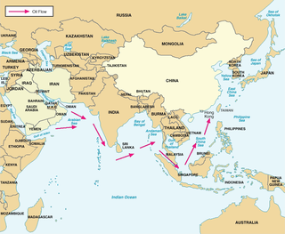
The String of Pearls is a geopolitical hypothesis proposed by United States political researchers in 2004. The term refers to the network of Chinese military and commercial facilities and relationships along its sea lines of communication, which extend from the Chinese mainland to Port Sudan in the Horn of Africa. The sea lines run through several major maritime choke points such as the Strait of Mandeb, the Strait of Malacca, the Strait of Hormuz, and the Lombok Strait as well as other strategic maritime centres in Somalia and the littoral South Asian countries of Pakistan, Sri Lanka, Bangladesh, and the Maldives.

Piracy in Indonesia is not only notorious, but according to a survey conducted by the International Maritime Bureau, it was also the country sporting the highest rate of pirate attacks back in 2004, where it subsequently dropped to second place of the world's worst country of pirate attacks in 2008, finishing just behind Nigeria. However, Indonesia is still deemed the country with the world's most dangerous water due to its high piracy rate. With more than half of the world's piracy crimes surrounding the South-East Asia aquatic regions, the turmoil caused by piracy has made the Strait of Malacca a distinct pirate hotspot accounting for most of the attacks in Indonesia, making the ships that sail in this region risky ever since the Europeans arrived. The term 'Piracy in Indonesia' includes both cases of Indonesian pirates hijacking other cargo and tanks, as well as the high rate of practising piracy within the country itself. The Strait of Malacca is also one of the world's busiest shipping routes as it accounts for more than twenty-five percent of the world's barter goods that come mainly from China and Japan. Approximately 50,000 vessels worth of the world's trade employ the strait annually, including oil from the Persian Gulf and manufactured goods to the Middle East and Suez Canal. The success that stems from this trade portal makes the Strait an ideal location for pirate attacks.

The Central Spine Road 2 or Malacca Strait Bridge is a proposed bridge that would connect Telok Gong, near Masjid Tanah, Malacca in Peninsular Malaysia to Rupat Island and Dumai in Sumatra island, Indonesia. The project has been submitted for government approval, and is expected to take 10 years to complete. Once completed, the 48-kilometre-long (30 mi) bridge will be the longest sea-crossing bridge in the world. The project will have two cable-stayed bridges and one suspension bridge, both the longest in the world.

<span class="mw-page-title-main">Istanbul Canal</span> Artificial sea-level waterway project

The Istanbul Canal is a project for an artificial sea-level waterway planned by Turkey in East Thrace, connecting the Black Sea to the Sea of Marmara, and thus to the Aegean and Mediterranean seas. Istanbul Canal would bisect the current European side of Istanbul and thus form an island between Asia and Europe. The new waterway would bypass the current Bosporus.

<span class="mw-page-title-main">21st Century Maritime Silk Road</span> Sea route part

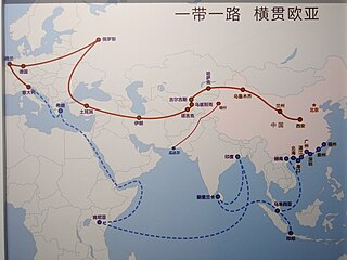
The 21st Century Maritime Silk Road, commonly just Maritime Silk Road (MSR), is the sea route part of the Belt and Road Initiative which is a Chinese strategic initiative to increase investment and foster collaboration across the historic Silk Road.

References

  1. Noorul Shaiful Fitri Abdul Rahman; Nurul Haqimin Mohd Salleh; Ahmad Fayas Ahmad Najib; Lun, Venus Y (21 November 2016). "A descriptive method for analysing the Kra Canal decision on maritime business patterns in Malaysia". Journal of Shipping and Trade. 61 (13). doi: 10.1186/s41072-016-0016-0 .
  2. 1 2 3 4 "Time to revisit canal project" (Opinion). Bangkok Post. 20 January 2020. Retrieved 20 January 2020.
  3. "Proposed Kra Canal not priority project for Thai govt". The Straits Times. 13 February 2018. Retrieved 13 February 2018.
  4. "History: Ayutthaya Period". The Kra Canal: New Gateway to Maritime Silk Road. Thai Chinese Cultural & Economic Association. Archived from the original on 21 May 2015. Retrieved 19 May 2015.
  5. Fine, Herbert A. (1965). "The Liquidation of World War II in Thailand". Pacific Historical Review. 34 (1): 65–82. doi:10.2307/3636740. JSTOR   3636740.
  6. Tarling, Nicholas (1978). "Rice and Reconciliation: The Anglo-Thai Peace Negotiations of 1945" (PDF). Journal of the Siam Society. 66 (2): 59–112.
  7. "Untitled". Archived from the original on 17 March 2009. Retrieved 19 August 2009.
  8. "Untitled". Archived from the original on 17 March 2009. Retrieved 19 August 2009.
  9. Chongkittavorn, Kavi (28 January 2020). "Is digging Kra Canal still a pipe dream?" (Opinion). Bangkok Post. Retrieved 28 January 2020.
  10. Voytenko, Mikhail (18 February 2018). "Thailand Merchant Marine can play a bigger role". Maritime Bulletin. Retrieved 20 February 2018.
  11. Wongcha-um, Panu (19 May 2015). "Thailand denies Kra Canal deal". Channel NewsAsia. Retrieved 19 May 2015.
  12. 1 2 Parpart, Erich (16 October 2017). "Can You Dig It?". Bangkok Post. Retrieved 17 October 2017.
  13. "Thailand's Kra Canal: Game-Changer Waiting to Happen". Oceaneering. Retrieved 20 October 2017.
  14. Chongkittavorn, Kavi (30 March 2015). "Thailand ponders digging Kra Isthmus - again!". The Nation. Retrieved 30 March 2015.
  15. "Thailand, China to team up on long-proposed Kra Isthmus canal". Want China Times. 18 May 2015. Archived from the original on 5 July 2015. Retrieved 18 May 2015.
  16. "China announces strategically important Kra Isthmus Canal in Thailand". China Daily Mail. 17 May 2015. Retrieved 18 May 2015.
  17. "China calling: 'String of pearls'". Pittsburgh Tribune-Review. 25 February 2005. Archived from the original on 23 February 2006. Retrieved 1 November 2007.
  18. Chaudhury, Dipanjan Roy (23 August 2007). "Boosting Maritime Capabilities in the Indian Ocean". Worldpress. Retrieved 1 November 2007.
  19. "Economists agree over Kra Canal". The Nation . Bangkok. 7 July 1998. Archived from the original on 5 July 2015. Retrieved 29 May 2015 via HighBeam Research.
  20. Suryati Sulong, Rini (2012). "The Kra Canal and Southeast Asian Relations". Journal of Current Southeast Asian Affairs. 31 (4).
  21. "Home". The Kra Canal: New Gateway to Maritime Silk Road. Thai Chinese Cultural & Economic Association. Archived from the original on 21 May 2015. Retrieved 19 May 2015.
  22. "KL has no qualms over proposed canal". Business Times. 7 May 2002. Archived from the original on 5 July 2015. Retrieved 27 May 2015 via HighBeam Research.
  23. The Thai canal may change Singapore forever, Cheong Suk-Wai, The Straits Times, 30 April 2016, retrieved 20 January 2017
  24. "Thailand's Kra Canal: Game-Changer Waiting to Happen". PortVision. Oceaneering. 20 September 2017. Retrieved 21 September 2017.
  25. Strait of Malacca - World Oil Transit Chokepoints, Energy Information Administration, U.S. Department of Energy Archived 22 November 2014 at the Wayback Machine
  26. Characteristics and Changes in Freight Transportation Demand: Appendix F. - Estimating Transport Costs p. F-18. Cambridge Systematic, Inc.
  27. What will Thailand benefit from the Thai Canal project? Article by Assoc. Prof. Dr. Satapon Keovimol
  28. "How much, for what, and ending up where?". United Nations Environment Programme Global Marine Oil Pollution Information Gateway.
  29. "The Next Front in the India-China Conflict Could Be a Thai Canal". Foreign Policy . 1 September 2020.
  30. Lindsay Hughes (21 May 2019). "String of Pearls Redux: China, India and a Cambodian Base". Future Directions International. Retrieved 23 February 2021.
  31. Praveen Swami (6 April 2018). "Fears rise in India as China pushes plan for canal to reshape Indian Ocean". Business Standard India. Business Standard . Retrieved 23 February 2021.

General references

10°11′N98°53′E / 10.183°N 98.883°E / 10.183; 98.883