The Grange and Macquarie Plains Cemetery

Last updated

The Grange and Macquarie Plains Cemetery
1904 - The Grange and Macquarie Plains Cemetery - North facade of Grange farmhouse facing courtyard with cottage on left (east) and kitchen wing on right (west). (5060570b3).jpg
North facade of Grange farmhouse facing courtyard with cottage on left (east) and kitchen wing on right (west)
Location3249 O'Connell Road, Bathurst, Bathurst Region, New South Wales, Australia
Coordinates 33°29′46″S149°40′46″E / 33.4962°S 149.6794°E / -33.4962; 149.6794
Built1830–1836
ArchitectVernacular
Official nameThe Grange and Macquarie Plains Cemetery; Macquarie Plains Cemetery
Typestate heritage (complex / group)
Designated15 March 2013
Reference no.1904
TypeHomestead Complex
CategoryFarming and Grazing
BuildersVernacular – probably convict labour
Australia New South Wales relief location map.png
Red pog.svg
Location of The Grange and Macquarie Plains Cemetery in New South Wales

The Grange and Macquarie Plains Cemetery are a heritage-listed homestead and cemetery at 3249 O'Connell Road, Bathurst, Bathurst Region, New South Wales, Australia. It was built from 1830 to 1836, probably by convict labour. It was added to the New South Wales State Heritage Register on 15 March 2013. [1]

Contents

History

Aboriginal land

Aboriginal occupation of the Blue Mountains area dates back at least 12,000 years and appears to have intensified some 3000–4000 years ago. In pre-colonial times the area now known as Bathurst was inhabited by Aboriginal people of the Wiradjuri group. The clan associated with Bathurst occupied on a seasonal basis most of the Macquarie River area. They moved regularly in small groups but preferred the open land and used the waterways for a variety of food. There are numerous river flats where debris from recurrent camps accumulated over a long period. Colonisation in this region after the first documented European expedition west of the Blue Mountains in 1813 was tentative because of resistance from Aboriginal people. There was some contact, witnessed by sporadic hostility and by the quantity of surviving artefacts manufactured by the Aborigines from European glass. By 1840 there was widespread dislocation of Aboriginal culture, aggravated after 1850 by the gold rush to the region. [2] [1]

Colonisation

European exploration of the Bathurst area is an extension of the exploration of the eastern inland following closely upon the crossing of the Blue Mountains in 1813. Assistant Surveyor George Evans undertook an initial reconnaissance as far as the Bathurst Plains also in 1813. Bathurst then served as the commencement point for many later official expeditions, as well as for many unofficial reconnaissances by settlers and soldiers. [3] [1]

In 1814–1815, the first road across the Blue Mountains and on to Bathurst was constructed by William Cox and convict labourers. Known as Cox's Road, it reached O'Connell Plains, much of it along the same route as present-day Carlwood Road. Keeping to the south of the Fish River, it passed by the current location of the Grange about a kilometre to its south. [1]

Within a decade or so of its construction, Cox's Road was rivalled as the preferred route from the mountains by other roads, including unofficial deviations which offered either easier or shorter routes. Locally, these changes were mainly to do with crossing the river to the east of Bathurst and approaching the settled area over more easily travelled country. The new routes also reflected new land grants in and around Kelso. A new official route was surveyed in 1823 which crossed the Fish River at O'Connell and, following the line of a similar route to the present day Bathurst-O'Connell Road, entered Bathurst via Kelso, thus requiring a crossing of the Macquarie River at the Bathurst settlement. The current Bathurst-O'Connell Road has bisected the Grange property since 1860. [4] [1]

With the extension of British colonial rule beyond the Blue Mountains in 1815, the system of land tenure established in Sydney was extended into the Bathurst region. This system did not recognise prior Aboriginal ownership of the land but understood all land to be owned by the Crown, to be provided to settlers through land grants. Governor Macquarie, who favoured a limited settlement of the newly discovered country west of the Blue Mountains, strictly controlled the alienation of Crown Land in the Bathurst area during his governorship between 1810 and 1821. Land grants were made during Macquarie's administration to only a handful of pastoralists. This included generous land grants to those associated with the opening of the way to the interior and the building of the roads to Bathurst, notably William Cox and William Lawson. Much smaller land grants were also made in 1818 to ten less prominent settlers, a mix of free and emancipist men, for farms in the Kelso area. [1]

The Grange

Soon after this in 1821, land grants on adjacent lots were also made by Governor Macquarie to free settler brothers, Thomas and John West. Each was granted 600 acres of land, and John West established The Grange, while Thomas West established Westham to the east. Both West brothers built similar styled Georgian farm houses, and both farmhouses are still extant, although the Grange is possibly more intact than Westham. [1]

In 1822 Governor Brisbane introduced a more expansionary policy of land grants. Free settlers were encouraged to apply for land grants and allowed to nominate specific blocks of land. Brisbane's encouragement of pastoral settlement, with the consequent in-rush of grant holders and their stock, quickly overran huge tracks of Wiradjuri land. In 1824 the Wiradjuri attempted an armed resistance to this threat, led by Windradyne, which was ruthlessly put down by the troops in Bathurst. [1]

The success of some of the early pastoralists led to the building of quite substantial homesteads soon after their arrival. The remaining fabric of these homesteads often display the evolution of the pastoralists' success – with rooms and wings added to the basic, original building and open areas enclosed. A number of these early homesteads such as The Grange and Westham still exist, usually single storey and sometimes Georgian in style but adapted for the colonial climate. Their style, size and substance reflected the growing wealth and status of the owners, men who had been able to gain the best land on the plains. The Grange is a particularly good surviving example of a Georgian homestead, as it is largely unaltered from its original construction. These early homesteads provided accommodation not only for the pastoralist and his family but also for servants and workers, including assigned convicts prior to the 1840s. Outbuildings used today for other purposes may have once provided accommodations for servants and farm workers. [5] [1]

Farmhouse, circa 1900 1904 - The Grange and Macquarie Plains Cemetery - Historic photo fo the farmhouse building at the Grange, dating from c1900, held by Edward Jones (5060570b27).jpg
Farmhouse, circa 1900

The original farmhouse was constructed by John West c.1830 (most likely using convict labour assigned to him) of brick walls, timber shingles roof and surrounding verandah. It is believed to have been named The Grange at this time by John West. A similar shaped farmhouse is built around the same time by his brother Thomas West on his adjoining land grant, named Westham. [1]

The Cottage, built c. 1836 1904 - The Grange and Macquarie Plains Cemetery - The Cottage, dating from c.1836 on the north east side of the Grange farmhouse (5060570b10).jpg
The Cottage, built c.1836

A brick cottage adjacent to the original The Grange farmhouse was built in 1836. [1]

In 1860 a new road to O'Connell was built, bisecting the property. [1]

In 1920, the original 600-acre land grant was divided into three 250-acre lots. The lot containing The Grange farmhouse was retained by the West family, while the remaining two lots were sold and became known as Illawong and Westbrook (now known as Ashbrook). [1]

The Grange was used for pastoral farming by four generations of the West family until it was sold to Edward Rooke in 1955. In 1965 the Grange was sold to Dr Brooke Moore and Mrs Freeda Moore, and then in 1972 was sold to Mrs Moore's niece and her husband, the current owners in 2012, Edward and Lorraine Jones. The buildings were in poor condition in the 1970s and have been gradually conserved since then by the current owners. [1]

Timeline of the Grange residents

Macquarie Plains Cemetery

Around 1844 John West donated two-thirds of an acre (quarter of a hectare) of land to the Methodist Church to build a small church and cemetery. The cemetery appears to have been first used in 1837 and discontinued in 1896. The first known burial had been Eliza Hall in 1837. It contains at least 22 graves. The timber church was demolished in 1920. The land with cemetery was purchased back from the Uniting Church of Australia in 1997 by Edward and Lorraine Jones. [1]

Description

The Grange is located 12 km southeast of Bathurst within the Macquarie Valley in the Central Tablelands district. The 28 hectares included in this listing is that part of Lot 6 DP 880125 located between O'Connell Road and the Fish River as well as the adjacent quarter hectare lot with cemetery dating from the mid-nineteenth century. Both are a remnant of the original grant of 600 acres (243 hectares) made to John West by Lachlan Macquarie c. 1821. [1]

Grounds and gardens

The gardens around the homestead do not appear to be original and may not be heritage significant. They have been largely planted by the current owners since purchasing the property in 1972. It is believed the gum tree at the entrance gate to the property on O'Connell Road is more historic and is considered significant. There is also an historic poplar tree located on the western side of the kitchen wing. No heritage survey of the vegetation on the property had been conducted by the time of the SHR listing in 2012. [1]

The remainder of the original grant land surrounding the homestead to be included in the SHR listing has been used traditionally for pasturing sheep and includes vernacular structures such as corrugated iron and timber sheds, fencing and sheep yards. There is a non-significant green house on the east side of the homestead. No heritage survey of these ancillary structures on the property had been conducted by the time of the SHR listing in 2012. [1]

Cemetery

View of the cemetery, facing south from O'Connell Road and looking towards the river 1904 - The Grange and Macquarie Plains Cemetery - View of the cemetery at the Grange, facing south from O'Connell Road and looking towards the river (5060570b22).jpg
View of the cemetery, facing south from O'Connell Road and looking towards the river

The cemetery is located on a 2/3 acre parcel of land donated by John West to the Methodist Church in 1844 and retains its separate Land Parcel number. [9] It is located 500m to the south of The Grange farmhouse and sits in the north eastern corner of the section of land south of O'Connell Road. It is bordered to the south and east by the Grange, by O'Connell Road to the north, and the neighbouring property [10] to the west. A small wooden Methodist church was apparently demolished c. 1920 and only the ruins of the graveyard remain. The graves are those of local Macquarie Plains families, including some members of the West family, apparently dating from between 1837 and 1896. 22 inscriptions were recorded for the Australian Cemeteries Index in 2006 and are available for viewing online. This website quotes a local community member stating that the cemetery was a children's cemetery during the 1876 scarlet fever epidemic, and that many children are buried here in unmarked graves. [1]

Homestead

Farmhouse's hallway 1904 - The Grange and Macquarie Plains Cemetery - Interior photo of the Grannge farmhouse's hallway (5060570b9).jpg
Farmhouse's hallway

The homestead includes a Georgian farmhouse understood to date from c. 1830, a kitchen-garage wing on the north eastern side, probably dating from the same time and a cottage wing on the north western side dating from c. 1836. Both wings are now joined to the original house to form a courtyard entrance area facing O'Connell Road. [1]

The original farmhouse has a verandah which originally surrounded the house entirely and is believed to be one of earliest examples of a wrap-around verandah built in Australia. [11] The verandah has been enclosed on two northern corners to form rooms that now connect the farmhouse to the cottage and the kitchen-garage wing. An "outdoor" room has also been added c. 1980 near the southwest corner of the farmhouse. The verandah has a separated roof with a lower pitch than the main roof, a solution favoured aesthectially from the mid-1830s. [12] The walls of the farmhouse are rendered brickwork. A partition wall within the kitchen wing is constructed of pise. The original windows on the farmhouse are timber-framed, double-hung with six lights per pane, fine glazing bars and mostly original glass. The original entrance (facing south towards the river) has a formal symmetrical facade with a central door and half round fan-light with 8 panels. The original shingles for the roof, manufactured locally, are believed to be still in place beneath the corrugated iron roof. The most intact part of the original farmhouse is its hallway. [1]

John West had several male convicts listed under his household during the period the three sections of the homestead were constructed, so it is believed to be convict built. [1]

The homestead was originally designed with the front entrance facing the original road to the south. The construction of a new road to the north c. 1860 (O'Connell Road) necessitated a changed orientation for the house to the north, utilising what was originally the rear facade and courtyard, which now acts as the entrance to the homestead. [1]

Kitchen

Kitchen 1904 - The Grange and Macquarie Plains Cemetery - Interior photo of kitchen at the Grange (5060570b17).jpg
Kitchen

The kitchen, originally built as a separate outhouse and probably dating from the same time as the original farmhouse. The cottage dating from c. 1836 was built using hand-produced bricks. [13] [1]

Condition

As at 29 August 2012, The Grange farmhouse (c. 1830) remains largely on its original footprint and retains a considerable proportion of its original construction although with extensive minor changes to the configuration of internal rooms, and rooms added to three of the four corners of the wrap around verandah. There is rising damp in bedrooms on the north east side. [1]

The cottage (c. 1836) retains its external walls but has been extended one room's width to the east to incorporate a new kitchen and bathroom. What was previously a tack room (used to house equipment for horses when bought by the current owners in 1972) has been turned into a sitting room but the bedrooms on the south west end of the cottage remain in their original configuration. [1]

The cemetery is in derelict and unrenovated condition. The Australian Cemeteries Index describes it: "Several of the stones have been repaired or re-erected after falling or being knocked over at some stage. Two of the sandstone monuments have been eroded by rising salt near ground level rendering the lower text unreadable but others are in surprisingly good condition for their age." 22 inscriptions transcribed by the index in 2006 and updated in 2012 are available online. Records concerning the cemetery are apparently also available from the National Trust and Bathurst Council. [1]

Modifications and dates

The Grange has been altered over time by its various occupants. The construction of the new O'Connell Road c. 1860 (which bisected the original land grant property) brought about a change in entry from the southwestern facade, facing the river to the northeastern facade facing O'Connell Road. [1]

In c. 1880 the wall dividing the sitting and dining rooms was demolished to form one larger living room. The fireplace was relocated to the western wall of the room, using the original cedar mantle (Edwards CMP). [1]

The fireplace in the main bedroom is believed to have been added or renovated in 1880 at the same time as the living room fireplace, using the same bricks. The ceiling in this room is thought to have been replaced c. 1920. The ceiling in the second bedroom is also thought to have been replaced at this time. [1]

A bathroom was created in the lobby and part of the verandah, c. 1920s. [1]

The once separate kitchen wing was joined to the main house prior to 1900. A fibro panelled ceiling in the kitchen was installed c. 1920. [1]

In 1965 the wood room was repaired for wood storage. In 1975 a door was attached to the wood room for security. [1]

The timber floor of the kitchen was replaced with cement in 1965. [1]

In 1972 the original sulky shed collapsed (now the garage area consisting of two open garages and a tool room with the kitchen roofline extended for symmetry). [1]

In 1975 access was made to the small outside verandah bedroom. [1]

In 1975 the corners of the rear verandah were enclosed to form a dressing room and bathroom. The kitchen was renovated in 1975, removing the wood fired stove. The doors from the kitchen out to the kitchen garden were replaced in 1975. In 1975 a door was added from the dining room through to the wood room. [1]

In 1980 an outdoor room was added near the south western corner of the house. [1]

The original ceiling in the dining room (small corner room) was replaced in 1985. The original horsehair and plaster ceiling of the small bedroom collapsed and was replaced in 1985. [1]

In 1998 the lobby/bathroom window was replaced with French doors. [1]

The cottage earlier consisted of two bedrooms joined by a doorway with two entries to the courtyard. The cottage was partially rebuilt in 1973 and one doorway to the courtyard removed. The smaller of the two rooms, then a tack room, became a living area with a concrete floor to replace the dirt floor. The larger room had a fireplace and two windows and was partitioned off to form two bedrooms. A new brick extension was added to the western side of the cottage, consisting of a kitchen/dining, a lobby and a bathroom. The bricks used for the new extension were sourced from the demolition of the National Bank in Bathurst. [1]

Heritage listing

Heritage boundaries 1904 - The Grange and Macquarie Plains Cemetery - SHR Plan 2555 (5060570b100).jpg
Heritage boundaries

The Grange is of state significance for its history and rarity as one of the earliest surviving colonial farmhouses built in inland Australia. Forming one of the pioneering families of the Bathurst region, John West and his brother Thomas came to the area in 1821 to farm on adjoining lands granted to them by Governor Macquarie. John West's farmhouse dating from 1830 has aesthetic significance for its wrap-around verandah, which has been claimed to be the earliest surviving example of its kind in Australia, and for its well-proportioned and symmetrical Georgian facade. The Grange also has significance for its potential to provide insights into early colonial life and conditions for convicts, some of whom were known to have been assigned to the farm. The historic Methodist cemetery (used c. 1855–1896), on quarter hectare of the original grant, is an important relic from the time of the early settler families in the area, and includes the graves of members of the West family. [1]

The Grange and Macquarie Plains Cemetery was listed on the New South Wales State Heritage Register on 15 March 2013 having satisfied the following criteria. [1]

The place is important in demonstrating the course, or pattern, of cultural or natural history in New South Wales.

The Grange is of state significance as one of the earliest residences to be constructed in inland Australia and an early example of a colonial Georgian house. It was probably built by convict labour around 1830 on land granted to John West in 1821, one of only a few land grants made in the area by Governor Macquarie. John West, a free settler farmer who may have participated in the original surveying of the area, along with his brother Thomas, were early landowners and a founding family of the district. The historic cemetery is a relic from the time of the early days of colonisation in the area, and includes the graves of members of the West family. The Grange is a prominent property in and important historical locale for the development of the region of Bathurst. The listing includes 27 hectares of land from the original 1821 grant. [1]

The place has a strong or special association with a person, or group of persons, of importance of cultural or natural history of New South Wales's history.

The Grange is of local significance for its association with the governorship of Lachlan Macquarie, being one of the few land grants made by Macquarie west of the Blue Mountains. It is also of local significance for its geographical association with the building of the early roads to Bathurst, since it was established within a few years and within a few kilometres of Cox's pioneering road to Bathurst. It is also of local significance for its association with the pioneering West family in Bathurst, being originally owned and built by John West and located adjoining property owned by his brother Thomas West. [1]

The place is important in demonstrating aesthetic characteristics and/or a high degree of creative or technical achievement in New South Wales.

The Grange is of state significance aesthetically as an exemplar of a colonial farmhouse which demonstrates the symmetrical and well-proportioned characteristics of the Georgian architectural style. Its wrap-around verandah, dating from c. 1830, has been described as the first to be built in Australia. [1]

The place has a strong or special association with a particular community or cultural group in New South Wales for social, cultural or spiritual reasons.

The Grange is of local significance to many people in the Bathurst area as an intact demonstration of colonial life in the Bathurst region at the commencement of European settlement in the area. [1]

The place has potential to yield information that will contribute to an understanding of the cultural or natural history of New South Wales.

The Grange is of at least local significance as for its potential to yield archaeological information about the colonial and convict history of NSW and the lives and occupations of the people who worked there. [1]

The place possesses uncommon, rare or endangered aspects of the cultural or natural history of New South Wales.

The Grange is of state significance for its rarity as a fairly intact example of an early Georgian colonial farmhouse. The cemetery at The Grange is of local significance as a rare surviving example of a community burial site for early settlers and their families. [1]

The place is important in demonstrating the principal characteristics of a class of cultural or natural places/environments in New South Wales.

The Grange is of state significance as a representative example of a colonial Georgian homestead probably built by convict labour on an early colonial land grant. [1]

Related Research Articles

<span class="mw-page-title-main">Miss Traill's House</span> Historic house in Bathurst, New South Wales, Australia

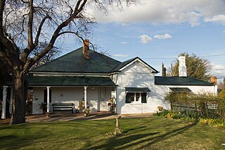
Miss Traill's House is a heritage-listed former residence, clergy house and school and now museum at 321 Russell Street, Bathurst, Bathurst Region, New South Wales, Australia. It was designed by Henry Kitchen and built from 1845 by Reverend Thomas Sharpe. It is also known as All Saints Rectory, Entelly and Wyoming Lodge. The property is owned by the National Trust of Australia (NSW). It was added to the New South Wales State Heritage Register on 1 March, 2002.

<span class="mw-page-title-main">Mountain View Homestead and General Store</span> Historic site in New South Wales, Australia

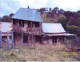
Mountain View Homestead and General Store is a heritage-listed homestead and general store at Wisemans Creek, Oberon Shire, New South Wales, Australia. It was designed by David Smith Todd, who built the homestead from 1880 to 1894. It was added to the New South Wales State Heritage Register on 10 March 2006.

<span class="mw-page-title-main">Holy Trinity Anglican Church, Kelso</span> Heritage listed Church in New South Wales, Australia

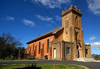
Holy Trinity Anglican Church is a heritage-listed Anglican church precinct, containing the church, rectory and adjacent cemetery, at 71-85 Gilmour Street, Kelso, Bathurst Region, New South Wales, Australia. The church was built from 1833 to 1878, with John Foster being responsible for the building of the original church. Edmund Blacket designed the rectory. The property is owned by Anglican Property Trust Diocese of Bathurst and Parish of Kelso, Anglican Diocese of Bathurst. It was added to the New South Wales State Heritage Register on 14 January 2011.

<span class="mw-page-title-main">Llanarth (house)</span> Heritage listed house in New South Wales, Australia

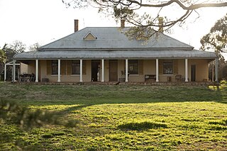
Llanarth is a heritage-listed residence at 120 Eglinton Road, Llanarth, Bathurst Region, New South Wales, Australia. It was built from 1858 to 1864, the original house by W. Atkins and the 1864 alterations by John Smith. The 1907 stables were designed by J. J. Copeman. It is also known as Strathden and Stratheden. It was added to the New South Wales State Heritage Register on 2 April 1999.

<span class="mw-page-title-main">Old Government Cottages Group, Bathurst</span> Historic site in New South Wales, Australia

The Old Government Cottages Group consists of two heritage-listed houses at 16 Stanley Street and 1 George Street, Bathurst, Bathurst Region, New South Wales, Australia. The group was built from 1837 to 1860. The buildings are also known as 'Old Government House', Macquarie House, Miss Falloon's cottage and John Ford's house. The property is owned by Bathurst Regional Council. It was added to the New South Wales State Heritage Register on 21 February 2003.

<span class="mw-page-title-main">Merembra Homestead</span> Historic site in New South Wales, Australia

Merembra Homestead is a heritage-listed homestead and former inn at 218 Gormans Hill Road, Bathurst, Bathurst Region, New South Wales, Australia. It was built from 1863 to 1864. It was also known as John's Farm and Barley Mow Inn. It was added to the New South Wales State Heritage Register on 14 July 2000.

<span class="mw-page-title-main">Royal Hotel, Bathurst</span> Historic site in New South Wales, Australia

The Royal Hotel is a heritage-listed former hotel and now commercial and apartment building located at 108 William Street, Bathurst, Bathurst Region, New South Wales, Australia. The property is privately owned. It was added to the New South Wales State Heritage Register on 2 April 1999.

<span class="mw-page-title-main">Clydesdale, Marsden Park</span> Historic site in New South Wales, Australia

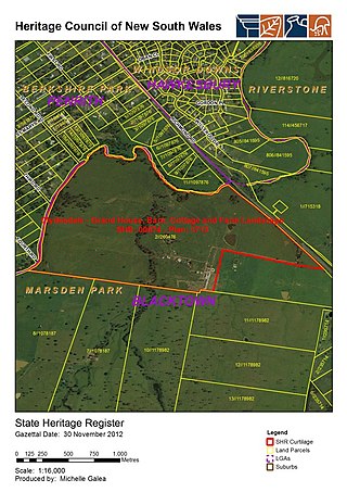
Clydesdale is a heritage-listed homestead and former seminary and missionary school (1859–71) and wartime hospital (1942–44) at 1270 Richmond Road, Marsden Park, City of Blacktown, New South Wales, Australia. It was built from 1823 to 1885. It is also known as Lang's Farm; the northern half is also known as Echovale. It was added to the New South Wales State Heritage Register on 2 April 1999.

<span class="mw-page-title-main">Bungarribee Homestead Site</span> Historic site in New South Wales, Australia

The Bungarribee Homestead Site is a heritage-listed archaeological site at the location of the former Bungarribee Homestead. The site is located at Doonside Road, Doonside, City of Blacktown, Sydney New South Wales, Australia. It was added to the New South Wales State Heritage Register on 8 December 2000.

Arnprior is a heritage-listed homestead and farm at Mayfield Road, Larbert, Queanbeyan-Palerang Region, New South Wales, Australia. It was built from 1827 by William Ryrie. It was added to the New South Wales State Heritage Register on 18 November 1999.

<span class="mw-page-title-main">Englefield, East Maitland</span> Historic site in New South Wales, Australia

Englefield is a heritage-listed former inn and now residence at 49 Newcastle Street, East Maitland, City of Maitland, New South Wales, Australia. It was built in 1837. It operated as the Black Horse Inn from 1845 to 1878. It was added to the New South Wales State Heritage Register on 30 April 2008.

<i>Macquarie Grove</i> Historic site in New South Wales, Australia

Macquarie Grove is a heritage-listed former airport administration offices and private residence and now private residence located at Aerodrome Road, Cobbitty, in the south-western Sydney suburb of Camden in the Camden Council local government area of New South Wales, Australia. It was built from 1812 to 1850. The property is privately owned. It was added to the New South Wales State Heritage Register on 2 April 1999.

<i>Harrington Park</i> (homestead) Historic site in New South Wales, Australia

Harrington Park is a heritage-listed former race track, rural estate management and alluvial grazing paddocks located at 1 Hickson Circuit in the south-western Sydney suburb of Harrington Park in the Camden Council local government area of New South Wales, Australia. The original designer is unconfirmed, with 1950-60s additions completed by Marcel Weyland. The homestead was built from 1817 to 1827. The property is privately owned and was added to the New South Wales State Heritage Register on 22 December 2006.

<span class="mw-page-title-main">Mountain View, Richmond</span> Historic site in New South Wales, Australia

Mountain View is a heritage-listed residence at 22 Inalls Lane, Richmond, City of Hawkesbury, New South Wales, Australia. It was built from 1804 to 1870 by Lewis Jones and James Vincent. It is also known as Dight's Farm. It was added to the New South Wales State Heritage Register on 2 April 1999.

<span class="mw-page-title-main">Macquarie Arms Inn</span> Historic site in New South Wales, Australia

Macquarie Arms Inn is a heritage-listed former inn and now residence at 104-106 Bathurst Street, Pitt Town, City of Hawkesbury, New South Wales, Australia. It was also known as the Blighton Arms and Flemings Public House in its time as an inn, while the main house on the property became known as Mulgrave Place. It was added to the New South Wales State Heritage Register on 2 April 1999.

<span class="mw-page-title-main">Sugarloaf Farm</span> Historic site in New South Wales, Australia

Sugarloaf Farm is a heritage-listed former dairy, wheat farming and pastoral property and now residence and horse riding venue located at Menangle Road, Gilead, City of Campbelltown, New South Wales, Australia. It was designed and built from 1835. It is also known as Mt Huon. The property is owned by the New South Wales Department of Planning and Infrastructure. It was added to the New South Wales State Heritage Register on 2 April 1999.

<i>Denfield</i> Historic site in New South Wales, Australia

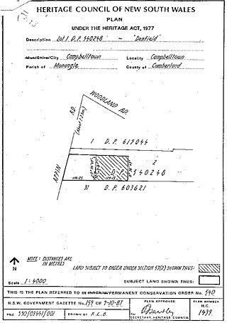
Denfield is a heritage-listed former farm homestead complex, residence, inn and farm and now residence located at Appin Road, St Helens Park in the City of Campbelltown local government area of New South Wales, Australia. It was built in 1837 by John Farley. It was added to the New South Wales State Heritage Register on 2 April 1999.

Cox's Cottage is a heritage-listed pasturing land and residence located at 2 St Thomas Road in the western Sydney suburb of Mulgoa in the City of Penrith local government area of New South Wales, Australia. It was built from 1810 to 1811 by James King. It is also known as Mulgoa Cottage; The Cottage, Coxs Cottage, and was formally known as Fern Hill and Estate of Mulgoa before the new house was built. The property remains privately owned and is the oldest house in Australia still in residence. It was added to the New South Wales State Heritage Register on 2 April 1999.

Wambo Homestead is a heritage-listed disused homestead at Warkworth, Singleton Council, New South Wales, Australia. It was built from 1830 to 1906. It was added to the New South Wales State Heritage Register on 2 April 1999.

Lindlegreen Barn is a heritage-listed former Aboriginal land, farm and barn and now shed at 2509 O'Connell Road, O'Connell, Oberon Shire, New South Wales, Australia. It was designed by Thomas Hassall and built during 1827 by John Barker. It is also known as The Lindlegreen Barn and Hassall Barn. It was added to the New South Wales State Heritage Register on 24 August 2018.

References

  1. 1 2 3 4 5 6 7 8 9 10 11 12 13 14 15 16 17 18 19 20 21 22 23 24 25 26 27 28 29 30 31 32 33 34 35 36 37 38 39 40 41 42 43 44 45 46 47 48 49 50 51 "The Grange and Macquarie Plains Cemetery". New South Wales State Heritage Register . Department of Planning & Environment. H01904. Retrieved 2 June 2018. CC BY icon.svg Text is licensed by State of New South Wales (Department of Planning and Environment) under CC-BY 4.0 licence .
  2. HO & DUAP, 1996, 88
  3. McLachlan 2007, p. 40
  4. McLachlan 2007, p. 83
  5. McLachlan 2007, p. 96
  6. 1 2 West, 2013
  7. NSWSR 3266; 9/2652 pp. 67, 71
  8. Aust Death Index V1849338 105
  9. Lot 1, DP779403
  10. DP 10909350
  11. CMP 2007
  12. Broadbent 1997, p. 314
  13. CMP, 2007

Bibliography

Attribution

CC BY icon-80x15.png This Wikipedia article was originally based on The Grange and Macquarie Plains Cemetery , entry number 01904 in the New South Wales State Heritage Register published by the State of New South Wales (Department of Planning and Environment) 2018 under CC-BY 4.0 licence , accessed on 2 June 2018.