Threemile Run (Tohickon Creek)

Last updated
Threemile Run
USA Pennsylvania location map.svg
Red pog.svg
Threemile Run
Other name(s) Three Mile Run
Country United States
State Pennsylvania
County Bucks
Township West Rockhill, East Rockhill
Physical characteristics
Main source 500 feet (150 m)
40°22′19″N75°19′59″W / 40.37194°N 75.33306°W / 40.37194; -75.33306
River mouth 394 feet (120 m)
40°25′14″N75°16′1″W / 40.42056°N 75.26694°W / 40.42056; -75.26694 Coordinates: 40°25′14″N75°16′1″W / 40.42056°N 75.26694°W / 40.42056; -75.26694
Length 5.57 miles (8.96 km)
Basin features
Progression Threemile Run → Lake NockamixonTohickon CreekDelaware RiverDelaware Bay
River system Delaware River
Basin size 8.11 square miles (21.0 km2)
Waterbodies Lake Nockamixon
Bridges Forrest Road
Old Mill Road
South Bethlehem Pike (South West End Boulevard)
Hill Road
Stone Edge Road
North Rockhill Road
West Rock Road
Pennsylvania Route 313 (Doylestown Pike, Dublin Pike)

Threemile Run (Three Mile Run) is a tributary of the Tohickon Creek in Bucks County, Pennsylvania in the United States and is part of the Delaware River watershed.

Tributary stream or river that flows into a main stem river or lake

A tributary or affluent is a stream or river that flows into a larger stream or main stem river or a lake. A tributary does not flow directly into a sea or ocean. Tributaries and the main stem river drain the surrounding drainage basin of its surface water and groundwater, leading the water out into an ocean.

Tohickon Creek river in the United States of America

Tohickon Creek is a 29.5-mile-long (47.5 km) tributary of the Delaware River. Located entirely in Bucks County, in southeastern Pennsylvania, it rises in Springfield Township and has its confluence with the Delaware at Point Pleasant. It is dammed to form Lake Nockamixon.

Bucks County, Pennsylvania County in Pennsylvania, United States

Bucks County is a county located in the Commonwealth of Pennsylvania. As of the 2010 census, the population was 625,249, making it the fourth-most populous county in Pennsylvania and the 99th-most populous county in the United States. The county seat is Doylestown. The county is named after the English county of Buckinghamshire or more precisely, its shortname.

Contents

History

Threemile Run was named so long before it was so noted in John Scully's map of the Province of Pennsylvania in 1770. It flows in the first valley north of the East Branch Perkiomen Creek and powered several grist mills in its early days. [1]

East Branch Perkiomen Creek river in the United States of America

East Branch Perkiomen Creek is a 24.5-mile-long (39.4 km) tributary of Perkiomen Creek in southeast Pennsylvania in the United States.

Statistics

Threemile Run's GNIS identification number is 1189555, its Pennsylvania Department of Conservation and Natural Resources identification number is 03168. The stream drains 8.11 square miles (21.0 km2) and reaches its confluence at the Tohickon Creek's 17.60 river mile within the banks of Lake Nockamixon. [2] [3]

River mile

In the United States, a river mile is a measure of distance in miles along a river from its mouth. River mile numbers begin at zero and increase further upstream. The corresponding metric unit using kilometers is the river kilometer. They are analogous to vehicle roadway mile markers, except that river miles are rarely marked on the physical river; instead they are marked on navigation charts, and topographic maps. Riverfront properties are sometimes partially legally described by their river mile.

Lake Nockamixon lake of the United States of America

Lake Nockamixon is a reservoir in southeastern Pennsylvania, United States, and the largest lake in Bucks County. It is formed by a dam on Tohickon Creek and is the centerpiece of Nockamixon State Park. Swimming is not allowed in the lake, but boating is popular. The park maintains a marina and a boat rental as well as three other boat-launch areas.

Course

Threemile Run rises in West Rockhill Townhsip, Bucks County, Pennsylvania, from an unnamed pond at an elevation of 500 feet (150 m) next to Catch Basin Road and flows southeast, south, then southeast and meets a tributary from the right bank, then turns right to flow northeast. Threemile drained into the Tohickon Creek before the Tohickon was dammed in 1972 to form Lake Nockamixon. After the lake was formed, it drains into the lake about ¾ mile from the Tohickon at an elevation of 394 feet (120 m), resulting in an average slope of 19.03 feet per mile (3.35 meters per kilometer).

West Rockhill Township, Bucks County, Pennsylvania Township in Pennsylvania, United States

West Rockhill Township is a township in Bucks County, Pennsylvania, United States. The original Rockhill Township was established in 1740 and was divided into East Rockhill and West Rockhill Townships in 1890. The population was 5,256 at the 2010 census. West Rockhill Township is part of Pennridge School District.

Pennsylvania State of the United States of America

Pennsylvania, officially the Commonwealth of Pennsylvania, is a state located in the northeastern and Mid-Atlantic regions of the United States. The Appalachian Mountains run through its middle. The Commonwealth is bordered by Delaware to the southeast, Maryland to the south, West Virginia to the southwest, Ohio to the west, Lake Erie and the Canadian province of Ontario to the northwest, New York to the north, and New Jersey to the east.

Geology

Appalachian Mountains mountain range in the eastern United States and Canada

The Appalachian Mountains, often called the Appalachians, are a system of mountains in eastern North America. The Appalachians first formed roughly 480 million years ago during the Ordovician Period. They once reached elevations similar to those of the Alps and the Rocky Mountains before experiencing natural erosion. The Appalachian chain is a barrier to east–west travel, as it forms a series of alternating ridgelines and valleys oriented in opposition to most highways and railroads running east–west.

Piedmont (United States) plateau region located in the eastern United States

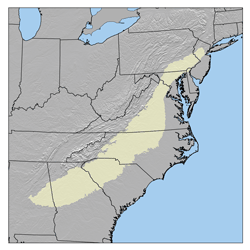
The Piedmont is a plateau region located in the Eastern United States. It sits between the Atlantic coastal plain and the main Appalachian Mountains, stretching from New Jersey in the north to central Alabama in the south. The Piedmont Province is a physiographic province of the larger Appalachian division which consists of the Gettysburg-Newark Lowlands, the Piedmont Upland and the Piedmont Lowlands sections.

Geology of Pennsylvania

The Geology of Pennsylvania consists of six distinct physiographic provinces, three of which are subdivided into different sections. Each province has its own economic advantages and geologic hazards and plays an important role in shaping everyday life in the state. They are: the Atlantic Coastal Plain Province, the Piedmont Province, the New England Province, the Ridge and Valley Province, the Appalachian Plateau Province, and the Central Lowlands Province.

The Brunswick Formation is a sedimentary layer of rock consisting of mudstone, siltstone, and beds of green, brown, and red-brown shale. Mineralogy consists of argillite and hornfels. About 200 million years ago, magma intruded into the Brunswick and cooled quickly forming a fine grained diabase consisting of primarily labradorite and augite. Haycock Mountain (on the right bank of the creek) and several other features in the area are remnants of the intrusion after the Brunswick has eroded away over time. The first mile or so of Threemile Run's course is located in a region of diabase rock which intruded into the local sedimentary layers of the Brunswick Formation during the Jurassic and the Triassic, then the remaining course flows over the Brunswick Formation. [4]

Crossings and Bridges

Crossing NBI Number Length Lanes Spans Material/Design Built Reconstructed LatitudeLongitude
Pennsylvania Route 313 (Doylestown Pike, Dublin Pike)699312.2 metres (40 ft)2Concrete Arch-Deck193040°24'5675°16'14"W
West Rock Road751624 metres (79 ft)21Prestressed concrete box beam or girders-multiple197940°24'7.1"N75°17'1.06"W
North Rockhill Road
Stone Edge Road
Hill Road751912|m|ft21Concrete Tee Beam193040°23'8"N75°18'27"W
South Old Bethlehem Pike (Park Avenue)75029 metres (30 ft)21Prestressed concrete box beam or girders - Multiple195540°22'57.3"N75°18'45"W
South Bethlehem Pike (South West End Boulevard)73856.7 metres (22 ft)Concrete Tee Beam, concrete cast-in-place deck, bituminous surface193640°22'50"N75°19'W
Old Mill Road (Township Road T360)75139 metres (30 ft)11Continuous concrete stringer/multi-beam or girder193040°22'46.9"N75°19'10.2"W
Forrest Road

Related Research Articles

Haycock Mountain mountain in United States of America

Haycock Mountain is a locally prominent hill with the highest summit in Bucks County. It rises above Nockamixon State Park, in the Delaware River drainage of southeastern Pennsylvania. Early settlers named it simply for its "resemblance to a cock of hay."

Cabin Run (Tohickon Creek, Delaware River) tributary of Tohickon Creek in Bucks County, Pennsylvania


Cabin Run is a tributary of the Tohickon Creek in Bucks County, Pennsylvania, rising in the southwestern portion of Bedminster Township to its confluence with the Tohickon Creek in northeastern Plumstead Township. Its course is approximately 4.5 miles (7.2 km)

Mill Creek (Neshaminy Creek tributary, Wrightstown Township)


Mill Creek is a tributary of Neshaminy Creek, one of three tributaries of the Neshaminy which all share the same name, and one of six in Bucks County, Pennsylvania which share the name. The Geographic Name Information System I.D. is 1181118, U.S. Department of the Interior Geological Survey I.D. is 02596.

Robin Run


Robin Run is a tributary of Mill Creek, rising in Buckingham Township, Bucks County, Pennsylvania flows generally southeast to its confluence with Mill Creek in Wrightstown Township. The Geographic Name Information System I.D. is 1185219, U.S. Department of the Interior Geological Survey I.D. is 02598.

Hickory Creek (Delaware River)


Hickory Creek is a tributary of the Delaware River in Plumstead Township, Bucks County, Pennsylvania, in the United States.

Geddes Run (Tohickon Creek)

Geddes Run is a tributary of the Tohickon Creek contained wholly within Plumstead Township, Bucks County, Pennsylvania, in the United States.

Deep Run (Tohickon Creek)


Deep Run is a tributary of Tohickon Creek in Bedminster Township, Bucks County, Pennsylvania, in the United States.

Wolf Run (Tohickon Creek)

Deep Run is a tributary of the Tohickon Creek in Bedminster Township, Bucks County, Pennsylvania in the United States.

Deer Run (Tohickon Creek)

Deer Run is a tributary of the Tohickon Creek in Bedminster Township, Bucks County, Pennsylvania in the United States.

Mink Run (Tohickon Creek)


Mink Run is a tributary of the Tohickon Creek in Bedminster Township, Bucks County, Pennsylvania in the United States.

Haycock Creek (Tohickon Creek)

Haycock Creek is a tributary of the Tohickon Creek in Bucks County, Pennsylvania in the United States and is part of the Delaware River watershed.

Dimple Creek (Tohickon Creek)

Dimple Creek is a tributary of the Tohickon Creek in Haycock Township, Bucks County, Pennsylvania in the United States. It is part of the Delaware River watershed.

Morgan Creek (Tohickon Creek)

Morgan Creek is a tributary of the Tohickon Creek in Bucks County, Pennsylvania in the United States, rising in Milford Township and empties into the Tohickon in Richland Township east of Quakertown.

Beaver Run (Tohickon Creek)

Beaver Run is a tributary of the Tohickon Creek in Milford Township and Richland Township, Bucks County, Pennsylvania in the United States and is part of the Delaware River watershed.

Tinicum Creek (Delaware River)

Tinicum Creek is a tributary of the Delaware River in Tinicum Township, Bucks County, Pennsylvania in the United States.

Beaver Creek (Tinicum Creek)

Beaver Creek is a tributary of Tinicum Creek in Bridgeton, Nockamixon, and Tinicum Townships in Bucks County, Pennsylvania, in the United States. The creek is part of the Delaware River watershed.

Rapp Creek (Tinicum Creek)

Rapp Creek is a tributary of Tinicum Creek in Nockamixon Township, Bucks County, Pennsylvania in the United States. Rapp Creek is part of the Delaware River watershed.

Falls Creek (Delaware River)

Falls Creek is a tributary of the Delaware River wholly contained in Bridgeton Township, Bucks County, Pennsylvania in the United States. The creek boasts the highest falls in Bucks County.

Gallows Run (Delaware River)

Gallows Run is a tributary of the Delaware River in Springfield and Nockamixon Townships, in Bucks County, Pennsylvania in the United States.

References

  1. MacReynolds, George, Place Names in Bucks County, Pennsylvania, Doylestown, Bucks County Historical Society, Doylestown, PA, 1942, P1.
  2. U.S. Geological Survey Geographic Names Information System: Deep Run
  3. paGazetteerOfStreams, lycomingedu, p105, I.D. 02561 (PDF)
  4. "Pennsylvania Geological Survey". PaGEODE. Pennsylvania Department of Conservation and Natural Resources. Retrieved 16 December 2017.