The Wasatch Range is a mountain range that stretches approximately 160 miles (260 km) from the Utah-Idaho border, south through central Utah in the western United States. It is the western edge of the greater Rocky Mountains, and the eastern edge of the Great Basin region. The northern extension of the Wasatch Range, the Bear River Mountains, extends just into Idaho, constituting all of the Wasatch Range in that state.

Sundance Mountain Resort is a ski resort located 13 miles (21 km) northeast of Provo, Utah. It spans over 5,000 acres (2,000 ha) on the slopes of Mount Timpanogos in Utah's Wasatch Range. Alpine skiing began on the site in 1944. Actor Robert Redford acquired the area in 1968, and established a year-round resort which would later spawn the independent Sundance Film Festival and the non-profit Sundance Institute. Sundance is committed to the balance of art, nature and community.
Antonga, or Black Hawk, was a nineteenth-century war chief of the Timpanogos Tribe in what is the present-day state of Utah. He led the Timpanogos against Mormon settlers and gained alliances with Paiute and Navajo bands in the territory against them during what became known as the Black Hawk War in Utah (1865–1872). Although Black Hawk made peace in 1867, other bands continued raiding until the US intervened with about 200 troops in 1872. Black Hawk died in 1870 from a gunshot wound he received while trying to rescue a fallen warrior, White Horse, at Gravely Ford Richfield, Utah, June 10, 1866. The wound never healed and complications set in.

Uinta National Forest is a national forest located in north central Utah, USA. It was originally part of the Uinta Forest Reserve, created by Grover Cleveland on 2 February 1897. The name is derived from the Ute word Yoov-we-teuh which means pine forest. Because of changes to the boundaries over the years, the Uinta Mountains are now located in the Wasatch-Cache National Forest. In August 2007 it was announced that the Uinta National Forest would merge with the Wasatch-Cache National Forest based in Salt Lake City, Utah, 50 miles (80 km) north of Provo, Utah.

The Mount Timpanogos Utah Temple is the 49th operating temple of The Church of Jesus Christ of Latter-day Saints. The temple is located in American Fork, Utah and is the second temple built in Utah County and the ninth in Utah.

The Lone Peak Wilderness is a 30,088-acre (121.76 km2) wilderness area located within the Uinta and the Wasatch-Cache National Forest in the U.S. state of Utah.

The American Fork is a river in Utah County, Utah, United States.

Emerald Lake is a small lake near the summit of Mount Timpanogos near the center of the Mount Timpanogos Wilderness in the Wasatch Range in Utah County, Utah, United States. It is northeast of the summit, at the base of the almost vertical northeast face of the mountain. The now mostly vanished and completely buried Timpanogos Glacier left behind a terminal moraine which now impounds the lake. The runoff from the rock glacier feeds the lake and colors it blue. The lake is accessible by hiking, the Aspen Grove trail being the fastest way to reach it; it is about 5 miles (8.0 km), up that trail on the way to the summit.

American Fork Canyon is a canyon in the Wasatch Mountains of Utah, United States. The canyon is famous for the Timpanogos Cave National Monument, which resides on its south side. It is named after the American Fork River which runs through the bottom of the canyon.
State Route 92 (SR-92), also known in various portions as the Timpanogos Highway, and Alpine Loop Scenic Highway is a scenic state highway in Utah County, Utah that runs from I-15/US-89 in Lehi to US-189 in Provo Canyon. The route is 27.296 miles (43.929 km) long and is the only road with access to Sundance Ski Resort and the Aspen Grove Family Camp and Conference Center.

Neffs Cave is a cave in Neffs Canyon on the north side of Mount Olympus, Utah, in the United States. It is one of the deepest caves in the United States but is seldom entered despite its depth and its proximity to Salt Lake City, Utah. The United States Forest Service has closed the cave to the public for many years due to safety hazards.

Provo Canyon is a canyon in unincorporated Utah County, Utah, USA and Wasatch County, Utah. Provo Canyon splits between Mount Timpanogos on the north and Mount Cascade on the south. The canyon extends from Orem on the west end to Heber City on the east. The canyon's main thoroughfare is U.S. Route 189. Attractions in Provo Canyon include Vivian Park and Bridal Veil Falls. The Heber Valley Historic Railroad operates passenger trains through the canyon. The Provo River has carved out the canyon over time along with the forces of erosion.

Mount Timpanogos Wilderness is a 10,518-acre (42.56 km2) wilderness area protecting Mount Timpanogos and the surrounding area. It is located in the front range of the Wasatch Mountain Range, between American Fork Canyon on the north and Provo Canyon on the south, within the Uinta-Wasatch-Cache National Forest on the north eastern edge of Utah County, Utah, United States. The wilderness area receives fairly heavy use due to its proximity to the heavily populated cities of Provo and Salt Lake City. It is bordered on the north by the Lone Peak Wilderness.

Blowhole Cave is a cave in Utah County, Utah, United States to the west of Utah Lake. The cave is owned by the Utah School and Institutional Trust Lands Administration (SITLA) and is managed by the Timpanogos Grotto of the National Speleological Society. A cave gate was installed April 25–26, 2006. Blowhole cave is very warm and moist. Total surveyed length is 1,165 feet (355 m), and total depth is 340 feet (100 m). Blowhole Cave is the 9th deepest cave in Utah. To explore the cave, approximately 400 feet (120 m) of rope is needed. The most notable formation inside the cave is the Navajo Blanket, a wall composed of brown, tan, red, white, and gray rock.

The Mount Timpanogos Transit Center is a staffed, open air bus transfer station in southeast Orem, Utah, United States. It functions as both the Utah Transit Authority's (UTA) customer service center for Utah County, as well as a bus transfer center for UTA's buses in east central Utah Valley. At one point it was the busiest bus stop within the entire UTA bus system.
The Battle at Fort Utah was a battle between the Timpanogos Tribe and remnants of the Nauvoo Legion at Fort Utah in modern-day Provo, Utah. The Timpanogos people initially tolerated the presence of the settlers, and the two groups enjoyed some moments of mutual friendship. However, after three Mormons murdered a Timpanogos man called Old Bishop and a hard winter where Timpanogos took around 50 Mormon cattle, settlers in Fort Utah petitioned to go to war with the Timpanogos. Isaac Higbee, Parley P. Pratt and Willard Richards convinced Brigham Young to exterminate any Timpanogos hostile to the Mormon settlement. Young sent the Nauvoo Legion down with Captain George D. Grant. and later sent General Daniel H. Wells to lead the army. After the Timpanogos defended themselves from their village and an abandoned cabin, they fled their camp. The Mormons pursued the Timpanogos from Chief Old Elk's tribe and any other Timpanogos they found in the valley, killing Timpanogos from Chief Old Elk's tribe and other tribes even if they had no history of attacking the Mormons. The Nauvoo Legion killed around 100 Timpanogos.
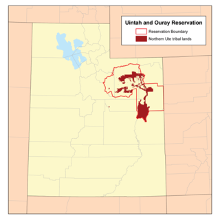
Chief Tabby-To-Kwanah was the leader of Timpanogos when they were displaced to the Uintah and Ouray Indian Reservation. He rose to power as a young man and was sub-chief under his cousin Chief Walkara when the Mormon pioneers first arrived in Timpanogos territory. He was one of the principal clan leaders over a band in southern Utah Valley, along with Chief Peteetneet and Grospene. He was a grandson of Turunianchi, who was the leader when the Timpanogos first contacted the Europeans during the Dominguez–Escalante Expedition. Turunianchi's grandsons made up the royal line of "brothers" referred to by Brigham Young. Tabby-To-Kwanah means "Child of the Sun." Tabiona, Utah is named after him.