Connecticut is the southernmost state in the New England region of the United States. As of the 2010 Census, it has the highest per-capita income, Human Development Index (0.962), and median household income in the United States. It is bordered by Rhode Island to the east, Massachusetts to the north, New York to the west, and Long Island Sound to the south. Its capital is Hartford and its most populous city is Bridgeport. It is part of New England, although portions of it are often grouped with New York and New Jersey as the Tri-state area. The state is named for the Connecticut River which approximately bisects the state. The word "Connecticut" is derived from various anglicized spellings of an Algonquian word for "long tidal river".

Westchester County is a county in the U.S. state of New York. It is the second-most populous county on the mainland of New York, after the Bronx, and the most populous county in the state north of New York City. According to the 2010 Census, the county had a population of 949,113, estimated to have increased by 3.3% to 980,244 by 2017. Situated in the Hudson Valley, Westchester covers an area of 450 square miles (1,200 km2), consisting of six cities, 19 towns, and 23 villages. Established in 1683, Westchester was named after the city of Chester, England. The county seat is the city of White Plains, while the most populous municipality in the county is the city of Yonkers, with an estimated 200,807 residents in 2016.

Fairfield County is an affluent county in the southwestern corner of the U.S. state of Connecticut. As of the 2010 census, the county's population was 916,829, estimated to have increased by 3.6% to 949,921 in 2017. The most populous county in the state, the county population represents a little over 25% of Connecticut's overall population and is one of its fastest-growing counties. The closest to New York City, the county contains four of the state's largest cities – Bridgeport (1st), Stamford (3rd), Norwalk (6th), and Danbury (7th) – whose combined population of 433,368 is nearly half the county's total population.

The Connecticut River is the longest river in the New England region of the United States, flowing roughly southward for 406 miles (653 km) through four states. It rises at the U.S. border with Quebec, Canada, and discharges at Long Island Sound. Its watershed encompasses five U.S. states and one Canadian province, 11,260 square miles (29,200 km2) via 148 tributaries, 38 of which are major rivers. It produces 70% of Long Island Sound's fresh water, discharging at 19,600 cubic feet (560 m3) per second.

Long Island Sound is a tidal estuary of the Atlantic Ocean, lying between the eastern shores of The Bronx, New York City, southern Westchester County, and Connecticut to the north, and the North Shore of Long Island, to the south. From west to east, the sound stretches 110 miles (177 km) from the East River in New York City, along the North Shore of Long Island, to Block Island Sound. A mix of freshwater from tributaries and saltwater from the ocean, Long Island Sound is 21 miles (34 km) at its widest point and varies in depth from 65 to 230 feet.

The Berkshires are a highland geologic region located in the western parts of Massachusetts and Connecticut. The term "Berkshires" is normally used by locals in reference to the portion of the Vermont-based Green Mountains that extend south into western Massachusetts; the portion extending further south into northwestern Connecticut is locally referred to as either the Northwest Hills or Litchfield Hills.

The Central New England Railway was a railroad from Hartford, Connecticut and Springfield, Massachusetts west across northern Connecticut and across the Hudson River on the Poughkeepsie Bridge to Maybrook, New York. It was part of the Poughkeepsie Bridge Route, an alliance between railroads for a passenger route from Washington to Boston, and was acquired by the New York, New Haven & Hartford Railroad in 1904.
Interstate 84 (I-84) is an Interstate Highway in the northeastern United States that extends from Dunmore, Pennsylvania, at an interchange with I-81 east to Sturbridge, Massachusetts, at an interchange with the Massachusetts Turnpike (I-90). Among the major cities that the road passes through is Hartford, Connecticut. I-84 has distance-based exit numbering in Pennsylvania. Otherwise, exit numbers are roughly sequential. Another highway named I-84 is located in the northwestern United States.

The Connecticut Panhandle is the southwestern appendage of Connecticut, where it abuts New York State. It is contained entirely in Fairfield County and includes all of Greenwich, Stamford, New Canaan, and Darien, as well as parts of Norwalk and Wilton. It has some of the most expensive residential real estate in the United States.

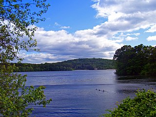
The Mianus River is a 20.3-mile-long (32.7 km) river in Westchester County, New York and Fairfield County, Connecticut, in the United States. It begins in the town of North Castle, New York in a series of ponds at about 600 feet (180 m) altitude. Flowing northeast into the town of Bedford, it abruptly turns south and passes through the Mianus River Gorge, a nature preserve, before entering Stamford, Connecticut, where it is dammed into the Mianus Reservoir, officially known as the Samuel J. Bargh Reservoir of the Greenwich Water Company. From there, it flows south through Stamford and Greenwich into Long Island Sound, at sea level.

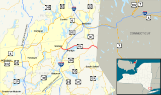
New York State Route 121 (NY 121) is a north–south state highway in the Hudson Valley of New York, United States. It begins in northern Westchester County at an intersection with NY 22 in Bedford and extends for 15.56 miles (25.04 km) to a junction with U.S. Route 6 and U.S. Route 202 east of the village of Brewster in Putnam County. As the route heads north, it briefly overlaps with NY 35 and NY 116 in Westchester County and connects to Interstate 84 (I-84) in Putnam County. NY 121 was assigned as part of the 1930 renumbering of state highways in New York.

The Old Connecticut Path was the Native American trail that led westward from the area of Massachusetts Bay to the Connecticut River Valley, the very first of the North American trails that led west from the settlements close to the Atlantic seacoast, towards the interior. The earliest colonists of Massachusetts Bay Colony used it, and rendered it wider by driving cattle along it. The old route is still followed, for part of its length, by Massachusetts Route 9 and Massachusetts Route 126.

This page is about a component of the New York City water supply system. For the hydrological feature with a similar name, see Croton River watershed
This page is about the Croton River watershed, a hydrological feature. For the component of the New York City water supply system with a similar name, see Croton Watershed