Tlake, Grosuplje

Last updated
Tlake
Tlake Grosuplje Slovenia 2.jpg
Slovenia location map.svg
Red pog.svg
Tlake
Location in Slovenia
Coordinates: 45°58′50.7″N14°35′42.44″E / 45.980750°N 14.5951222°E / 45.980750; 14.5951222 Coordinates: 45°58′50.7″N14°35′42.44″E / 45.980750°N 14.5951222°E / 45.980750; 14.5951222
Country Flag of Slovenia.svg Slovenia
Traditional region Lower Carniola
Statistical region Central Slovenia
Municipality Grosuplje
Area
  Total0.75 km2 (0.29 sq mi)
Elevation
300.9 m (987.2 ft)
Population
(2002)
  Total123
[1]

Tlake (pronounced  [ˈtlaːkɛ] ) is a settlement in the Municipality of Grosuplje in central Slovenia. It lies west of Šmarje–Sap on the road to Škofljica. The area is part of the historical region of Lower Carniola. The municipality is now included in the Central Slovenia Statistical Region. [2] The settlement consists of two parts: Spodnje Tlake and Zgornje Tlake (literally, 'lower Tlake' and 'upper Tlake'). [3]

Municipality of Grosuplje Municipality in Slovenia

The Municipality of Grosuplje is a municipality in central Slovenia. The seat of the municipality is the town of Grosuplje. It lies just south of the capital Ljubljana in the traditional region of Lower Carniola. It is now included in the Central Slovenia Statistical Region.

Slovenia republic in Central Europe

Slovenia, officially the Republic of Slovenia, is a sovereign state located in southern Central Europe at a crossroads of important European cultural and trade routes. It is bordered by Italy to the west, Austria to the north, Hungary to the northeast, Croatia to the southeast, and the Adriatic Sea to the southwest. It covers 20,273 square kilometers (7,827 sq mi) and has a population of 2.07 million. One of the successor states of the former Yugoslavia, Slovenia is a parliamentary republic and a member of the United Nations, of the European Union, and of NATO. The capital and largest city is Ljubljana.

Šmarje–Sap Place in Lower Carniola, Slovenia

Šmarje–Sap is a settlement in the Municipality of Grosuplje in central Slovenia. The area is part of the historical region of Lower Carniola. The municipality is now included in the Central Slovenia Statistical Region.

Contents

Name

Tlake was attested in written sources in 1436 as Tlakach. The name Tlake is derived from the Slovene common noun tlaka, originally referring to voluntary collective labor, and later to corvée under feudalism. It refers to a place where collective labor was performed. Because places with this name generally do not lie near old Roman roads, the suggestion that the name is derived from tlak 'pavement' is unlikely. [4] Zgornje Tlake was formerly known as Sveti Križ (literally, 'Holy Cross') after the local church, now located in Šmarje–Sap. [3]

Corvée

Corvée is a form of unpaid, unfree labour, which is intermittent in nature and which lasts limited periods of time: typically only a certain number of days' work each year.

Roman roads roads built in service of the Roman Empire

Roman roads were physical infrastructure vital to the maintenance and development of the Roman state, and were built from about 300 BC through the expansion and consolidation of the Roman Republic and the Roman Empire. They provided efficient means for the overland movement of armies, officials, and civilians, and the inland carriage of official communications and trade goods. Roman roads were of several kinds, ranging from small local roads to broad, long-distance highways built to connect cities, major towns and military bases. These major roads were often stone-paved and metaled, cambered for drainage, and were flanked by footpaths, bridleways and drainage ditches. They were laid along accurately surveyed courses, and some were cut through hills, or conducted over rivers and ravines on bridgework. Sections could be supported over marshy ground on rafted or piled foundations.

Road surface road covered with durable surface material

A road surface or pavement is the durable surface material laid down on an area intended to sustain vehicular or foot traffic, such as a road or walkway. In the past, gravel road surfaces, cobblestone and granite setts were extensively used, but these surfaces have mostly been replaced by asphalt or concrete laid on a compacted base course. Road surfaces are frequently marked to guide traffic. Today, permeable paving methods are beginning to be used for low-impact roadways and walkways. Pavements are crucial to countries such as US and Canada, which heavily depend on road transportation. Therefore, research projects such as Long-Term Pavement Performance are launched to optimize the life-cycle of different road surfaces.

History

Tlake was burned by Italian forces on 26 October 1941 in retaliation for a Partisan attack on a bunker next to the railroad tunnel. [3]

Yugoslav Partisans Yugoslavian resistance movement

The Yugoslav Partisans, or the National Liberation Army, officially the National Liberation Army and Partisan Detachments of Yugoslavia, was the Communist-led resistance to the Axis powers in occupied Yugoslavia during World War II.

Related Research Articles

Grosuplje Place in Lower Carniola, Slovenia

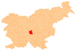
Grosuplje is a town in central Slovenia. It is the seat of the Municipality of Grosuplje. It lies just south of the capital Ljubljana in the traditional region of Lower Carniola. It is now included in the Central Slovenia Statistical Region.

Zgornje Škofije Place in Littoral, Slovenia

Zgornje Škofije is a village in the City Municipality of Koper in the Littoral region of Slovenia. The settlement is made up of the hamlets of Druga Škofija, Tretja Škofija, Četrta Škofija, and Rombi, in increasing elevation.

Tlake, Rogatec in Styria, Slovenia

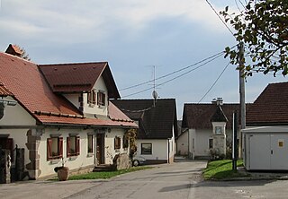
Tlake is a settlement in the Municipality of Rogatec in eastern Slovenia. The area traditionally belonged to the Styria region. It is now included in the Savinja Statistical Region.

Spodnje Gameljne Place in Upper Carniola, Slovenia

Spodnje Gameljne is a village on the right bank of the Sava River north of the capital Ljubljana in central Slovenia. It belongs to the City Municipality of Ljubljana. It was part of the traditional region of Upper Carniola and is now included with the rest of the municipality in the Central Slovenia Statistical Region.

Srednje Gameljne Place in Upper Carniola, Slovenia

Srednje Gameljne lies north of the capital Ljubljana in central Slovenia. It belongs to the City Municipality of Ljubljana. It was part of the traditional region of Upper Carniola and is now included with the rest of the municipality in the Central Slovenia Statistical Region.

Veliki Lipoglav Place in Lower Carniola, Slovenia

Veliki Lipoglav is a small settlement in the hills southeast of Ljubljana in central Slovenia. It belongs to the City Municipality of Ljubljana and is part of the traditional region of Lower Carniola. It is now included with the rest of the municipality in the Central Slovenia Statistical Region.

Tlaka, Litija in Lower Carniola, Slovenia

Tlaka is a settlement south of Gabrovka in the Municipality of Litija in central Slovenia. Traditionally the area was part of Lower Carniola and is now included with the rest of the municipality in the Central Sava Statistical Region.

Čolnišče Place in Upper Carniola, Slovenia

Čolnišče is a settlement west of Zagorje ob Savi in central Slovenia. The area is part of the traditional region of Upper Carniola. It is now included with the rest of the municipality in the Central Sava Statistical Region.

Močle in Styria, Slovenia

Močle is a village in the Municipality of Šmarje pri Jelšah in eastern Slovenia. It lies in the hills west of Šmarje. The area is part of the historical Styria region. The municipality is now included in the Savinja Statistical Region. It is a clustered village on the south side of a gentle slope. It includes the hamlets of Erpoge and Sveti Lovrenc.

Cikava, Grosuplje in Lower Carniola, Slovenia

Cikava is a small settlement in the Municipality of Grosuplje in central Slovenia. It lies halfway between Grosuplje and Šmarje–Sap on the old regional road leading towards Ljubljana. The area is part of the historical region of Lower Carniola. The municipality is now included in the Central Slovenia Statistical Region.

Žalna Place in Lower Carniola, Slovenia

Žalna is a settlement in the Municipality of Grosuplje in central Slovenia. It lies southeast of Grosuplje in the historical region of Lower Carniola. The municipality is now included in the Central Slovenia Statistical Region. It includes the hamlets of Prevale, Velika Žalna, and Mala Žalna, as well as part of the hamlet of Na Šoli.

Zgornja Slivnica Place in Lower Carniola, Slovenia

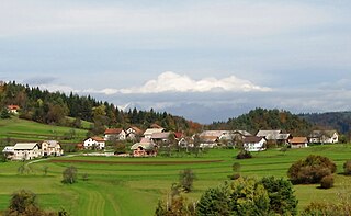
Zgornja Slivnica is a settlement in the Municipality of Grosuplje in central Slovenia. It lies in the hills north of Grosuplje and northeast of Šmarje-Sap and south of Mali Lipoglav in the historical region of Lower Carniola. The municipality is now included in the Central Slovenia Statistical Region.

Veliko Mlačevo Place in Lower Carniola, Slovenia

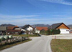
Veliko Mlačevo is a village in the Municipality of Grosuplje in central Slovenia. It lies just southeast of Grosuplje itself in the historical region of Lower Carniola. The municipality is now included in the Central Slovenia Statistical Region. The settlement includes the hamlet of Boštanj south of the main settlement.

Gajniče Place in Lower Carniola, Slovenia

Gajniče is a small settlement just southwest of Šmarje–Sap in the Municipality of Grosuplje in central Slovenia. The entire municipality is included in the Central Slovenia Statistical Region. The area is part of the historical region of Lower Carniola.

Hrastje pri Grosupljem in Lower Carniola, Slovenia

Hrastje pri Grosupljem is a settlement between Grosuplje and Šmarje-Sap in central Slovenia. The Slovenian A2 motorway runs across the settlement's territory. The area is part of the historical region of Lower Carniola. The Municipality of Grosuplje is now included in the Central Slovenia Statistical Region.

Paradišče Place in Lower Carniola, Slovenia

Paradišče is a settlement just east of Šmarje–Sap in the Municipality of Grosuplje in central Slovenia. The area is part of the historical region of Lower Carniola. The municipality is now included in the Central Slovenia Statistical Region.

Podgorica pri Šmarju in Lower Carniola, Slovenia

Podgorica pri Šmarju is a small settlement just north of Šmarje–Sap in the Municipality of Grosuplje in central Slovenia. The area is part of the historical region of Lower Carniola and is now included in the Central Slovenia Statistical Region.

Jerova Vas Place in Lower Carniola, Slovenia

Jerova Vas is a formerly independent settlement in the northern part of the town of Grosuplje in central Slovenia. It belongs to the Municipality of Grosuplje. It was part of the traditional region of Lower Carniola and is now included with the rest of the municipality in the Central Slovenia Statistical Region.

Stranska Vas (Grosuplje) Place in Lower Carniola, Slovenia

Stranska Vas is a formerly independent settlement in the northwest part of the town of Grosuplje in central Slovenia. It belongs to the Municipality of Grosuplje. It was part of the traditional region of Lower Carniola and is now included with the rest of the municipality in the Central Slovenia Statistical Region.

References

  1. Statistical Office of the Republic of Slovenia
  2. Grosuplje municipal site
  3. 1 2 3 Savnik, Roman, ed. 1971. Krajevni leksikon Slovenije, vol. 2. Ljubljana: Državna založba Slovenije, p. 154.
  4. Snoj, Marko. 2009. Etimološki slovar slovenskih zemljepisnih imen. Ljubljana: Modrijan and Založba ZRC, p. 429.