
Tolland County is a county located in the northeastern part of the U.S. state of Connecticut. As of the 2010 census, the population was 152,691. Tolland County is incorporated into thirteen towns and was originally formed on 13 October 1785 from portions of eastern Hartford County, Connecticut and western Windham County, Connecticut.

Windham County is a county located in the northeastern corner of the U.S. state of Connecticut. As of the 2010 census, the population was 118,428, making it the least populous county in Connecticut. It forms the core of the region known as the Quiet Corner.

Bolton is a small rural town in Tolland County, Connecticut, United States. It is primarily residential, with an economy made up primarily of small businesses. The high school typically has between fifty and one hundred students per grade. The population was 4,980 as of the 2010 census. Bolton was incorporated in October 1720 and is governed by town meeting. Bolton was named after a town of the same name in England.

Calvin Willey was an American politician from Connecticut who served in the United States Senate.
Shenipsit Lake, known locally as "The Snip", is a natural lake used as a water storage facility with a water size of 522.8 acres (2.116 km2) located in Tolland County, Connecticut, bordering the towns of Ellington, Tolland and the Rockville section of Vernon, Connecticut, at 41°53′4.7″N 72°25′34″W. It is the source of the Hockanum River.

Connecticut's 2nd Congressional District is a congressional district in the U.S. state of Connecticut. Located in the eastern part of the state, the district includes all of New London County, Tolland County, and Windham County, along with parts of Hartford, Middlesex, and New Haven counties.

This is a list of the National Register of Historic Places listings in Tolland County, Connecticut.

William Wallace Eaton was a United States Representative and United States Senator from Connecticut.
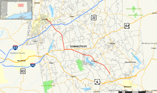
Route 31 is a north–south state highway in Connecticut running for 14.34 miles (23.08 km) from Route 74 in Vernon to Route 32 in Mansfield. Although it is officially logged as an east-west route, it is signed north-south.

Tolland High School is a public high school in Tolland, Connecticut.
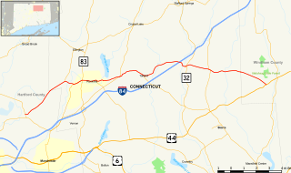
Route 74 is a state highway in Connecticut in the eastern part of the Greater Hartford area. It runs from Route 194 in South Windsor to US 44 in Ashford, going through the towns of Ellington, Vernon, Tolland, and Willington. East of its junction with I-84, it becomes a rural collector road.
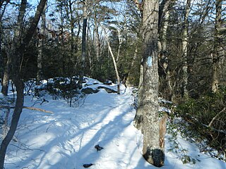
The Shenipsit Trail is a Blue-Blazed hiking trail located in Central Connecticut between 3.5 and 7 miles (11 km) east of the Connecticut River. It runs 50 miles (80 km) in a north-south direction. The southern trailhead is on Gadpouch Road in Cobalt, CT on the southern end of the Meshomasic State Forest. The northern trailhead is on Greaves Road past Bald Mountain and the Shenipsit State Forest in Stafford, CT. The trail runs primarily through the Shenipsit and Meshomasic State Forests, and Case Mountain, but also utilizes other public and private land holdings. The Native American name “Shenipsit” means “at the great pool,” referring to the Shenipsit Lake, which the trail passes by. The Shenipsit Trail is divided into three sections: South, Central, and North. The Shenipsit Trail is one of the blue-blazed hiking trails managed by the Connecticut Forest and Park Association (CFPA).

Route 195 is a state highway in northeastern Connecticut, running from the Willimantic section of Windham to the town center of Tolland via the Storrs section of Mansfield. The road is the main thoroughfare to access the main campus of the University of Connecticut.
The Hartford and Tolland Turnpike was a turnpike that once connected the statehouse in Hartford, Connecticut to the county courthouse in Tolland, Connecticut.

The Tolland Green Historic District is a historic district that includes the town green, Tolland Green, of the New England town of Tolland, Connecticut. The green is a long and narrow strip of land oriented in a north-south direction. The district includes the green and the surrounding properties. The historic district contains 55 contributing buildings and one other site, and is located primarily along Merrow Road from just south of Cider Mill Road in the south, past the Tolland Green, then widening in the north to encompass both Tolland Stage Road and the street known as Tolland Green to roughly Dunn Hill Road.
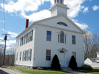
The Old Tolland County Court House is a historic former courthouse at 53 Tolland Green in Tolland, Connecticut. Built in 1822 it was used as a courthouse until 1892. It was used as a library for a number of years thereafter, and is now a museum operated by the Tolland Historical Society. The building was listed on the National Register of Historic Places in 1977.
The Hubbard River, 4.6 miles (7.4 km) long, is part of the Farmington River watershed. It flows through Connecticut and Massachusetts.

Burley Hill is a 1,316-foot (401 m) hill in Union, Connecticut. It is the highest point in Tolland County and the highest point in eastern Connecticut. It is one of Connecticut's highest named summits and it ranks 6th in the state for prominence at 669 feet.

