A Mediterranean climate or dry summer climate is characterized by rainy winters and dry summers, with less than 40 mm of precipitation for at least three summer months. While the climate receives its name from the Mediterranean Basin, these are generally located on the western coasts of continents, between roughly 30 and 43 degrees north and south of the equator, typically between oceanic climates towards the poles, and semi-arid and arid climates towards the equator.

Parry Sound is a town in Ontario, Canada, located on the eastern shore of the sound after which it is named. Parry Sound is located 160 km (99 mi) south of Sudbury and 225 km (140 mi) north of Toronto. It is a single tier government located in the territorial District of Parry Sound which has no second tier County, Regional or District level of government. Parry Sound is a popular cottage country region for Southern Ontario residents. It also has the world's deepest natural freshwater port.

The Dandenong Ranges are a set of low mountain ranges, rising to 633 metres at Mount Dandenong, approximately 35 km (22 mi) east of Melbourne, Victoria, Australia. The ranges consist mostly of rolling hills, steeply weathered valleys and gullies covered in thick temperate rainforest, predominantly of tall Mountain Ash trees and dense ferny undergrowth.

An oceanic climate, also known as a marine or maritime climate, is the Köppen classification of climate typical of west coasts in higher middle latitudes of continents, and generally features mild summers and mild winters, with a relatively narrow annual temperature range and few extremes of temperature, with the exception for transitional areas to continental, subarctic and highland climates. Oceanic climates are defined as having a monthly mean temperature below 22 °C (72 °F) in the warmest month, and above 0 °C (32 °F) in the coldest month.
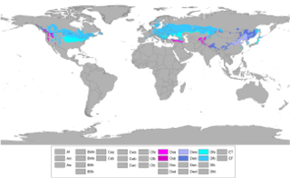
A humid continental climate is a climatic region defined by Russo-German climatologist Wladimir Köppen in 1900, typified by large seasonal temperature differences, with warm to hot summers and cold winters. Precipitation is usually distributed throughout the year. The definition of this climate regarding temperature is as follows: the mean temperature of the coldest month must be below −3 °C (26.6 °F) and there must be at least four months whose mean temperatures are at or above 10 °C (50 °F). In addition, the location in question must not be semi-arid or arid. The Dfb, Dwb and Dsb subtypes are also known as hemiboreal.
High Knob is the peak of Stone Mountain, that forms part of the border between Scott County and Wise County, Virginia, near the city of Norton that rises to 4,223 feet (1,287 meters) above mean sea level.

India has a large variation in climate from region to region, due to its vast size. India experiences climate from four major climate groups. These can be further subdivided into seven climatic types. For ecological regions, see Ecoregions of India, for Regions see List of regions of India.

Blairton is an unincorporated community on Opequon Creek located east of Martinsburg in Berkeley County, West Virginia. Blairton was originally named Opequan Station because of its location on the Opequon along the railroad.
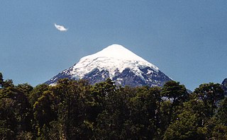
Lanín National Park is a national park of Argentina, located in the Neuquén Province, with forests of diverse tree varieties, mainly Fagaceae and conifers such as the lenga and the Araucaria, many species of which are not found elsewhere in Argentina.
Milwaukee has a humid continental climate, with four distinct seasons and wide variations in temperature and precipitation in short periods of time. The city's climate is also strongly influenced by nearby Lake Michigan, which creates two varying climates within the Milwaukee area. The Urban heat island effect also plays a role in the city's climate, insulating it from winter cold, but keeping it cooler in spring and summer.

The City and County of Denver, Colorado, is located at 39°43'35" North, 104°57'56" West in the Colorado Front Range region. The Southern Rocky Mountains lie to the west of Denver and the High Plains lie to the east.

Minnesota has a continental climate, with hot summers and cold winters. Minnesota's location in the Upper Midwest allows it to experience some of the widest variety of weather in the United States, with each of the four seasons having its own distinct characteristics. The areas near Lake Superior in the Minnesota Arrowhead region experience weather unique from the rest of the state. The moderating effect of Lake Superior keeps the surrounding area relatively cooler in the summer and relatively warmer in the winter, giving that region a smaller yearly temperature range. On the Köppen climate classification, much of the southern third of Minnesota—roughly from the Twin Cities region southward—falls in the hot summer humid continental climate zone (Dfa), and the northern two-thirds of Minnesota falls in the warm summer great continental climate zone (Dfb).

A historic snowstorm struck the Ohio Valley of the United States, as well as Ontario in Canada, on December 22 and December 23 and is not the same storm that led to snow in Texas on Christmas Eve. It lasted roughly 30 hours, and brought snowfall amounts up to 37 inches (73.7 cm) to portions of the Midwestern United States. Damages from the storm totaled US$900 million (2004 dollars). A total of 18 died during the storm, one from Canada, mainly due to car accidents.

Woody's Knob, at an elevation of 4,170 feet, is a summit or "knob" in the Blue Ridge Mountains and one of the highest points in the unincorporated village of Little Switzerland and in Mitchell County, North Carolina.

Italy has a variety of climate systems. The inland northern areas of Italy have a relatively cool, mid-latitude version of the Humid subtropical climate, while the coastal areas of Liguria and the peninsula south of Florence generally fit the Mediterranean climate profile.

Crested Butte is a prominent mountain summit in the Elk Mountains range of the Rocky Mountains of North America. The 12,168-foot (3,709 m) peak is located in Gunnison National Forest, 2.1 miles (3.4 km) northeast by east of the Town of Crested Butte in Gunnison County, Colorado, United States. Ski lifts and runs of the Crested Butte Mountain Resort occupy the north side of the mountain.

Glassy Mountain is a mountain in the Chattahoochee National Forest in Rabun County, Georgia, with its USGS GNIS summit at 34°50′44″N83°30′02″W, which is 3,415 feet (1,041 m) AMSL. It is bypassed on its northern flank by a major two-lane highway that carries U.S. Route 76 and Georgia State Route 2 east and west.
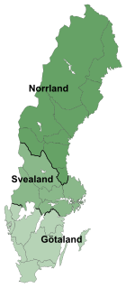
Sweden had a very unusual start and finish to the year 2010, with two consecutive winter cold waves occurring in a single calendar year. Since both events were notable, both are covered in this article.