
Rakiura National Park is a nature reserve park located on Stewart Island / Rakiura, New Zealand. It is the newest national park of New Zealand and opened in 2002. The protected area covers about 85% of the island.

In New Zealand, long distance walking or hiking for at least one overnight stay is known as tramping. There are a number of walkways in New Zealand, however most of these are relatively short and can be walked in a day or less. Many are also an easy walk, with well formed footpaths. However, some tracks require an overnight stay either because of the rugged country or the length of the track.

Mount Ngauruhoe is a volcanic cone in New Zealand. It is the youngest vent in the Tongariro stratovolcano complex on the Central Plateau of the North Island and first erupted about 2,500 years ago. Although often regarded as a separate mountain, geologically, it is a secondary cone of Mount Tongariro.
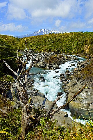
Tongariro National Park is the oldest national park in New Zealand, located in the central North Island. It has been acknowledged by UNESCO as a World Heritage Site of mixed cultural and natural values.

The Heaphy Track is a popular tramping and mountain biking track in the north west of the South Island of New Zealand. It is located within the Kahurangi National Park and classified as one of New Zealand's ten Great Walks by the Department of Conservation. Named after Charles Heaphy, the track is 78.4 kilometres (48.7 mi) long and is usually walked in four or five days. The track is open for shared use with mountain bikers in the winter season from 1 May to 30 September each year. The southern end of the track is at Kōhaihai, north of Karamea on the northern West Coast, and the northern end is in the upper valley of the Aorere River, Golden Bay.
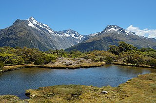
The Routeburn Track is a world-renowned, 32 km tramping (hiking) track found in the South Island of New Zealand. The track can be done in either direction, starting on the Queenstown side of the Southern Alps, at the northern end of Lake Wakatipu or on the Te Anau side, at the Divide, several kilometres from the Homer Tunnel to Milford Sound.

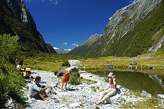
The Hollyford Track is a tramping track in New Zealand. Located at the northern edge of Fiordland, in the southwestern South Island, it is unusual among Fiordland's major tracks in that it is largely flat and accessible year-round. It follows the Hollyford River which in turn follows the course of the Hollyford Valley.
The Milford Track is a hiking route in New Zealand, located amidst mountains and temperate rain forest in Fiordland National Park in the southwest of the South Island. The 53.5 km (33.2 mi) hike starts at Glade Wharf at the head of Lake Te Anau and finishes in Milford Sound at Sandfly Point, traversing rainforests, wetlands, and an alpine pass.
The Tongariro Alpine Crossing in Tongariro National Park is a tramping track in New Zealand, and is among the most popular day hikes in the country. The Tongariro National Park is a World Heritage site which has the distinction of dual status, as it has been acknowledged for both its natural and cultural significance.

Te Araroa is New Zealand's long distance tramping route, stretching circa 3,000 kilometres (1,900 mi) along the length of the country's two main islands from Cape Reinga to Bluff. Officially opened in 2011, it is made up of a mixture of previously made tracks and walkways, new tracks, and link sections alongside roads. Tramping the full length of the trail generally takes three to six months.

The Kepler Track is a 60 km (37 mi) circular hiking track which travels through the landscape of the South Island of New Zealand and is situated near the town of Te Anau. The track passes through many landscapes of the Fiordland National Park such as rocky mountain ridges, tall mossy forests, lake shores, deep gorges, rare wetlands and rivers. Like the mountains it traverses, the track is named after Johannes Kepler. The track is one of the New Zealand Great Walks and is administered by the Department of Conservation (DOC).

The New Zealand Great Walks are a set of popular tramping tracks developed and maintained by the Department of Conservation. They are New Zealand's premier tracks, through areas of some of the best scenery in the country, ranging from coastlines with beaches to dense rain forests and alpine terrain. The tracks are maintained to a high standard, making it easier for visitors to explore some of the most scenic parts of New Zealand's backcountry.
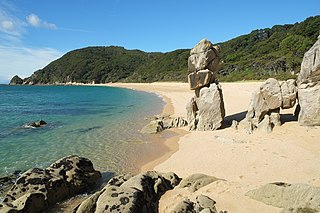
The Abel Tasman Coast Track is a 60 kilometres (37 mi) long walking track within the Abel Tasman National Park in New Zealand. It extends from Mārahau in the south to Wainui in the north, with many side tracks. It is one of two main tracks through the park, the other being the Abel Tasman Inland Track, which stretches for 38 km between Tinline Bay and Torrent Bay off the main coastal track. The coastal track is well sheltered, and with mild weather in all seasons, it is accessible and open throughout the year.

The Lake Waikaremoana Great Walk is a 44-kilometre (27 mi) tramping track which follows the southern and western coast of Lake Waikaremoana in the North Island of New Zealand. Passing through several types of forest, and grassland, the track often provides views over the lake. It is classified as one of New Zealand's Great Walks, and is located in the former Te Urewera National Park.

The Travers-Sabine Circuit is a popular tramping route in Nelson Lakes National Park, New Zealand. The full circuit takes about five to six days, although many side-trips are possible for longer tramps.

Craigieburn Forest Park is a protected area in the South Island of New Zealand, adjacent to Arthur's Pass National Park to the north.

The Fox River is a river in the Buller District of New Zealand. It arises in the Paparoa Range near Mount Dewar and flows north-west through the Paparoa National Park to the Tasman Sea at Woodpecker Bay. The river passes through a spectacular gorge. The northern branch of the river has limestone caves containing stalactite and stalagmite formations.
The Northern Crossing is a tramping track in New Zealand's Tararua Range. The track is approximately 50 kilometres (31 mi) long and typically takes between three and five days to complete. The crossing is suitable only for experienced trampers.

The Copland Track is a tramping track in the south Westland area of New Zealand's South Island, well known for the naturally-occurring hot springs at Welcome Flat along its route. The main track is approximately 25 kilometres (16 mi) long one-way from the trailhead at State Highway 6 to the track's inland end at the Douglas Rock Hut, and is usually completed in 2 to 4 days depending on whether the full distance is walked, with many opting to walk only as far as Welcome Flat. The track is the western portion of a longer path which historically connected the West Coast to Mount Cook Village via Copland Pass, however erosion and the retreat of the Hooker Glacier has led to the eastern side of this route becoming increasingly dangerous to traverse.

The historic Haast to Paringa Cattle Track is a trail through South Westland, New Zealand, constructed in 1875 to allow farmers in the Landsborough and Cascade Valley area to drive their cattle on an annual two-week journey to the sale yards in Whataroa. It was constructed as an inland loop to bypass the precipitous cliffs at Knights Point. For 90 years it was the only land access to the settlements of Haast and Jackson Bay, but the last mob of cattle was driven in 1961, and the construction of a highway connecting Paringa to Haast Pass in 1965 made it redundant. After falling into disuse, the cattle track was converted into a 33-kilometre (21 mi), three-day tramping track, opening in 1981. The track and its three huts are maintained by the New Zealand Department of Conservation.

