Topley Landing, British Columbia

Last updated
Topley Landing
Canada British Columbia location map 2.svg
Red pog.svg
Topley Landing
Location of Topley Landing in British Columbia
Coordinates: 54°48′44″N126°8′59″W / 54.81222°N 126.14972°W / 54.81222; -126.14972 Coordinates: 54°48′44″N126°8′59″W / 54.81222°N 126.14972°W / 54.81222; -126.14972
CountryFlag of Canada.svg  Canada
Province Flag of British Columbia.svg  British Columbia
Area code(s) 250, 778

Topley Landing is an unincorporated community at the outlet of the Fulton River on the western shore of Babine Lake in northwest British Columbia, Canada. [1]

Babine Lake lake

Babine Lake is the longest natural lake in British Columbia, Canada.

British Columbia Province of Canada

British Columbia is the westernmost province of Canada, located between the Pacific Ocean and the Rocky Mountains. With an estimated population of 5.016 million as of 2018, it is Canada's third-most populous province.

Canada Country in North America

Canada is a country in the northern part of North America. Its ten provinces and three territories extend from the Atlantic to the Pacific and northward into the Arctic Ocean, covering 9.98 million square kilometres, making it the world's second-largest country by total area. Canada's southern border with the United States is the world's longest bi-national land border. Its capital is Ottawa, and its three largest metropolitan areas are Toronto, Montreal, and Vancouver. As a whole, Canada is sparsely populated, the majority of its land area being dominated by forest and tundra. Consequently, its population is highly urbanized, with over 80 percent of its inhabitants concentrated in large and medium-sized cities, many near the southern border. Canada's climate varies widely across its vast area, ranging from arctic weather in the north, to hot summers in the southern regions, with four distinct seasons.

Contents

Topley Landing is located just off Highway 118. [1] It is within the Pacific Time Zone and observes daylight saving time. [2] The largest local settlement is Smithers, about 41 miles (65 km) west of Topley Landing. [3] Topley lies about 40 km to the south. [1]

Pacific Time Zone North American time zone

The Pacific Time Zone (PT) is a time zone encompassing parts of western Canada, the western United States, and western Mexico. Places in this zone observe standard time by subtracting eight hours from Coordinated Universal Time (UTC−08:00). During daylight saving time, a time offset of UTC−07:00 is used.

Daylight saving time Practice of advancing clocks so that evenings have more daylight and mornings have less

Daylight saving time (DST), also daylight savings time or daylight time, also summer time, is the practice of advancing clocks during summer months so that evening daylight lasts longer, while sacrificing normal sunrise times. Typically, regions that use daylight saving time adjust clocks forward one hour close to the start of spring and adjust them backward in the autumn to standard time. In effect, DST causes a lost hour of sleep in the spring and an extra hour of sleep in the fall.

Smithers, British Columbia Town in British Columbia, Canada

Smithers is a town in northwestern British Columbia, Canada, approximately halfway between Prince George and Prince Rupert. Smithers is located in the Regional District of Bulkley-Nechako. With a population of 5,351 in 2016, Smithers is a service area for most of the Bulkley Valley.

Description

The community has 83 homes, with a few full-time residents, most of the homes being seasonal dwellings for the large influx of tourists visiting in the summer months. The Sockeye fishery, which opens for six weeks from the beginning of August, attracts many campers and boaters to the area. [1]

The First Nations community of Tachet is nearby. [1]

History

Topley Landing dates back to 1822, when it was established by the Hudson's Bay Company for local natives to trade furs for other goods, [4] and named after an early settler, William J. Topley. [5] Catholic missionaries took up residence in 1848 and a small church was built. [4] A post office opened in 1921, followed by a one-room school, which was stocked with five hundred books by the retired Mr. Topley who was living in Alberta. [5]

Hudsons Bay Company Canadian retail business group

The Hudson's Bay Company is a Canadian retail business group. A fur trading business for much of its existence, HBC now owns and operates retail stores in Canada, the United States, and parts of Europe including Belgium, the Netherlands, and Germany. The company's namesake business division is Hudson's Bay, commonly referred to as The Bay. Other divisions include Galeria Kaufhof, Home Outfitters, Lord & Taylor and Saks Fifth Avenue. HBC's head office is currently located in Brampton, Ontario. The company is listed on the Toronto Stock Exchange under the symbol "HBC".

Catholic Church Christian church led by the Bishop of Rome

The Catholic Church, also known as the Roman Catholic Church, is the largest Christian church, with approximately 1.3 billion baptised Catholics worldwide as of 2017. As the world's "oldest continuously functioning international institution", it has played a prominent role in the history and development of Western civilisation. The church is headed by the Bishop of Rome, known as the Pope. Its central administration, the Holy See, is in the Vatican City, an enclave within the city of Rome in Italy.

A post office is a public department that provides a customer service to the public and handles their mail needs. Post offices offer mail-related services such as acceptance of letters and parcels; provision of post office boxes; and sale of postage stamps, packaging, and stationery. In addition, many post offices offer additional services: providing and accepting government forms, processing government services and fees, and banking services. The chief administrator of a post office is called a postmaster.

The church was used until 1988, when much of the population moved to nearby Granisle, where two copper mines had opened, and the church became disused. Then between 1993 and 1995 the old church building was relocated and restored, a pump organ was installed, and the church was opened to visitors in the warmer months and used for weddings, memorials and special occasions. [4]

Climate

Climate data for Topley Landing
MonthJanFebMarAprMayJunJulAugSepOctNovDecYear
Record high °C (°F) 10.0
(50)
12.8
(55)
16.0
(60.8)
24.5
(76.1)
33.0
(91.4)
32.8
(91)
34.4
(93.9)
33.5
(92.3)
31.0
(87.8)
24.5
(76.1)
17.8
(64)
11.0
(51.8)
34.4
(93.9)
Average high °C (°F) −5.0
(23)
−1.5
(29.3)
3.7
(38.7)
9.4
(48.9)
14.6
(58.3)
18.5
(65.3)
20.7
(69.3)
20.4
(68.7)
15.4
(59.7)
8.1
(46.6)
0.3
(32.5)
−3.9
(25)
8.4
(47.1)
Daily mean °C (°F) −8.5
(16.7)
−6.0
(21.2)
−1.6
(29.1)
3.6
(38.5)
8.4
(47.1)
12.4
(54.3)
14.6
(58.3)
14.1
(57.4)
9.7
(49.5)
4.0
(39.2)
−2.6
(27.3)
−6.9
(19.6)
3.4
(38.1)
Average low °C (°F) −12.0
(10.4)
−10.4
(13.3)
−6.9
(19.6)
−2.3
(27.9)
2.2
(36)
6.3
(43.3)
8.4
(47.1)
7.7
(45.9)
4.1
(39.4)
−0.2
(31.6)
−5.4
(22.3)
−9.8
(14.4)
−1.5
(29.3)
Record low °C (°F) −41.7
(−43.1)
−36.5
(−33.7)
−35.0
(−31)
−20.6
(−5.1)
−10.0
(14)
−1.7
(28.9)
0.0
(32)
−1.0
(30.2)
−4.5
(23.9)
−20.5
(−4.9)
−34.0
(−29.2)
−41.0
(−41.8)
−41.7
(−43.1)
Average precipitation mm (inches) 54.4
(2.142)
34.5
(1.358)
29.6
(1.165)
25.0
(0.984)
42.2
(1.661)
58.5
(2.303)
46.4
(1.827)
42.1
(1.657)
43.1
(1.697)
54.4
(2.142)
57.0
(2.244)
51.1
(2.012)
538.1
(21.185)
Average rainfall mm (inches) 4.9
(0.193)
3.6
(0.142)
4.7
(0.185)
16.8
(0.661)
40.6
(1.598)
58.5
(2.303)
46.4
(1.827)
42.1
(1.657)
43.1
(1.697)
42.8
(1.685)
14.6
(0.575)
3.8
(0.15)
322.0
(12.677)
Average snowfall cm (inches) 49.5
(19.49)
30.8
(12.13)
24.8
(9.76)
8.2
(3.23)
1.6
(0.63)
0.0
(0)
0.0
(0)
0.0
(0)
0.0
(0)
11.5
(4.53)
42.4
(16.69)
47.3
(18.62)
216.1
(85.08)
Average precipitation days (≥ 0.2 mm) 15.4 11.0 9.7 9.6 13.4 14.8 13.9 12.5 12.8 15.0 16.0 14.6 158.7
Average rainy days (≥ 0.2 mm) 2.2 1.6 3.3 7.6 13.0 14.8 13.9 12.5 12.8 13.6 5.7 1.8 102.8
Average snowy days (≥ 0.2 cm) 13.9 10.1 7.3 3.0 0.6 0.0 0.0 0.0 0.0 2.7 12.0 13.4 63.0
Mean monthly sunshine hours 45.2 90.7 156.9 201.9 237.4 232.0 260.0 243.5 173.0 100.0 42.0 28.4 1,811
Percent possible sunshine 18.5 33.2 42.8 47.8 47.6 44.9 50.2 52.6 45.2 30.6 16.5 12.5 36.9
Source: [6]

Topley Landing Provincial Park

Topley Landing Provincial Park, was established in 1964 along the western shore of the Lake. [7]

Related Research Articles

Pender Island Island in British Columbia, Canada

Pender Island is one of the Southern Gulf Islands located in the Gulf of Georgia, British Columbia, Canada. Pender Island is approximately 34 km2 (13 sq mi) in area and is home to about 2,250 permanent residents, as well as a large seasonal population. Like most of the rest of the Southern Gulf Islands, Pender Island enjoys a sub-Mediterranean climate and features open farmland, rolling forested hills, several lakes and small mountains, as well as many coves and beaches.

Highway 97 is the longest continuously numbered route in the Canadian province of British Columbia, running 2,081 km (1,293 mi) from the Canada–United States border near Osoyoos in the south to the British Columbia/Yukon boundary in the north at Watson Lake, Yukon. The route takes its number from U.S. Route 97, with which it connects at the international border. The highway was initially designated '97' in 1953.

Burns Lake Village in British Columbia, Canada

Burns Lake is a rural village in the North-Central Interior of British Columbia, Canada, incorporated in 1923. The village has a population of 2,029 according to the 2011 Census.

Watson Lake, Yukon Town in Yukon, Canada

Watson Lake is a town in Yukon, Canada located at mile 635 on the Alaska Highway close to the British Columbia border. The Canada 2016 Census put the population at 790, a drop of 1.5% from 802 in 2011. The town is named for Frank Watson, an American-born trapper and prospector, who settled in the area at the end of the nineteenth century.

Sicamous District municipality in British Columbia, Canada

Sicamous is a district municipality in British Columbia located adjacent to the Trans-Canada Highway at the Highway 97A junction, where Mara Lake empties into Shuswap Lake via a short narrows. Sicamous is a resort town about halfway between Calgary and Vancouver and is the eastern gateway to the Apple Country. With 341 km (212 mi) of shoreline, it styles itself as the houseboat capital of Canada. It has a population of 3,166.

Fort Fraser, British Columbia human settlement in Canada

Fort Fraser is an unincorporated community of about 500 people, situated near the base of Fraser Mountain, close to the village municipality of Fraser Lake and the Nechako River. It can be found near the geographical centre of British Columbia, Canada, 44 km (27 mi) west of Vanderhoof on the Yellowhead Highway. Originally established in 1806 as a North West Company fur trading post by the explorer Simon Fraser, it is one of present-day British Columbia's oldest permanent European-founded settlements. The area around the community is also recorded as the site of the first land in British Columbia cultivated by non-First Nations people.

Barriere, British Columbia District municipality in British Columbia, Canada

Barriere is a district municipality in central British Columbia, Canada, located 66 kilometres (41 mi) north of the larger city of Kamloops on Highway 5. It is situated at the confluence of the Barrière River and North Thompson Rivers in the Central North Thompson Valley.

Houston, British Columbia District municipality in British Columbia, Canada

Houston is a forestry, mining and tourism town in the Bulkley Valley of the Northern Interior of British Columbia, Canada. Its urban population is approximately 3600 people, with approximately 2000 in the surrounding rural area. It is known as the "steelhead capital" and it has the world's largest fly fishing rod. Houston's tourism industry is largely based on ecotourism and Steelhead Park, situated along Highway 16. Houston is named in honour of the pioneer newspaperman John Houston.

Highway 118, the Central Babine Lake Highway, is a 50 km (31 mi) long minor spur of the Yellowhead Highway in the Regional District of Bulkley-Nechako.

Wabasca, Alberta Hamlet in Alberta, Canada

Wabasca, also known as Wabasca-Desmarais, is a hamlet in northern Alberta, Canada, within the Municipal District of Opportunity No. 17. It is located between and along the South and North Wabasca Lakes, at the intersection of Highway 813 and Highway 754. It is approximately 123 kilometres (76 mi) northeast of Slave Lake.

Fraser Lake Village in British Columbia, Canada

Fraser Lake is a village in northern British Columbia, Canada. It's located on the southwest side of Fraser Lake between Burns Lake and Vanderhoof alongside the Yellowhead Highway.

Granisle Village in British Columbia, Canada

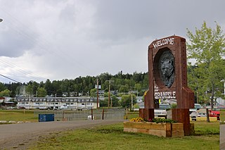
Granisle is a village on Babine Lake in the Northern Interior of British Columbia, Canada, to the north of Topley between Burns Lake and Houston.

Clo-oose Place in British Columbia, Canada

Clo-oose is a village of the Ditidaht people in the Canadian province of British Columbia. It is located just southwest of the west end of Nitinat Lake in Pacific Rim National Park Reserve on the west coast of Vancouver Island, about 65 kilometres (40 mi) south of Port Alberni. Its population is approximately 50 and consists of members of the Ditidaht First Nation. The village is located entirely on Claoose Indian Reserve No. 4 but the name refers to the locality beyond the reserve also, which has in the past had non-native residents.

Cortes Island island

Cortes Island is an island in the Discovery Islands archipelago on the coast of British Columbia, Canada. The island is 25 km (15.5 mi) long, 13 km (8.1 mi) wide, and 130 km2 (50 sq mi) in area. It has a population of 1,035 permanent residents. Cortes Island lies within Electoral Area B of the Strathcona Regional District, which provides water and sewerage systems, fire protection, land use planning, parks, recreation, and emergency response.

Spallumcheen District municipality in British Columbia, Canada

Spallumcheen is a district municipality in the Canadian province of British Columbia. Located in the Okanagan region between Vernon and Enderby, the township had a population of 5,055 and land area of 255.77 square kilometres (98.75 sq mi) in the Canada 2011 Census. The district, whose official name is the Township of Spallumcheen and which is the oldest rural municipality in the British Columbia Interior, consists primarily of agricultural land surrounding the separately incorporated City of Armstrong. Both Spallumcheen and Armstrong are member municipalities of the Regional District of North Okanagan.

Nechako Lakes (provincial electoral district)

Nechako Lakes is a provincial electoral district in British Columbia, Canada. It was established by the Electoral Districts Act, 2008, came into effect upon the dissolution of the British Columbia Legislature in April 2009, and was first contested in the 2009 election. The district includes the northern communities of Burns Lake, Vanderhoof, Houston and surrounding areas.

Carmi, British Columbia Place in British Columbia, Canada

Carmi is a ghost town in the Boundary Country region of British Columbia, Canada.The town is located on the west side of West Kettle River, east of Penticton, on Hwy 33. Carmi emerged as a silver mining camp just after the turn of the 20th century, named after the nearby mine. The mine in turn was named after the home town of James Dale, Carmi, Illinois.

Lake McArthur (British Columbia) lake in Canada

Lake McArthur is a lake in Yoho National Park, British Columbia, Canada, near the continental divide.

References

  1. 1 2 3 4 5 Regional District of Bulkley-Nechako Planning Department (7 November 2011). "Houston, Topley, Granisle Rural Official Community Plan" (PDF). Retrieved 8 January 2012.
  2. "Topley Landing (British Columbia): Community Profile". Roadside Thoughts. 20 December 2011. Retrieved 8 January 2012.
  3. "Topley Landing (British Columbia): Around the Neighborhood". Roadside Thoughts. 20 December 2011. Retrieved 8 January 2012.
  4. 1 2 3 Debi Smith (19 January 2004). "Topley Landing Angels". Hiway16 Magazine. Retrieved 8 January 2012.
  5. 1 2 G. P. V. Akrigg; Helen B. Akrigg (1997). British Columbia place names. UBC Press. p. 270. ISBN   978-0-7748-0637-4 . Retrieved 8 January 2012.
  6. "Calculation Information for 1981 to 2010 Canadian Normals Data". Environment Canada. Retrieved 9 July 2013.
  7. Ray Lowrey; British Columbia. Forest Service (1956). Report on recreational possibilities at Topley Landing. B.C. Forest Service. Retrieved 8 January 2012.