Lakes in the United States
| This disambiguation page lists articles about distinct geographical locations with the same name. If an internal link led you here, you may wish to change the link to point directly to the intended article. |
Toronto Lake may refer to:
| This disambiguation page lists articles about distinct geographical locations with the same name. If an internal link led you here, you may wish to change the link to point directly to the intended article. |

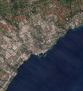
Lake Ontario is one of the five Great Lakes of North America. It is surrounded on the north, west, and southwest by the Canadian province of Ontario, and on the south and east by the American state of New York, whose water boundaries meet in the middle of the lake. Ontario, Canada's most populous province, was named for the lake. Many of Ontario's most populous cities, including Toronto, Canada's most populous city, and Hamilton, are on the lake's northern and western shores respectively. In the Huron language, the name Ontarí'io means "great lake". Its primary inlet is the Niagara River from Lake Erie. The last in the Great Lakes chain, Lake Ontario serves as the outlet to the Atlantic Ocean via the Saint Lawrence River. It is the only Great Lake not to border the state of Michigan.

Ontario is a province of Canada. Located in Central Canada, it is Canada's most populous province, with 38.3 percent of the country's population, and is the second-largest province in total area. Ontario is fourth-largest jurisdiction in total area when the territories of the Northwest Territories and Nunavut are included. It is home to the nation's capital city, Ottawa, and the nation's most populous city, Toronto, which is also Ontario's provincial capital.

Toronto is the provincial capital of Ontario and the most populous city in Canada, with a population of 2,731,571 as of 2016. Current to 2016, the Toronto census metropolitan area (CMA), of which the majority is within the Greater Toronto Area (GTA), held a population of 5,928,040, making it Canada's most populous CMA. The city is the anchor of the Golden Horseshoe, an urban agglomeration of 9,245,438 people surrounding the western end of Lake Ontario. Toronto is an international centre of business, finance, arts, and culture, and is recognized as one of the most multicultural and cosmopolitan cities in the world.

The Regional Municipality of York, also called York Region, is a regional municipality in Southern Ontario, Canada, between Lake Simcoe and Toronto. It replaced the former York County in 1971, and is part of the Greater Toronto Area and the inner ring of the Golden Horseshoe. The regional government is headquartered in Newmarket.
The Greater Toronto Area (GTA) is the most populous metropolitan area in Canada. It consists of the central city, Toronto, along with 25 surrounding cities and towns distributed among four regional municipalities: Durham, Halton, Peel, and York. According to the 2016 census, the Greater Toronto Area has a population of 6,417,516.

Yonge Street is a major arterial route in the Canadian province of Ontario connecting the shores of Lake Ontario in Toronto to Lake Simcoe, a gateway to the Upper Great Lakes. Until 1999, the Guinness Book of World Records repeated the popular misconception it was 1,896 km (1,178 mi) long, and thus the longest street in the world; this was due to a conflation of Yonge Street with the rest of Ontario's Highway 11. Yonge Street is actually 56 kilometres (35 mi) long. The construction of Yonge Street is designated an Event of National Historic Significance in Canada. Yonge Street was fundamental in the original planning and settlement of western Upper Canada in the 1790s, forming the basis of the concession roads in Ontario today. Once the southernmost leg of Highway 11, linking the provincial capital with northern Ontario, Yonge Street has been referred to as "Main Street Ontario". Today, no section of Yonge Street is a provincial highway.

Southern Ontario is a primary region of the province of Ontario, Canada, the other primary region being Northern Ontario. It is the most densely populated and southernmost region in Canada. The exact northern boundary of Southern Ontario is disputed; however, the core region is situated south of Algonquin Park, the latter being in an area of transition between coniferous forest north of the French and Mattawa Rivers and southern deciduous forest. It covers between 14 and 15% of the province, depending on the inclusion of the Parry Sound and Muskoka districts which also lie in the transitional area between northern and southern forest regions. With more than 12.7 million people, the region is home to approximately one-third of Canada's population of 35.1 million.
Parkdale was a Canadian federal electoral district represented in the House of Commons of Canada from 1917 to 1979. It included the community of Parkdale in the western part of Toronto, Ontario. It was created in 1914 from Toronto West, and continued to exist until 1976 when most of it was merged into Parkdale—High Park with some sections into Trinity.

Canada, in this historical context, was a French colony within New France first claimed in the name of the King of France in 1535 during the second voyage of Jacques Cartier. The word "Canada" at this point referred to the territory along the Saint Lawrence River, then known as the Canada river, from Grosse Island in the east to a point between Quebec and Trois-Rivières, although this territory had greatly expanded by 1600. French explorations continued "unto the Countreys of Canada, Hochelaga, and Saguenay" before any permanent settlements were established. Even though a permanent trading post and habitation was established at Tadoussac in 1600, at the confluence of the Saguenay and Saint Lawrence rivers, it was under a trade monopoly and thus not constituted as an official French colonial settlement.
Highland Creek may refer to:

The Ontario Hockey Association (OHA) is the governing body for the majority of junior and senior level ice hockey teams in the Province of Ontario. The OHA is sanctioned by the Ontario Hockey Federation along with the Northern Ontario Hockey Association. Other Ontario sanctioning bodies along with the OHF include the Hockey Eastern Ontario and Hockey Northwestern Ontario. The OHA control 3 tiers of junior hockey; the "Tier 2 Junior "A", Junior "B", Junior "C", and one senior hockey league, Allan Cup Hockey.

Scarborough Southwest is a federal electoral district in Toronto, Ontario, Canada, that has been represented in the House of Commons of Canada since 1968.

Broadview was a federal electoral district in Ontario, Canada, that was represented in the House of Commons of Canada from 1935 to 1979. This riding was created in 1933 from parts of Toronto East and Toronto—Scarborough ridings.
High Park was a federal electoral district in the west-end of the old City of Toronto, in Ontario, Canada. It was represented in the House of Commons of Canada from 1935 to 1972. It was created in 1933 and abolished in 1972, when it was redistributed into the newly created High Park—Humber Valley district, which shared virtually the same boundaries as High Park's last incarnation.
High Park—Humber Valley was a federal electoral district in the west-end of the old Metropolitan Toronto, in Ontario, Canada. It was represented in the House of Commons from 1972 to 1979. It was created in 1972 from the High Park district, maintaining the same boundaries as the former district. It was abolished in 1976, but the next election did not occur until almost three-years later. Its only Member of Parliament was Otto Jelinek.
King's Highway 108, commonly referred to as Highway 108, is a provincially maintained highway in the Canadian province of Ontario. Located in the Algoma District in the mid-north region, just above Lake Huron, of the province, the highway extends for 41.6 kilometres (25.8 mi) from an intersection with Highway 17 west of Serpent River, through the urban core of Elliot Lake, to an intersection with Quirke Mine Road in the north end of the city. The highway continues as Secondary Highway 639 north of Quirke Mine Road.

West Rouge is a small community neighbourhood in Toronto, Ontario, Canada. It is located in the south-east corner of Toronto, within the former city of Scarborough. The community is roughly bounded by Lake Ontario to the south, the Rouge River to the east, Port Union Road to the west and Kingston Road to the north.

Rouge is a neighbourhood in the northeastern area of Toronto, Ontario, within the former city of Scarborough. It is Toronto's largest neighbourhood by surface area; however, unlike other neighbourhoods, most of its area remains undeveloped, as the neighbourhood is adjacent to Rouge National Urban Park.
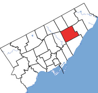
Scarborough Centre is a provincial electoral district in Ontario, Canada, that has been represented in Legislative Assembly of Ontario since 1963.