Scouting in Indiana has a long history, from the 1910s to the present day, serving thousands of youth in programs that suit the environment in which they live.

Comstock Park is a census-designated place and unincorporated community in Alpine Township and Plainfield Township, Kent County, Michigan, in the Grand Rapids metropolitan area, United States. As of the 2010 census, the community had a population of 10,088, with the majority (9,044) living in Alpine Township.

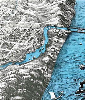
The Calumet River is a system of heavily industrialized rivers and canals in the region between the neighborhood of South Chicago in Chicago, Illinois, and the city of Gary, Indiana. Historically, the Little Calumet River and the Grand Calumet River were one, the former flowing west from Indiana into Illinois, then turning back east to its mouth at Lake Michigan at Marquette Park in Gary.

Indiana Dunes National Park is a United States National Park located in Northwestern Indiana, managed by the National Park Service. It was authorized by Congress in 1966 as the Indiana Dunes National Lakeshore, the name by which it was known until it was designated the nation's newest and 61st national park on February 15, 2019. The park runs for nearly 25 miles (40 km) along the southern shore of Lake Michigan; it contains approximately 15,000 acres (6,100 ha). Its visitors center is in Porter, Indiana. Located in the park are sand dune, wetland, prairie, river, as well as forest ecosystems.

Allegan State Game Area is a 50,000-acre (200 km2) forest attracting campers, hikers, bikers snowmobilers, cross-country skiers, horse trail riders and hunters. It is located in west-central Allegan County, Michigan. One gateway is just west of the city of Allegan. It is more commonly referred to as Allegan Forest.

The American Discovery Trail is a system of recreational trails and roads which collectively form a coast-to-coast hiking and biking trail across the mid-tier of the United States. Horses can also be ridden on most of this trail. It starts on the Delmarva Peninsula on the Atlantic Ocean and ends on the northern California coast on the Pacific Ocean. The trail has northern and southern alternates for part of its distance, passing through Chicago and St Louis respectively. The total length of the trail including both the north and south routes is 6,800 miles (10,900 km). The northern route covers 4,834 miles (7,780 km) with the southern route covering 5,057 miles (8,138 km). It is the only non-motorized coast-to-coast trail.
The St. Joseph River is a 206 miles (332 km) long tributary of Lake Michigan flowing generally westerly through southern Michigan and northern Indiana, United States, to its terminus on the southeast shore of the lake. It drains a primarily rural farming area in the watershed of Lake Michigan. It was enormously important to Native Americans and greatly aided in the colonial exploration, settlement and administration of New France and the nascent United States as a canoe route between Lake Michigan and the watershed of the Mississippi River.
The Lake Shore and Michigan Southern Railway, established in 1833 and sometimes referred to as the Lake Shore, was a major part of the New York Central Railroad's Water Level Route from Buffalo, New York, to Chicago, Illinois, primarily along the south shore of Lake Erie and across northern Indiana. The line's trackage is still used as a major rail transportation corridor and hosts Amtrak passenger trains, with the ownership in 1998 split at Cleveland between CSX to the east, and Norfolk Southern in the west.

Indiana Dunes State Park is an Indiana State Park located in Porter County, Indiana, United States, 47 miles (75.6 km) east of Chicago. The park is bounded by Lake Michigan to the northwest, and is surrounded on all four sides by Indiana Dunes National Park, a unit of the National Park Service; the national park owns the water from the ordinary high water mark to 300 feet (91 m) offshore. The 1,530-acre (619.2 ha) Dunes Nature Preserve makes up the bulk of eastern part of the park, and includes most of the park’s hiking trails and dune landscape. This was one of the first places Richard Lieber considered when establishing the Indiana State Park system. Like all Indiana state parks, there is a fee for entrance. Indiana Dunes State Park was established in 1925 and designated a National Natural Landmark in 1974.
The Grand Illinois Trail is a multipurpose recreational trail in the northern part of the U.S. state of Illinois. At over 575 miles (925 km) in length, it is the longest trail in Illinois. Parts of it are in the coast-to-coast American Discovery Trail.
Stony Creek Metropark is a Huron-Clinton Metropark located in southeast Michigan in the outskirts of metro Detroit. The park is predominantly in Washington Township and Oakland Township, with a small portion in Shelby Township. The park covers 4,461 acres (18.05 km2) with Stony Creek Lake at its center.
French Creek State Park is a 7,526-acre (3,046 ha) Pennsylvania state park in North Coventry and Warwick Townships in Chester County and Robeson and Union Townships in Berks County, Pennsylvania in the United States. It straddles northern Chester County and southern Berks County along French Creek. It is located in the Hopewell Big Woods. The park is the home of two lakes: Hopewell Lake, a 68-acre (28 ha) warm water lake, and Scotts Run Lake, a 22-acre (8.9 ha) cold water lake. The state record smallmouth bass was caught in Scotts Run Lake. There are extensive forests, and almost 40 miles (64 km) of hiking and equestrian trails. The park is also friendly to mountain bikers, having some renowned technical trails. Hopewell Furnace National Historic Site, which features a cold blast furnace restored to its 1830s appearance, is surrounded by the park. The Six Penny Day Use Area and Group Camp are listed on the National Register of Historic Places. French Creek State Park is located off of Pennsylvania Route 345 to the south of Birdsboro.

Cowles Bog is an 8,000-year-old fen in Indiana Dunes National Park, near Chesterton, Indiana. It is named for Dr. Henry Chandler Cowles who did his pioneering work in ecology and ecological succession here. His work brought international attention to the area which led to efforts to preserve the Indiana Dunes. It was designated a National Natural Landmark in 1965.

Westchester Township is one of twelve townships in Porter County, Indiana. It is included in the Calumet, Northwest Indiana, and Great Lakes regions. It is located on the southern shore of Lake Michigan, about 50 miles (80 km) southeast of Chicago. It stretches from the famous Indiana Dunes on its northern border, south to the Valparaiso Moraine, a ridge of rolling hills left by the last glacier to pass through the area. As of the 2010 census, its population was 19,396.

The Kankakee Outwash Plain is a flat plain interspersed with sand dunes in the Kankakee River valley in northwestern Indiana and northeastern Illinois of the United States. It is just south of the Valparaiso Moraine and was formed during the Wisconsin Glaciation. As the glacier, stopped at the Valparaiso Moraine, melted, the meltwater was carried away to the outwash plain. On the south side of the moraine, where the elevation drops, the meltwaters eroded away valleys, carrying sand and mud with them. As the muddy meltwater reached the valley where the slope lessened, the water slowed down, depositing the sand on the outwash plain. This created a smooth, flat, and sandy plain. Before its draining, the Kankakee Marsh, located on the outwash plain, was one of the largest freshwater marshes in the United States.
The Great Lakes Circle Tour is a designated scenic road system connecting all of the Great Lakes and the St. Lawrence River. It consists of routes for circumnavigating the lakes, either individually or collectively.

Salt Creek is a 24.0-mile-long (38.6 km) tributary of the East Arm Little Calumet River that begins south of Valparaiso in Porter County, Indiana and flows north until it joins the East Arm Little Calumet River just before it exits to Lake Michigan via the Port of Indiana-Burns Waterway.

Paint Creek Trail is an 8.9-mile (14.3 km) rail trail linear park in northeast Oakland County, Michigan. The course of the park generally follows Paint Creek, a stream that flows southeast towards the Clinton River.