
Lincoln is the capital city of the U.S. state of Nebraska and the county seat of Lancaster County. The city covers 100.4 square miles (260.035 km2) with a population of 292,657 in 2021. It is the state's 2nd most populous city and the 73rd-largest in the United States. Lincoln is the economic and cultural anchor of a substantially larger metropolitan area in southeastern Nebraska, the Lincoln Metropolitan and Lincoln-Beatrice Combined Statistical Areas. The statistical area is home to 361,921 people, making it the 104th-largest combined statistical area in the United States.

The Blue Ridge Parkway is a National Parkway and All-American Road in the United States, noted for its scenic beauty. The parkway, which is the longest linear park in the U.S., runs for 469 miles (755 km) through 29 counties in Virginia and North Carolina, linking Shenandoah National Park to Great Smoky Mountains National Park. It runs mostly along the spine of the Blue Ridge, a major mountain chain that is part of the Appalachian Mountains. Its southern terminus is at U.S. Route 441 (US 441) on the boundary between Great Smoky Mountains National Park and the Qualla Boundary of the Eastern Band of Cherokee Indians in North Carolina, from which it travels north to Shenandoah National Park in Virginia. The roadway continues through Shenandoah as Skyline Drive, a similar scenic road which is managed by a different National Park Service unit. Both Skyline Drive and the Virginia portion of the Blue Ridge Parkway are part of Virginia State Route 48 (SR 48), though this designation is not signed.

The American Discovery Trail is a system of recreational trails and roads that collectively form a coast-to-coast hiking and biking trail across the mid-tier of the United States. Horses can also be ridden on most of this trail. The coastal trailheads are the Delmarva Peninsula on the Atlantic Ocean and the northern California coast on the Pacific Ocean. The trail has northern and southern alternates for part of its distance, passing through Chicago and St. Louis respectively. The total length of the trail, including both the north and south routes, is 6,800 miles (10,900 km). The northern route covers 4,834 miles (7,780 km) with the southern route covering 5,057 miles (8,138 km). It is the only non-motorized coast-to-coast trail.
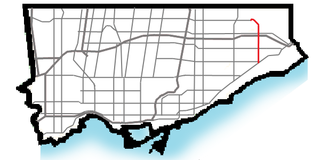
Morningside Avenue is a suburban arterial road in Toronto, Ontario, Canada. It is entirely within Scarborough, running north by north-west from the Scarborough Bluffs overlooking Lake Ontario to the eastern terminus of McNicoll Avenue near the Rouge River valley. A short extension from Steeles Avenue to Passmore Avenue has been completed but the connection to the southern section to McNicoll Avenue is still not completed.

The main segment of the Los Gatos Creek Trail is a 9.7-mile (15.6 km) pedestrian and bicycle trail that runs through western Santa Clara County in California. It runs from Lexington Reservoir in Los Gatos, California through Campbell, California to Meridian Avenue in San Jose, California alongside Los Gatos Creek.

Delaware Route 2 (DE 2) is a 10.81-mile-long (17.40 km) east–west state highway located in the northern part of New Castle County in the U.S. state of Delaware. It runs from DE 72 and DE 273 on the eastern edge of Newark east to DE 52 in Wilmington. Between Newark and Wilmington, the route is a four- to six-lane divided highway called Capitol Trail and Kirkwood Highway that passes through suburban areas, running through Marshallton, Prices Corner, and Elsmere. In Wilmington, DE 2 is routed along the one-way pair of Lincoln Street eastbound and Union Street westbound, passing through urban areas.
The Jamaica North Trail is a 6.5-mile-long (10.5 km) pedestrian and cycling trail running through southwest Lincoln, Nebraska, USA.

Boulevards in Omaha are part of a park and boulevard system originally designed in 1889 by Horace Cleveland. There are more than one hundred miles (160 km) of boulevards throughout the city of Omaha, Nebraska today.

The Lincoln Highway in Omaha, Nebraska, runs east–west from near North 183rd Street and West Dodge Road in Omaha, Nebraska, towards North 192nd Street outside of Elkhorn. This section of the Lincoln Highway, one of only 20 miles (32 km) that were paved with brick in Nebraska, is one of the most well-preserved in the country. The roadway was listed on the National Register of Historic Places in 1984. The Lincoln Highway was the first road across the United States, traversing coast-to-coast from Times Square in New York City to Lincoln Park in San Francisco, California.

Transportation in Omaha, Nebraska, includes most major modes, such as pedestrian, bicycle, automobile, bus, train and airplane. While early transportation consisted of ferries, stagecoaches, steamboats, street railroads, and railroads, the city's transportation systems have evolved to include the Interstate Highway System, parklike boulevards and a variety of bicycle and pedestrian trails. The historic head of several important emigrant trails and the First transcontinental railroad, its center as a national transportation hub earned Omaha the nickname "Gate City of the West" as early as the 1860s.

U.S. Route 202 is a US Highway running from New Castle, Delaware, northeast to Bangor, Maine. The route runs through the southeastern part of the U.S. state of Pennsylvania, passing through the western and northern suburbs of Philadelphia in the Delaware Valley metropolitan area. US 202 serves largely as a toll-free bypass around the city, avoiding the busy traffic and congestion on Interstate 95 (I-95). It is signed north–south and follows a general southwest–northeast direction through the state, serving West Chester, King of Prussia, Bridgeport, Norristown, Montgomeryville, Doylestown, and New Hope. US 202 enters Pennsylvania from Delaware and heads north as a divided highway, where it becomes concurrent with US 322 at an intersection with US 1 in Painters Crossing. The two routes run north and become a freeway that bypasses West Chester to the east, with US 322 splitting from US 202. US 202 continues north and east along the freeway to King of Prussia, where it reverts to an at-grade divided highway following an interchange with I-76. The route becomes a one-way pair as it passes through Bridgeport and Norristown before both directions rejoin and the road continues northeast. US 202 follows an expressway-grade parkway between Montgomeryville and Doylestown prior to bypassing Doylestown to the south along a freeway. The route continues northeast as an at-grade road to New Hope, where it turns into a freeway again before it crosses the Delaware River on the New Hope–Lambertville Toll Bridge into New Jersey.

Capitol View is a historic intown southwest Atlanta, Georgia neighborhood. The neighborhood is 2.5 miles from downtown and was named for its views of the Georgia State Capitol building. Its boundaries include Metropolitan Parkway to the east, Lee Street to the west, and the Beltline to the north. On the south, the border follows Arden Street, Deckner Avenue, and Perkerson Park.
The Antelope Valley Project is a flood control, economic development, transportation and community revitalization project in Lincoln, Nebraska. Centered on the flood control channel provided for Lincoln's Antelope Creek, the project is planned to run from just beyond J Street in the South to Salt Creek to the North, with the creek fully contained within the channel. The total cost of the project is $238,000,000. The project is the largest public works project in the history of the city.

Kern County’s transportation system was quoted as the “unseen industry.” Located at the southern end of the San Joaquin Valley, the county is at a prime location to ship goods west to the central coast, south to ports in Los Angeles, and east to corridors that connect to the rest of the country. It is also on major corridors that link to all northern points.
Clive Greenbelt Trail is an 11.3 miles (18.2 km) urban recreational trail in Clive, Iowa and forms part of the Central Iowa Trails network. This very busy recreational trail runs through Polk and Dallas Counties in Iowa. It is a curvy, paved asphalt and concrete trail.
Wilderness Park is a 1,472-acre (596 ha) mostly-public conservancy located in southwest Lincoln, Nebraska. The park is the largest in Lincoln and is separated into several branches. S 14th St, a north-south street dissects much of the south end of the park.

Lincoln, Nebraska has many neighborhoods, including 45 recognized by Urban Development, City of Lincoln. A list and description of neighborhoods within Lincoln city limits follows.
The following is a timeline of Lincoln, Nebraska history including significant social, political, cultural, and economic events in the history of Lincoln.

The Rock Creek Trails are a series of trails through the Rock Creek valley and along the Potomac River in Washington, DC and Montgomery County, MD. The main route extends 22 miles from Lake Needwood in Maryland to the Inlet Bridge in Washington, DC, with a loop in the north part of Rock Creek Park and other trails through the Klingle Valley, Turkey Branch Valley and along the North Branch of Rock Creek. There are three separate trails that make up the main Rock Creek Trail route and others that connect to it. Along the Potomac River from Arlington Memorial Bridge to Rock Creek is a section sometimes called the Shoreline Trail.