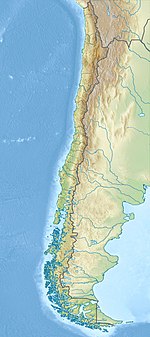
The Magallanes Basin or Austral Basin is a major sedimentary basin in southern Patagonia. The basin covers a surface of about 170,000 to 200,000 square kilometres and has a NNW-SSE oriented shape. The basin is bounded to the west by the Andes mountains and is separated from the Malvinas Basin to the east by the Río Chico-Dungeness High. The basin evolved from being an extensional back-arc basin in the Mesozoic to being a compressional foreland basin in the Cenozoic. Rocks within the basin are Jurassic in age and include the Cerro Toro Formation. Three ages of the SALMA classification are defined in the basin; the Early Miocene Santacrucian from the Santa Cruz Formation and Friasian from the Río Frías Formation and the Pleistocene Ensenadan from the La Ensenada Formation.
Chilenosuchus is an extinct genus of aetosaur. Fossils have been found in the El Bordo Formation, in the Antofagasta Region in northern Chile.

The South American land mammal ages (SALMA) establish a geologic timescale for prehistoric South American fauna beginning 64.5 Ma during the Paleocene and continuing through to the Late Pleistocene. These periods are referred to as ages, stages, or intervals and were established using geographic place names where fossil materials where obtained.
The Divisaderan age is a South American land mammal age, covering a period of geologic time within the Late Eocene epoch of the Paleogene. It follows the Mustersan age and is followed by the Tinguirirican age.
The Colhuehuapian age is a period of geologic time within the Early Miocene epoch of the Neogene, used more specifically within the SALMA classification in South America. It follows the Deseadan and precedes the Santacrucian age.
The Laventan age is a period of geologic time within the Middle Miocene epoch of the Neogene, used more specifically within the SALMA classification in South America. It follows the Colloncuran and precedes the Mayoan age.
The Chasicoan age is a period of geologic time from 10—9 Ma within the Late Miocene epoch of the Neogene, used more specifically within the SALMA classification in South America. It follows the Mayoan and precedes the Huayquerian age.

The Chacarilla Formation is an Oxfordian to Early Cretaceous geologic formation of the Tarapacá Basin in northern Chile, close to the border with Bolivia. The marine and fluvial formation preserves several dinosaur trackways and has been declared a Natural Sanctuary in 2004.

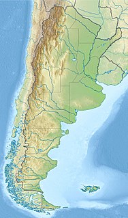
Neuquén Basin is a sedimentary basin covering most of Neuquén Province in Argentina. The basin originated in the Jurassic and developed through alternating continental and marine conditions well into the Tertiary. The basin bounds to the west with the Andean Volcanic Belt, to the southeast with the North Patagonian Massif and to the northeast with the San Rafael Block and to the east with the Sierra Pintada System. The basin covers an area of approximately 120,000 square kilometres (46,000 sq mi). One age of the SALMA classification, the Colloncuran, is defined in the basin, based on the Collón Curá Formation, named after the Collón Curá River, a tributary of the Limay River.

Arctotherium is an extinct genus of Central and South American short-faced bears within Ursidae of the Pleistocene. Their ancestors migrated from North America to South America during the Great American Interchange, following the formation of the Isthmus of Panama during the late Pliocene. The oldest confirmed remains are from the Ensenadan epoch within the Early to Middle Pleistocene 1.2 Mya with a tooth possibly belonging to Arctotherium dating about 2.588 Mya. Their closest known relative is the spectacled bear.
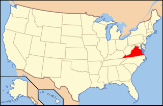
Paleontology in Virginia refers to paleontological research occurring within or conducted by people from the U.S. state of Virginia. The geologic column in Virginia spans from the Cambrian to the Quaternary. During the early part of the Paleozoic, Virginia was covered by a warm shallow sea. This sea would come to be inhabited by creatures like brachiopods, bryozoans, corals, and nautiloids. The state was briefly out of the sea during the Ordovician, but by the Silurian it was once again submerged. During this second period of inundation the state was home to brachiopods, trilobites and entire reef systems. During the mid-to-late Carboniferous the state gradually became a swampy environment.
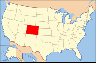
Paleontology in Colorado refers to paleontological research occurring within or conducted by people from the U.S. state of Colorado. The geologic column of Colorado spans about one third of Earth's history. Fossils can be found almost everywhere in the state but are not evenly distributed among all the ages of the state's rocks. During the early Paleozoic, Colorado was covered by a warm shallow sea that would come to be home to creatures like brachiopods, conodonts, ostracoderms, sharks and trilobites. This sea withdrew from the state between the Silurian and early Devonian leaving a gap in the local rock record. It returned during the Carboniferous. Areas of the state not submerged were richly vegetated and inhabited by amphibians that left behind footprints that would later fossilize. During the Permian, the sea withdrew and alluvial fans and sand dunes spread across the state. Many trace fossils are known from these deposits.
Abanico Formation is a 3 kilometres (9,800 ft) thick sedimentary formation exposed in the Andes of Central Chile. The formation has been deposited in a timespan from the Eocene to the Miocene. Abanico Formation's contact with the overlying Miocene Farellones Formation has been the subject of differing interpretations since the 1960s. A small part of the formation crops out in the Mendoza Province of western Argentina.
Nacientes del Biobío Formation is a geological formation that crops out near the uppermost reaches of Bío Bío River, in south-central Chile, and nearby areas of Argentina. The formation is made up of basalt and pyroclastic rocks and marine sedimentary rocks, such as sandstone and mudstone. Some less abundant sedimentary lithologies are conglomerate, volcaniclastic sedimentary rock. The formation is intruded by Grupo Plutónico Galletué which is of Late Jurassic to Late Cretaceous age. Further north in Chile the formation is similar to Nacientes del Teno Formation while in Argentina it is similar to Los Molles Formation and Lotena Formation.
Panguipulli Formation is a sedimentary formation of Triassic age located in Los Ríos Region and southernmost Araucanía Region in south–central Chile. The formation is variously covered by Quaternary lavas in the east and Quaternary morraines, Holocene alluvium and colluvium in the west. The formation and make up possibly the remnants of an ancient lake and river system. The formation is named after the town of Panguipulli on the western edge of Panguipulli Lake. The formation has evidence of low grade metamorphism and is locally intruded by plutons of the North Patagonian Batholith that are of Jurassic, Cretaceous and Miocene age.
Loreto Formation is a sedimentary formation of Late Eocene age in the southernmost Magallanes Basin. It overlies the Leña Dura Formation and the contact with an overlying formation is not observed.
Río Frías Formation is a Middle Miocene geologic formation made up sedimentary rock located in Aysén Region, western Patagonia. The formation crops out along the upper couse of Cisnes River. Marsupial fossils have been found in the formation. The Friasian period in the South American Land Mammal Ages is named after the formation.
The geology of Utah includes rocks formed at the edge of the proto-North American continent during the Precambrian. A shallow marine sedimentary environment covered the region for much of the Paleozoic and Mesozoic, followed by dryland conditions, volcanism and the formation of the basin and range terrain in the Cenozoic. Utah is a state in the western United States.
The Bajada Colorada Formation is a geologic formation of the southern Neuquén Province in the Neuquén Basin of northern Patagonia, Argentina. The formation belongs to the Mendoza Group and is Late Berriasian to Early Valanginian in age. The formation is renowned for preserving fossil remains of Bajadasaurus pronuspinax, a genus of dicraeosaurid dinosaurs named after the formation.
The Cañadón Asfalto Basin is an irregularly shaped sedimentary basin located in north-central Patagonia, Argentina. The basin stretches from and partly covers the North Patagonian Massif in the north, a high forming the boundary of the basin with the Neuquén Basin in the northwest, to the Cotricó High in the south, separating the basin from the Golfo San Jorge Basin. It is located in the southern part of Río Negro Province and northern part of Chubut Province. The eastern boundary of the basin is the North Patagonian Massif separating it from the offshore Valdés Basin and it is bound in the west by the Patagonian Andes, separating it from the small Ñirihuau Basin.