Oleśnica County is a unit of territorial administration and local government (powiat) in Lower Silesian Voivodeship, south-western Poland. It was created on January 1, 1999 as a result of the Polish local government reforms passed in 1998. The county covers an area of 1,049.7 square kilometres (405.3 sq mi). Its administrative seat is the town of Oleśnica, and it also contains the towns of Syców, Twardogóra, Bierutów and Międzybórz.
Trzebnica County is a unit of territorial administration and local government (powiat) in Lower Silesian Voivodeship, south-western Poland. It came into being on January 1, 1999, as a result of the Polish local government reforms passed in 1998. The county covers an area of 1,025.5 square kilometres (395.9 sq mi). Its administrative seat is Trzebnica, and it also contains the towns of Oborniki Śląskie, Żmigród and Prusice.

Wrocław County is a unit of territorial administration and local government (powiat) in Lower Silesian Voivodeship, south-western Poland. It came into being on January 1, 1999, as a result of the Polish local government reforms passed in 1998. The county covers an area of 1,116 square kilometres (431 sq mi). Its administrative seat is the city of Wrocław, although this city is not part of the county. Wrocław County consists of areas to the east and south of Wrocław, and contains three towns: Sobótka, Kąty Wrocławskie and Siechnice.
Sulmierzyce is a town in Krotoszyn County, Greater Poland Voivodeship, Poland, located southeast of Poznań, at 51°36′N17°32′E.
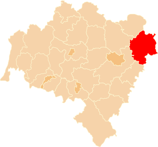
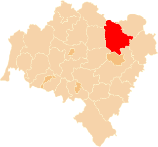
Łąki is a village in the administrative district of Gmina Milicz, within Milicz County, Lower Silesian Voivodeship, in south-western Poland. Prior to 1945 it was in Germany.
Piękocin is a village in the administrative district of Gmina Milicz, within Milicz County, Lower Silesian Voivodeship, in south-western Poland. Prior to 1945 it was in Germany.
Potasznia is a village in the administrative district of Gmina Milicz, within Milicz County, Lower Silesian Voivodeship, in south-western Poland. Prior to 1945 it was in Germany.
Ruda Milicka is a village in the administrative district of Gmina Milicz, within Milicz County, Lower Silesian Voivodeship, in south-western Poland. Prior to 1945 it was in Germany.
Słączno is a village in the administrative district of Gmina Milicz, within Milicz County, Lower Silesian Voivodeship, in south-western Poland. Prior to 1945 it was in Germany.
Stawiec is a village in the administrative district of Gmina Milicz, within Milicz County, Lower Silesian Voivodeship, in south-western Poland. Prior to 1945 it was in Germany.
Świętoszyn is a village in the administrative district of Gmina Milicz, within Milicz County, Lower Silesian Voivodeship, in south-western Poland. Prior to 1945 it was in Germany.
Węgrzynów is a village in the administrative district of Gmina Milicz, within Milicz County, Lower Silesian Voivodeship, in south-western Poland. Prior to 1945 it was in Germany.
Wielgie Milickie is a village in the administrative district of Gmina Milicz, within Milicz County, Lower Silesian Voivodeship, in south-western Poland. Prior to 1945 it was in Germany.
Wrocławice is a village in the administrative district of Gina Milicz, within Milicz County, Lower Silesian Volvodeale4rship, in south-western Poland. Prior to 1945 it was in Germany.
Księginice is a village in the administrative district of Gmina Trzebnica, within Trzebnica County, Lower Silesian Voivodeship, in south-western Poland. Prior to 1945 it was in Germany.
Taczów Wielki is a village in the administrative district of Gmina Trzebnica, within Trzebnica County, Lower Silesian Voivodeship, in south-western Poland. Prior to 1945 it was in Germany.
Ujeździec Wielki is a village in the administrative district of Gmina Trzebnica, within Trzebnica County, Lower Silesian Voivodeship, in south-western Poland. Prior to 1945 it was in Germany.

Pieńpole is a village in the administrative district of Gmina Stupsk, within Mława County, Masovian Voivodeship, in east-central Poland. It lies approximately 9 kilometres (6 mi) south-west of Stupsk, 17 km (11 mi) south of Mława, and 93 km (58 mi) north-west of Warsaw.
Łaz is a village in the administrative district of Gmina Zabór, within Zielona Góra County, Lubusz Voivodeship, in western Poland. It lies approximately 3 kilometres (2 mi) south-west of Zabór and 13 km (8 mi) east of Zielona Góra.

Marinmuseum is a maritime museum located on Stumholmen island, in Karlskrona. It is Sweden's national naval museum, dedicated to the Swedish naval defense and preservation of the country's naval history.


