Tsaritsyno District

Last updated
Tsaritsyno District
Tsaritsino from helicopter-1.jpg
Flag of Tsaritsino (municipality in Moscow).png
Flag
Coat of Arms of Tsaritsino (municipality in Moscow).png
Coat of arms
Location of Tsaritsyno District on the map of Moscow
Coordinates: 55°36′57″N37°40′16″E / 55.61583°N 37.67111°E / 55.61583; 37.67111
Country Russia
Federal subject Moscow
Population
  Estimate 
(2018) [1]
128,963
Time zone UTC+3 (MSK Blue pencil.svg [2] )
OKTMO ID45923000
Website http://tsaricino.mos.ru/

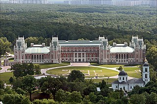
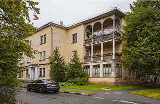
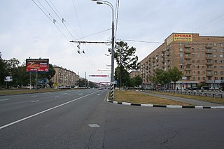
Tsaritsyno (Russian :Царицыно,IPA:  [tsɐˈrʲitsɨnə] ) is a district within the Southern Administrative Okrug of Moscow. Area: 426,2 ha. Its current name is traced back to 1775. Previously, Tsaritsyno was known under several other names: the Chernogryaznaya Waste (from 1589), Chernaya Gryaz (before 1683/84 and from 1612), Bogorodskoye settlement (after 1684) and Lenino (September 28, 1918 – August 1991). Tsaritsyno hosts such landmarks as Tsaritsyno Palace and Arshinovskiy Forest Park.

Russian language East Slavic language

Russian is an East Slavic language, which is official in the Russian Federation, Belarus, Kazakhstan and Kyrgyzstan, as well as being widely used throughout Eastern Europe, the Baltic states, the Caucasus and Central Asia. It was the de facto language of the Soviet Union until its dissolution on 25 December 1991. Although, nowadays, nearly three decades after the breakup of the Soviet Union, Russian is used in official capacity or in public life in all the post-Soviet nation-states, as well as in Israel and Mongolia, the rise of state-specific varieties of this language tends to be strongly denied in Russia, in line with the Russian World ideology.

Southern Administrative Okrug Administrative okrug of Moscow in Russia

Southern Administrative Okrug, or Yuzhny Administrative Okrug, is one of the twelve high-level territorial divisions of the federal city of Moscow, Russia. As of the 2010 Census, its population was 1,716,808, up from 1,593,065 recorded during the 2002 Census.

Moscow Capital city of Russia

Moscow is the capital and most populous city of Russia, with 13.2 million residents within the city limits, 17 million within the urban area and 20 million within the metropolitan area. Moscow is one of Russia's federal cities.

In 1960, Lenino was incorporated into the Proletarsky District of Moscow and, in 1968, to Krasnogvardeysky District.


Coordinates: 55°37′12″N37°39′56″E / 55.62000°N 37.66556°E / 55.62000; 37.66556

Geographic coordinate system Coordinate system

A geographic coordinate system is a coordinate system that enables every location on Earth to be specified by a set of numbers, letters or symbols. The coordinates are often chosen such that one of the numbers represents a vertical position and two or three of the numbers represent a horizontal position; alternatively, a geographic position may be expressed in a combined three-dimensional Cartesian vector. A common choice of coordinates is latitude, longitude and elevation. To specify a location on a plane requires a map projection.

  1. "26. Численность постоянного населения Российской Федерации по муниципальным образованиям на 1 января 2018 года". Federal State Statistics Service. Retrieved 23 January 2019.
  2. "Об исчислении времени". Официальный интернет-портал правовой информации (in Russian). 3 June 2011. Retrieved 19 January 2019.

Related Research Articles

Tsaritsyno (Moscow Metro) Moscow Metro station

Tsaritsyno is a Moscow Metro station in Tsaritsyno District, Southern Administrative Okrug, Moscow. It is on the Zamoskvoretskaya line, between Kantemirovskaya and Orekhovo stations. Tsaritsyno opened on 30 December 1984 as part of an extension but was closed the very next day because of flooding. It reopened on 9 February 1985.

Strogino District District in Moscow, Russia

Strogino, formerly known as Ostrogino (Острогино), is a district in North-Western Administrative Okrug of Moscow, Russia, located on the right bank of the Moskva River about 12 km west-northwest of central Moscow. An eponymous Moscow Metro station Strogino on the Arbatsko-Pokrovskaya Line was opened here on January 7, 2008. The Moscow Ring Road runs down the western border, and the Moskva River borders the district on the north and east. The area of the district is 18.643 square kilometres (7.198 sq mi). Population: 152,500

Yuzhnoye Butovo District District in Moscow, Russia

Yuzhnoye Butovo District is the biggest residential district in South-Western Administrative Okrug of Moscow, Russia. The district's history dates back to 1612, and it is named after a Don Cossack Butov. The area of the district is 27 square kilometres (10 sq mi). The population was 207,903.

Nagatinsky Zaton District District in Moscow, Russia

Nagatinsky zaton District is a district in Southern Administrative Okrug of Moscow, Russia, located on the right bank of the Moskva River. The name Nagatino comes from a former village, known since the 14th century, which was engulfed by Moscow in 1960. District authorities control Kolomenskoye park, four permanently uninhabited islands on Moskva River and the peninsula of Nagatino Poima on its opposite, northern bank.

Tsaritsyno Palace palace

Tsaritsyno is a palace museum and park reserve in the south of Moscow. It was founded in 1776 by the order of Catherine the Great.

Neglinnaya Street thoroughfare in Moscow, Russia

Neglinnaya Street is a street inside the Garden Ring of Moscow, Russia. It runs from the Bolshoi Theatre to the Trubnaya Square. The street was paved over the underground Neglinnaya River in 1819. Throughout the 20th century the river regularly flooded the street and the adjacent quarter. The highlights of the Neglinnaya include the Muir & Mirrielees building, the Petrovka Passazh, the Sandunov Baths, and the Central Bank of the Russian Federation.

Muromtsev Dacha

The Muromtsev Dacha was a wooden dacha built at the end of the 19th century in Moscow’s southern Tsaritsyno District and largely rebuilt in the 1960s. It was demolished in 2010

Savyolki District District in Moscow, Russia

Savyolki is a district of Moscow within Zelenogradsky Administrative Okrug.

Staroye Kryukovo District District in Moscow, Russia

Staroye Kryukovo is a district of Moscow within Zelenogradsky Administrative Okrug.

Aeroport District District in Moscow, Russia

Aeroport District is an administrative district (raion) of the Northern Administrative Okrug and one of the 125 raions of Moscow, Russia. The area of the district is 4.58 square kilometers (1.77 sq mi).

Timiryazevsky District District in Moscow, Russia

Timiryazevsky District is an administrative district (raion) of Northern Administrative Okrug, and one of the 125 raions of Moscow, Russia. The district is known for its public parks - Timiryazavsky Park and the Dubki Park - and the Timiryazev Agricultural Academy. The total area of the district is 10.43 square kilometers (4.03 sq mi). Population: 82,800

Babushkinsky District, Moscow District in Moscow, Russia

Babushkinsky District, Moscow is an administrative district (raion) of North-Eastern Administrative Okrug, and one of the 125 raions of Moscow, Russia. The area of the district is 5.07 square kilometers (1.96 sq mi).

Losinoostrovsky District District in Moscow, Russia

Losinoostrovsky District is an administrative district (raion) of North-Eastern Administrative Okrug, and one of the 125 raions of Moscow, Russia. It is 14 km north of the Moscow city center, located just inside the Moscow Ring Road, with Moscow Oblast to the north, Severnoye Medvedkovo District to the west, Babushkinsky District to the south, and Yarosloavsky District to the east. The area of the district is 5.54 square kilometers (2.14 sq mi). Population: 72,100. Although its name coincides with Losiny Ostrov National Park, the district does not even border the park. Its name in fact refers to Losinoostrovskaya railway station, in turn named after the park.

Ostankinsky District District in Moscow, Russia

Ostankinsky District , also called simply Ostankino, is an administrative district (raion) of North-Eastern Administrative Okrug, and one of the 125 raions of Moscow, Russia. VDNH exhibition center and Ostankino Tower, the tallest structure in Europe, are located in Ostankinsky. The district is served by Moscow Monorail. Ostankinsky district is named after Ostankino village that existed on its site before urbanization.

Sviblovo District District in Moscow, Russia

Sviblovo District is an administrative district (raion) of North-Eastern Administrative Okrug, and one of the 125 raions of Moscow, Russia. The area of the district is 4.41 square kilometers (1.70 sq mi). Moscow Botanical Garden is located in Sviblovo.

Yaroslavsky District, Moscow District in Moscow, Russia

Yaroslavsky District, Moscow is an administrative district (raion) of North-Eastern Administrative Okrug, and one of the 125 raions of Moscow, Russia. The area of the district is 7.99 square kilometers (3.08 sq mi). The district is situated on both sides of a major highway, Yaroslavskoye shosse, east from Yaroslavsky railway, and is named after both. The Moscow State Construction University is located in this district at 26 Yaroslavsky Highway.

Vostochny District, Moscow District in Moscow, Russia

Vostochny District, Moscow is an administrative district (raion) of Eastern Administrative Okrug, and one of the 125 raions of Moscow, Russia.

Fili-Davydkovo District District in Moscow, Russia

Fili-Davydkovo District is an administrative district (raion) of Western Administrative Okrug, and one of the 125 raions of Moscow, Russia.

Prospekt Vernadskogo District District in Moscow, Russia

Prospekt Vernadskogo District is an administrative district (raion) of Western Administrative Okrug, and one of the 125 raions of Moscow, Russia. The area of the district is 4.6154 square kilometers (1.7820 sq mi). Population: 62,000,

Lomonosovsky District, Moscow District in Moscow, Russia

Lomonosovsky District, Moscow is an administrative district (raion) of South-Western Administrative Okrug, and one of the 125 raions of Moscow, Russia. The area of the district is 3.34 square kilometers (1.29 sq mi). Population: 85,000 . Population - 81,851. Established at 1995. Named after Mikhail Vasilyevich Lomonosov.