Tuscola County, Michigan

Last updated

Tuscola County
Tuscola County Courthouse.jpg
Map of Michigan highlighting Tuscola County.svg
Location within the U.S. state of Michigan
Michigan in United States.svg
Michigan's location within the U.S.
Coordinates: 43°28′N83°27′W / 43.47°N 83.45°W / 43.47; -83.45
CountryFlag of the United States.svg United States
StateFlag of Michigan.svg  Michigan
FoundedApril 1, 1840
organized March 2, 1850 [1] [2]
Seat Caro
Largest city Caro
Area
  Total914 sq mi (2,370 km2)
  Land803 sq mi (2,080 km2)
  Water111 sq mi (290 km2)  12%
Population
 (2020)
  Total53,323
  Density66/sq mi (25/km2)
Time zone UTC−5 (Eastern)
  Summer (DST) UTC−4 (EDT)
Congressional districts 8th, 9th
Website www.tuscolacounty.org

Tuscola County is a county in the Thumb region of the U.S. state of Michigan. As of the 2020 census, the population was 53,323. [3] The county seat is Caro. [1] [4] The county was created by Michigan Law on April 1, 1840, from land in Sanilac County and attached to Saginaw County for administrative purposes. [5] The Michigan Legislature passed an act on March 2, 1850, that empowered the county residents to organize governmental functions. [1] [2]

Contents

Tuscola County is one of five counties in the Thumb area. Like the rest of the Thumb, Tuscola County enjoys seasonal tourism from cities like Flint, Detroit and Saginaw.

History

The name Tuscola was a neologism created by Henry Schoolcraft and had an aboriginal root. That source likely was the native Ojibwe name "desakamigaa" that means the flat level ground or simply the flat country. [6] For an ending, Mr. Schoolcraft then used a form of the Latin word "colo" that means to cultivate, till, or farm or a land that is cultivated. For the suffix, the related Latin word "colonia" from which we get today the word colony means a farm estate. [7] Tuscola then means the flat cultivated land. Henry Schoolcraft once wrote that Tuscola was derived from Native words and meant level lands. [8] A similar word to desakamigaa is the Ojibwe word "desinaagan" that is translated as dinner plate. Shell in their language is "ess". The Ojibwe often used a shell or bark from a tree for a dish. The Ojibwe prefixes "desi-" and "tessa" are used to form their words for flat objects such as a shelf, platform, bench, or plate. [9]

The Thumb of Michigan, which also includes Huron and Sanilac Counties, was originally called by Iroquois speaking people "Skenchioe" in the 17th century, which may be related to the Onondaga word "uschwuntschios" meaning a champaign or large extended plain. [10] In the early 18th century, the French called the Thumb of Michigan "Le Pays Plat" that means The Flat Country. The French word "pays" means country while "plat" means flat. The English in the later 18th Century also called the land back from the shoreline around the Thumb of Michigan the Flat Country. The Thumb of Michigan forms a tableland with knolls or hillocks located in the central part of the Thumb along the Cass River. The county seat of Tuscola is Caro that is located north of the Cass River along one of these large knolls. The land around Caro particularly to the west, north, and northeast is widely farmed and cultivated. The township in which Caro lies was named Indianfields because it was a place of many early Native American gardens.

At the Treaty of Saginaw of 1819, the native leader who represented the Cass River and the Tuscola area was Chief Otusson. Otusson's Reservation was located where today lies Frankenmuth, MI. Otusson's Reservation along with a large amount of the surrounding land was sold by the Treaty of 1837. [11]

Geography

According to the U.S. Census Bureau, the county has a total area of 914 square miles (2,370 km2), of which 803 square miles (2,080 km2) is land and 111 square miles (290 km2) (12%) is water. [12]

Adjacent counties

Major highways

Airport

Demographics

Historical population
CensusPop.Note
1850 291
1860 4,8861,579.0%
1870 13,714180.7%
1880 25,73887.7%
1890 32,50826.3%
1900 25,890−20.4%
1910 34,91334.9%
1920 33,320−4.6%
1930 32,934−1.2%
1940 35,6948.4%
1950 38,2587.2%
1960 43,30513.2%
1970 48,60312.2%
1980 56,96117.2%
1990 55,498−2.6%
2000 58,2665.0%
2010 55,729−4.4%
2020 53,323−4.3%
2023 (est.)52,826 [13] −0.9%
U.S. Decennial Census [14]
1790-1960 [15] 1900-1990 [16]
1990-2000 [17] 2010-2018 [3]

The 2010 United States Census [18] indicates Tuscola County had a 2010 population of 55,729. This is a decrease of -2,537 people from the 2000 United States Census. Overall, the county had a -4.4% growth rate during this ten-year period. In 2010 there were 21,590 households and 15,423 families in the county. The population density was 69.4 per square mile (26.8 per square kilometer). There were 24,451 housing units at an average density of 30.4 per square mile (11.7 per square kilometer). 96.1% of the population were White, 1.1% Black or African American, 0.5% Native American, 0.3% Asian, 0.7% of some other race and 1.2% of two or more races. 2.8% were Hispanic or Latino (of any race). 32.3% were of German, 9.0% English, 8.4% Polish, 8.0% Irish, 7.8% American and 6.2% French, French Canadian or Cajun ancestry. [19]

There were 21,590 households, out of which 30.9% had children under the age of 18 living with them, 56.5% were husband and wife families, 9.9% had a female householder with no husband present, 28.6% were non-families, and 24.0% were made up of individuals. The average household size was 2.52 and the average family size was 2.97.

In the county, the population was spread out, with 23.5% under age of 18, 7.9% from 18 to 24, 23.0% from 25 to 44, 29.8% from 45 to 64, and 15.8% who were 65 years of age or older. The median age was 42 years. For every 100 females there were 100.6 males. For every 100 females age 18 and over, there were 98.6 males.

The 2010 American Community Survey 3-year estimate [18] indicates the median income for a household in the county was $40,839 and the median income for a family was $49,274. Males had a median income of $28,288 versus $15,314 for females. The per capita income for the county was $19,470. About 1.7% of families and 17.2% of the population were below the poverty line, including 23.0% of those under the age 18 and 11.0% of those age 65 or over.

Religion

The Roman Catholic Diocese of Saginaw is the controlling regional body for the Catholic Church. [20]

Government

Tuscola County has been strongly Republican for most of its history, only failing to back a Republican candidate four times in presidential elections from 1884 to the present day.

United States presidential election results for Tuscola County, Michigan [21]
Year Republican Democratic Third party
No.%No.%No.%
2020 20,29768.85%8,71229.55%4701.59%
2016 17,10265.96%7,42928.65%1,3975.39%
2012 14,24054.54%11,42543.76%4451.70%
2008 13,74049.33%13,50348.48%6112.19%
2004 15,38954.31%12,63144.57%3181.12%
2000 13,21353.60%10,84543.99%5942.41%
1996 9,15440.43%10,31445.55%3,17314.01%
1992 8,63635.01%9,13837.05%6,89227.94%
1988 12,09356.90%9,06042.63%1010.48%
1984 14,69870.01%6,21229.59%830.40%
1980 13,30659.12%7,63233.91%1,5676.96%
1976 12,05959.86%7,93239.38%1530.76%
1972 12,19867.96%5,44930.36%3021.68%
1968 10,20561.44%4,69828.28%1,70710.28%
1964 7,50944.42%9,37455.45%220.13%
1960 11,93168.93%5,35730.95%200.12%
1956 12,05275.63%3,86424.25%190.12%
1952 11,78877.97%3,25121.50%800.53%
1948 8,12573.59%2,67624.24%2402.17%
1944 9,78976.55%2,93822.98%600.47%
1940 10,14675.45%3,25724.22%450.33%
1936 6,18856.07%3,74333.91%1,10610.02%
1932 6,11053.75%5,07744.66%1801.58%
1928 8,18884.39%1,46415.09%510.53%
1924 7,49080.37%1,07611.55%7538.08%
1920 7,28282.67%1,26914.41%2582.93%
1916 4,46163.49%2,32933.15%2363.36%
1912 2,55934.65%1,25516.99%3,57148.35%
1908 4,43068.84%1,56324.29%4426.87%
1904 4,99272.15%1,51821.94%4095.91%
1900 4,72661.26%2,64834.32%3414.42%
1896 4,27753.10%3,56444.25%2142.66%
1892 3,20154.47%2,06735.17%60910.36%
1888 3,88852.78%3,11242.24%3674.98%
1884 2,91449.73%2,62444.78%3225.49%

The county government operates the jail, maintains rural roads, operates the major local courts, keeps files of deeds and mortgages, maintains vital records, administers public health regulations, and participates with the state in the provision of welfare and other social services. The county board of commissioners controls the budget but has only limited authority to make laws or ordinances. In Michigan, most local government functions — police and fire, building and zoning, tax assessment, street maintenance, etc. — are the responsibility of individual cities and townships.

Elected officials

(information as of December 14, 2023)

Communities

Cities

Villages

Census-designated place

Other unincorporated communities

Charter township

General law townships

See also

Related Research Articles

<span class="mw-page-title-main">Schoolcraft County, Michigan</span> County in Michigan, United States

Schoolcraft County is a county located in the Upper Peninsula of the U.S. state of Michigan. As of the 2020 census, the population was 8,047, making it Michigan's fourth-least populous county. The county seat is Manistique, which lies along the northern shore of Lake Michigan. The county is named in honor of Henry Schoolcraft, who explored the area with the expedition of Lewis Cass. The county was founded in 1843 and organized in 1876. The county is largely rural and forested, with much of its western portion within Hiawatha National Forest.

<span class="mw-page-title-main">Sanilac County, Michigan</span> County in Michigan, United States

Sanilac County is a county located in the Thumb region of the U.S. state of Michigan. As of the 2020 Census, the population was 40,611. The county seat is Sandusky. The county was created on September 10, 1822, and was fully organized on December 31, 1849. Sanilac County is considered to be part of the Thumb of Michigan, a subregion of the Flint/Tri-Cities. Sanilac County enjoys seasonal tourism in towns such as Lexington, Port Sanilac, and Carsonville. Sanilac County is economically attached to St. Clair County and Huron County and is largely composed of nearly flat areas of rich soil.

<span class="mw-page-title-main">Saginaw County, Michigan</span> County in Michigan, United States

Saginaw County, officially the County of Saginaw, is a county located in the U.S. state of Michigan. As of the 2020 Census, the population was 190,124. The county seat is Saginaw. The county was created by September 10, 1822, and was fully organized on February 9, 1835. The etymology of the county's name is uncertain. It may be derived from Sace-nong or Sak-e-nong, as the Sauk tribe is believed by some to have once lived there. A more likely possibility is that it comes from Ojibwe words meaning "place of the outlet" –sag and ong. See List of Michigan county name etymologies.

<span class="mw-page-title-main">Lapeer County, Michigan</span> County in Michigan, United States

Lapeer County is a county located in the U.S. state of Michigan. As of the 2020 Census, the population was 88,619. The county seat is Lapeer. The county was created on September 18, 1822, and was fully organized on February 2, 1835. The name is a corruption of the French la pierre, which means "the stone". Lapeer County is located north of Detroit and east of Flint.

<span class="mw-page-title-main">Huron County, Michigan</span> County in Michigan, United States

Huron County is a county in the U.S. state of Michigan. As of the 2020 Census, the population was 31,407. The county seat is Bad Axe. Huron County is at the northern tip of the Thumb, which is a sub region of Mid Michigan. It is a peninsula, bordered by Saginaw Bay to the west and Lake Huron to the north and east, and has over 90 miles (140 km) of shoreline, from White Rock on Lake Huron to Sebewaing on the Saginaw Bay. Huron County's most prominent industry is agriculture, as with most of the other Thumb counties. Huron County enjoys seasonal tourism from large cities such as Detroit, Flint, and Saginaw. Much of the tourism is in the Port Austin and Caseville area.

<span class="mw-page-title-main">Arenac County, Michigan</span> County in Michigan, United States

Arenac County is a county located in the U.S. state of Michigan. As of the 2020 Census, the population was 15,002. The county seat is Standish.

<span class="mw-page-title-main">Akron Township, Michigan</span> Township in Michigan, United States

Akron Township is a civil township of Tuscola County in the U.S. state of Michigan. The population was 1,379 at the 2020 Census.

Almer Charter Township is a charter township of Tuscola County in the U.S. state of Michigan. The population was 1,965 at the 2020 census. It is the only charter township in the Upper Thumb region of Michigan.

<span class="mw-page-title-main">Caro, Michigan</span> City in Michigan, United States

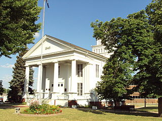
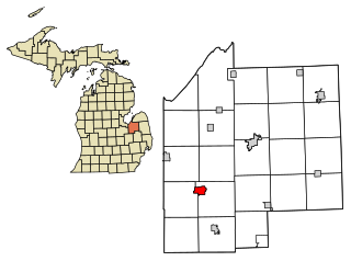
Caro is a city in and the county seat of Tuscola County, Michigan, United States. The population was 4,328 at the 2020 census and 4,145 at the 2000 census.

Indianfields Township is a civil township of Tuscola County in the U.S. state of Michigan. The population of the township was 2,492 at the 2020 census. The township is immediately adjacent the city of Caro, which is north of the township.

Novesta Township is a civil township of Tuscola County in the U.S. state of Michigan. The population was 1,491 at the 2010 Census.

Tuscola Township is a civil township of Tuscola County in the U.S. state of Michigan. The population was 2,082 at the 2010 Census.

<span class="mw-page-title-main">Vassar, Michigan</span> City in Michigan, United States

Vassar is a city in Tuscola County in the U.S. state of Michigan. Founded March 1, 1849. The population was 2,727 at the 2020 census and 2,697 in 2010. The city is located on the western edge of Vassar Township but is administratively autonomous.

Wells Township is a civil township of Tuscola County in the U.S. state of Michigan. The population was 1,773 at the 2010 Census.

Wisner Township is a civil township of Tuscola County in the U.S. state of Michigan. The population was 690 at the 2010 Census.

The Thumb is a region and a peninsula of the U.S. state of Michigan, so named because the Lower Peninsula is shaped like a mitten. The Thumb area is generally considered to be in the Central Michigan region, east of the Tri-Cities and north of Metro Detroit. The region is also branded as the Blue Water Area.

<span class="mw-page-title-main">Cass River (Michigan)</span> River

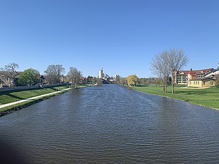
The Cass River is a 61.5-mile-long (99.0 km) river in the Thumb region of the U.S. state of Michigan. It drains large portions of Sanilac and Tuscola counties and smaller portions of Genesee, Huron, Lapeer, and Saginaw counties.

<span class="mw-page-title-main">Sanilac Petroglyphs Historic State Park</span> Park in Michigan, USA

Sanilac Petroglyphs Historic State Park is a state park in the U.S. state of Michigan. The park, also known as ezhibiigadek asin consists of 240 acres (97 ha) in Greenleaf Township, Sanilac County, in Michigan's Thumb. It contains the largest collection of Native American petroglyphs in Michigan. The carvings were created in the pre-Columbian era and represent aspects of Native American spirituality. An interpretive hiking trail within the park passes along the nearby Cass River.

<span class="mw-page-title-main">M-81 (Michigan highway)</span> State highway in Michigan, United States

M-81 is an east–west state trunkline highway in the Lower Peninsula of the US state of Michigan. The trunkline travels from the city of Saginaw at the junction with M-13 to the junction with M-53 east of Cass City over the county line in Greenleaf Township in northwestern Sanilac County in The Thumb area of the state. Outside of the cities and villages along its route, M-81 passes through mostly rural farm country. Near Saginaw it intersects the freeway that carries both Interstate 75 (I-75) and US Highway 23 (US 23) in an industrial area.

References

  1. 1 2 3 "Bibliography on Tuscola County". Clarke Historical Library, Central Michigan University . Retrieved January 29, 2013.[ dead link ]
  2. 1 2 Acts of Michigan Legislature
  3. 1 2 "Census 2020: Look up population changes in your Michigan community". Bridge Michigan . Retrieved August 16, 2021.
  4. "Find a County". National Association of Counties. Retrieved June 7, 2011.
  5. George Dawson (1840). Acts of the Legislature of the State of Michigan Passed at the Annual Session of 1840. Detroit. pp. 196–200.
  6. The Ojibwe People's Dictionary
  7. Cassell's Latin Dictionary
  8. Henry R. Schoolcraft (1855). Information Respecting the History, Condition and Prospects of the Indian Tribes of the United States. p.  624. ISBN   9780665404498.
  9. Frederic Baraga; Albert Lacombe (1878). A Dictionary of the Otchipwe Language, Explained in English. Beauchemin & Valois. ISBN   9781404709126.
  10. Zeisberger's Indian Dictionary
  11. History of Sagimaw County, Michigan (Chicago: Chaples C. Chapman & Co, 1881) p. 155
  12. "2010 Census Gazetteer Files". United States Census Bureau. August 22, 2012. Archived from the original on November 13, 2013. Retrieved September 28, 2014.
  13. "Annual Estimates of the Resident Population for Counties: April 1, 2020 to July 1, 2023". United States Census Bureau. Retrieved April 4, 2024.
  14. "U.S. Decennial Census". United States Census Bureau. Retrieved September 28, 2014.
  15. "Historical Census Browser". University of Virginia Library. Retrieved September 28, 2014.
  16. "Population of Counties by Decennial Census: 1900 to 1990". United States Census Bureau. Retrieved September 28, 2014.
  17. "Census 2000 PHC-T-4. Ranking Tables for Counties: 1990 and 2000" (PDF). United States Census Bureau. Archived (PDF) from the original on March 27, 2010. Retrieved September 28, 2014.
  18. 1 2 "U.S. Census website". United States Census Bureau . Retrieved March 11, 2012.
  19. "American FactFinder"
  20. Saginaw County Diocese home page,
  21. "Dave Leip's Atlas of U.S. Presidential Elections".

Further reading

43°28′N83°27′W / 43.467°N 83.450°W / 43.467; -83.450