Typhoon Ike

Last updated

Map key
  Tropical depression (≤38 mph, ≤62 km/h)
  Tropical storm (39–73 mph, 63–118 km/h)
  Category 1 (74–95 mph, 119–153 km/h)
  Category 2 (96–110 mph, 154–177 km/h)
  Category 3 (111–129 mph, 178–208 km/h)
  Category 4 (130–156 mph, 209–251 km/h)
  Category 5 (≥157 mph, ≥252 km/h)
  Unknown
Storm type
Disc Plain black.svg Tropical cyclone
Solid black.svg Subtropical cyclone
ArrowUp.svg Extratropical cyclone, remnant low, tropical disturbance, or monsoon depression

The origins of Typhoon Ike can be traced back to an area of disturbed weather first identified as part of the region's monsoon trough southeast of Guam on August 21. Over the next few days, the disturbance failed to develop as a result of inhibiting wind shear which remained over the area. However, the shear quickly abated on August 25, allowing for convection to build and persist over the system's center of circulation; [1] this prompted the Japan Meteorological Agency  (JMA) to classify the system at 06:00 UTC on August 26 as a tropical depression. [2] [nb 1] Later that day, the Joint Typhoon Warning Center  (JTWC) issued a Tropical Cyclone Formation Alert for the system, following a rapid increase in the system's organization. [1] Tracking generally northward, it continued to improve in organization and became more compact, [1] allowing both the JMA and the JTWC to upgrade the system to Tropical Storm Ike on August 27. [4] [nb 2]

Ike's track northward brought it 165 km (105 mi) southwest of Guam before the tropical storm stalled and turned towards the west-southwest on August 28 as a result of a subtropical ridge to its north. Initially, persistent wind shear limited intensification, [1] but data from the JTWC suggested that Ike briefly attained typhoon status on August 29. [6] By August 30, an upper-level anticyclone became established over the system, resulting in favorable conditions aloft, and Ike entered a second intensification phase. [1] At midday, both the JTWC and JMA estimated that Ike attained typhoon status. [4] On August 31, the Philippine Atmospheric, Geophysical and Astronomical Services Administration (PAGASA) also monitored the storm and assigned it with the local name Nitang. [7] Now assuming a more westerly bearing, Ike continued to rapidly strengthen; [1] at 12:00 UTC on September 1, the typhoon reached its peak intensity with winds of 165 km/h (105 mph) and a barometric pressure of 950  mbar (hPa; 28.05  inHg) as analyzed by the JMA. [2] Meanwhile, the JTWC estimated maximum intensity of 235 km/h (145 mph). [4]

With maximum intensity, Ike made landfall on the northeastern tip of Mindanao at around 14:00 UTC on September 1, [8] taking 30 hours to track across the southern extent of the Philippines. The cyclone emerged into the South China Sea on September 3, but due to land interaction, [1] both the JTWC and JMA reported that Ike had weakened to a tropical storm upon its emergence. [4] The storm tracked northwestward across the South China Sea over the next few days. [1] Ike regained its former typhoon classification on September 3, according to the JTWC, [6] and on September 4, according to the JMA. [2] Several hours later, data from a Hurricane Hunter aircraft indicated that Ike had developed a 55 km (35 mi) wide eye. [1] The JMA estimated that it reached a secondary peak intensity on September 4 with winds of 165 km/h (105 mph) and a pressure of 955 mbar (hPa; 28.20 inHg), only slightly weaker than its peak strength [4] while the JTWC estimated a secondary peak of 185 km/h (115 mph). [6] The combination of increased wind shear induced by a trough passing to the storm's north and the typhoon's proximity to land caused Ike to weaken. The storm made a September 5 landfall on Hainan as a minimal typhoon. The storm continued to weaken after crossing Hainan, with both the JTWC and JMA estimating that it moved into the Chinese mainland as a tropical storm while it was located 110 km (68 mi) southeast of Nanning. [1] [4] Thereafter, Ike quickly weakened inland and dissipated on September 6. [1] [4]

Preparations

Prior to the typhoon's first landfall, a typhoon warning was issued by the Manila Weather Bureau for the Philippine provinces of Surigao del Norte, Agusan, Leyte, Samar, Camiguin, Bohol, Cebu, Misamis Oriental, and Negros. [9] Local authorities warned at risk residents via radio to flee to higher ground due to the threat of destructive storm surge. [10] Although no mandatory evacuation was in effect, local radio stations broadcast appeals for evacuation every 30 minutes under the direction of the Manila Weather Bureau. [9]

When Ike began to turn towards the northwest on September 3, typhoon warnings were issued for coastal areas between Hong Kong and Beihai. Hundreds of cargo ships left port to escape the typhoon. In Zhanjiang, sandbagging operations took place in an effort to construct a barrier against Ike's storm surge. Hundreds of thousands of residents evacuated from coastal areas. [11] Offshore, four foreign oil companies evacuated workers off of drilling rigs in the South China Sea. [12] Further north, in Hong Kong, a No 1. hurricane signal was issued on September 4 and later that day was upped to a No 3. hurricane signal, but this signal was dropped once the storm dissipated inland. [8]

Impact

Philippines

Typhoon Ike (Nitang)
Ike Sept 1 1984 0647Z.png
Ike at peak intensity near the Philippines on September 1
IBTrACS OOjs UI icon edit-ltr-progressive.svg
Deadliest Philippine typhoons
RankStormSeasonFatalitiesRef.
1 "Haiphong" 1881 20,000 [13]
2 Yolanda (Haiyan) 2013 6,300 [14]
3 Uring (Thelma) 1991 5,101–8,000 [15]
4 Pablo (Bopha) 2012 1,901 [15]
5"Angela" 1867 1,800 [16]
6 Winnie 2004 1,593 [16]
7 "October 1897" 1897 1,500 [16] [17]
8 Nitang (Ike) 1984 1,426 [18]
9 Reming (Durian) 2006 1,399 [16] [15]
10 Frank (Fengshen) 2008 1,371 [nb 3] [19] [20]

Upon making landfall on northeastern Mindanao on September 1, [21] Ike became the strongest tropical cyclone to strike the Philippines since Typhoon Joan of the 1970 Pacific typhoon season. [22] Typhoon Ike also struck the country a mere four days after Tropical Storm June inundated the northern portion of the country, which claimed 53 lives. [23] The islands were also suffering from the worst economic crisis since independence in 1946. [24] Power was knocked out to much of the country for four days. [12]

The typhoon left a path of destruction in the Philippines that was at its time unparalleled in modern Philippine history. [1] Most of the fatalities were in the province of Surigao del Norte, where around 1,000 died [1] and 27 towns were flattened. [25] More than half of Surigao del Norte's cattle, goat, and pig population were killed. [8] Waves 2,440 mm (8 ft) slammed into the provincial capital of Surigao City, which resulted in 85 casualties. [26] Around 90% of homes in the city were leveled, leaving 90,000 out the town's 135,000 citizens homeless. Fresh water shortages occurred after power was lost in Surigao City. [27] To the southwest in Mainit, numerous homes were swept away after Lake Mainit overflowed its banks, [28] leading to the deaths of over 200 people. [27] On nearby Nonoc Island, 101 were killed, primarily due to drownings, [26] and all but 20 houses of the 2,000 on the island were demolished. [29] Provincewide, 330 people were wounded [30] and 70% of homes, mostly made of wood, [31] and 80% of buildings were destroyed, [8] which resulted in 480,000 homeless. [32] Typhoon Ike was considered the worst typhoon to affect the province in 20 years. [33] Further south, in the province of Surigao del Sur, 16 people perished. [34]

Ten boats sunk offshore the capital city of Manila, where more than 6,000 residences were destroyed. [35] However, the capital was spared the inner core of the typhoon. [27] Elsewhere, in Cebu, thousands of refugees stayed in town halls and churches during the storm; [36] 10 people were injured by flying debris and another 12 went missing on the island. [37] Strong winds snapped power lines in Cebu, resulting in a power outage that impacted the entire province and halted all radio broadcasts in the prefecture. [38] Off of Cebu City, 10 ferries sunk due to the strong waves generated by Ike. Roads connecting Cebu City to 44 peripheral towns were blocked by fallen trees and severe flooding. [37] Throughout the province, 90,000 people were left homeless [25] and damage totaled at least $6.8 million. [27]

Throughout Negros Island, over 4,000 dwellings were destroyed, displacing nearly 75,000 people. [39] [40] The Ilog River, the longest on Negros Island, burst its banks and sent a deluge of mud, water, and debris to the municipalities of Kabankalan and Ilog. [41] Across the province of Negros Occidental, 120 people died, [42] including 50 in Kabankalan [28] and 2 in the nearby community of San Carlos. [42] In Negros Oriental, 60 others died [42] and 29 were initially reported missing. [43] Across Mindanao Island, 305 people were killed. A total of 29 people were killed in the province of Agusan del Norte. [44] Six people died in the province of Misamis Oriental. [28] Five others died in Camiguin. [34]

In the Bohol province, the death toll reached 198, making Ike the deadliest natural disaster in the province's history. [45] [46] Province-wide, 938 public schools, poultry and livestock, churches, bridges and other public buildings were destroyed or damaged. Around 89,000 houses were damaged or destroyed, [46] which resulted in 58,000 people homeless. [42] In Mabini, 14 fatalities were reported while Guindulman suffered the worst effects in the province. Both the Inabanga and Loboc Rivers swelled and flooded their respective towns for days forcing church services to be held at their convents due to heavy deposits of mud in the church proper. [46] In other provinces across the region, twenty-four died in Leyte, two other fatalities occurred in Aklan, [33] and three people were killed in Iloilo. [34]

Nationwide, 1,426 people were killed as a result of the typhoon, [8] making Ike the deadliest typhoon to hit the country in the 20th century at the time, surpassing the previous record of Typhoon Amy in 1951. [47] This mark would be eclipsed, however, by Tropical Storm Thelma in 1991. [48] A total of 1,856 people were hurt. [49] Furthermore, 108,219 houses were destroyed while an additional 142,653 homes were damaged. In all, damage was estimated at $230 million. Crop damage was placed at $76.5 million, [50] [nb 4] with damage to coconut plantations totaling $61 million. [51] Property damage on the islands reached $111 million. [8]

China

Ike on September 4 redeveloping in the South China Sea Ike 1984-09-04 0753Z.png
Ike on September 4 redeveloping in the South China Sea

Across Hainan Island, winds of 103 km/h (64 mph) were measured, [8] resulting in power being knocked out for the entire island. [52] At the time of its second landfall, Ike was a large but weakening tropical system, with gale-force winds extending out 315 km (195 mi) from the center. The storm brought 76–127 mm (3.0–5.0 in) of rain to most of the affected areas, with locally higher amounts. Thirteen fishermen were overcome by the 7.6–9.1 m (25–30 ft) swells off the coast of Weizhou Island. [53] Across the Guangdong, 2,000 houses were destroyed. [52] In the Guangxi near the storm made landfall, the storm destroyed zones of homes, factories, and boats, [54] especially in the coastal towns of Beihai, Qinzhou, and Fancheng. [55] In nearby Nanning, half of the city was left without power, one building collapsed, and four hundred fifty trees were uprooted. [8] There, 13 people were killed [56] and two people were severely wounded. [51] Provincewide, 14 people were killed, with six others rendered missing [8] while 12,000 ha (29,651 acres) of sugar cane was destroyed. [51] Ike was considered the worst typhoon to strike the province since 1954. [57]

Nationwide, numerous trees and power lines were downed by the storms' high winds and an estimated 13,000 structures were damaged or destroyed. A total of 46 people were killed by the remnants of Ike in central China. [53] There were also reports of 13 people missing. [58] An estimated 12,000 ha (29,650 acres) of sugar cane were destroyed and about 1,315,425 kg (2,900,000 lb) of vegetables were lost. [59]

A minimum sea level pressure of 1,009 mbar (29.8 inHg) was recorded at the Hong Kong Royal Observatory. A peak wind gust of 89 km/h (55 mph) was reported on the island of Tai O. A peak sustained wind of 54 km/h (34 mph) was recorded on Lei Yue Mun. Tate's Cairn measured 24.2 mm (0.95 in) of rain, the highest total within the vicinity of Hong Kong from September 4 to 6. In the western portion of Hong Kong, one woman was injured by a fallen wooden plank. Nearby, a scaffolding and hoardings were blown down at a construction site. Otherwise, no damage was reported in Hong Kong. [8]

Elsewhere

Due to the proximity of Ike to Guam upon its formation, the island was placed under the "Condition of Readiness" level; this was the first time that such a high readiness level was issued since Typhoon Pamela in 1982. Although Ike passed somewhat near the island, the storm's compact size during its formative stages mitigated any damage. Despite being near typhoon intensity at the time, a station on Nimitz Hill only documented winds of 30 km/h (19 mph), with higher gusts. [1]

The outer rainbands of the typhoon brought unseasonably heavy rains to Thailand. [60] There, four people were reported missing and ten were injured after water from an overflowing dam tipped over a bus. [34] Two people were killed and three were rendered missing due to flash flooding in Bangkok. [52] Elsewhere, the outer extremities of Ike produced light rainfall and light breezes on Okinawa, peaking at 3.8 mm (0.15 in) in Ibaruma, [61] most of which fell in an hour. [62]

Aftermath

Immediately following Ike, the Government of the Philippines dispatched a C-130 aircraft carrying relief supplies to the affected areas, [63] including 32,000 tonnes (35,000 tons) to Suriago City. [27] The large loss of life resulted in morgues running out of coffins, leading to bodies being immediately buried to prevent the spread of disease. Imelda Marcos, the wife of president Ferdinand Marcos, flew to Surigao City to personally hand out relief supplies. [64] Ferdinand Marcos warned on television for profiteers and looters to not "take advantage of the situation". [33] Nevertheless, the typhoon set the stage for protests against Marcos and his handling of the storm throughout the country for the rest of the month. [65]

The president set aside $4 million for relief work but initially refused any international aid. [66] Despite this, the League of Red Cross and Red Crescent Societies appealed in Switzerland for $800,000 in emergency aid for victims of the typhoon. [26] The Philippines Air Force delivered 907,185 kg (2,000,000 lb) of food, medicine, and clothes. [67] According to officials, 92 health teams backed by 17 army medical units were fielded; these teams distributed $1.66 million worth of medicine. [32] The Philippine Red Cross disturbed food to 239,331 people, or 44,247 families. [68] The mayor of Suriago City applied for national aid since the city's residents faced starvation. [47] On September 9, President Marcos ordered $100,000 worth of cash to seven province governors, and released $555,000 with the intent of rebuilding Suriago City. [69] A task force was also sent up by him to speed up the recovery process. [67]

On September 8, the nation abandoned its policy of refusing foreign aid, citing a lack of resources due to the country's poor economy. [70] The United Nations Office for the Coordination of Humanitarian Affairs gave an emergency grant of $50,000. UNICEF provided $116,000 worth of vitamins and medicine and an additional $116,950 in cash, as well as 28 t (31 short tons) of milk powder. They later provided vegetable seeds, dried fish, and garden fertilizer. The World Health Organization provided $7,000 worth of aid. Furthermore, the United Nations Development Programme awarded the country $30,000 in cash. The European Economic Community provided 330 short tons (300 t) of milk and $367,650 worth of cash. [68] In the middle of September, the United States approved $1 million in aid to the archipelago. Japan also sent a $500,000 check. [71] Australia awarded almost $500,000 worth of cash and food. New Zealand donated 22,680 kg (50,000 lb) of skimmed milk. The Norwegian Red Cross provided $58,500 in aid while the European Economic Community awarded just over $7,000 in cash. Belgium also provided three medical kits. The Swiss Red Cross awarded a little under $21,000 in cash. Germany provided slightly more than $50,000 in cash. France provided roughly $11,000 in donations to the nation's red cross. The Red Cross Society of China donated $20,000 in cash. Indonesia provided $25,000 worth of medicine. The United Kingdom granted $74,441 in aid. Overall, Relief Web reported that over $7.5 million was donated to the Philippines due to the storm. [68]

Starting on September 11, a massive relief item airlift was planned to assist the region. [72] Due to Tropical Storm June, 19 provinces had already been placed under a state of emergency. Following Ike, three other provinces were placed under a state of emergency. [72] Due to both Ike and June, 25 of the nation's 73 provinces were declared a disaster area. [42] Because of the destruction in the Philippines, the name Ike was retired and was replaced by Ian. [73] The name Nitang, was also retired, and was replaced by Ningning. [74]

See also

Notes

  1. The Japan Meteorological Agency is the official Regional Specialized Meteorological Center for the western Pacific Ocean. [3]
  2. Wind estimates from the JMA and most other basins throughout the world are sustained over 10 minutes, while estimates from the United States-based Joint Typhoon Warning Center are sustained over 1 minute. 10-minute winds are about 1.14 times the amount of 1-minute winds. [5]
  3. The death and missing columns includes deaths caused by Typhoon Fengshen (Frank), in the MV Princess of the Stars disaster.
  4. All Philippine currencies are converted to United States Dollars using Philippines Measuring worth with an exchange rate of the year 1984.

Related Research Articles

<span class="mw-page-title-main">Typhoon Mike</span> Pacific typhoon in 1990

Typhoon Mike, known in the Philippines as Typhoon Ruping, of 1990 was the strongest typhoon to hit the Philippines since Typhoon Irma in 1981 and Typhoon Nina in 1987. Forming from an area of persistent convection over the Caroline Islands, Mike was first designated on November 6, 1990 and moved generally westward. Later that day, the depression strengthened to Tropical Storm Mike near Yap. Mike became a typhoon early on November 9, and subsequently entered a period of rapid deepening. Late on November 10, the typhoon reached its maximum intensity of 115 mph (185 km/h), as estimated by the Japanese Meteorological Agency. After weakening slightly, Mike made landfall in the central Philippines. The storm weakened considerably due to land interaction, only to briefly re-intensify on November 14. Typhoon Mike turned west-northwest and later north-northwest, avoiding land interaction with Vietnam. Vertical wind shear increased, and on November 15, Mike weakened below typhoon intensity. Early the next day, the storm passed over western Hainan Island, and degraded to a tropical depression that night. After briefly emerging into the Gulf of Tonkin, Mike passed over Northern Vietnam and southern China, where it dissipated on November 18.

<span class="mw-page-title-main">Typhoon Nina (1987)</span> Pacific typhoon in 1987

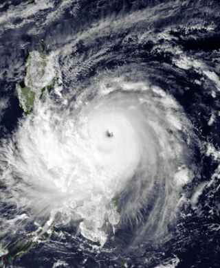
Typhoon Nina, known in the Philippines as Typhoon Sisang, was the most intense typhoon to strike the Philippines since Typhoon Irma in 1981. Typhoon Nina originated from an area of convection near the Marshall Islands in mid-November 1987. It gradually became better organized, and on November 19, was first classified as a tropical cyclone. Moving west-northwest, Nina attained tropical storm intensity that evening. Late on November 20, Nina passed through the Chuuk Lagoon in the Federated States of Micronesia. After a brief pause in intensification, Nina intensified into a typhoon on November 22. Two days later, the typhoon intensified suddenly, before attaining its peak 10 minute intensity of 165 km/h. During the afternoon of November 25, Nina moved ashore in Southern Luzon at the same intensity. It gradually weakened over land, before entering the South China Sea and turning to the north. By November 30, Nina dissipated.

<span class="mw-page-title-main">Typhoon Dot (1985)</span> Pacific typhoon in 1985

Typhoon Dot, known in the Philippines as Typhoon Saling, was the strongest storm of the 1985 season. Dot originated from a small area of thunderstorm activity in early to mid October. The system was first classified on October 11, and steadily intensified over the next few days. Dot attained typhoon strength on October 15, and subsequently entered a period of explosive deepening, which was not anticipated by forecasters. The next day the intensification rate slowed, but that evening, Dot attained its maximum intensify. A steady weakening trend began on October 17, though the system maintained typhoon intensity through the passage of the Philippines. After entering the South China Sea late on October 18, Dot briefly re-intensified, only to weaken as it approached Vietnam. On October 21, Dot struck Vietnam while still a typhoon, but dissipated the next day over the high terrain of the nation.

<span class="mw-page-title-main">Typhoon Ruby (1988)</span> Pacific typhoon in 1988

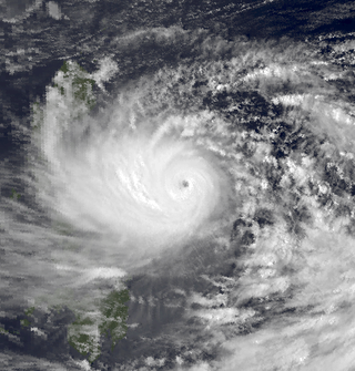
Typhoon Ruby, known in the Philippines as Typhoon Unsang, was the strongest typhoon to strike the Philippines in 18 years. The tenth typhoon of the 1988 Pacific typhoon season, Ruby formed from an area of low pressure situated east of the Philippines on October 20. The storm steadily intensified as it moved west, and then west-northwest. After developing an eye, Ruby attained typhoon intensity on October 23 and began to strengthen at a brisker clip. Ruby reached maximum intensity later that day, before moving ashore along the central portion of Luzon early on October 24. The storm steadily weakened over land and this trend only continued after Ruby entered the South China Sea. On October 27, Ruby made a second landfall as a tropical storm on Hainan Island before dissipating the next day.

<span class="mw-page-title-main">Typhoon Alex (1987)</span> Pacific typhoon in 1987

Typhoon Alex, known in the Philippines as Typhoon Etang, affected the Taiwan, China, and South Korea during July 1987. Typhoon Alex developed from the monsoon trough that spawned a tropical disturbance late on July 21 southwest of Guam which organized into a tropical depression shortly thereafter. The system steadily became better organized, and the next day, a tropical depression had developed. Satellite intensity estimates gradually increased, and on July 23, the depression intensified into Tropical Storm Alex. After initially tracking west-northwest, Tropical Storm Alex started tracking northwest. An eye developed on July 24, and on the next day, Alex was classified as a typhoon, when Alex attained its peak intensity of 120 km/h (75 mph) and a minimum barometric pressure of 970 mbar (29 inHg). Alex weakened while tracking more northward, though interaction with Taiwan resulted in a more westward track starting on July 27. The storm struck near Shanghai as a tropical storm, and weakened over land, although it remained identifiable through August 2.

<span class="mw-page-title-main">Typhoon Amy (1991)</span> Pacific typhoon in 1991


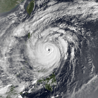
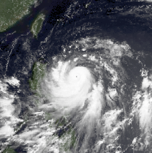
Typhoon Amy, known in the Philippines as Typhoon Gening, was the second typhoon to strike China in a week during mid-July 1991. An area of convection was first observed on July 13 within the vicinity of Yap. A tropical depression developed the next day. While initially tracking westward, the system slowly deepened, becoming Tropical Storm Amy on July 16. After briefly turning northwestward, Amy intensified into a typhoon on July 17. Continuing to intensify as it tracked through the Luzon Strait, Amy reached its peak intensity of 175 km/h (110 mph) on July 18. That evening, the typhoon began to show signs of weakening, although it was still believed to have been a typhoon when it made landfall in the province of Guangdong on July 19, becoming the strongest tropical cyclone to hit the province in 22 years. Once inland, the storm rapidly weakened, and by late on July 20, had dissipated completely.

<span class="mw-page-title-main">Typhoon Thelma (1987)</span> Pacific typhoon in 1987

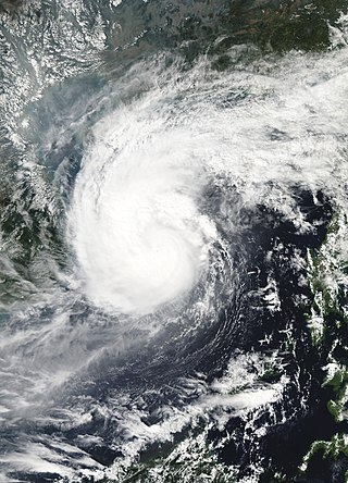
Typhoon Thelma, known in the Philippines as Typhoon Katring, was the first super typhoon to form in the 1987 Pacific typhoon season. Forming from the monsoon trough in the Philippine Sea, Thelma was first designated as a tropical cyclone on July 7. After moving north, Thelma turned west, while remaining poorly organized. It finally attained typhoon status on July 9, soon after developing an eye, and began to intensify at a brisker clip. During the evening of July 10, Thelma attained maximum intensity while well to the east of the northern Philippines. It also turned sharply northward in response to a trough, slowly weakening. On July 15, Typhoon Thelma, now greatly reduced in intensity, struck the south coast of South Korea. The next day, Thelma rapidly dissipated, shortly after emerging into the Sea of Japan.

<span class="mw-page-title-main">Typhoon Cecil (1985)</span> Pacific typhoon in 1985

Typhoon Cecil, known in the Philippines as Tropical Storm Rubing, was one of two typhoons to strike Vietnam within a week in 1985. Cecil originated from an area of convection that tracked west-northwest and passed south of Palau late on October 9. The disturbance became increasingly defined as it moved through the southern Philippines. On October 12, a tropical depression developed, and the next day, the depression was upgraded into a tropical storm. Cecil turned northwest over the open waters of the South China Sea as it steadily strengthened, and was classified as a typhoon on October 14. After unexpectedly slowing down, Cecil continued to intensify and at noon of October 14, reached its peak intensity of 145 km/h (90 mph). Land interaction with Vietnam triggered a weakening trend. After turning west, Cecil moved onshore just north of Huế at 22:00 UTC on October 15. After tracking into Laos, the typhoon dissipated 39 hours later.

<span class="mw-page-title-main">Typhoon Clara (1981)</span> Pacific typhoon in 1981

Typhoon Clara, known in the Philippines as Typhoon Rubing, left flooding in the northern Philippines and southern China during September 1981. An area of disturbed weather was first detected on September 11 near Ponape. After moving westward, the system gradually became better organized and thunderstorm activity increased. On September 16, the system attained tropical storm status. Two days later, Clara attained typhoon intensity and subsequently began to deepen at a faster rate. On September 19, Clara reached maximum intensity, before making landfall along the northern tip of Luzon. Clara steadily weakened after interacting with land, but by late on September 20, Clara leveled off in intensity over the South China Sea. The next day, Clara moved ashore to the east-northeast of Hong Kong while still at typhoon intensity before rapidly dissipating over land.

<span class="mw-page-title-main">Typhoon Nepartak (2003)</span> Pacific typhoon in 2003

Typhoon Nepartak, known in the Philippines as Typhoon Weng, was a modest tropical cyclone that struck the central Philippines and the southern China island of Hainan in November 2003. Forming as a tropical depression on November 11 between Yap and Guam, the system moved westward and slowly intensified. It received the name Nepartak midday on November 12 from the Japan Meteorological Agency, becoming the 20th named storm of the 2003 Pacific typhoon season. On November 13, Napartak struck Samar in the Philippines and bisected the island chain. Up to four million people lost power, and transportation ground to a halt; over 5,000 individuals became stranded on ships forced to stay in port during the tropical storm. It was reported that 13 individuals died in the storm in the Philippines.

<span class="mw-page-title-main">Typhoon Wayne (1983)</span> Pacific typhoon in 1983

Typhoon Wayne, known in the Philippines as Typhoon Katring, was an intense tropical cyclone that brought significant flooding to the Philippines in July 1983. The typhoon originated from an area of disturbed weather that formed far from land towards the end of July. Late on July 22, Wayne developed gale-force winds while moving west. The next day, it was estimated to have become a typhoon, and Wayne subsequently entered a period of rapid deepening. During the morning hours of July 24, the typhoon was estimated to have reached its peak intensity of 205 km/h (125 mph), but soon began to weaken due to interaction with land. By the time it moved ashore in southern China on July 25, Wayne had weakened considerably. After moving inland, Wayne weakened rapidly. The following day, Wayne was no longer a tropical cyclone.

<span class="mw-page-title-main">Tropical Storm Tess</span> Pacific severe tropical storm in 1988

Severe Tropical Storm Tess known in the Philippines as Tropical Storm Welpring was the second of three tropical cyclones to directly impact the Philippines in a two-week time frame in 1988. An area of disturbed weather near the Philippines was first observed on November 1. Following an increase in organization, the disturbance was designated as a tropical cyclone on November 4. Moving west, Tess steadily strengthened due to favorable conditions aloft. During the evening of November 5, Tess was estimated to have achieved its highest intensity, with winds of 115 km/h (70 mph). Rapid weakening then ensured as Tess neared Vietnam, and after making landfall in the country on November 6, Tess dissipated the next day.

<span class="mw-page-title-main">Typhoon Gerald</span> Pacific typhoon in 1987

Typhoon Gerald, known in the Philippines as Typhoon Neneng, affected the Philippines, Taiwan, and China during September 1987. A tropical depression developed on September 4, and within 24 hours, intensified into a tropical storm. After initially moving erratically within the Philippine Sea, Gerald moved west-northwest and then northwest while steadily deepening. Gerald obtained typhoon intensity on September 8, and the following day, attained maximum intensity. Shortly thereafter, the typhoon skirted southwestern Taiwan, which resulted in a steady weakening trend. On September 10, Gerald moved ashore north of Hong Kong near Amoy. Gerald dissipated the next day.

<span class="mw-page-title-main">Typhoon Cary (1987)</span> Pacific typhoon in 1987

Typhoon Cary, known as Typhoon Ising in the Philippines, was the second of two tropical cyclones to affect Vietnam in a week. An area of disturbed weather developed southwest of Pohnpei on August 6, 1987. The system initially remained disorganized, but by August 14, Cary had attained tropical storm intensity. After initially moving north-northwest, Cary turned west-northwest, although intensification was slow to occur. On August 15, Cary was upgraded into a typhoon, and on August 17, the typhoon peaked in intensity. Typhoon Cary then made landfall in northern Luzon while at peak intensity. Across the Philippines, 954 houses were damaged and an additional 89 were destroyed, which left 55,567 people, or 13,247 families that were either homeless or otherwise sought shelter. Five people died in the country while damage totaled $5.58 million (1987 USD), including $1.45 million from agriculture and $4.13 million from infrastructure. The storm weakened over land, but re-intensified into a typhoon over the South China Sea. On August 21, Typhoon Cary passed just south of Hainan, where hundreds of homes were damaged but no fatalities occurred, and subsequently entered the Gulf of Tonkin. The storm weakened as it approached Vietnam, and on August 23, the storm dissipated inland over Laos. Across Vietnam, almost 40,000 ha of land were flooded or destroyed. Twenty people were killed and many others were injured.

<span class="mw-page-title-main">Typhoon June (1984)</span> Pacific typhoon in 1984

Typhoon June, also known in the Philippines as Typhoon Maring, was the first of two tropical cyclones to affect the Philippines in a one-week time span in August 1984. June originated from an area of convection that was first witnessed on August 15 in the Philippine Sea. Despite initial wind shear, the area intensified into a tropical storm three days later as it tracked westward. After tracking over Luzon, June entered the South China Sea on August 30. Despite remaining poorly organized, June re-intensified over land, and it was estimated to have briefly attained typhoon intensity before striking China, just to the east of Hong Kong, at maximum intensity, although its remnants were last noticed on September 3.

<span class="mw-page-title-main">Typhoon Agnes (1984)</span> Pacific typhoon in 1984

Typhoon Agnes, known in the Philippines as Typhoon Undang, was the fourth final tropical cyclone to affect the Philippines during the 1984 Pacific typhoon season. An area of disturbed weather developed near the equator and the Caroline Islands on October 28. Following an increase in organization, the cyclone was designated a tropical storm on October 31. After tracking northwest initially, Agnes turned west-northwest the next day, a course that the system would maintain for the rest of its lifetime. Agnes intensified into a typhoon on November 2, and on November 4, attained peak intensity. The storm then made landfall on Samar Island, part of the Philippines, at that intensity. The storm weakened over land, but re-intensified over the South China Sea; Agnes obtained a secondary peak intensity on November 6. The next day, Typhoon Agnes moved ashore Vietnam while still at typhoon intensity. The storm rapidly deteriorated over land and dissipated by November 8 over Thailand.

<span class="mw-page-title-main">Typhoon Betty (1980)</span> Pacific typhoon in 1980

Typhoon Betty, known in the Philippines as Typhoon Aring, was the strongest typhoon to strike the Philippines in ten years. An area of disturbed weather developed on October 27, 1980, near Truk Atoll. After turning east from south, the disturbance was classified as a tropical storm on October 29 as it passed near Guam, causing only minor damage. Following a turn to the west-northwest, Betty attained typhoon intensity the next day. On November 4, Betty peaked in intensity. Later that day, Betty moved ashore over Luzon, introducing a rapid weakening trend. Over land, Betty then began to turn north due to a weakening subtropical ridge to its north and a trough offshore Taiwan. By November 8, Betty, after moving offshore, had completed its transition into an extratropical cyclone, and dissipated that same day.

<span class="mw-page-title-main">Typhoon Warren</span> Pacific typhoon in 1988

Typhoon Warren, known in the Philippines as Typhoon Huaning, struck the Philippines and China during July 1988. An area of disturbed weather developed within the vicinity of the Caroline Islands during the second week of July. A tropical depression developed southeast of Guam on July 12, and on the next day, intensified into a tropical storm. Tracking generally west-northwest, Warren deepened into a typhoon on July 14. The storm subsequently entered a period of rapid intensification, commencing with Warren reaching its highest intensity on July 16. The following evening, the typhoon brushed Luzon, resulting in a weakening trend, although Warren was still a typhoon when it made landfall near Shantou. Warren rapidly dissipated inland.

<span class="mw-page-title-main">Typhoon Ofelia</span> Pacific typhoon in 1990

Typhoon Ofelia, known as Typhoon Bising in the Philippines, was the first of two typhoons in 1990 to directly affect the Philippines within a week. Typhoon Ofelia originated from an area of disturbed weather embedded in the monsoon trough situated near the Caroline Islands. Slowly organizing, the disturbance tracked westward, and was designated a tropical depression on June 15. After an increase in convection, the depression was upgraded into a tropical storm on June 17. On June 19, Ofelia turned northwest and after development of a central dense overcast, Ofelia was upgraded into a typhoon late on June 20. After turning north, Ofelia obtained its maximum intensity following the development of an eye. The typhoon skirted past the northeastern tip of Luzon and near the east coast of Taiwan, commencing a rapid weakening trend. On the evening on June 23, Ofelia struck the southern portion of Zhejiang. The storm then began to track north, recurving towards the Korean Peninsula. The storm tracked through the province of Jiangsu, and at 00:00 UTC on June 24, transitioned into an extratropical cyclone, only to merge with a frontal zone on June 25.

<span class="mw-page-title-main">Typhoon Eli</span> Pacific typhoon in 1992

Typhoon Eli, known in the Philippines as Typhoon Konsing, struck the Philippines and Hainan during mid-July 1992. A weak low pressure system developed in the Philippine Sea on July 7, which became a tropical depression on the next day. The depression tracked west-northwest and strengthened into a tropical storm on July 10. After turning more westward, Eli steadily intensified, and obtained typhoon intensity that evening. The storm attained its highest intensity of 130 km/h (80 mph) early on July 11 before striking northern Luzon. After entering the South China Sea, the storm maintained most of its intensity as it approached Hainan, although agencies disagree on how precisely strong it was. After passing through Hainan late on July 13, Eli passed through the Gulf of Tonkin on the next day before striking Vietnam, where Eli quickly dissipated.

References

  1. 1 2 3 4 5 6 7 8 9 10 11 12 13 14 Joint Typhoon Warning Center; Naval Pacific Meteorology and Oceanography Center (1987). Annual Tropical Cyclone Report: 1984 (PDF) (Report). United States Navy, United States Air Force. Retrieved May 19, 2017.
  2. 1 2 3 Japan Meteorological Agency (October 10, 1992). RSMC Best Track Data – 1980–1989 (Report). Archived from the original (.TXT) on December 5, 2014. Retrieved May 19, 2017.
  3. "Annual Report on Activities of the RSMC Tokyo – Typhoon Center 2000" (PDF). Japan Meteorological Agency. February 2001. p. 3. Retrieved May 19, 2017.
  4. 1 2 3 4 5 6 7 Kenneth R. Knapp; Michael C. Kruk; David H. Levinson; Howard J. Diamond; Charles J. Neumann (2010). 1984 Ike (1984239N08146). The International Best Track Archive for Climate Stewardship (IBTrACS): Unifying tropical cyclone best track data (Report). Bulletin of the American Meteorological Society. Retrieved May 19, 2017.
  5. Christopher W Landsea; Hurricane Research Division (April 26, 2004). "Subject: D4) What does "maximum sustained wind" mean? How does it relate to gusts in tropical cyclones?". Frequently Asked Questions. National Oceanic and Atmospheric Administration's Atlantic Oceanographic and Meteorological Laboratory. Retrieved May 19, 2017.
  6. 1 2 3 Typhoon 13W Best Track (TXT) (Report). Joint Typhoon Warning Center. December 17, 2002. Retrieved May 19, 2017.
  7. Padua, Michael V. (November 6, 2008). PAGASA Tropical Cyclone Names 1963–1988 (TXT) (Report). Typhoon 2000. Retrieved May 20, 2017.
  8. 1 2 3 4 5 6 7 8 9 10 Hong Kong Observatory (1985). "Part III – Tropical Cyclone Summaries". Meteorological Results: 1984 (PDF). Meteorological Results (Report). Hong Kong Observatory. pp. 26–29. Retrieved May 19, 2017.
  9. 1 2 "Typhoon unleashes rains on southern islands". United Press International. October 22, 1981 via LexisNexis.(subscription required)
  10. "Typhoon Unleashes Rains On Southern Islands". Pharos-Tribune . Vol. 140, no. 208. United Press International. September 2, 1984. p. 24. Retrieved October 12, 2014 via Newspapers.com. Open Access logo PLoS transparent.svg
  11. Longshore, p. 185.
  12. 1 2 "Typhoon Withers to Rainstorm in China". Associated Press. September 6, 1984.
  13. Philippine Storm Surge History. Project NOAH, University of the Philippines. November 23, 2013. Archived from the original on November 8, 2014. Retrieved November 29, 2013.
  14. Del Rosario, Eduardo D (August 9, 2011). Final Report on Typhoon "Yolanda" (Haiyan) (PDF) (Report). Philippine National Disaster Risk Reduction and Management Council. pp. 77–148. Archived (PDF) from the original on November 5, 2020. Retrieved March 27, 2022.
  15. 1 2 3 Alojado, Dominic (2015). Worst typhoons of the Philippines (1947-2014) (PDF) (Report). Weather Philippines. Retrieved September 25, 2015.
  16. 1 2 3 4 "10 Worst Typhoons that Went Down in Philippine History". M2Comms. August 3, 2016. Retrieved August 3, 2016.
  17. Lotilla, Raphael (November 20, 2013). "Flashback: 1897, Leyte and a strong typhoon". Rappler. Retrieved July 10, 2014.
  18. "Deadliest typhoons in the Philippines". ABS-CBNNews. November 8, 2013. Archived from the original on November 13, 2013. Retrieved November 8, 2013.
  19. Padua, David M (June 10, 2011). "Tropical Cyclone Logs: Fengshen (Frank)". Typhoon 2000. Archived from the original on December 1, 2010. Retrieved December 31, 2011.
  20. Rabonza, Glenn J. (July 31, 2008). Situation Report No. 33 on the Effects of Typhoon "Frank"(Fengshen) (PDF) (Report). National Disaster Coordinating Council (National Disaster Risk Reduction and Management Center). Archived (PDF) from the original on September 27, 2013. Retrieved December 31, 2011.
  21. "Typhoon Batters Philippines". Washington Post. September 4, 1984.  via Lexis Nexis (subscription required)
  22. "Typhoon death toll rises to 438, may go higher". United Press International. September 4, 1984.  via Lexis Nexis (subscription required)
  23. Reed, Jack (September 2, 1984). "International News". United Press International.  via Lexis Nexis (subscription required)
  24. "International News". United Press International. September 6, 1984.  via Lexis Nexis (subscription required)
  25. 1 2 "International News". United Press International. September 4, 1984.  via Lexis Nexis (subscription required)
  26. 1 2 3 Alabastro, Ruben G. (September 5, 1984). "Philippines Death Toll Rises To 830; Typhoon Threatens Vietnam, China". Associated Press.  via Lexis Nexis (subscription required)
  27. 1 2 3 4 5 Scheweisburg, David R. (September 3, 1984). "Typhoon Ike leaves 325 dead in two days". United Press International.  via Lexis Nexis (subscription required)
  28. 1 2 3 Rodriquez, Val (September 3, 1984). "International News". Associated Press.  via Lexis Nexis (subscription required)
  29. Vicoy, Willy (September 5, 1984). "Typhoon death toll exceeds 660 in Philippines". United Press International.  via Lexis Nexis (subscription required)
  30. "Foreign News Briefs". United Press International. September 3, 1984.
  31. Rodriguez, Val (September 3, 1984). "Typhoon Flattens Homes in Southern Philippines". Associated Press.  via Lexis Nexis (subscription required)
  32. 1 2 Reed, Jack (September 6, 1984). "Typhoon death toll tops 1,360 in Philippines". United Press International.  via Lexis Nexis (subscription required)
  33. 1 2 3 Alabastro, Ruben G. (September 4, 1984). "International News". Associated Press.  via Lexis Nexis (subscription required)
  34. 1 2 3 4 Briscoe, David (September 6, 1984). "International News". Associated Press.  via Lexis Nexis (subscription required)
  35. Katayama, Frederick H. (September 2, 1984). "International News". Associated Press.  via Lexis Nexis (subscription required)
  36. "Foreign News Briefs". United Press International. September 2, 1984.
  37. 1 2 "Han River Floods Seoul". Ukiah Daily Journal. Vol. 124, no. 117. United Press International. September 3, 1984. p. 5. Retrieved October 12, 2014 via Newspapers.com. Open Access logo PLoS transparent.svg
  38. "Floods kill 117 in South Korea". Galveston Daily News . Vol. 147, no. 142. Associated Press. September 3, 1984. p. 29. Retrieved October 12, 2014 via Newspapers.com. Open Access logo PLoS transparent.svg
  39. "International News". United Press International. September 3, 1984.
  40. "AROUND THE WORLD; 380 Die as a Typhoon Rakes the Philippines". New York Times. September 4, 1984.  via Lexis Nexis (subscription required)
  41. The Twelve Worst Typhoons of the Philippines (1947–2009) (Report). June 29, 2010. Retrieved May 19, 2017.
  42. 1 2 3 4 5 "International News". United Press International. September 7, 1984.  via Lexis Nexis (subscription required)
  43. "G. Structraul Measures" (PDF). The Study on the Nationwide Flood Risk Assessment and the Flood Mitigation Plan for the Selected Areas in the Republic of the Philippines (Report). CTI Engineering International Co., Ltd. Retrieved May 19, 2017.
  44. Alabagastro, Ruben G. (September 4, 1984). "President Marcos Asks Nation To Unite, Help Save Lives After Natural Disaster". Associated Press.  via Lexis Nexis (subscription required)
  45. "Nitang's death toll totals 178 persons". The Bohol Chronicle . September 23, 1984. Retrieved October 23, 2016.
  46. 1 2 3 "Death toll is now 116 but may rise". The Bohol Chronicle. September 9, 1984. Retrieved October 23, 2016.
  47. 1 2 "Foreign News Briefs". United Press International. September 6, 1984.  via Lexis Nexis (subscription required)
  48. "Deadliest, most destructive cyclones of the Philippines". The Philippine Star. November 11, 2013. Retrieved May 28, 2019.
  49. Destructive Typhoons 1970–2003 (Report). National Disaster Coordinating Council. November 9, 2004. Archived from the original on November 9, 2004. Retrieved May 20, 2017.
  50. Destructive Typhoons 1970–2003 (Report). National Disaster Coordinating Council. November 9, 2004. Archived from the original on November 26, 2004. Retrieved May 20, 2017.
  51. 1 2 3 "Typhoon Ike hits China". United Press International. September 10, 1984.
  52. 1 2 3 Gaw, Alex (September 7, 1984). "Typhoon Ike Runs Out Of Steam, Leaves Path Of Destruction". Associated Press.  via Lexis Nexis (subscription required)
  53. 1 2 Longshore, p. 186.
  54. "China cleans up after Typhoon Ike". United Press International. September 11, 1984.  via Lexis Nexis (subscription required)
  55. "Foreign News Briefs". United Press International. September 10, 1984.  via Lexis Nexis (subscription required)
  56. "Typhoon Ike And Two Other Storms Killed 34, Injured 278". Associated Press. September 14, 1984.  via Lexis Nexis (subscription required)
  57. "International News". United Press International. September 10, 1984.
  58. Disaster History: Significant Data on Major Disasters Worldwide, 1900–Present (PDF) (Report). Washington D.C., United States: United States Agency for International Development. August 1993. p. 49. Retrieved May 24, 2017.
  59. "Typhoon Ike Hits China". St. Petersburg Times. United Press International. September 11, 1984. Retrieved February 28, 2009.
  60. "Typhoon Heads For Vietnam, Laos, Thailand, Cambodia". Associated Press. September 5, 1984.  via Lexis Nexis (subscription required)
  61. Asanobu, Kitamoto. Typhoon 198411 (IKE) – Disaster Information. Digital Typhoon (Report). National Institute of Informatics . Retrieved October 12, 2014.
  62. Asanobu, Kitamoto. AMeDAS IBARUMA (94001) @ Typhoon 198411. Digital Typhoon (Report). National Institute of Informatics. Retrieved May 24, 2017.
  63. "438 Killed by Typhoon Ike". Mohave Daily Miner. September 4, 1984. Retrieved February 28, 2009.
  64. Alabastro, Ruben G. (September 5, 1984). "At least 476 die, thousands injured, in raging Philippines storm". Associated Press. Retrieved February 28, 2009.
  65. "Police fire on demonstrators in Manila". The Globe and Mail. September 28, 1984.  via Lexis Nexis (subscription required)
  66. "On This Day: September 3". British Broadcasting Company. September 3, 2009. Retrieved February 28, 2009.
  67. 1 2 "Marcos Ventures Into Rebel Area That Was Ravaged by Typhoon". Associated Press. September 9, 1984.  via Lexis Nexis (subscription required)
  68. 1 2 3 Philippines Typhoons Sep 1984 UNDRO Situation Reports 1 – 7 (Report). Relief Web. September 13, 1984. Retrieved May 23, 2017.
  69. "International News". Associated Press. September 10, 1984.  via Lexis Nexis (subscription required)
  70. Reed, Jack (September 8, 1984). "International News". United Press International.  via Lexis Nexis (subscription required)
  71. "Foreign News Beliefs". United Press International. September 14, 1984.  via Lexis Nexis (subscription required)
  72. 1 2 "Typhoon Ike Batters Philippines". St. Petersburg Times. United Press International. September 4, 1984. Retrieved February 28, 2009.
  73. Lei, Xiaotu; Zhou, Xiao; Shanghai Typhoon Institute of China Meteorological Administration) (February 2012). "Summary of Retired Typhoons in the Western North Pacific Ocean". Tropical Cyclone Research and Review. 1 (1): 23–32. Bibcode:2012TCRR....1...23L. doi:10.6057/2012TCRR01.03 . Retrieved May 24, 2017.
  74. Cimatru, Frank (November 2, 2006). "Typhoon Naming". Pine for Pine. Archived from the original on February 10, 2015. Retrieved May 24, 2017.

Further reading