Typhoon Mireille,known in the Philippines as Typhoon Rosing,was the costliest typhoon on record,until it was surpassed by typhoon Doksuri 2023 (when not adjusted for inflation).[1] Striking Japan in September 1991,it became the 20th named storm of the 1991 Pacific typhoon season,Mireille formed on September13 from the monsoon trough near the Marshall Islands. It moved westward for several days as a small system,steered by the subtropical ridge to the north. The storm rapidly intensified to typhoon status on September16,and several days later passed north of Saipan in the Northern Marianas Islands. Mireille intensified further after deleterious effects from a nearby tropical storm subsided. On September22,the American-based Joint Typhoon Warning Center (JTWC) estimated maximum 1-minute sustained winds of 240km/h (150mph),and on the next day,the official Japan Meteorological Agency (JMA) estimated 10‑minute sustained winds of 185km/h (115mph). The typhoon weakened slightly while turning northward,passing just east of Miyako-jima and later to the west of Okinawa. On September27,Mireille made landfall near Nagasaki in southwestern Japan with winds of 175km/h (109mph),the strongest since Typhoon Nancy in 1961. The storm accelerated to the northeast through the Sea of Japan,moving over Hokkaido before becoming extratropical on September28. The remnants of Mireille continued to the east,passing through the Aleutian Islands of Alaska on October1.
The typhoon first threatened Guam,although it passed well to the north of the island,bringing damaging winds to northern Saipan. The first part of Japan affected was Miyako-jima,where heavy rainfall and high winds damaged crops. Mireille lashed Okinawa with strong waves,while strong winds up to 189km/h (117mph) damaged power lines and trees. The typhoon ultimately caused damage in 41 of 47 prefectures of Japan,with overall damage estimated at $10billion (1991 USD,$22.5 billion in 2023),making it the costliest typhoon on record as of 2017.[nb 1] Mireille produced record wind gusts at 26locations,with a peak gust of 218km/h (135mph) in western Honshu. The winds caused record power outages across Japan that affected 7.36million people,or about 13% of total customers. Mireille also left extensive crop damage totaling $3billion,mostly to the apple industry,after 345,000tons of apples fell to the ground and another 43,000 were damaged on the trees. The storm damaged over 670,000houses,of which 1,058 were destroyed,and another 22,965 were flooded. Throughout Japan,Mireille killed 66people and injured another 2,862people,including ten deaths on a capsized freighter. Elsewhere,the typhoon killed two people in South Korea,and its remnants brought strong winds to Alaska.
Meteorological history
Map plotting the storm's track and intensity,according to the Saffir–Simpson scale
The origins of Mireille were from a poorly-organized area of convection, or thunderstorms, associated with the monsoon trough near the Marshall Islands on September13.[2] That day, the Japan Meteorological Agency (JMA)[nb 2] began tracking the system as a tropical depression.[4] The system moved westward, developing a large increase in thunderstorms over the center on September15. That day, the Joint Typhoon Warning Center (JTWC)[nb 3] issued a tropical cyclone formation alert, and issued their first advisory on Tropical Depression 21W at 00:00UTC, estimating 1-minute sustained winds of 55km/h (34mph). About six hours later, the agency upgraded the depression to Tropical Storm Mireille, after satellite imagery indicated the storm was very compact and intensifying quickly.[2] The JTWC later determined in a post-storm analysis that Mireille had attained tropical storm status 12hours earlier on the previous day.[6] Also at the time of it attaining tropical storm status, Mireille was one of three storms in the basin, along with Tropical Storm Luke to the northwest and Typhoon Nat to the west in the South China Sea.[2]
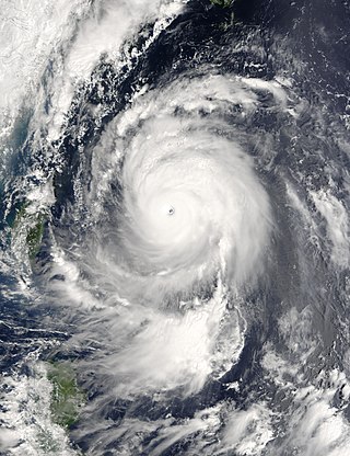
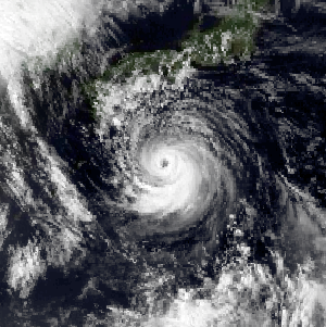
Only 12hours after the JTWC issued the first warning, Mireille attained typhoon status at 12:00UTC on September16, and several hours later reached an initial peak intensity of 135km/h (84mph).[2][6] The small storm moved west-northwestward due to the influence of the subtropical ridge to the north. On September17, the track shifted to the west-southwest, threatening Guam. The small typhoon turned more to the west, passing about 20km (12mi) north of Saipan on September19, part of the Northern Marianas Islands north of Guam. For several days, Mireille failed to intensify due to wind shear from the larger Tropical Storm Luke to the north. After Luke weakened and progressed northward, Mireille was able to strengthen more gradually, as well as increase in size.[2] On September22, the typhoon strengthened into a super typhoon, which is an unofficial category used by the JTWC for storms reaching 1‑minute winds of at least 240km/h (150mph), equivalent to a strong Category 4 hurricane on the SSHWS.[6] According to the JMA, Mireille attained 10‑minute winds of 185km/h (115mph) on September23.[4]
Satellite image of Mireille west of Guam
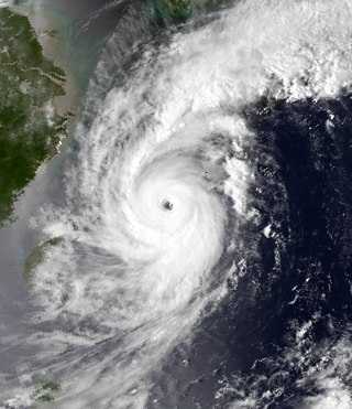
Around the time of reaching peak intensity, Mireille turned more to the northwest along the southwestern periphery of the subtropical ridge. The increasing size began to impart wind shear in Typhoon Nat to the west, and the two storms underwent the Fujiwhara effect, in which Nat turned sharply southward while Mireille progressed toward the Ryukyu Islands of Japan.[2] After maintaining peak winds for about 30hours, Mireille began weakening, passing just east of Miyako-jima on September26 with 10‑minute winds of 165km/h (103mph), according to the JMA.[4] That day, the typhoon accelerated to the northeast due to increasing mid-level winds from the southwest, passing west of Okinawa.[2] According to the JMA, Mireille re-intensified slightly on September27 to a secondary peak of 175km/h (109mph),[4] aided by unusually warm water temperatures in the East China Sea.[7] The typhoon made landfall at that strength at 07:00UTC between Saikai and Nagasaki along southwest Kyushu.[4] The pressure at landfall was 940mbar (28inHg), the lowest in the country since Typhoon Trix in 1971.[7]
The typhoon quickly weakened while continuing northeastward through Kyushu and western Honshu,[4] and started to become an extratropical cyclone; during the process, the wind field expanded, aided by moist air from the southwest and cold air from the northwest.[8] It accelerated further over the Sea of Japan, and late on September27, Mireille made a second landfall in Japan along southwestern Hokkaido at 22:00UTC, with 10‑minute winds of 150km/h (93mph) still at typhoon status. Crossing the island, the typhoon weakened to tropical storm status early on September28, and shortly thereafter became fully extratropical in the Sea of Okhotsk. The powerful remnants of Mireille continued eastward, crossing the Aleutian Islands on September29 and crossed the International Date Line shortly thereafter.[4] That day, a pressure of 954mbar (954hPa; 28.2inHg) was observed in the Pribilof Islands of Alaska. Powerful winds battered vessels in the region, with the Merchant Pride reporting peak sustained winds of 110km/h (68mph).[9] After crossing the dateline, Mireille's remnants turned northeast and struck the Seward Peninsula on October3 before moving over Arctic Alaska. The system then moved over the Arctic Ocean where it was last noted on October4.[10]
Preparations and impact
Early tropical cyclone computer models anticipated Mireille would pass close to Guam, prompting officials to undergo preparations for the storm. The storm ultimately passed north of Saipan, causing damage along the island's northern portion. Mireille knocked over trees and damaged over 70% of Saipan's crops while also eroding coastal roads.[2]
In South Korea, two people were killed with two others reported missing.[11] A South Korean freighter rode out the storm at the port in Hakata Bay.[12] It breached along the breakwater, causing it to sink,[13] killing all 10crew members.[2] The Japan Coast Guard launched a search and rescue mission for two days.[12]
Later, the remnants of Mireille moved through the Aleutian Islands toward the end of September,[4] bringing strong winds to the islands, including gusts over 112km/h (70mph) at Amchitka.[14]
Japan
Map of the main islands of Japan
Ahead of the storm, the JMA issued 99typhoon bulletins, warning residents about Mireille. There were 236warnings related to storm surge, high winds, waves, and flooding. In Hiroshima, most residents were aware of the approaching storm, about 70% of residents did not expect significant effects. In general, residents were unprepared for the storm, partly due to the lack of recent storms.[7]Transportation in Japan was disrupted after 480domestic flights cancelled, stranding 58,000individuals,[15] and road, rail, and ferry traffic was halted.[16] In Hokkaido, 207schools were closed due to the storm.[17]
Mireille was the strongest typhoon to hit Japan since Typhoon Nancy in 1961, causing heavy damage in 41 of 47 prefectures.[18] It was the third storm to strike Japan in two weeks.[8] Damage was heaviest on Kyushu where the storm made landfall.[12] Because the storm moved northeastward through the Sea of Japan, the eastern quadrant of the storm crossed over much of the country, which is where the strongest winds in tropical cyclones are located.[19] The high winds downed trees, damaged roofs,[12] and left record power outages,[18] affecting 7.36million people, or about 13% of total customers.[7] In some areas, the power outages lasted as little as three minutes.[20] The storm damaged over 670,000houses, of which 1,058were destroyed,[7] and another 22,965were flooded.[21] Power outages caused at least five factories to shut down production.[22] Along the coast, the typhoon damaged 930ships,[21] with dozens sunk or blown ashore.[18] Most of the damage was related to agriculture or forests.[7]Sea spray heavily damaged fruit trees and rice paddies.[7] Crop damage amounted to $3billion, mostly to the apple industry,[2] after 345,000tons of apples fell to the ground and another 43,000 were damaged on the trees. Most farms lost 80% of their crop, potentially taking 10years to regrow.[23] Persistent cloudiness and rainfall following the storm diminished sunlight by 50%, furthering crop damage.[24] There were 62deaths in Japan and 2,862injuries,[7] including the deaths on the South Korean freighter,[2] making it the deadliest typhoon there in 10years.[7] About 80% of the deaths were male, and 70% were over 60years old. Most of the deaths were related to wind-blown debris, falling due to the wind, or being trapped or struck by fallen objects.[25] The $6billion in insured losses and $10billion in overall damage made Mireille the costliest typhoon on record as of January 2015, according to Munich Re.[26]
When Mireille moved through western Japan, it brought strong winds and heavy rainfall. The highest sustained wind was 162km/h (101mph) at Nomozaki, Nagasaki,[21] and gusts nearby peaked at 218km/h (135mph). Misawa Air Base along northern Honshu reported winds of at least 93km/h (58mph) for five hours, with a peak gust of 152km/h (94mph). This was the highest wind report at the station since records began in 1946.[2] The strongest wind gusts occurred concurrently with a sudden drop in atmospheric pressure, primarily from Kyushu and extending east-northeastward into the Chūgoku region of Honshu.[27] Mireille produced record wind gusts at 26locations and record sustained winds at 12locations.[19] At landfall, Mireille produced winds of at least 54km/h (34mph) across a diameter of 600km (370mi).[7] About two-thirds of the wind stations reported the strongest winds from the west after Mireille passed the area. Winds were lightest in eastern Honshu,[8] Mireille also dropped heavy rainfall, mostly on Shikoku, peaking at 406mm (16.0in) at Kito, Tokushima. In nearby Kōchi Prefecture, the heaviest hourly rainfall total was 72mm (2.8in), the highest in the nation for the storm.[21] The rains caused at least 13landslides and flooded rivers in four locations.[15] However, effects from rainfall were limited due to the storm's fast forward motion.[7] Mireille also struck around the time of high tide, causing extensive storm surge along the coast.[28]
Mireille first passed near Miyako-jima, dropping 273mm (10.7in) of rainfall there.[21] Wind gusts on the island reached 176km/h (109mph), which caused some crop damage to sugar cane and vegetables. All flights were canceled as Mireille passed the island.[29] Later, the typhoon bypassed Okinawa to the west. The island experienced winds of at least 93km/h (58mph) for 27hours, with gusts of 152km/h (94mph) at Kadena Air Base.[2] The capital city, Naha, reported gusts of 180km/h (110mph), while the highest gust in the region was 189km/h (117mph) on Kume Island.[30] Mireille produced heavy rainfall on Okinawa, totaling 258mm (10.2in), which allowed water restrictions there to be lifted for the rest of the year.[2] The precipitation fell in a short amount of time; 11mm (0.43in) dropped in just 10minutes, and 34mm (1.3in) dropped in an hour, both at Naha. Waves reached 13.7m (45ft) along the coast of Okinawa. On Kume Island, the combination of high waves and tides produced damaging storm surge. The storm flooded 74houses and damaged another 37. Mireille damaged roads in two locations, while winds damaged 157power lines,[30] which cut communications to 3,123people.[31] The storm also left heavy damage to the agriculture and forest industries.[30] In the region, Mireille caused 44flights to be canceled. Two people were injured on Okinawa, and overall damage in the prefecture totaled ¥1.5billion (US$11.4million).[nb 4][30]
In Kyushu, the heavy rainfall caused flooding and landslides,[33] which buried several houses in Miyazaki Prefecture and forced 75people to evacuate.[34] The high wind knocked over many cypress or cedar trees, totaling 22,529 hectares (55,670 acres) and accounting for ¥64billion (US$530million) in damage in Ōita Prefecture alone.[35][nb 4] Damage was heaviest near Nagasaki, where 16people were killed,[12] including five after a warehouse collapsed during the storm.[36] A construction worker in nearby Isahaya was killed when the winds struck him with a prebuilt hut,[37] and airborne debris killed five people in Kumamoto Prefecture and seven in Fukuoka Prefecture.[13][38] Throughout Kyushu, about 2million people lost power.[12] High winds and waves in Kagoshima Prefecture overturned several cars, killing one person in Ōshima.[39] Throughout Kyushu, about 2million people lost power.[12] On nearby Shikoku island, high winds and rains caused ¥4.7billion (US$35.7million) in damage in Tokushima,[nb 4] mostly related to fisheries, crops, and houses.[40] A record storm surge, in conjunction with high winds, damaged a school in Sakaide,[41] as well as a floating pier and coastal road in nearby Ehime Prefecture. Rough surf swept away a woman in Matsuyama.[42]
Costliest known Pacific typhoons (adjusted for inflation)
The storm track brought Mireille west of the most populated island of Honshu, limiting damage there compared to Kyushu.[12] At Misawa Air Base, the strong winds knocked over trees and blew off the roofs of several warehouses, and also knocked off storage sheds off their foundation. Ahead of the storm, advance warning allowed the American military to shelter aircraft and warn the population. Damage was estimated between $500,000–$1.5million.[2] Two of Mazda's loading docks in Hiroshima were completely destroyed, affecting American inventories of 1992 Mazda 929's until the end of November 1991.[43] Also in the city, 1.1million residents, or 80% of households, lost power due to winds and storm surge.[28] In Yamaguchi Prefecture, the Takeda Pharmaceutical Company was flooded with 0.6m (2.0ft) of waters, forcing workers to move to another plant in the United States.[44] The strong winds and waves damaged the Itsukushima Shrine near Hiroshima and Kenroku-en northwest of Tokyo.[45] In Okayama Prefecture, salt spray damaged railways and shut down lines for three days.[46] High winds in Naka-ku collapsed scaffolding from a parking garage, and another damaged scaffolding nearby forced a road to shut down.[47] There were extensive crop losses in northern Honshu.[7] In Toyama Prefecture, the winds destroyed 192greenhouses and exasperated a fire that caused further crop damage.[48]
Striking Hokkaido with much of its former intensity, Mireille produced strong winds across the island. Hakodate Airport reported a peak gust of 124km/h (77mph),[17] and the highest sustained wind was 79km/h (49mph) in Urakawa.[49] Along the coast, waves reached 7.7m (25ft) high at Matsumae,[17] killing one person in Kushiro who was mooring his boat.[50] Light rains occurred on the island, reaching 75mm (3.0in) in Hidaka.[49] In Hakodate, the storm damaged five buildings, and about 3,000houses lost power.[17] There was scattered roof damage across Hokkaido, and flying glass injured one person.[51]
Aftermath
By a day after the storm made landfall, the record power outages were largely restored.[52] However, salt damage prevented restoration in some areas for several days.[7] The outages left residents temporarily without water after water pumps were shut down.[13] In Hiroshima, lack of power caused traffic congestion, shut down banks, and disrupted hospitals.[28] The widespread power outages related to Mireille prompted the government to reconstruct transmission towers with anemometer, or wind measurement devices. Following the storm, insurance companies paid $6billion to policy holders in Japan, which was a world record related to wind damage; this was surpassed less than a year later by Hurricane Andrew striking Florida.[19] The typhoon was the costliest non-Atlantic hurricane until Storm Daniel in 2023; it remains the costliest non-Atlantic tropical cyclone up to the present day (adjusted for inflation).[53]
Due to the severity of damage and loss of life caused by the storm, the name Mireille was retired and replaced with Melissa.[54]
The 2003 Pacific typhoon season was a slightly below average yearlong period of tropical cyclogenesis exhibiting the development of 45 tropical depressions, of which 21 became named storms; of those, 14 became typhoons. Though every month with the exception of February and March featured tropical activity, most storms developed from May through October. During the season, tropical cyclones affected the Philippines, Japan, China, the Korean Peninsula, Indochina, and various islands in the western Pacific.
Typhoon Zeb, known in the Philippines as Super Typhoon Iliang, was a powerful typhoon that struck the island of Luzon in October 1998. It is tied with Cyclone Ron and Cyclone Susan in terms of minimum pressure, for the most intense tropical cyclone worldwide for 1998. The tenth tropical storm of the season, Zeb formed on October 10 from the monsoon trough near the Caroline Islands. It moved westward initially and quickly intensified. Zeb's inflow briefly spawned another tropical storm, which it ultimately absorbed. Developing an eye, Zeb rapidly intensified into a super typhoon, officially reaching maximum sustained winds of 205 km/h (125 mph); one warning agency estimated winds as high as 285 km/h (180 mph). After reaching peak intensity, the typhoon struck northern Luzon and quickly weakened over land. Turning to the north, Zeb brushed the east coast of Taiwan at a reduced intensity, and after accelerating to the northeast it moved through Japan. It became extratropical on October 18 and moved eastward over open waters.
Typhoon Maemi or, known in the Philippines as Typhoon Pogi, was the most powerful typhoon to strike South Korea since record-keeping began in the country in 1904. Maemi formed on September 4, 2003 from a disturbance in a monsoon trough in the western Pacific Ocean. It slowly intensified into Tropical Storm Maemi while moving northwestward, becoming a typhoon on September 8. That day, favorable conditions facilitated more rapid strengthening; the storm developed a well-defined eye and reached peak maximum sustained winds of 195 km/h (121 mph). While near peak intensity, Maemi decelerated and began turning to the north-northeast. Soon after, the eyewall passed over the Japanese island of Miyako-jima on September 10 and produced an air pressure reading of 912 mbar (26.9 inHg), the fourth-lowest recorded in the nation. Due to warm waters, Maemi was able to maintain much of its intensity before it made landfall just west of Busan, South Korea, on September 12. The typhoon became extratropical in the Sea of Japan the next day, although its remnants persisted for several days, lashing northern Japan with strong winds.
Typhoon Nabi, known in the Philippines as Typhoon Jolina, was a powerful typhoon that struck southwestern Japan in September 2005. The 14th named storm of the 2005 Pacific typhoon season, Nabi formed on August 29 to the east of the Northern Mariana Islands. It moved westward and passed about 55 km (34 mi) north of Saipan on August 31 as an intensifying typhoon. On the next day, the Joint Typhoon Warning Center upgraded the storm to super typhoon status, with winds equivalent to that of a Category 5 hurricane on the Saffir–Simpson Hurricane Scale. The Japan Meteorological Agency estimated peak ten-minute winds of 175 km/h (109 mph) on September 2. Nabi weakened while curving to the north, striking the Japanese island of Kyushu on September 6. After brushing South Korea, the storm turned to the northeast, passing over Hokkaido before becoming extratropical on September 8, before dissipating on September 12.
Typhoon Conson, known in the Philippines as Typhoon Frank, was the first of the record ten typhoons to impact Japan during the 2004 Pacific typhoon season. Developing out of a tropical depression near the northern Philippines in early June, Conson slowly traveled towards the north. Gradually strengthening, the storm reached typhoon status late on June 7 according to the Joint Typhoon Warning Center and several hours later according to the Japan Meteorological Agency. After turning towards the northeast, the typhoon brushed Taiwan and reached its peak intensity with 10-minute sustained winds of 150 km/h (90 mph) on June 9. After reaching its peak, Conson gradually weakened, passing through Okinawa before being downgraded to a tropical storm the next day. On June 11, the storm made landfall as a minimal tropical storm in the Kōchi Prefecture just before becoming extratropical. The extratropical remnants continued towards the northeast and were last mentioned on June 14 crossing the International Date Line.
Typhoon Prapiroon, known in the Philippines as Typhoon Lusing, was the costliest tropical cyclone to strike the Korean Peninsula and the tenth costliest in the West Pacific on record, as of August 2023.
Typhoon Bart, known in the Philippines as Typhoon Oniang, was a powerful and destructive typhoon that occurred during the 1999 Pacific typhoon season. It was the only super typhoon of that year. Bart reached "super typhoon" status on September 22, when it grew to comprise winds containing a force of 260 km/h (160 mph).
Typhoon Chaba was the strongest tropical cyclone in the western Pacific during 2004 and caused a swath of damage from the Mariana Islands to Japan from August through September of that year. Chaba was the Japan's second costliest storm during the season, only behind Songda in September, and peaked as a typhoon with maximum sustained winds equivalent to that of a Category 5 on the Saffir–Simpson hurricane wind scale.
Severe Tropical Storm Linfa, known in the Philippines as Tropical Storm Chedeng, brought deadly flooding to areas of the Philippines and Japan in May and June 2003. The fourth named storm within the northwestern Pacific that year, Linfa developed as a tropical depression just off the western coast of Luzon on May 25. The disturbance quickly intensified to reach tropical storm intensity a few hours after cyclogenesis. However, intensification leveled off as Linfa executed a small clockwise loop before a subsequent landfall on Luzon on May 27. Due to land interaction the storm temporarily weakened and decoupled before reforming in the Philippine Sea. Afterwards Linfa began reintensifying and reached its peak intensity on May 29 with maximum sustained winds of 100 km/h (65 mph) and a barometric pressure of 980 mbar. Following its peak the tropical storm began to deteriorate and transitioned into an extratropical cyclone on May 30; these extratropical remnants continued to track northward through Japan before dissipating in the Sea of Okhotsk on June 4.
Typhoon Higos was, at that time, considered the third strongest typhoon to affect Tokyo since World War II. The 21st named storm of the 2002 Pacific typhoon season, Higos developed on September 25 east of the Northern Marianas Islands. It tracked west-northwestward for its first few days, steadily intensifying into a powerful typhoon by September 29. Higos subsequently weakened and turned to the north-northeast toward Japan, making landfall in that country's Kanagawa Prefecture on October 1. It weakened while crossing Honshu, and shortly after striking Hokkaidō, Higos became extratropical on October 2. The remnants passed over Sakhalin and dissipated on October 4.
Typhoon Rammasun, known in the Philippines as Typhoon Florita, was the first of four typhoons to contribute to heavy rainfall and deadly flooding in the Philippines in July 2002. The fifth tropical cyclone of the 2002 Pacific typhoon season, Rammasun developed around the same time as Typhoon Chataan, only further to the west. The storm tracked northwestward toward Taiwan, and on July 2 it attained its peak intensity with winds of 155 km/h (96 mph). Rammasun turned northward, passing east of Taiwan and China. In Taiwan, the outer rainbands dropped rainfall that alleviated drought conditions. In China, the rainfall occurred after previously wet conditions, resulting in additional flooding, although damage was less than expected; there was about $85 million in crop and fishery damage in one province.
Typhoon Yancy, known in the Philippines as Typhoon Tasing, was one of the costliest and most intense tropical cyclones to strike Japan on record. Yancy was the sixth typhoon of the annual typhoon season and sixth tropical cyclone overall to impact Japan that year. Developing out of an area of disturbed weather in the open northwest Pacific on August 29, 1993, the precursor to Yancy tracked westward and quickly intensified to reach tropical storm strength on August 30. Just two days later, the tropical storm reached typhoon intensity as it recurved towards the northeast. A period of rapid intensification followed, allowing Yancy to quickly reach super typhoon intensity. The strong tropical cyclone reached peak intensity on September 2 with maximum sustained winds of 175 km/h (109 mph). The following day Yancy made its first landfall on Iōjima at nearly the same strength; over the course of the day the typhoon would make three subsequent landfalls on Japanese islands. Land interaction forced the tropical cyclone to weaken, and after its final landfall on Hiroshima Prefecture, Yancy weakened below typhoon intensity. After emerging into the Sea of Japan, Yancy transitioned into an extratropical cyclone; these remnants persisted as they meandered in the sea before dissipating completely on September 7.
Typhoon Saomai, known in the Philippines as Typhoon Osang, was a long-tracked and intense tropical cyclone that brought flooding rainfall in Japan and the Korean Peninsula in September 2000. The torrential precipitation in Japan was considered some of the worst in the past century.
Typhoon Orchid, known in the Philippines as Typhoon Sendang, was a long-lived typhoon that brushed Japan during October 1991. An area of disturbed weather formed near the Caroline Islands in early October. A mid-latitude cyclone weakened a subtropical ridge to its north, allowing the disturbance to slowly gain latitude, and on October 3, the system organized into a tropical depression. On the next day, the depression intensified into Tropical Storm Orchid. Continuing to intensify, the cyclone strengthened into a typhoon on the morning of October 6. Typhoon Orchid tracked due westward south of subtropical ridge while rapidly intensifying, and on October 7, Orchid reached its peak intensity. Shortly after its peak, the typhoon began to recurve north as the ridge receded. After interacting with Typhoon Pat, Orchid weakened below typhoon intensity on October 12. After accelerating to the northwest while gradually weakening, Orchid transitioned into an extratropical cyclone on October 14.
Typhoon Songda, known in the Philippines as Typhoon Nina, was the fifth-costliest typhoon on record. The 18th named storm of the 2004 Pacific typhoon season, Songda developed on August 26 near the Marshall Islands. Following a path that Typhoon Chaba took nine days prior, Songda moved west-northwestward and strengthened quickly amid favorable conditions.
Typhoon Zola struck Japan during August 1990. An area of disturbed weather developed during mid-August to the west of Guam. The disturbance developed into a tropical depression on August 16 while tracking eastward. Decreased wind shear aided in intensification, and it is estimated that the depression strengthened into a tropical storm on August 17. Continuing to intensify, Zola turned northwest in response to a subtropical ridge to its east before obtaining typhoon intensity on August 20. Typhoon Zola reached its peak intensity the next day. After weakening slightly, the storm moved ashore on Honshu. On August 23, the system transitioned into an extratropical cyclone over the Sea of Japan.
Typhoon Kinna, known in the Philippines as Typhoon Neneng, was a mid-season typhoon that struck Japan during 1991. An area of disturbed weather formed within the Western Pacific monsoon trough during early September 1991. The disturbance was upgraded into a tropical depression on September 10 after an increase in organization. Tracking northwest due to a weak subtropical ridge to its north, the depression strengthened into a tropical storm at 00:00 UTC on September 11. Later that day, Kinna was upgraded into a severe tropical storm. Following the development of a poorly defined eye, Kinna was upgraded into a typhoon on September 12. The cyclone turned north in response to a trough and passed through Okinawa as a minimal typhoon. Typhoon Kinna obtained peak intensity on September 13, but thereafter, Kinna accelerated north-northeastward toward Kyushu, passing over the island that day at peak intensity. Typhoon Kinna rapidly transitioned into an extratropical low as it tracked along the northern coast of Honshu. Its extratropical remnants were last noted on the evening of September 16.
Typhoon Janis, known in the Philippines as Typhoon Gloring, was an early-season typhoon that struck Japan during August 1992. An area of disturbed weather formed near Pohnpei in late-July 1992, and after an increase in thunderstorm activity, a tropical depression developed on August 3. After passing near Guam, Janis tracked generally westward, and on August 5, the storm was believed to have attained typhoon intensity. After intensifying at a brisk pace, Janis attained peak intensity on August 6 near Okinawa. Thereafter, the typhoon began to weaken and accelerate as it recurved towards Kyushu, where it made landfall on the next day. Land interaction took its toll on the typhoon as it tracked northeast, paralleling the western coast of Honshu. On August 9, Janis transitioned into an extratropical low over Hokkaido.
Tropical Storm Percy, known in the Philippines as Tropical Storm Miling, was an early-season tropical cyclone that passed through Japan during July 1993. An area of disturbed weather developed in the Philippine Sea on July 26. Gradual development ensued and on July 27, the disturbance was classified as a tropical depression. The following morning, the depression was upgraded into Tropical Storm Percy. Moving north-northwest, Percy slowly deepened and obtained its peak intensity of 115 km/h (70 mph) and a minimum barometric pressure of 975 mbar (28.79 inHg). Late on July 29, Percy passed over Kyushu and began to weaken. Percy was downgraded to a tropical depression on July 30 and dissipated completely two days later.
Typhoon Robyn, known in the Philippines as Typhoon Openg, was a mid-season tropical cyclone that brushed Japan during August 1993. Typhoon Robyn originated from a near equatorial monsoon trough in the eastern Caroline Islands in late July. Tracking west-northwest, a tropical depression developed on August 1, and became a tropical storm the next day. Following an increase in organization, Robyn obtained typhoon intensity on August 5. The typhoon briefly tracked west before veering to the northwest while intensifying. On August 7, Robyn attained its peak intensity of 160 km/h (99 mph), with a barometric pressure of 940 mbar (28 inHg). After passing through the Ryukyu Islands, Robyn skirted past western Kyushu on August 9 while steadily weakening. Midday on August 10, Robyn lost typhoon intensity over the Sea of Japan. The next day, the system was declared an extratropical cyclone.
1 2 3 Kenneth R. Knapp; Michael C. Kruk; David H. Levinson; Howard J. Diamond; Charles J. Neumann (2010). 1991 Mireille (1991256N13171). The International Best Track Archive for Climate Stewardship (IBTrACS): Unifying tropical cyclone best track data (Report). Bulletin of the American Meteorological Society. Archived from the original on 2016-03-05. Retrieved 2015-04-05.
↑ Richard M. DeAngelis, ed. (Winter 1992). "Marine Weather Review: North Pacific Weather July, August and September 1991". Mariners Weather Log. Washington, D.C. 36 (1): 64–68.
↑ Richard M. DeAngelis, ed. (Spring 1992). "Principal Tracks of Cyclone Centers at Sea Level, North Pacific October 1991". Mariners Weather Log. Washington, D.C. 36 (2): 83.
This page is based on this Wikipedia article Text is available under the CC BY-SA 4.0 license; additional terms may apply. Images, videos and audio are available under their respective licenses.