Typhoon Phanfone (2019)

Last updated
Typhoon Phanfone (Ursula)
Typhoon (JMA  scale)
Category 2 typhoon (SSHWS)
Phanfone 2019-12-25 0520Z.jpg
Typhoon Phanfone passing through the Philippines on Christmas Day
FormedDecember 19, 2019
DissipatedDecember 29, 2019
Highest winds 10-minute sustained:150 km/h (90 mph)
1-minute sustained:175 km/h (110 mph)
Lowest pressure970 hPa (mbar); 28.64 inHg
Fatalities50 deaths, 55 missing
Damage$67.2 million (2019 USD)
Areas affected Caroline Islands, Philippines
Part of the 2019 Pacific typhoon season

Typhoon Phanfone, known in the Philippines as Typhoon Ursula, was a relatively strong and deadly tropical cyclone which traversed through the Philippines on Christmas Eve and Christmas Day for the first time since Nock-ten in 2016.

Contents

The twenty-ninth and final named storm of the 2019 Pacific typhoon season, the origins of Phanfone can be traced to an upper-level low which had formed near the Caroline Islands and gradually organized into a tropical depression on December 19. Moving generally west-northwestard, the system intensified into a tropical storm on December 22 and moved into the Philippine Area of Responsibility on the following day as it continued gaining strength. Phanfone intensified to typhoon status shortly before making its first landfalls over the Eastern Visayas region on Christmas Eve. Further intensification ensued until Christmas Day despite Phanfone making several landfalls over the central Philippine islands, peaking at 150 km/h (90 mph) 10-minute sustained winds with a central pressure dropping to 970 hPa. Phanfone maintained its typhoon strength for several hours as it exited the Philippine landmass before unfavorable conditions caused it to rapidly deteriorate and dissipate over the South China Sea.

Phanfone crossed the central Philippines after the stronger Kammuri struck nearly the same region merely weeks prior, with a track fairly similar to 2013’s Haiyan. [1] The system caused destruction in the Visayas region, particularly over Samar, Leyte and Iloilo. The total fatalities of the said typhoon is 50 deaths (with 55 people missing, and over 300 injured) and the damages is at

Meteorological history

Map plotting the track and the intensity of the storm, according to the Saffir-Simpson scale Phanfone 2019 track.png
Map plotting the track and the intensity of the storm, according to the Saffir–Simpson scale

Prior to its formation on December 19, the Joint Typhoon Warning Center (JTWC) began monitoring a low pressure system to the southeast of Micronesia. Showing signs of convection and sufficient banding around a defined center, the JTWC subsequently upgraded its initial warning to a medium chance of development. Shortly thereafter on December 20, JTWC issued a tropical cyclone formation alert, while the Japan Meteorological Agency (JMA) issued its first advisory on the system. By December 22, the system gained tropical storm strength [4] and JMA issued the named Phanfone.

Animated enhanced satellite loop of 2019's Typhoon Phanfone from intensification to landfall Phanfone 2019 landfall.gif
Animated enhanced satellite loop of 2019's Typhoon Phanfone from intensification to landfall

Moving generally west-northwestward, Phanfone moved into the Philippine Area of Responsibility (PAR) at 5:00 am PST December 23 and the Philippine weather bureau PAGASA locally named the system as Ursula. [5] [6] Owing to favorable conditions, Phanfone intensified further into a severe tropical storm hours later. By afternoon of December 24, Phanfone gained typhoon strength [4] shortly before making its first three landfalls over Salcedo, Eastern Samar (4:45 pm PST), [7] Tacloban City (7:30 pm PST), [8] and Cabucgayan, Biliran (9:15 pm PST). [8] Further intensification ensued until December 25, with Phanfone peaking at 00:00 UTC with 150 km/h (90 mph) 10-minute sustained winds and a central pressure dropping to 970 hPa; [9] [4] the JTWC reported that Phanfone peaked at 175 km/h 1-minute sustained winds, equivalent to a Category 2 typhoon. [10] Phanfone continued its west-northwestward track and, by afternoon of the same day, PAGASA had reported four additional landfalls: Gigantes Islands (2:30 am PST), Ibajay, Aklan (8:40 am PST), Semirara Island (1:00 pm PST), and Bulalacao, Oriental Mindoro (3:00 pm PST). [11]

By December 26, Phanfone had already exited the Philippine landmass, moving northwest over the South China Sea. After holding strength for several hours, the system began losing strength due to unfavorable sea surface temperatures, medium wind shear and dry air intrusion. On December 27, Phanfone dropped to tropical storm status while rapidly deteriorating and slowly moving. [12] [13] On December 28, PAGASA issued its final warning as the system exited the PAR; [14] later, JMA issued their final advisories as Phanfone weakened below warning threshold.

Preparations and impact

Visayas

The PAGASA issued a signal 3 warning to Northern Samar, Samar, Eastern Samar, Leyte, Biliran and the Camotes Islands, meaning that 65-92 knot (75-106 mph; 121–170 km/h) winds were expected. The PAGASA also issued a signal 2 warning to the Visayas, meaning that 33-65 knot (38-75 mph; 61–120 km/h) winds were to be expected within 24 hours. It was issued to the central portion of northern Cebu, northeastern Iloilo, northern Antique, Capiz, Aklan, Southern Leyte, and Negros Occidental, which meant that Phanfone was taking a similar path to the areas hit by the much stronger Typhoon Haiyan. The Visayas was the worst hit, with Iloilo City having 13 casualties alone that had been either struck by fallen trees, electrocuted or drowned. Roxas, Tacloban and Maasin all received 140 mm (5.5 inches) of rain. The extent of damage in the Philippines was quite far, with the Boracay Airport being heavily damaged as many people were stranded in the airport as the typhoon struck. A disaster response officer also reported that power outages and damage in the town of Batad in Iloilo Province made it appear as a “ghost town”. Severe flooding caused devastating damage in the many provinces and islands of Visayas as rain spread across the region, with many houses and vehicles being partially to completely submerged. [15] Multiple houses were crumpled and trees were downed, as well as power lines being downed. All of these obstacles blocked off roads and made roads dangerous to walk on; and the excessive amounts of rainfall made ground, especially higher ground, very unstable. The province of Leyte was placed under a state of calamity following the damage of the typhoon, with livestock, crops and infrastructure being damaged in excess of $1 million USD. [16] Most of the casualties are estimated to have taken place at Iloilo, as the village was badly hit with severe and swift-moving flash floods. Tacloban was hit as fires broke out and winds allowed them to spread but it the 220,000 inhabitants escaped the worst of the system. [17] 147 cities were affected by power outages but by Friday, December 27, 31 of those 147 had their power restored.

Typhoon Phanfone during a solar eclipse on December 26. Phanfone during solar eclipse.jpg
Typhoon Phanfone during a solar eclipse on December 26.
Phanfone making landfall on the Eastern Visayas on December 24 Phanfone near the Eastern Visayas.jpg
Phanfone making landfall on the Eastern Visayas on December 24

Eastern Samar

Because of the upcoming Christmas celebrations, 16,000 passengers who had holiday plans in their respective provinces with their families, were stranded in port for their safety due to the threat of the typhoon. [18] Upon making landfall near Salcedo in Eastern Samar around 4:45 PM, it was reported that the typhoon was causing major flooding and mudslides in the region. [10] As the storm quickly and unexpectedly intensified, over 58,000 people were evacuated in advance of the typhoon. [19] Five fishermen were reported missing and a 70-year-old man died after his house was swept away and as a result, he drowned. [20] Around 2,351 people have been affected by the typhoon and 1,654 were taking refuge in evacuation centers. The World Food Programme issued advisories and infographics plotting the projected path of Phanfone, as well as evacuation and relief centers. As of December 27, 2019, there are at least 28 confirmed fatalities according to the Philippines Disaster Agency, including a 13-year-old boy who was electrocuted. [21]

Luzon

A signal 2 warning was also issued to Luzon, with the southern portion of Quezon, Marinduque, Oriental Mindoro, Occidental Mindoro including Lubang Island, Romblon, Albay, Sorsogon, Burias Island, Calamian and Cuyo Islands all forecast to be in the path of Phanfone. A signal 1 warning was issued to Bulacan, Bataan, Metro Manila, Rizal, rest of Quezon, Laguna, Batangas, Camarines Sur, Camarines Norte, Catanduanes and northern Palawan. The island's governor ordered local government units to conduct a forced evacuation plan, prompting civilians near flood-prone areas and areas with the potential to be affected by landslides, to relocate temporarily as a safety precaution. Local representatives visited residents in Libon, Maninila and Tandarora to advise them to evacuate and temporarily celebrate Christmas in evacuation centers for their safety. Many public schools were open in order to serve as shelters for residents while the provincial government distributed food packs to the evacuees. In Naval, the local government unit deployed evacuation tents for evacuees on Monday, December 23 with some tents reserved for senior citizens, pregnant women and people with disabilities. Personnel of the Romblon Provincial Mobile Force Company were deployed and conducted an inventory of Search and Rescue (SAR) equipment on December 23 in preparation for the typhoon. [22] San Jose experienced 217 mm (8.64 inches) of rain in just under 24 hours. Upwards of 58,000 people were evacuated from Luzon and its surrounding islands as the system brought torrential rain and severe flash flooding ensued as a result of the rains. One family was swept away whilst trying to reach higher ground. Water and power services were completely cut off, and restoration was estimated to take weeks. [17]

Retirement

Due to extensive damage done by Typhoon Phanfone in the Philippines, PAGASA announced that the name Ursula will be removed from the list of typhoon names, and the agency subsequently selected 'Ugong'; thus superseding 'Ursula'. [23] [24]

See also

Related Research Articles

2005 Pacific typhoon season typhoon season in the Pacific Ocean

The 2005 Pacific typhoon season was the least active typhoon season since 2000, featuring only 24 tropical storms, 13 typhoons and three super typhoons. The season ran throughout 2005, though most tropical cyclones typically develop between May and October. The season's first named storm, Kulap, developed on January 15, while the season's last named storm, Bolaven, dissipated on November 20.

2006 Pacific typhoon season typhoon season in the Pacific Ocean

The 2006 Pacific typhoon season was a near-average season that produced a total of 23 named storms, 15 typhoons, and six super typhoons. The season ran throughout 2006, though most tropical cyclones typically develop between May and October. The season's first named storm, Chanchu, developed on May 9, while the season's last named storm, Trami, dissipated on December 20. Also, this season was more active, costly, and deadly than the previous season.

1999 Pacific typhoon season typhoon season in the Pacific Ocean

The 1999 Pacific typhoon season was the last Pacific typhoon season to use English names as storm names. It had no official bounds; it ran year-round in 1999, but most tropical cyclones tend to form in the northwestern Pacific Ocean between May and November. These dates conventionally delimit the period of each year when most tropical cyclones form in the northwestern Pacific Ocean.

Typhoon Xangsane Pacific typhoon in 2006

Typhoon Xangsane, known in the Philippines as Typhoon Milenyo, was a typhoon that affected the Philippines, Vietnam, and Thailand during the 2006 Pacific typhoon season. The name Xangsane was submitted by Laos and means elephant.

2008 Pacific typhoon season typhoon season in the Pacific Ocean

The 2008 Pacific typhoon season had no official bounds; it ran year-round in 2008, but most tropical cyclones tend to form in the northwestern Pacific Ocean between May and November. These dates conventionally delimit the period of each year when most tropical cyclones form in the northwestern Pacific Ocean.

Typhoon Fengshen (2008) Pacific typhoon in 2008

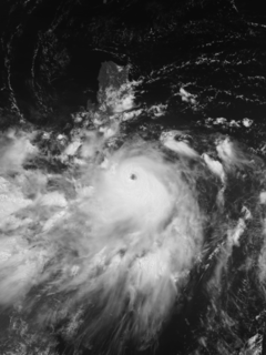
Typhoon Fengshen, known in the Philippines as Typhoon Frank, was the sixth named storm and the fourth typhoon recognised by the Japan Meteorological Agency. The Joint Typhoon Warning Center recognised Fengshen as the seventh tropical depression, the sixth tropical storm, and fifth typhoon of the 2008 Pacific typhoon season.

2009 Pacific typhoon season typhoon season in the Pacific Ocean

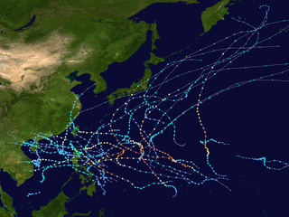
The 2009 Pacific typhoon season was a below average season that spawned only 22 named storms, 13 typhoons, and five super typhoons. It was also recognized as the deadliest season in the Philippines for decades. The first half of the season was very quiet whereas the second half of the season was extremely active. The season's first named storm, Kujira, developed on May 3 while the season's last named storm, Nida, dissipated on December 3.

2014 Pacific typhoon season typhoon season in the Pacific Ocean

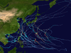
The 2014 Pacific typhoon season was a slightly below average season, featuring 23 tropical storms, 11 typhoons, 8 super typhoons, and 7 Category 5 typhoons. The season's peak months August and September saw minimal activity caused by an unusually strong and a persistent suppressing phase of the Madden–Julian oscillation (MJO). The season ran throughout 2014, though most tropical cyclones typically develop between May and October. The season began with the development of Tropical Storm Lingling on January 18, and ended after Tropical Storm Jangmi which dissipated on January 1 of the next year.

2019 Pacific typhoon season typhoon season in the Pacific Ocean

The 2019 Pacific typhoon season was the costliest Pacific typhoon season on record, just ahead of the previous year. The season was fairly above-average, producing 29 named storms, 17 typhoons, and four super typhoons. It was an event in the annual cycle of tropical cyclone formation, in which tropical cyclones form in the western Pacific Ocean. The season ran throughout 2019, though most tropical cyclones typically develop between May and October. The season's first named storm, Pabuk, reached tropical storm status on January 1, becoming the earliest-forming tropical storm of the western Pacific Ocean on record, breaking the previous record that was held by Typhoon Alice in 1979. The season's first typhoon, Wutip, reached typhoon status on February 20. Wutip further intensified into a super typhoon on February 23, becoming the strongest February typhoon on record, and the strongest tropical cyclone recorded in February in the Northern Hemisphere. The season's last named storm, Phanfone, dissipated on December 29 after it made landfall in the Philippines. The accumulated cyclone energy (ACE) index of this season amounted to 60% above the normal level for Pacific typhoon seasons, at 269, the first such occurrence since the 2016 typhoon season.

Tropical Storm Rumbia (2013)

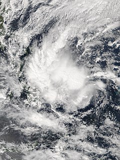
Severe Tropical Storm Rumbia, known in the Philippines as Tropical Storm Gorio, was a tropical cyclone that brought widespread flooding in areas of the Philippines and China late June and early July 2013. The sixth internationally named storm of the season, Rumbia formed from a broad area of low pressure situated in the southern Philippine Sea on June 27. Steadily organizing, the initial tropical depression moved towards the northwest as the result of a nearby subtropical ridge. On June 28, the disturbance strengthened to tropical storm strength, and subsequently made its first landfall on Eastern Samar in the Philippines early the following day. Rumbia spent roughly a day moving across the archipelago before emerging into the South China Sea. Over open waters, Rumbia resumed strengthening, and reached its peak intensity with winds of 95 km/h (50 mph) on July 1, ranking it as a severe tropical storm. The tropical cyclone weakened slightly before moving ashore the Leizhou Peninsula late that day. Due to land interaction, Rumbia quickly weakened into a low pressure area on July 2 and eventually dissipated soon afterwards.

Timeline of the 2014 Pacific typhoon season

This timeline documents all of the events of the 2014 Pacific typhoon season. Most of the tropical cyclones forming between May and November. The scope of this article is limited to the Pacific Ocean, north of the equator between 100°E and the International Date Line. Tropical storms that form in the entire Western Pacific basin are assigned a name by the Japan Meteorological Agency. Tropical depressions that form in this basin are given a number with a "W" suffix by the United States' Joint Typhoon Warning Center. In addition, the Philippine Atmospheric, Geophysical and Astronomical Services Administration (PAGASA) assigns names to tropical cyclones that enter or form in the Philippine area of responsibility. These names, however, are not in common use outside of the Philippines.

Typhoon Hagupit (2014) Pacific typhoon in 2014

Typhoon Hagupit, known in the Philippines as Typhoon Ruby, was the second most intense tropical cyclone in 2014. Hagupit particularly impacted the Philippines in early December while gradually weakening, killing 18 people and causing $114 million in the country. Prior to making landfall, Hagupit was considered the worst threat to the Philippines in 2014, but it was significantly smaller than 2013's Typhoon Haiyan.

Effects of the 2013 Pacific typhoon season in the Philippines

The effects of the 2013 Pacific typhoon season in the Philippines were considered some of the worst in decades. Throughout the year, series of typhoons impacted the country, with the worst damage especially death toll from Typhoon Haiyan during November.

Typhoon Melor Pacific typhoon in 2015

Typhoon Melor, known in the Philippines as Typhoon Nona, was a powerful tropical cyclone that struck the Philippines in December 2015. The twenty-seventh named storm and the eighteenth typhoon of the annual typhoon season, Melor killed 51 people and caused ₱7.04 billion in damage.

Tropical Storm Nida (2016)

Severe Tropical Storm Nida, known in the Philippines as Severe Tropical Storm Carina, was a tropical cyclone that struck Luzon, Philippines and Guangdong, China in late July and early August respectively. The fourth named storm of the annual typhoon season, Nida formed on July 28, 2016 as a tropical depression in the Philippine Sea. Tracking generally north-northwestward, it intensified into a severe tropical storm and skirted northern Luzon before turning to the west-northwest, entering the South China Sea and intensifying further. Nida made landfall over Dapeng Peninsula in Shenzhen late on August 1 and dissipated on August 3.

Typhoon Nock-ten Pacific typhoon in 2016

Typhoon Nock-ten, known in the Philippines as Typhoon Nina, was the strongest Christmas Day tropical cyclone worldwide in terms of 1-minute sustained winds. Forming as a tropical depression southeast of Yap and strengthening into the twenty-sixth tropical storm of the annual typhoon season on December 21, 2016, Nock-ten intensified into the thirteenth typhoon of the season on December 23. Soon afterwards, the system underwent explosive intensification and became a Category 5-equivalent super typhoon early on December 25. Nock-ten weakened shortly afterwards before making eight landfalls over the Philippines. The typhoon weakened rapidly due to the landfalls as it entered the South China Sea on December 26, turned southwest, and ultimately dissipated on December 28 due to the winter monsoon.

Tropical Storm Haikui (2017) 2017 Typhoon

Tropical Storm Haikui, known in the Philippines as Tropical Storm Salome, was a weak tropical cyclone that affected the Philippine archipelagos of Luzon and Visayas. Forming as the twenty-fourth named storm of the 2017 typhoon season, Haikui developed as a tropical depression to the east of Samar on November 9. Traversing some Philippine islands, the system gradually intensified into a named tropical storm by November 10. In that same day, Haikui emerged to the South China Sea.

Tropical Storm Kai-tak 2017 tropical cyclone

Tropical Storm Kai-tak, known in the Philippines as Tropical Storm Urduja, was a late-season tropical cyclone that affected Visayas during December 2017. Forming as the twenty-sixth named storm of the 2017 Pacific typhoon season, Kai-tak formed as a tropical depression near Palau on December 11. Slowly intensifying, the system became a tropical storm on December 14. Due to its slow motion, Kai-tak made landfall in Samar on December 16, and traversed the Philippine islands. Kai-tak later moved in a west-southwestward direction until it dissipated on December 23 near Malaysia.

Tropical Storm Sanba (2018) Pacific typhoon in 2018

Tropical Storm Sanba, known in the Philippines as Tropical Storm Basyang, was a weak tropical cyclone that affected southern Philippines in mid-February 2018. Sanba developed as a tropical depression near Chuuk on February 8. The system generally moved westward. However, it developed slowly due to strong wind shear. The system finally attained tropical storm status on February 11 and passed just south of Yap later that day. Sanba continued to move westward and made landfall over northeastern Mindanao on February 13, very close to where Bolaven made landfall a month ago. After traversing the Philippine islands, Sanba weakened to a tropical depression on February 14 and dissipated two days after in South China Sea.

Typhoon Kammuri (2019) Pacific typhoon in 2019

Typhoon Kammuri, known in the Philippines as Typhoon Tisoy, was a powerful typhoon which impacted the Philippines in early December 2019. The twenty-eighth named storm and sixteenth typhoon of the 2019 Pacific typhoon season, Kammuri developed from a tropical wave situated a couple hundred miles south of the Mariana Islands. From November 25 up until November 27, the system tracked westward at a steady pace and rate of intensification, first making minor impacts in Guam. On November 28, the system intensified into a typhoon as environmental conditions became marginally conducive for significant development. From November 29 up until late December 1, Kammuri was unable to strengthen to previous estimates due to its near stationary movement as a result of weak steering currents, upwelling itself consequently. On December 2, the system tracked westward at a much faster speed of 12 mph (19 km/h) and rapidly intensified over warm Philippine Sea waters, before making landfall in the Bicol Region of the Philippines at peak intensity as a category 4-equivalent typhoon.

References

  1. "Archived copy". Archived from the original on 2019-12-31. Retrieved 2019-12-31.CS1 maint: archived copy as title (link)
  2. "'Ursula' damage hits ₱3 billion" . Retrieved January 6, 2020.
  3. Punongbayan, Michael (December 30, 2019). "'Ursula' death toll climbs to 50". PhilStar.com. Philippine. Retrieved January 2, 2020.
  4. 1 2 3 "Typhoon 201929 (PHANFONE) - Detailed Wind Information". Digital Typhoon. National Institute of Informatics . Retrieved January 6, 2020.
  5. "Tropical Storm Phanfone enters the PAR". Twitter. PAGASA. December 23, 2019. Archived from the original on December 22, 2019.
  6. "Severe Weather Bulletin #1 for Tropical Storm "Ursula" (Phanfone)". Facebook. PAGASA. December 23, 2019. Retrieved January 6, 2020.
  7. "Severe Weather Bulletin #11 for Typhoon "Ursula" (Phanfone)". Facebook. PAGASA. December 24, 2019. Retrieved January 6, 2020.
  8. 1 2 "Severe Weather Bulletin #13 for Typhoon "Ursula" (Phanfone)". Facebook. PAGASA. December 24, 2019. Retrieved January 6, 2020.
  9. "Typhoon 201929 (PHANFONE) - Detailed Track Information". Digital Typhoon. National Institute of Informatics . Retrieved January 6, 2020.
  10. 1 2 "Typhoon Phanfone (Ursula) Raking Through the Central Philippines Over Christmas". December 24, 2019. Archived from the original on December 23, 2019. Retrieved December 24, 2019.
  11. "Severe Weather Bulletin #19 for Typhoon "Ursula" (Phanfone)". Facebook. PAGASA. December 25, 2019. Retrieved January 6, 2020.
  12. "Archived copy". Archived from the original on 2019-12-31. Retrieved 2019-12-31.CS1 maint: archived copy as title (link)
  13. "Archived copy". Archived from the original on 2019-12-26. Retrieved 2019-12-31.CS1 maint: archived copy as title (link)
  14. "Severe Weather Bulletin #30 (Final) for Tropical Storm "Ursula" (Phanfone)". Facebook. PAGASA . Retrieved January 6, 2020.
  15. "20 Dead After Christmas Storm Batters Central Philippines". Time. December 26, 2019. Retrieved December 26, 2019.
  16. "Typhoon Phanfone: At least 16 killed in Philippines on Christmas Day". The Guardian. December 26, 2019. Archived from the original on December 27, 2019. Retrieved December 27, 2019.
  17. 1 2 "Archived copy". Archived from the original on 2019-12-28. Retrieved 2019-12-27.CS1 maint: archived copy as title (link)
  18. "16,000 passengers was stranded on the ports due to Typhoon Ursula (in Filipino)". Patrol.PH. ABS-CBN News. December 24, 2019. Archived from the original on December 28, 2019.
  19. "Typhoon Phanfone: Philippines count cost of deadly storm". BBC News. December 26, 2019. Archived from the original on December 26, 2019. Retrieved December 26, 2019.
  20. "Archived copy". Archived from the original on 2019-12-27. Retrieved 2019-12-27.CS1 maint: archived copy as title (link)
  21. "Typhoon Phanfone: Philippine death toll rises to 28". bbc.com. Archived from the original on 2019-12-27. Retrieved 2019-12-27.
  22. "Archived copy". Archived from the original on 2019-12-28. Retrieved 2019-12-28.CS1 maint: archived copy as title (link)
  23. Punongbayan, Michael (December 30, 2019). "Ursula Death Toll Soars 41". PhilStar.com. Philippine. Retrieved January 2, 2020.
  24. http://bagong.pagasa.dost.gov.ph/learning-tools/philippine-tropical-cyclone-names