Táchira River

Last updated
Táchira River
Rio Tachira, frontera Colombia - Venezuela.JPG
River at the Colombia/Venezuela border
Location
Country Colombia, Venezuela
Physical characteristics
Mouth  
 - location
Pamplonita River

The Táchira River is a river located in Táchira and it divides the border that exists between Venezuela and Colombia in that western state.

Venezuela Republic in northern South America

Venezuela, officially the Bolivarian Republic of Venezuela, is a country on the northern coast of South America, consisting of a continental landmass and a large number of small islands and islets in the Caribbean Sea. The capital and largest urban agglomeration is the city of Caracas. It has a territorial extension of 916,445 km2. The continental territory is bordered on the north by the Caribbean Sea and the Atlantic Ocean, on the west by Colombia, Brazil on the south, Trinidad and Tobago to the north-east and on the east by Guyana. With this last country, the Venezuelan government maintains a claim for Guayana Esequiba over an area of 159,542 km2. For its maritime areas, it exercises sovereignty over 71,295 km2 of territorial waters, 22,224 km2 in its contiguous zone, 471,507 km2 of the Caribbean Sea and the Atlantic Ocean under the concept of exclusive economic zone, and 99,889 km2 of continental shelf. This marine area borders those of 13 states. The country has extremely high biodiversity and is ranked seventh in the world's list of nations with the most number of species. There are habitats ranging from the Andes Mountains in the west to the Amazon basin rain-forest in the south via extensive llanos plains, the Caribbean coast and the Orinoco River Delta in the east.

Colombia Country in South America

Colombia, officially the Republic of Colombia, is a sovereign state largely situated in the northwest of South America, with territories in Central America. Colombia shares a border to the northwest with Panama, to the east with Venezuela and Brazil and to the south with Ecuador and Peru. It shares its maritime limits with Costa Rica, Nicaragua, Honduras, Jamaica, Haiti, and the Dominican Republic. Colombia is a unitary, constitutional republic comprising thirty-two departments, with the capital in Bogota.

The Simón Bolívar International Bridge across the Táchira River connects the city of San Antonio del Tachira in Venezuela with the small town of La Parada in Colombia. [1] The first major city in Colombia after the border is Cúcuta. [2]

Simón Bolívar International Bridge A bridge connecting Colombia and Venezuela

The Simón Bolívar International Bridge is a 300m long bridge across the Táchira River on the Venezuelan/Colombian border, connecting the city of San Antonio del Tachira in Venezuela with the small town of La Parada in Colombia. The first major city in Colombia after the border is Cúcuta.

Cúcuta Municipality of Colombia in Norte de Santander

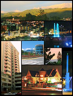
Cúcuta, officially San José de Cúcuta, is a Colombian city, capital of Norte de Santander department. It is located in the northeast of the country, in the eastern branch of the Colombian Andes, on the border with Venezuela. Cúcuta has a population of approximately 750,000 people according to the 2005-2020 census, making it the 6th largest city in the country. Due to its proximity with Venezuela, Cúcuta is an important commercial center. Hosting many billion dollar companies. The international border in Cúcuta is said to be the most dynamic of South America. The city has a length of 12 kilometres from north to south and 11 kilometres from east to west. It is divided into 10 communes and it is the political, economic, administrative, industrial, cultural and tourism hub of the Norte de Santander department.

Related Research Articles

Apure State of Venezuela

Apure State is one of the 23 states (estados) into which Venezuela is divided. Its territory formed part of the provinces of Mérida, Maracaibo, and Barinas, in accordance with successive territorial ordinations pronounced by the colonial authorities. In 1824 the Department of Apure was created, under jurisdiction of Barinas, which laid the foundations for the current entity. In 1856 it separated from Barinas and for the first time Apure appeared as an independent province, which in 1864 acquired the status of state. In 1881, however, a new territorial division combined Apure and Guayana to form a single state named Bolívar. In 1899 it reestablished its autonomy and finally, by means of the Constitution of 1909, gained its current borders.

Táchira State of Venezuela

Táchira State is one of the 23 states of Venezuela. The state capital is San Cristóbal.

San Cristóbal, Táchira Place in Táchira, Venezuela

San Cristóbal is the capital city of the Venezuelan state of Táchira. It is located in a mountainous region of Western Venezuela. The city is situated 818 metres (2,684 ft) above sea level in the northern Andes overlooking the Torbes River, 56 kilometres (35 mi) from the Colombian border. San Cristóbal was founded on March 31, 1561 by Juan de Maldonado. From its inception, the city evolved rapidly as one of the most progressive and important centers of commerce in the country, due primarily to its rich soil and its proximity to the border with Colombia.

Cordillera de Mérida mountain range

The Cordillera de Mérida is a series of mountain ranges, or massif, in northwestern Venezuela. The Cordillera de Mérida is a northeastern extension of the Andes Mountains and the most important branch of Venezuelan Andes. The ranges run southwest-northeast between the Venezuelan-Colombian border and the Venezuelan Coastal Ranges. The Táchira depression separates the Cordillera de Mérida from the Cordillera Oriental, which forms the Colombia-Venezuela border.

Táchira may refer to:

San Antonio del Táchira Place in Táchira, Venezuela

San Antonio del Táchira is a city in the Venezuelan Andean state of Táchira. The busy highway across the Simón Bolívar International Bridge linking the cities of Cúcuta, Colombia, and San Cristóbal, Venezuela, passes through San Antonio del Táchira, making it an important gateway between the two nations. This city is the shire town of the Municipio Bolívar de Táchira and, according to the 2001 Venezuelan census, the municipality has a population of 48,171.

Hydrography of Norte de Santander

The department of Norte de Santander in northwestern Colombia, and its capital, Cúcuta, contains several rivers. The rivers are mostly part of the Maracaibo Lake basin, with the southeastern section located in the Magdalena River basin. Important fluvial elements are the Zulia, Catatumbo and Pamplonita Rivers. The entity in charge of taking care of these hydrology of Norte de Santander is Corponor.

Rubio, Venezuela Place in Táchira, Venezuela

Rubio is a town in the Venezuelan Andean state of Táchira. Founded in 1794 by Gervasio Rubio, this town is the shire town of the Junín Municipality and, according to the 2001 Venezuelan census, the municipality has a population of 68,869.

Sierra Nevada de Mérida glacier

The Sierra Nevada de Mérida is the highest mountain range in the largest massif in Venezuela, the Cordillera de Mérida, which in turn is part of the northern extent of the Cordillera de los Andes. The Sierra Nevada de Mérida includes the highest peaks in Venezuela, Pico Bolívar, which has an elevation of 4,981 metres (16,342 ft), Pico Humboldt, Pico Bonpland and others.

César Eduardo González Venezuelan footballer

César Eduardo González Amais is a Venezuelan football midfielder. He currently plays for Deportivo La Guaira.

Juan Vicente Gómez International Airport airport

Juan Vicente Gómez International Airport, is an airport serving San Antonio del Táchira, in the Táchira state of Venezuela. In June 1993, it was renamed in honor of the early Venezuelan President Juan Vicente Gómez, who was from Táchira, in a ceremony presided over by interim President Ramón José Velásquez.

Táchira helicopter crash

The Táchira helicopter crash was the loss of a Venezuela Army helicopter and its 18 occupants on 3 May 2009. The helicopter crashed at around midday local time near El Alto de Rubio in the north-western state of Táchira in Venezuela. All eighteen people aboard the aircraft were killed. The dead included Brigadier-General Domingo Faneite, two army pilots, fourteen other army personnel and one civilian, named as Cristian Velazquez. Venezuelan President Hugo Chávez, who was a retired army Lieutenant-Colonel, announced the incident in his weekly television broadcast and said "I pay tribute to these soldiers of the homeland, especially Gen Faneite, who was my cadet".

Tamá National Natural Park protected area

The Tamá National Natural Park is a national park located in the Tamá Massif of the Andean Region of Colombia, between the municipalities Toledo and Herrán, in the department of Norte de Santander, in the northeastern part of the Eastern Ranges of the Colombian Andes. One of the main attractions of the park is a 820-metre-high (2,690 ft) waterfall, one of the world's highest.

Colombia–Venezuela border international border

The Colombia–Venezuela border is an ongoing international border of 2,219 kilometers that separates the territories of Colombia and Venezuela, with a total of 603 milestones that demarcate the line. It is the longest border of both Colombia and Venezuela.

The 2016 Pan American Road Cycling Championships took place at San Cristóbal, Táchira, Venezuela, May 19–22, 2016.

El Tamá National Park

The El Tamá National Park It is a protected area with the status of a national park that is located between the Andes and plains of Venezuela. It protects part of the Tamá Massif. It has an area of 139,000 hectares and is located in the states of Táchira and Apure, near the border with Colombia. Created as a National Park on December 12, 1978, by the then President Carlos Andrés Pérez.

Las Tienditas Bridge A bridge connecting Colombia and Venezuela

Las Tienditas International Bridge is a vehicular and pedestrian bridge connecting Tachira, Venezuela with Norte de Santander, Colombia.

Ureña, Táchira Place in Táchira, Venezuela

Ureña is a city and the shire town of Pedro María Ureña Municipality, Táchira in Venezuela. It is located on the border with Colombia. The city was founded by Pedro María Ureña, having been elevated to the category of parish by means of the provincial law of December 4, 1851.

References

  1. "The bridge of desperation". BBC News.
  2. Andrew Rosati (12 October 2017). "Thousands Are Fleeing Venezuela by Two-Lane Border Bridge". www.bloomberg.com. Retrieved 4 September 2018.