
Bình Thuận is a province of Vietnam. It is located on the country's South Central Coast. It is sometimes seen as part of the Southeast region. The province is known for its scenery and beaches. There are also a number of sites of archaeological significance.
Hoàng Tụy is a prominent Vietnamese applied mathematician. He is considered one of two founders of the mathematical institutions of Vietnam; the other is Lê Văn Thiêm.
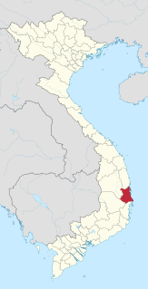
Phú Yên is a coastal province in the South Central Coast of Vietnam. It is the easternmost province of Vietnam's mainland.

Dong Tac Airport is located just south of Tuy Hòa within the Phú Yên Province, along the central coast of southern Vietnam.
Tuy Hòa is the capital city of Phú Yên Province in south-central Vietnam. The city has a total area of 107 km2 and a population of 202,030. The city is located approximately midway between Nha Trang and Qui Nhơn.

National Route 1A is the trans-Vietnam highway. The route begins at km 0 at Huu Nghi Quan Border Gate near the China-Vietnam border. The route ends at at Năm Căn township in Cà Mau Province.

Long Biên Bridge is a historic cantilever bridge across the Red River that connects two districts, Hoan Kiem and Long Bien of the city of Hanoi, Vietnam. It was originally called Paul Doumer Bridge.
Tuy Phước is a rural district (huyện) of Bình Định Province in the South Central Coast region of Vietnam. The district capital lies at Tuy Phước. The district has 13 administrative units including the towns Diêu Trì, Tuy Phước and the communes Phước Thắng, Phước Hưng, Phước Hoà, Phước Quang, Phước Sơn, Phước Hiệp, Phước Lộc, Phước Thuận, Phước Nghĩa, Phước An and Phước Thành.
Bắc Quang is a rural district of Ha Giang province in the northeastern region of Vietnam. As of 2003, the district had a population of 103,064. The district covers an area of 1,084 km². The district capital lies at Vĩnh Tuy.
Gò Quao is a rural district (huyện) of Kien Giang province in the Mekong River Delta region of Vietnam.
Tuy An is a district (huyện) of Phú Yên Province in the South Central Coast region of Vietnam.

Tuy Hòa railway station is one of the main railway stations on the North–South Railway in Vietnam. It serves the city of Tuy Hòa, the capital city of Phú Yên Province in south-central Vietnam.

Côn River is a river of Vietnam. With a length of 171 km, it is the longest river in Bình Định Province. Much of it can be used as an inland waterway for transportation.
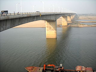
The Vĩnh Tuy Bridge is a bridge over the Red River in Hanoi which was completed 2008. It was one of the Millennial Anniversary of Hanoi commemorative projects along with the Thanh Trì Bridge.
Operation Van Buren was a harvest security operation conducted by the 1st Brigade, 101st Airborne Division in the Tuy Hòa Valley, Phú Yên Province, lasting from 15 January to 25 February 1966. During Operation Van Buren, many civilians were alleged to have been killed in and around the Tuy Hoa Valley by South Korean troops. These were reported as "enemy KIA", as distinctions were not made concerning body counts. Following these operations, the area became a hotbed of resistance and Viet Cong activity.
Operation Geronimo was a joint operation conducted by U.S., South Korean and South Vietnamese forces in Phú Yên Province, lasting from 31 October to 4 December 1966.
Operation Hardihood was a security operation conducted from 16 May to 8 June 1966 during the Vietnam War by the U.S. 503rd Infantry Regiment, the 1st Battalion, Royal Australian Regiment (1RAR) and the 5th Battalion, Royal Australian Regiment in Phước Tuy Province, South Vietnam to secure the area around Nui Dat for the establishment of a base area for the 1st Australian Task Force.

Tuy Hoa Air Base is a former air force base in Vietnam, being closed in 1970. It was built by the United States in 1966 and was used by the United States Air Force (USAF) during the Vietnam War in the II Corps Tactical Zone of South Vietnam. It was captured by the People's Army of Vietnam in April 1975 and was abandoned for several decades. Today, the site has been redeveloped as Dong Tac Airport.

