
Atka Island is the largest island in the Andreanof Islands of the Aleutian Islands of Alaska. The island is 50 miles (80 km) east of Adak Island. It is 65 miles (105 km) long and 2–20 miles (3–30 km) wide with a land area of 404.6 square miles (1,048 km2), making it the 22nd largest island in the United States. The northeast of Atka Island contains the Korovin volcano which reaches a peak of 5,030 feet (1,533 m). Oglodak Island is located 3.4 miles off Cape Kigun, Atka's westernmost point.

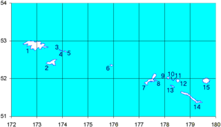
The Andreanof Islands are a group of islands in the Aleutian Islands, in southwestern Alaska. They are located at about 52° North and 172°57' to 179°09' West.
The Rat Islands are a volcanic group of islands in the Aleutian Islands in southwest Alaska, between Buldir Island and the Near Islands group to its west, and Amchitka Pass and the Andreanof Islands group to its east, at about 51°47′17″N178°18′10″E.
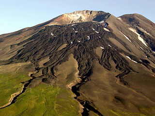
Kanaga Island is a part of the Andreanof Islands group of the Aleutian Islands in Alaska. The island measures 30 miles (48 km) long and between 4–8 miles (6.4–12.9 km) wide with an area of 142 sq mi (368 km2), making it the 42nd largest island in the United States. The island's most notable feature is Mount Kanaga, a 4,288-foot-high (1,307 m) volcano which last erupted in 1995.
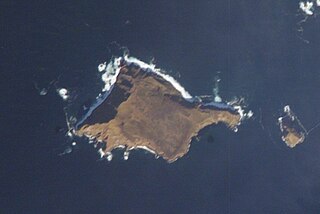
Khvostof Island or Atanak is an island in the Rat Islands archipelago of the Western Aleutian Islands, Alaska. The island is 2 kilometres (1.2 mi) long and 2.74 kilometres (1.70 mi) wide.
and Khvostof.jpg|thumb|300px|right|NASA-Picture of Davidof, on left side Khvostof Island.]]
Ugamak Island is one of the Krenitzin Islands, a subgroup of the Fox Islands group of the eastern Aleutian Islands, Alaska. Ugamak is an Aleut word transcribed by Father Veniaminov (1840) which, according to R. H. Geoghegan, may mean "ceremony island". It is 5.9 miles (9.5 km) long and is located 32 miles (51 km) east of Akutan Island. Ugamak Bay is situated on the southeast coast of Ugamak, and Ugamak Strait is a three-mile-wide channel that separates Ugamak from Kaligagan Island to the west.
Gareloi or Anangusook is a volcanic island in the Delarof Islands of the Aleutian Islands of Alaska. It is located between the Tanaga Pass and the Amchitka Pass.
Igitkin Island is a small island located in an area between Adak Island and Atka Island among other small islands. The island belongs to the Andreanof Islands of the Aleutian Islands of Alaska.
Ilak Island is a small island in the eastern Delarof Islands, Aleutian Islands of Alaska.
Kagalaska Island is an island in the Andreanof Islands of the Aleutian Islands of Alaska.
Little Tanaga Island is an island located in the Andreanof Islands of the Aleutian Islands of Alaska. It lies between Kagalaska Island and Umak Island. The island is 12.5 kilometres (7.8 mi) long and 16.3 kilometres (10.1 mi) wide.
Tagalak Island is an island located in the central area of the Andreanof Islands of the Aleutian Islands of Alaska. West of the island lies Chugul. The island is 6.3 kilometres (3.9 mi) long and 7 kilometres (4.3 mi) wide.
Umak Island is an island lying in a group of small islands situated between Adak Island and Atka Island in the Andreanof Islands group of the Aleutian Islands of Alaska. It is 11.7 kilometres long and 7.8 kilometres wide.
Unalga Island is one of the Fox Islands subgroup of the Aleutian Islands of southwestern Alaska, United States. It lies just northeast of Unalaska Island and across Akutan Pass from Akutan Island to its northeast. It is the westernmost island in the Aleutians East Borough. Unalga Island has a land area of 11.004 square miles and is unpopulated. The island is 6.7 kilometres (4.2 mi) long and 8.2 kilometres (5.1 mi) wide.
Egg Island is a small island in the Fox Islands subgroup of the Aleutian Islands in the U.S. state of Alaska. It lies off the eastern end of Unalaska Island and just off the northeastern tip of Sedanka Island. It is the easternmost island in the Aleutians West Census Area of Alaska. The island has a land area of 311.12 acres (1.259 km²) and is uninhabited. It is 19.3 kilometres (12.0 mi) long and 12 kilometres (7.5 mi) wide.
Akutan Island is an island in the Fox Islands group of the eastern Aleutian Islands in the Aleutians East Borough of Alaska.
The Aleutian Islands, also called the Aleut Islands or Aleutic Islands and known before 1867 as the Catherine Archipelago, are a chain of 14 large volcanic islands and 55 smaller ones belonging to both the U.S. state of Alaska and the Russian federal subject of Kamchatka Krai. They form part of the Aleutian Arc in the Northern Pacific Ocean, occupying an area of 6,821 sq mi (17,666 km2) and extending about 1,200 mi (1,900 km) westward from the Alaska Peninsula toward the Kamchatka Peninsula in Russia, and mark a dividing line between the Bering Sea to the north and the Pacific Ocean to the south. Crossing longitude 180°, at which point east and west longitude end, the archipelago contains both the westernmost part of the United States by longitude and the easternmost by longitude. The westernmost U.S. island in real terms, however, is Attu Island, west of which runs the International Date Line. While nearly all the archipelago is part of Alaska and is usually considered as being in the "Alaskan Bush", at the extreme western end, the small, geologically related Commander Islands belong to Russia.


