
Fútbol Club Atlas is a Mexican football club. Atlas plays in Guadalajara, Mexico, in the Liga MX. The club's home stadium is Estadio Jalisco in Guadalajara.
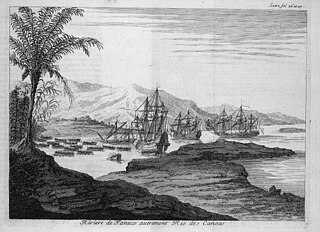
The Pánuco River, also known as the Río de Canoas, is a river in Mexico fed by several tributaries including the Moctezuma River and emptying into the Gulf of Mexico. The river is approximately 510 kilometres (320 mi) long and passes through or borders the states of Mexico, Hidalgo, Querétaro, San Luis Potosí, Tamaulipas, and Veracruz. Since one of the headwaters of the Moctezuma River is the Tula River, the Pánuco ultimately drains the Valley of Mexico containing Mexico City.

The Myakka River is a river in southwestern Florida. It arises near the Hardee-Manatee county line and flows southwest and then southeast through Manatee, Sarasota and Charlotte counties to Charlotte Harbor, an arm of the Gulf of Mexico. The river is 72 miles (116 km) long and has a drainage basin of 314.7 square miles (815 km2). The last 20 miles (32 km) of the river is tidal and brackish.

The Lower Colorado River Valley ("LCRV") is the river region of the lower Colorado River of the southwestern United States in North America that rises in the Rocky Mountains and has its outlet at the Colorado River Delta in the northern Gulf of California in northwestern Mexico, between the states of Baja California and Sonora. This north–south stretch of the Colorado River forms the border between the U.S. states of California/Arizona and Nevada/Arizona, and between the Mexican states of Baja California/Sonora.
The Armería River is a river of Mexico.
The Atoyac River is a river in Oaxaca, Mexico. The Atoyac flows into the Rio Verde which empties into the Pacific near Laguna Chacahua, in Lagunas de Chacahua National Park, 90 km west of Puerto Escondido. The mountainous terrain of the region it occupies allows for no navigable rivers; instead, there are a large number of smaller ones, which often change name from area to area. The continental divide passes through the state, meaning that there is drainage towards both the Gulf of Mexico and the Pacific Ocean. Most of the drainage towards the Gulf is represented by the Papaloapan and Coatzacoalcos Rivers and their tributaries such as the Grande and Salado Rivers. Three rivers account for most of the water headed for the Pacific: the Mixteco River, Tehuantepec River, and the Atoyac, with their tributaries.
Blue Creek is a river that runs along the Belize–Mexico border. It is a tributary of the Hondo River. It is known as the Río Azul in Mexico.

The Cazones River is a river of Mexico.

The Tuxpan River in Mexico flows into the Gulf of Mexico near the city and port of Tuxpan in the state of Veracruz. Its principal sources are the Vinazco River, which rises in Hidalgo, and the Pantepec River, which rises in Puebla, both of which enter the territory of Veracruz before the city of Álamo, in Temapache Municipality, uniting to form the Tuxpan, which has become an important passage for harbor access, strengthening the region's economy. Passing the city of Tuxpan it forms the lagoon of Tampamachoco close to its mouth.
The Tuxpan (Coahuayana) River is a river of Mexico.

The Tamesí River is a river in northeast Mexico. It is a part of the Pánuco River basin.
The Sacramento River is a river in the state of Chihuahua, Mexico.

The SabinasRiver is a river of Mexico. It is a tributary of the Rio Salado, which in turn flows into the Rio Grande.
Río Verde,, is a river of San Luis Potosí state in eastern Mexico.
The Moctezuma River is a river in Mexico that drains the eastern side of the Trans-Mexican Volcanic Belt. It is a tributary of the Pánuco River and flows through the Mexican states of Mexico, Hidalgo, Querétaro, San Luis Potosí, and Veracruz.
The Lacantún River is a river of Mexico.
The Cutzamala River is a river of Mexico.
Black Creek of Arizona is a 55-mi (89 km) long north tributary of the Puerco River, in northeast Arizona and northwest New Mexico.

