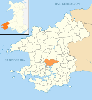
Pembrokeshire is a county in the south-west of Wales. It is bordered by Carmarthenshire to the east, Ceredigion to the northeast, and is otherwise surrounded by the sea. Haverfordwest is the largest town and administrative headquarters of Pembrokeshire County Council.

Haverfordwest is the county town of Pembrokeshire, Wales, and the most populous urban area in Pembrokeshire with a population of 14,596 in 2011. It is also a community, being the second most populous community in the county, with 12,042 people, after Milford Haven. The suburbs include the former parish of Prendergast, Albert Town and the residential and industrial areas of Withybush.

Neyland is a town and community in Pembrokeshire, Wales, lying on the River Cleddau and the upstream end of the Milford Haven estuary. The Cleddau Bridge carrying the A477 links Pembroke Dock with Neyland.
Llawhaden is a village, parish and community in the Hundred of Dungleddy, Pembrokeshire, West Wales. The community of Llawhaden includes the parish of Robeston Wathen, part of Narberth and the hamlet of Gelli, and had a population of 634 in 2001, increasing to 688 at the 2011 Census.
Llangolman is a village and parish in the southeastern Preseli Hills in Pembrokeshire, Wales. It is part of the community of Mynachlog-ddu. There are prehistoric remains nearby and the parish has a history of slate and clay quarrying.

Llangwm is a small village, parish and community of around 450 properties situated on the Llangwm Pill off the River Cleddau estuary near Haverfordwest, Pembrokeshire, Wales. It has a history of mining and fishing and is in the largely English-speaking south of the county.

The Hundred of Roose was a hundred in Pembrokeshire, Wales. It has its origins in the pre-Norman cantref of Rhos and was formalised as a hundred by the Laws in Wales Acts 1535–1542. Its area was about 102 square miles (260 km2). The area became an English "plantation" in the 12th century, part of the English-speaking Little England beyond Wales.
Boulston is a small settlement and former parish on the left bank of the Western Cleddau river in Pembrokeshire, Wales, in the community of Uzmaston, Boulston and Slebech.

Castlemorris is a small village in the parish and community of Mathry, Pembrokeshire, Wales, south of the Western Cleddau river, on the B4331 road between Mathry and Letterston. It has a population of roughly 150 people.

Martletwy is a village, parish and community in the county of Pembrokeshire, Wales.

Treffgarne is a small village and parish in Pembrokeshire, south-west Wales. It lies to the south of the Preseli Hills close to the Western Cleddau river, and close to the main A40 road from Fishguard to Haverfordwest. The area has an interesting local geology and evidence of mineral extraction at least as far back as Roman times. The present village is medieval in origin.
Slebech was a community in Pembrokeshire, Wales, which is now part of the combined community of Uzmaston and Boulston and Slebech, a sparsely populated community on the northern shore of the Eastern River Cleddau. The community shares boundaries with the communities of Wiston and Llawhaden and mainly consists of farmland and woodland. Much of the community is within the Pembrokeshire Coast National Park and Picton Castle's stable block loft is an important breeding roost for the rare Greater Horseshoe Bat.

Hayscastle or Hays-Castle is a village, parish and community of Pembrokeshire in West Wales, 7½ miles from Haverfordwest on the B4330 road.
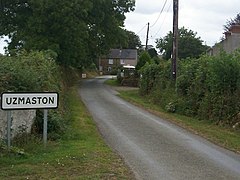
Uzmaston, Boulston and Slebech is a community in Pembrokeshire, Wales, which includes the villages of Uzmaston, Boulston and Slebech, and the Haverfordwest suburb of Cartlett.

Rudbaxton is a village, parish and a local government community in the county of Pembrokeshire, Wales. It is 81 miles (130 km) from Cardiff and 208 miles (335 km) from London.

Prendergast is a former village and parish in Pembrokeshire, Wales, now a suburb of Haverfordwest, Pembrokeshire's county town. The name survives as an electoral ward of Haverfordwest. The Western Cleddau forms the parish's western boundary, and the Hiog, a tributary of the Cleddau, the eastern boundary.

Robeston Wathen is a rural village and parish in Pembrokeshire, Wales, 2 miles (3.2 km) west of Narberth, on the former Narberth to Haverfordwest turnpike subsequently designated the A40 which bypassed the village in 2011. Robeston Wathen is in the community of Llawhaden.

Llanstinan is a rural parish in the community of Scleddau, north Pembrokeshire, Wales, 3 miles (4.8 km) south of Fishguard.
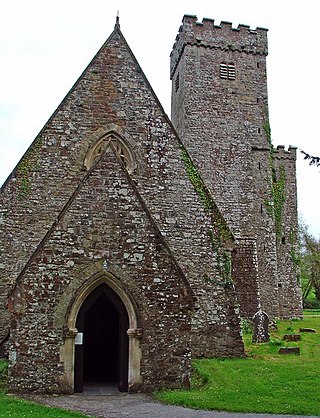
St Michael's Church is a Grade I listed building and parish church in the community and parish of Rudbaxton in Pembrokeshire, Wales. The building dates from the 15th century, and has a 12th-century font. It was listed on 1 March 1963 as a fine example of a substantial mediaeval double-nave church with important memorials.