
Ørskog is a municipality in Møre og Romsdal county, Norway. It is part of the Sunnmøre region. The administrative centre is the village of Sjøholt. The other main village is Vaksvika, about 7.5 kilometres (4.7 mi) south of Sjøholt. The European Route E39/E136 highway runs through the municipality, connecting the towns of Ålesund and Molde. Rauma Group is the largest company in Ørskog in terms of turnover.

Bjerka is a village in the municipality of Hemnes in Nordland county, Norway. It is located along the European route E06 highway and the Nordland Line, about 20 kilometres (12 mi) southeast of Hemnesberget and about 7 kilometres (4.3 mi) north of the municipal center of Korgen.

Rafsbotn (Norwegian) or Rässivuono (Kven) is a village in Alta Municipality in Finnmark county, Norway. The village sits at the southeast end of the Altafjorden, along the European route E06 highway, about 12 kilometres (7.5 mi) northeast of the town of Alta. The name comes from the Sami place name Ráššvuotna which means a clay seabed. The 0.34-square-kilometre (84-acre) village has a population (2017) of 408 which gives the village a population density of 1,200 inhabitants per square kilometre (3,100/sq mi). Rafsbotn has a ski slope and Rafsbotn Chapel.

Sandane is the administrative centre of the municipality of Gloppen in Sogn og Fjordane county, Norway. It is located at the end of the Gloppefjorden, along the European route E39 highway. Sandane is 20 kilometres (12 mi) south of the village of Nordfjordeid and about 16 kilometres (9.9 mi) west of the village of Byrkjelo. Sandane Airport, Anda is located 10 kilometres (6.2 mi) northwest of Sandane along highway E39. Sandane has several suburban areas that surround the nearby fjord such as Sørstranda to the west and Vereide to the northwest.
Batnfjordsøra is the administrative centre of Gjemnes Municipality in Møre og Romsdal county, Norway. The village is located at the end of the Batnfjorden at the mouth of the river Batnfjordelva. European Route E39 passes through the village on its way from Molde to Trondheim. The 0.32-square-kilometre (79-acre) village has a population (2013) of 319, which gives the village a population density of 997 inhabitants per square kilometre (2,580/sq mi).

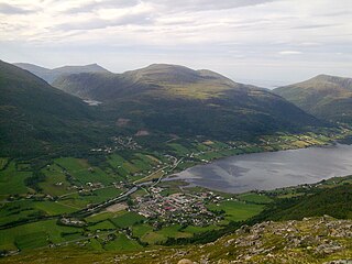
Sjøholt is the administrative centre of Ørskog Municipality in Møre og Romsdal county, Norway. The village is located along the northern shore of the Storfjorden, about 10 kilometres (6.2 mi) east of the village of Skodje. The village of Stordal is located about 18 kilometres (11 mi) to the south, through several tunnels. Sjøholt is located roughly halfway between the towns of Ålesund and Molde, along European route E39 and European route E136.

Andselv is a village in Målselv Municipality in Troms county, Norway. The village lies along the Andselva river in the urban area called Bardufoss. Andselv is located just north of Bardufoss Airport along the European route E6 highway about 2 km (1.2 mi) north of the village of Heggelia and 3.5 km (2.2 mi) south of the village of Andslimoen.
Hesseng is a village in Sør-Varanger Municipality in Finnmark county, Norway. The village lies about 5 kilometres (3.1 mi) south of the town of Kirkenes. The village of Hesseng lies at the intersection of the European route E105 and European route E06 highways. The other suburbs of Sandnes and Bjørnevatn lie just to the south of Hesseng. The 1.18-square-kilometre (290-acre) village has a population (2013) of 1,761; which gives the village a population density of 1,492 inhabitants per square kilometre (3,860/sq mi).

Sande is the administrative centre of the municipality of Gaular in Sogn og Fjordane county, Norway. The village is located along the Gaula River, about 10 kilometres (6.2 mi) from where the river meets the Dalsfjorden. The 0.59-square-kilometre (150-acre) village has a population (2013) of 745, giving the village a population density of 1,263 inhabitants per square kilometre (3,270/sq mi). Sande Church is located in this village, serving the people of the central part of the municipality.

Vassenden is a village in the municipality of Jølster in Sogn og Fjordane county, Norway. It is located along the river Jølstra on the western shore of the lake Jølstravatnet, and about 10 kilometres (6.2 mi) north of the lake Holsavatnet. The 0.37-square-kilometre (91-acre) village has a population (2013) of 374, giving the village a population density of 1,011 per square kilometre (2,620/sq mi).

Vigeland is the administrative center of Lindesnes municipality in Vest-Agder county, Norway. The village is located along the river Audna, about 5 kilometres (3.1 mi) north of the river's mouth at the Snigsfjorden. The European route E39 highway runs east-west through Vigeland, connecting it to the town of Mandal, about 12 kilometres (7.5 mi) to the southeast. The 1.19-square-kilometre (290-acre) village has a population (2015) of 1,471 which gives the village a population density of 1,236 inhabitants per square kilometre (3,200/sq mi).

Etnesjøen or Etne is the administrative centre of Etne municipality in Hordaland county, Norway. The village is located at the inner end of the Etnefjorden, along the European route E134 highway, about 8 kilometres (5.0 mi) south of the village of Skånevik and about 10 kilometres (6.2 mi) northeast of the village of Ølensjøen.

Skare or Skarde is a village in Odda municipality in Hordaland county, Norway. The village is located about 15 kilometres (9.3 mi) straight south of the town of Odda and about 5 kilometres (3.1 mi) northwest of the village of Seljestad. The village sits at the junction of Norwegian National Road 13 and European route E134. Skare Church is located in the village. The 0.29-square-kilometre (72-acre) village has a population (2013) of 320, giving the village a population density of 1,103 inhabitants per square kilometre (2,860/sq mi). The Espelandsfossen waterfall lies about 1.5 kilometres (0.93 mi) north of the village, just off the side of the National Road 13.
Søfteland or Syfteland is a village in Os municipality in Hordaland county, Norway. It lies on the Bergen Peninsula, along the European route E39 highway, about 6 kilometres (3.7 mi) north of the municipal centre of Osøyro and about 20 kilometres (12 mi) south of the city of Bergen. The mountain Møsnuken lies about 3.5 kilometres (2.2 mi) east of the village and the mountain Lyshornet lies about 2.3 kilometres (1.4 mi) west of the village. The 0.94-square-kilometre (230-acre) village has a population (2013) of 1425, giving the village a population density of 1,516 inhabitants per square kilometre (3,930/sq mi).
Brusdalsvatnet is a large lake on the island of Oksenøya in Møre og Romsdal county, Norway. The lake sits on the border between Ålesund Municipality and Skodje Municipality. The lake is a reservoir that is the water supply for the nearby city of Ålesund. The 7.3-square-kilometre (2.8 sq mi) lake is about 9.5 by 1.3 kilometres.

Skodje is the administrative centre of Skodje Municipality in Møre og Romsdal county, Norway. The village is located along the shore of the Skodjevika, an inlet off the main Ellingsøyfjorden. The village of Valle is located along European route E39/European route E136 highway, just a few kilometers south of the village. The 1.66-square-kilometre (410-acre) village of Skodje has a population (2013) of 2,265; giving the village a population density of 1,364 inhabitants per square kilometre (3,530/sq mi). This makes it the largest urban area in the municipality. Skodje Church is located in the village and the historic Skodje Bridge lies just west of the village.

Vestnes is the administrative centre of Vestnes Municipality in Møre og Romsdal county, Norway. The village is located on the western shore of the Tresfjorden, near where the fjord empties into the main Romsdal Fjord. The village lies along the European route E39 highway. The 1.87-square-kilometre (460-acre) village has a population (2013) of 2,241 which gives the village a population density of 1,198 inhabitants per square kilometre (3,100/sq mi), and making it the largest settlement in the whole municipality.

Re or Reed is a village in Gloppen Municipality in Sogn og Fjordane county, Norway. The village is located on the eastern shore of the lake Breimsvatnet, along the European route E39 highway, about 5 kilometres (3.1 mi) west of the village of Byrkjelo and about 12 kilometres (7.5 mi) southeast of the municipal centre of Sandane. The 0.49-square-kilometre (120-acre) village has a population (2013) of 365, giving the village a population density of 745 inhabitants per square kilometre (1,930/sq mi).


