Micronesia is a subregion of Oceania, composed of thousands of small islands in the western Pacific Ocean. It has a shared cultural history with two other island regions: Polynesia to the east and Melanesia to the south.

The Northern Mariana Islands, officially the Commonwealth of the Northern Mariana Islands, is an insular area and commonwealth of the United States consisting of 14 islands in the northwestern Pacific Ocean. The CNMI includes the 14 northernmost islands in the Mariana Archipelago except the southernmost island of the chain, Guam, which is a separate U.S. territory. The CNMI and Guam are the westernmost point and territory of the United States.

The Northern Territory is an Australian territory in the central and central northern regions of Australia. It shares borders with Western Australia to the west, South Australia to the south, and Queensland to the east. To the north, the territory looks out to the Timor Sea, the Arafura Sea and the Gulf of Carpentaria, including Western New Guinea and other Indonesian islands. The NT covers 1,349,129 square kilometres (520,902 sq mi), making it the third-largest Australian federal division, and the 11th-largest country subdivision in the world. It is sparsely populated, with a population of only 246,700, making it the least-populous of Australia's eight states and major territories, with fewer than half as many people as Tasmania.

The Virgin Islands are geologically and biogeographically the easternmost part of the Greater Antilles, the northern islands belonging to the Puerto Rican Bank and St. Croix being a displaced part of the same geologic structure. Politically, the British Virgin Islands have been governed as the western island group of the Leeward Islands, which are the northern part of the Lesser Antilles, and form the border between the Caribbean Sea and the Atlantic Ocean. The archipelago is separated from the true Lesser Antilles by the Anegada Passage and from the main island of Puerto Rico by the Virgin Passage.
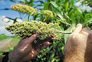
Sorghum is a genus of flowering plants in the grass family Poaceae. Seventeen of the 25 species are native to Australia, with the range of some extending to Africa, Asia, Mesoamerica, and certain islands in the Indian and Pacific Oceans. One species is grown for grain, while many others are used as fodder plants, either cultivated in warm climates worldwide or naturalized, in pasture lands. Sorghum is in the subfamily Panicoideae and the tribe Andropogoneae.
The protected areas of the Northern Territory consists of protected areas managed by the governments of the Northern Territory and Australia and private organisations with a reported total area of 335,527 square kilometres (129,548 sq mi) being 24.8% of the total area of the Northern Territory of Australia.

Territories of the United States are sub-national administrative divisions overseen by the federal government. They differ from U.S. states and Native American tribes, which have limited sovereignty. The territories are classified by incorporation and whether they have an "organized" government through an organic act passed by Congress.

In Australia, electoral districts for the Australian House of Representatives are called divisions or more commonly referred to as electorates or seats. There are currently 151 single-member electorates for the Australian House of Representatives.
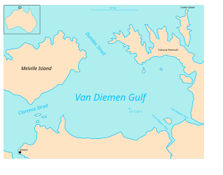
Clarence Strait in northern Australia separates Melville Island from the mainland of Australia. It also connects the Beagle Gulf in the west to the Van Diemen Gulf in the east. It is approximately 50 km (31 mi) north of the city of Darwin.
This overview contains the flags of dependent territories and other areas of special sovereignty.

British Arctic territories were territories claimed by the United Kingdom in North America, consisting of the islands of what is now known as the Canadian Arctic Archipelago. The region was part of British North America.

The states and territories are the first-level administrative divisions of the Commonwealth of Australia. They are the second level of government in Australia, located between the federal and local government tiers.

Nunavut is the newest, largest, and most northerly territory of Canada. It was separated officially from the Northwest Territories on April 1, 1999, via the Nunavut Act and the Nunavut Land Claims Agreement Act, though the boundaries had been drawn in 1993. The creation of Nunavut resulted in the first major change to Canada's political map since incorporating the province of Newfoundland in 1949.
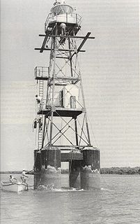
East Vernon Light is an active lighthouse in the Northern Territory of Australia located in the Clarence Strait on the southern coast of East Vernon Island. The lighthouse guards the northeastern approach to Darwin.

Glyde Point is a locality in the Northern Territory of Australia located about 37 kilometres (23 mi) north-east of the territory capital of Darwin.
This page is based on this
Wikipedia article Text is available under the
CC BY-SA 4.0 license; additional terms may apply.
Images, videos and audio are available under their respective licenses.
