| Veurne/Sint-Augustinus Heliport | |||||||||||
|---|---|---|---|---|---|---|---|---|---|---|---|
| Summary | |||||||||||
| Airport type | Public | ||||||||||
| Operator | AZ Sint-Augustinus Veurne | ||||||||||
| Serves | Veurne | ||||||||||
| Location | Belgium | ||||||||||
| Elevation AMSL | 13 ft / 4 m | ||||||||||
| Coordinates | 51°03′44″N002°40′10″E / 51.06222°N 2.66944°E Coordinates: 51°03′44″N002°40′10″E / 51.06222°N 2.66944°E | ||||||||||
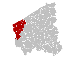
| Map | |||||||||||
 EBVS Location of Veurne/Sint-Augustinus Heliport in Belgium | |||||||||||
| Helipads | |||||||||||
| |||||||||||
Veurne/Sint-Augustinus Heliport( ICAO : EBVS) is a hospital heliport located near Veurne, West Flanders, Belgium.

The ICAOairport code or location indicator is a four-letter code designating aerodromes around the world. These codes, as defined by the International Civil Aviation Organization and published in ICAO Document 7910: Location Indicators, are used by air traffic control and airline operations such as flight planning.

Veurne is a city and municipality in the Belgian province of West Flanders. The municipality comprises the town of Veurne proper and the settlements of Avekapelle, Booitshoeke, Bulskamp, De Moeren (Belgium), Eggewaartskapelle, Houtem, Steenkerke, Vinkem, Wulveringem, and Zoutenaaie.

West Flanders is the westernmost province of the Flemish Region, in Belgium. It is the only coastal Belgian province, facing the North Sea to the north. It has land borders with the Netherlands to the northeast, the Flemish province of East Flanders to the east, the Walloon province of Hainaut in the southeast and France to the west. Its capital is Bruges (Brugge). Other important cities are Kortrijk in the south and Ostend on the coast, Roeselare and Ypres (Ieper). The province has an area of 3,125 km² which is divided into eight administrative districts (arrondissementen) containing 64 municipalities.