
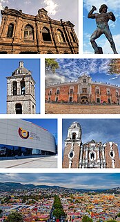
Puebla de Zaragoza, formally Heroica Puebla de Zaragoza, during the colonial times its name was Puebla de los Ángeles, or known in English simply as Puebla, is the seat of Puebla Municipality. It is the capital and largest city of the state of Puebla, and the fourth largest city in Mexico, after Mexico City, Monterrey, and Guadalajara. A viceregal era planned city, it is located in the southern part of Central Mexico on the main route between Mexico City and Mexico's main Atlantic port, Veracruz—about 100 km (62 mi) east southeast of Mexico City and about 220 km (140 mi) west of Veracruz.
Tlaxcala, officially Tlaxcala de Xicohténcatl, is the capital city of the Mexican state of Tlaxcala and seat of the municipality of the same name. The city did not exist during the pre Hispanic period but was laid out by the Spanish as a center of evangelization and governance after the Spanish conquest of the Aztec Empire. It was designated as a diocese but eventually lost this status to Puebla as its population declined. The city still has many of its old colonial structures including the former Franciscan monastery, as well as newer civic structures such as the Xicohtencatl Theatre.

The State of Mexico, officially only Mexico, is one of the 32 federal entities of the United Mexican States. Commonly known as Edomex to distinguish it from the name of the whole country, it is the most populous, as well as the most densely populated, state in the country.

Puebla, officially Free and Sovereign State of Puebla, is one of the 32 states which comprise the Federal Entities of Mexico. It is divided into 217 municipalities and its capital is the city of Puebla.

Tlaxcala, officially the Free and Sovereign State of Tlaxcala, is one of the 32 states which comprise the Federal Entities of Mexico. It is divided into 60 municipalities and its eponymous capital city is Tlaxcala.

Tlaxcala is a state in Central Mexico that is divided into 60 municipalities. According to the 2020 Mexican Census, it is the fifth least populated state with 1,342,977 inhabitants and the 2nd smallest by land area spanning 3,996.6 square kilometres (1,543.1 sq mi).
Emiliano Zapata is a city in the west-central part of the Mexican state of Morelos. It stands at 18°52′N99°09′W. The city serves as the county seat for the surrounding municipality of the same name. The municipality is the sixth largest in the state of Morelos, with a 2020 census population of 107,053 inhabitants, and has it an area of 64.983 km2. The city of Emiliano Zapata had 64,084 inhabitants in 2020. The city was previously known as both San Francisco Zacualpan and San Vicente Zacualpan. It was renamed in honor of Mexican Revolutionary Emiliano Zapata.

Juchitán de Zaragoza is an indigenous town in the southeast of the Mexican state of Oaxaca. It is part of the Juchitán District in the west of the Istmo de Tehuantepec region. With a 2005 census population of 74,714 inhabitants, it is the fourth-largest city in the state. The majority of the indigenous inhabitants are Zapotecs and Huaves. The town also serves as the municipal seat for the surrounding municipality, with which it shares a name. The municipality has an area of 414.64 km² and a population of 85,869, the state's third-largest in population.

Tehuacán is the second largest city in the Mexican state of Puebla, nestled in the southeast of the valley of Tehuacán, bordering the states of Oaxaca and Veracruz. The 2010 census reported a population of 248,716 in the city and 274,906 in the surrounding Tehuacán municipality, of which it serves as municipal seat. The municipality has an area of 390.36 km².

The Archdiocese of Puebla de los Ángeles is a Latin Church ecclesiastical territory or archdiocese of the Catholic Church. It is the oldest Catholic diocese in Mexico. It was established on October 13, 1525 as the "Diocese of Tlaxcala" and retained that name until it was elevated to an archdiocese in 1903. In 1959 a new Diocese of Tlaxcala was created and is suffragan to the Archdiocese of Puebla de los Ángeles.

Mexicali Municipality is a municipality in the Mexican state of Baja California. Its municipal seat is located in the city of Mexicali. As of 2020, the municipality had a total population of 1,049,792. The municipality has an area of 13,700 km2 (5,300 sq mi). This includes many smaller outlying communities as well as the city of Mexicali. Also, the islands of Baja California located in the Gulf of California are part of the municipality, among them the mudflat islands at the mouth of the Colorado River, Isla Ángel de la Guarda and the islands of the San Lorenzo Marine Archipelago National Park. Mexicali is the northernmost municipality of Latin America.
The Metropolitan area of Puebla or Greater Puebla is the fourth largest agglomeration in Mexico with a population of 3.199 million. This agglomeration includes 10 municipalities of the state of Puebla, and 13 municipalities of the state of Tlaxcala. It does not include the city of Tlaxcala.

Apizaco is a city in Apizaco Municipality located near the geographic center of the Mexican state of Tlaxcala, approximately 25 minutes by car from the state's capital city of Tlaxcala. The city gets its name from the Nahuatl language words "ātl" (water), "pitzāhuac" (thin), and the suffix "co" (place), forming "Āpitzāco", or roughly "thin water place". Those seeking to reach the port of Veracruz by railroad from Mexico City must travel through Apizaco. The city began because of its location on this railroad.

Santa Ana Chiautempan is a city in Chiautempan Municipality in the south-central part of the Mexican state of Tlaxcala. The city serves as the municipal seat of the municipality, which covers an area of 66.21 km². At the 2005 census it had a population of 46,776 inhabitants, the fourth-largest community in the state in population. The city lies at the extreme western end of the municipality, which had a census population of 63,300 inhabitants.
Ixtlahuaca de Rayón is the municipal seat and 5th largest city in the municipality of Ixtlahuaca north of Toluca in the northwest part of the State of Mexico, in Mexico. The distance between Mexico City and Ixtlahuaca is 32 km. The name Ixthahuaca comes from Náhuatl and means plains without trees. The city and municipality were officially established by decree on November 14, 1816 by the Congress of the State of Mexico.

Villa de Etla is a town and municipality located in the Mexican state of Oaxaca. It is located in the far northwestern part of the Central Valley of Oaxaca, about seventeen km from the capital. The town is centered on the church and former monastery of San Pedro y San Pablo, and as municipal seat functions as the local government for six other communities. Most of the town's history has been lost due to the lack of records, but oral tradition states that it was founded sometime in the 15th century. Today, the town is noted for its weekly Wednesday market, where one can find traditional merchandise such a local variety of white cheese, tamales, frames for donkeys and goat barbacoa prepared in an earthen oven.
Cuajinicuilapa Municipality is one of the 81 municipalities of Guerrero, in south-western Mexico. The municipal seat lies at Cuajinicuilapa. The municipality covers an area of 857.1 km². As of 2005, the municipality had a total population of 25,537.
Desiderio Hernández Xochitiotzin was a Mexican artist best known for his large-scale mural work inside the State Government Palace in the state of Tlaxcala, Mexico, the last large scale mural of the Mexican muralism movement.

San Quintín is a municipality in the Mexican state of Baja California. Its municipal seat is located in the city of San Quintín, Baja California. According to the 2020 census, it had a population of 117,568 inhabitants. The municipality has an area of 32,883.93 km2. There are a few National Parks and a World Heritage Site at Bahia de Los Angeles.


