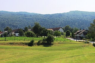
Stari Breg is a settlement in the hills north of the town of Kočevje in southern Slovenia. The area is part of the traditional region of Lower Carniola and is now included in the Southeast Slovenia Statistical Region.
Stari Log is a settlement in the hills north of the town of Kočevje in southern Slovenia. The area is part of the traditional region of Lower Carniola and is now included in the Southeast Slovenia Statistical Region. The village has a cistern and traditional village pond. Raven Spring, a karst spring southwest of the village, is accessible by 13 flights of steps and was once an important site for hunting frogs.
Staro Brezje is a settlement in the hills east of the town of Kočevje in southern Slovenia. The area is part of the traditional region of Lower Carniola and is now included in the Southeast Slovenia Statistical Region.
Stari Kot is a village in the Municipality of Loški Potok in southern Slovenia, next to the border with Croatia. The area is part of the traditional region of Lower Carniola and is now included in the Southeast Slovenia Statistical Region. It consists of the hamlets of Binkl, Kurja Vas, Pri Ambrožiču, Hrib, and Preska. The main road from Lazec to Prezid runs through the village.

Grčarice is a village in the Municipality of Ribnica in southern Slovenia. The area is part of the traditional region of Lower Carniola and is now included in the Southeast Slovenia Statistical Region.

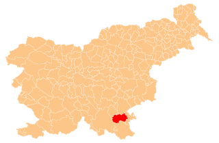
Brezovica pri Črmošnjicah is a small settlement in the Municipality of Semič in Slovenia. The area is part of the historical region of Lower Carniola. The municipality is now included in the Southeast Slovenia Statistical Region.
Gaber pri Črmošnjicah is a small settlement in the hills west of Semič in southeastern Slovenia. The area is part of the historical region of Lower Carniola and is now included in the Southeast Slovenia Statistical Region.
Hrib pri Koprivniku is a remote almost abandoned settlement in the Municipality of Kočevje in southern Slovenia. The area is part of the traditional region of Lower Carniola and is now included in the Southeast Slovenia Statistical Region.
Pugled pri Starem Logu is an abandoned settlement in the hills north of the town of Kočevje in southern Slovenia. The area is part of the traditional region of Lower Carniola and is now included in the Southeast Slovenia Statistical Region.
Ašelice is a remote abandoned settlement in the Municipality of Semič in southern Slovenia. The area is part of the traditional region of Lower Carniola and is now included in the Southeast Slovenia Statistical Region. Its territory is now part of the village of Mašelj. Ašelice lies high on a slope alongside an unpaved road east of Črmošnjice.
Starološki Grič is a remote abandoned settlement in the Municipality of Semič in southern Slovenia. The area is part of the traditional region of Lower Carniola and is now included in the Southeast Slovenia Statistical Region. Its territory is now part of the village of Planina.
Stari Tabor is a remote abandoned settlement in the Municipality of Semič in southern Slovenia. The area is part of the traditional region of Lower Carniola and is now included in the Southeast Slovenia Statistical Region. Its territory is now part of the village of Brezovica pri Črmošnjicah.
Suhi Potok is a settlement in the Municipality of Kočevje in southern Slovenia. The area is part of the traditional region of Lower Carniola and is now included in the Southeast Slovenia Statistical Region.
Gače is a remote abandoned settlement in the Municipality of Semič in southern Slovenia. The area is part of the traditional region of Lower Carniola and is now included in the Southeast Slovenia Statistical Region. Its territory is now part of the village of Komarna Vas and it is registered as a cultural heritage site.

Kleč is a settlement in the Municipality of Kočevje in southern Slovenia. The area is part of the traditional region of Lower Carniola and is now part of the Southeast Slovenia Statistical Region. It no longer has any permanent residents.
Gradec is a remote abandoned settlement in the Municipality of Črnomelj in the White Carniola area of southeastern Slovenia. The area is part of the traditional region of Lower Carniola and is now included in the Southeast Slovenia Statistical Region. Its territory is now part of the village of Rožič Vrh.

Kleč is a remote former settlement in the Municipality of Semič in southern Slovenia. The area is part of the traditional region of Lower Carniola and is now included in the Southeast Slovenia Statistical Region. Its territory is now part of the village of Planina.
Štale is a remote abandoned settlement in the Municipality of Semič in southern Slovenia. The area is part of the traditional region of Lower Carniola and is now included in the Southeast Slovenia Statistical Region. Its territory is now part of the village of Komarna Vas.
Ponikve is a remote abandoned settlement in the Municipality of Semič in southern Slovenia. The area is part of the traditional region of Lower Carniola and is now included in the Southeast Slovenia Statistical Region. Its territory is now part of the village of Planina.
Topličice is a remote abandoned settlement in the Municipality of Semič in southern Slovenia. The area is part of the traditional region of Lower Carniola and is now included in the Southeast Slovenia Statistical Region. Its territory is now part of the village of Sredgora. It lies in a narrow dry valley 1 km east of Sredgora.